Although this upland loch is today renowned as little more than a decent fishing spot, the waters here were long known to be haunted and the abode of a legendary water spirit. In local tradition, the loch is said to be named after “an ancient Chief of Pictish origin” — whose burial mound is nearby — and in James Kennedy’s (1928) fascinating folklore work he also told that,
“Loch Dereculich was the habitation of a ‘Tarbh Uisge’ (water bull), the dangerous water demon… This dreaded monster, as the Norwegian peasant will gravely assure a traveller, demands every year a human victim, and carries off children who stray too near its abode… Less than one hundred and twenty years ago, the Loch Derculich Water Bull was seen sauntering along its shores. At peat-making times it was observed very frequently.”
References:
Kennedy, James, Folklore and Reminiscences of Strathtay and Grandtully, Munro Press: Perth 1928.
From the north side of Killin, take the minor road next to the Bridge of Lochay Hotel at Killin, past the hydroelectric station, through the wooded section until the fields open out again. The first gorgeous old house you come to is on the right-hand side of the road. Stop here! (I could really do with living here misself – tis a truly superb place!) You can ask the lady at the house where the carvings are and she’s very happy to point them out – they’re on the rocky crag near the bottom-end of the field on the other side of the road.
Archaeology & History
R.W.B. Morris sketch of the main carvings
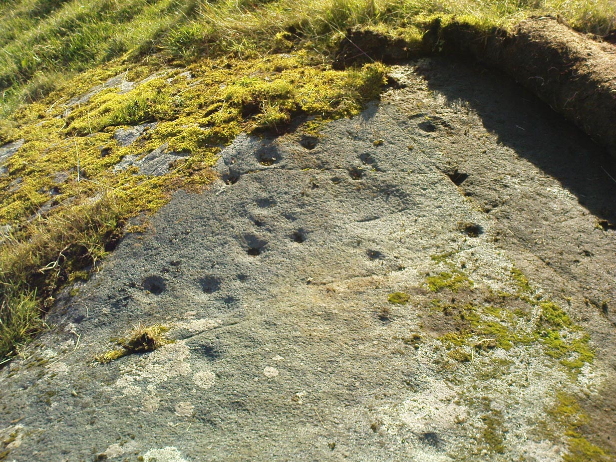
What a brilliant setting and clump of carvings we have here! As you get to the rocky hillock in the field, you see that there are numerous rocks visible along the ridge, a number of which have carvings on them – some with just cups, but most possess a number of cup-and-rings. It’s an excellent spot! Depending on the time of year when you come here will determine whether or not you get a better look at the carvings or not. I’d recommended April and May as the best time, as the vegetation is at its lowest then. Visiting the site near the end of summer doesn’t give you as good a view — but even then, if you like your rock art, you’ll still love it! The rocks here are mainly quartzite schist, with a number of the surfaces being almost pure quartz. Intriguingly, none of the pure quartz sections appear to have been carved on.
The carvings here were first mentioned in an article by D. Haggart (1895), who described them as “a very remarkable set of incised rock sculptures…discovered lately in this neighbourhood by Mr John McNaughton.” And remarkable they are indeed! In Ronald Morris’ (1981) survey of this site — which he labelled Duncroisk 1 — he counted eight separate rock surfaces that had been carved, marking them as carvings a-h, but there are at least eleven of them here; and in all honesty, if we could strip the surface of the hill of its vegetation, we’d probably find a few more hidden away!
Cup-marked stone
As you’ve walked across the field from the road, past the first unrecorded cup-marked stone near the start of the rocky rise, we reach Mr Morris’s ‘stone A’ near the easternmost end of the ridge, which is just a small slab of stone with “at least 6 cup-marks” on its surface. It’s easily missed in poor light, so watch out. However, if you reach ‘stone b’ (described below), just walk back ten steps and you’ll see it.
Carved Stone B
Ten yards west is ‘Stone B’, seemingly split into two sections, whereupon we find “a cup-and-two-rings and at least 12 cups-and-one-ring, up to 19cm in diameter – some rings gapped, others not, some with and some without a radial groove from the cup, and some with a “runner” or cup in a ring. There are also at least 58 cups” on this section of rock. ‘Stone C’ can also be missed, this time due to its size and the fact that the larger cup-marked surfaces are ahead of you. But assuming you don’t miss it, this carving consists of “a well-preserved cup-and-two-complete-rings 25cm in diameter, and a cup.”
Carved Stone D
‘Stone D’ is just next to ‘stone C’, but with rather more ornate designs etched upon it. This is one of the more archetypal petroglyph designs that are found in the photo-guides and textbooks. Morris (1981) told that it consisted “of a cup-and-two-complete-rings and 2 cups-and-one-complete-ring up to 20cm in diameter, also a cup-and-one-complete-ring and 2 cups.” The photo here shows it pretty clearly.
Carved Stone ECurious ‘bowl’, top-centre
‘Stone E’ is the next one along, just a foot or two away and Mr Morris (1981) told that the carving consists of “2 cups-and-one-ring up to 13cm in diameters, 1 complete, the others gapped, joined by groove to a cup, and at least 33 cups (C.G. Cash counted 42 in 1911).” Most of the carved elements on this rock are around the edges of the stone. A very large faded circular depression, man-made, is also visible on this section of the petroglyph (above left), suggestive of lunar symbolism.
Carved Stone F
‘Stone F’ is less than 10 yards further west and has the greatest number of cup-markings of the entire group here, as Morris described: “3 cups-and-one-complete-ring up to 9cm in diameter, and at least 80 cups, a few of which are widely scattered over a big area sloping steeply further south, beyond the attached diagram.” It’s perhaps the most notable of the carved rocks along the ridge here — not by virtue of its design, more its geological physique than anything else.
Carved stone G
‘Stone G’ is next along and has a curious look about it, suggestive of more modern times. At first sight it doesn’t seem to have quite the magnitude that Morris’ description affords it, but on closer inspection by rolling some of the covering turf back away from the rock, you can see what he meant. This stone has “10 cups-and-one-complete-ring, up to 10cm diameter…and also 15 cups.” One of the cup-and-rings on this section was found by Morris to have been “the smallest so far recorded by the author in Scotland.”
Then we reach ‘stone H’ at the eastern end of the carved ridge, consisting of simply 3 cup-markings. One of them has a faint arc pecked around it. Further along the rock, a complete cup-and-ring is visible close to the edge.
This entire line of petroglyphs is a fine place in a fine setting, perfect for meditative practices! Other carvings can be found close by: Duncroisk 3 is a coupla hundred yards east across the field just over the fence by the riverside; and Duncroisk 2 is on the other side of the fence down towards the River Lochay on the same side of the adjacent burn less than 100 yards away (though this is trickier to reach). Other prehistoric sites can be found not too far away…
Folklore
Local people tell of having seen curious lights flitting along the edges of the field, river Lochay and roadside close to the carved rocks hereby.
From Killin, take the Glen Lochay Road past the Moirlanich Longhouse, but keep on for another mile, and take the track on the left up to Murlaganmore cottages. As the track turns right of the tree-line, cross the field (left) up towards the open gate as if you’re going to the Murlaganmore 2 carving, where you’ll see this large flattish rock in the grasses about 100 yards before it.
Archaeology & History
When we visited this old boulder last week, we had the misfortune of grey days and dark clouds throwing their faded light across this cup-marked rock, not really letting us see with any clarity the many cups which pepper (mainly) the edges of the rock. But the cups are faded anyway, so accounts tell, and the 15 which we counted were same 15 recorded about 100 years ago in C.G. Cash’s (1912) survey. There, he described this old stone as,
“about 200 yards south of the house, in the middle of the uppermost pasture. It is a large block of quartz schist stuck thick with garnets, and bearing fifteen cup-marks, only one of which — 3 inch in diameter and 1 inch deep — is really well defined, and several of which are faint.”
Faint cups barely visibleC.G. Cash’s early drawing
But despite the grey day (She was absolutely teeming with rain half of the time!), I found the setting here absolutely gorgeous, with the many shades of old trees and the clear blood of pure waters falling through the landscape. And, without doubt, there are other carved stones nearby that have yet to capture the attention of surveyors. You can smell them!
References:
Cash, C.G., ‘Archaeological Gleanings from Killin,’ in PSAS 46, 1911-12.
Royal Commission on Ancient & Historical Monuments, Scotland, The Archaeological Sites and Monuments of Stirling District, RCAHMS: Edinburgh 1979.
From Killin, take the small road to the Moirlanich Longhouse, but keep on for another mile. Just before the road crosses the river, stop! In the fields above you to the left are a few trees and some rocks. Walk uphill till you’re nearly level with the cottages at Murlaganmore (the gate’s about 10-15 yards away) just above the gorze bushes and check out the long rock. If you can’t see it at first, bimble about till you find it. You’re just about on it!
Although shown on modern OS-maps as a ‘Sculptured Rock’ and included in the Canmore survey, when we visited this site a few days ago I have to say that unless evidence to the contrary can be obtained, this ‘site’ should be declassified as an archaeological remnant of the prehistoric period. It appears to be natural — though could have had some agricultural purpose or origin in centuries past.
The ‘footprint’ appears to have been described first of all by F.W.L. Thomas (1879) in his essay on the inaugural seat of Kings at Dunadd, where a similar footprint is found at the top of the fort. Thomas thought that this curious footprint could have had a similar function — though even folklore hereabouts seems silent on such a matter. The site is included in Ron Morris’ 1981 survey, where he too described it as “probably natural but just possibly man-improved.”
References:
Morris, Ronald W.B., The Prehistoric Rock Art of Southern Scotland, BAR: Oxford 1981.
Thomas, F.W.L., ‘Dunadd, Glassary, Argyllshire: The Place of Inauguration of the Dalriadic Kings’, in Proc Soc Antiq Scot, vol.13, 1879.
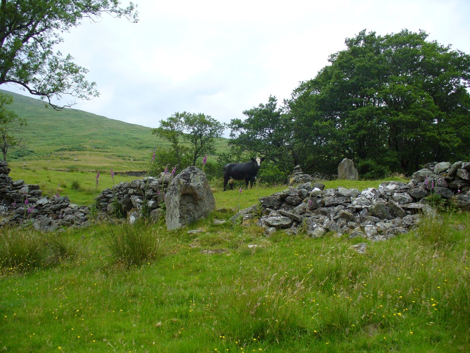
From Killin, travel down Glen Lochay, past Stag Cottage or Duncroisk and over the shallow river of Allt Dhun Croisg. If you’re in a car you can park up a 100 yards past the river bridge and walk up the track from here. After a 10 minute walk, above the trees you come to the derelict village of Tirai* where, until recently, you were greeted by a tall totem-pole of a gnarled tree (it was superb!) which is now Earth-lain, and a fine view of the evolving hills. Here amidst the ruins we also find a standing stone or two.
Archaeology & History
The village of Tirai was deserted sometime in the 19th century (due to the disgusting clearances of the English), but at least two standing stones still live amidst its ruins. The tallest is nearly four-feet tall in the middle of the grassy patch and is much used by grateful cattle to rub themselves against when midges and horseflies drive them mad! The Scottish Royal Commission lads reckon the megaliths here are,
“possibly a survivor of a stone circle as a similar stone is used nearby as a gate-post to an enclosure and several other large stones have been incorporated in the walls of the surrounding buildings.”
This may well be so – but it is equally possible that these are merely the remains of standing stones which once stood along this ridge and which were taken for use in the village.
One of the Tirai standing stones
Of the remaining standing stones in this idyllic setting – the Royal Commission fellas counted possibly four of ’em – all are roughly the same size, between 3 and 4 feet high. Johnstone & Wood (1996) also think the stones here may once have related to a prehistoric cairn in the village.
This is an utterly beautiful arena, even in the heights of winter. The village sits on the rear slopes behind the old cailleach, and there are plenty of cup-and-ring carvings, both known and unknown scattering the rocks and nearby hills. The curious Duncroisk Crosses carving is just visible from here, on the other side of the rocky gorge. Lost tales and lost sites abound here also. I did sit and wonder though… Considering that the villagers here left the old standing stones in place until very recent centuries at the heart of their hamlet, what uses did they make of it, or what tales did it speak? Or had the purge of the Church already taken its toll…?
References:
Gillies, William A., In Famed Breadalbane, Munro Press: Perth 1938.
Johnstone, A.S.K. & Wood, J.S., ‘An Archaeological Field Survey of Deserted Townships at Tirai, Glen Lochay, Killin,’ Association of Certificated Field Archaeologists (Glasgow University) Occasional Paper no 9 (1996).
* The place-name Tirai means ‘land of good luck or joy,’ which truly speaks well of its spirit and setting to me.
Another silly-sounding directional pointer! Get to the now tourist-infested town of Killin (best in Winter, when the town is quiet and you get to know the locals a lot better) and travel through it as if you’re going to follow Loch Tay up its western side. As you’re going out of the village towards the Bridge of Lochay Hotel (an excellent place), you’ll see an amphitheatre of mountains in the background. The tallest of the hills on the left is where you’re heading. Go straight up the hillside and follow your nose!
Creag na Cailleach, Killin
The hill guards the entrance to the legendary Glen Lochay (Valley of the Black Goddess). There are many ways to climb her, but my first venture here took me up the waterfalls and steepish burn of Allt na Ceardaich. Once on the level, I found myself surrounded by that amphitheatre I mentioned, from where – on my first visit – I took up the sheer face of this great mountain. (to be honest it’s nowt special if you’re into mountaineering) From the tops you’ve got a damn good view all round. But respect this old hill, as danger awakens to idiots who would think themselves champions.
Folklore
Here, where axes were quarried by ancient man from beneath Her rocky slopes, this ‘Hill of the Old Woman’, or ‘Hag’, was one of the abodes of the primal Mother Goddess in olden times, so says her name. Her ‘dark’ aspect seemed manifest one time when I climbed her with a rather stupid man in tow. Following one of the streams back into the valley below, he thought it wise to copy my gazelle-nature as I sprang without thought, quickly, from rock to rock, bouncing at speed down the fast-flowing stream (which takes a lotta weird practice and very strong ankles!), in spite of the advice to do otherwise – and in doing so he broke his leg in three places and, to make it worse, had to spend the night there in complete agony!
Don’t tell me there’s no ‘dark’ goddess to some of these great places!
Axe production has been found to have occurred as early as 2500 BC. There have been numerous flint finds hereabouts aswell – but considering this is a mountain, you’d expect to find something on or about Her slopes!
I’ve just been back up here as the first good snow fell upon the hills and the white cover brought the elements out of her form in a way I’d not seen before. Tis a wonderful place the Creag na Cailleach; and, it seems, a site that played a now forgotten part in the ancient name of the glen, Lochay, which was the living abode of the Black Goddess in more archaic days. Twouldst be good to hear some of the authentic old stories from old locals that were once known of this ancient deity in the glens. If anyone knows of such tales, let us know before they are lost forever…
References:
Ritchie, P.R., ‘The Stone Implement Trade in Third Millenium Scotland,’ in Coles & Simpson’s, Studies in Ancient Europe, Leicester University Press 1968.
Acknowledgements: Huge thanks to Lindsay Campbell for her hospitality, food and roof hereby.
From the north-end of Loch Tay at Kenmore, follow the road (A827) round down the lochside, through the village of Fearnan and then another 4 miles down. If you park up at the pub at Lawers, walk back up the road for ½-mile, keeping your eyes peeled up the slope on the left where you’ll see the circle visible from the road.
Archaeology & History
Much has been said of this fine old place – also known as Lawer’s Mill – which seems to have been first described by Thomas Pennant in his rambling Tour in Scotland (1772). The local writer William A. Gillies (1938) told that after
“a recent examination of the ground around the circle…suggests that at one time there was an outer circle of stones concentric with the existing one. Most of the stones were removed in order to make more of the field available for cultivation, but there are still large stones buried within a few inches of the surface.”
Folklore
In J. McDiarmid’s Folklore of Breadalbane (1910) he tells of a man from Killin who, on passing by this old circle, heard haunting fairy music. Being inquisitive, he walked up to see what was going on and walked into the circle where the little people were playing. He was obviously lucky and the faerie-folk enjoyed his company, for when he left he was given the gift of a strong, fast, white steed.
Solar folklore may be…?
References:
Gillies, William A., In Famed Breadalbane, Munro Press: Perth 1938.


")