In this region so full of old tombs and prehistoric remains, we find this little-known sacred well, long since known as a place of curious sprites and strange lore. Elizabeth Wright (1913) said of the place,
“It is said that the fairies were wont of old to wash their clothes in Claymore Well, and mangle them with the bittle and pin. The bittle is a heavy wooden battledore; the pin is the roller; the linen is wound round the latter, and then reolled backwards and forwards on the table by pressure on the battledore. The strokes of the bittles on fairy washing-nights could be heard a mile away.”
A most curious tale…
References:
Wright, Elizabeth Mary, Rustic Speech and Folk-lore, Oxford University Press 1913.
Healing Well (destroyed): OS Grid Reference – SE 0479 4179
Archaeology & History
The Whin Knoll Well, once found bursting into life at the top of Black Hill, Keighley, got its name from the old word ‘whin,’ or gorse bushes (Ulex Europaeus)—also known in Yorkshire as the ‘Spindly Killer Bush’: a most apt title! These great spindly killer shrubs once profused where the waters of this old well used to bubble into view – indeed, there are still quite a few great old spindlies still scattered here and there!
The site was shown on old maps as being just two fields east of the more renowned Jennet’s Well, but this old public water supply that once fed the local people, was covered by a reservoir many moons ago. However, a wander up here recently found the reservoir empty, but a water supply was still bubbling out of the ground into the great concrete hollow. The last remnants of the Whin Knoll Well perhaps…?
Dead easy! Get to Ilkley train station and look across the road to your left, cross it and walk along. 100 yards on is Cowpasture Road. Walk up it! You’ll be at the rocks in 10-15 minutes.
Archaeology & History
Cow & Calf Rocks from above – thanks to Ian Hay’s superb ‘Yorkshire from the Air’
There’s nowt specifically archaeocentric directly relating to these great rocks — well, nowt that’s been found out about anyway! — though all around here over the last coupla centuries people have found numerous flints, and we have various examples of rock-art (cup-and-rings) carved on rocks close by. There have been attempts to verify what may be cup-marks on both the Cow and the Calf — with the old master, Harry Speight (1900) telling how there used to be remains of cups and lines on the rocks, but apart from some well-worn ‘cups’ on some of the edges, these seem hard to find. For worrits worth: if Speight said there were some carvings here, its more than likely true.
I think the main relationship ancient man would have had with this great rock outcrop would have been a ritual one: the rocks themselves had no need of human imprints: their size and nature would deem them of great spirit indeed, to anyone with an ounce of feeling. Not sure that’s the way most modern folk would see things – but that’s to be expected I s’ppose!
Folklore
These grand rocks once had the even greater Bull Rock as a close companion. It was on top of this, wrote Eric Lodge (1939:40), that,
“the only point in the immediate vicinity of Ilkley from which a view of York Minster was obtainable. ‘Tis some sixty years ago, however, that a local tradesman recognised its value in building stone, and despite strong protests, quarried it for the construction of the Crescent Hotel, situated at the corner of Brook Street and Leeds Road in Ilkley.”
The matter was described in the Leeds Mercury in 1899, thus:
“About the year 1850 an act of vandalism was perpetrated at Ilkley, which would have been impossible in these days, when the Ilkley Local Board watches with such a keen eye anything that may enhance the historical interest of this rapidly increasing watering-place.
“Below the two huge rocks known as ‘The Cow and Calf,’ which have attracted thousands of visitors and invalids on to the breezy heights whereon they stand, stood a rock larger than the Calf, which was known as the ‘Bull.’ It was much nearer the highway than the Calf…
“The ‘Bull’ rock had its name cut in large letters on the side that lay nearest the road, and it is much to be regretted that an unfortunate dispute between the owners of the free-hold and the lord of the manor, in which the former won the day, gave them the right to break up this noble rock and cart it away for building purposes. It is said that the Crescent Hotel was mainly built from this stone, so some idea may be formed of its vast size and proportions.”
Incredible – they’ve turned a gigantic sacred rock into a large hotel! (and I’ve never been in it) Let’s hope it’s haunted to buggery! Does anyone know any Fortean history about the place?
Another legend tells that one day the local giant, Rombald (who gave his name to these moors and lived up here, somewhere, with his even greater but unnamed wife), decided to meet a friend a few miles away to the east, at Almscliffe Crags. So in just one step he strode over the Wharfe valley right across to the legendary crags, but he slightly stumbled and in doing so, left he footprint embedded on the face of the Cow Rock, which can still be seen today.
In modern times, the Cow & Calf have been the centre for occasional UFO, or earthlight sightings. But this appears to go back a bit earlier than when such curious light-forms were thought of as visiting ETs; for good old Nicholas Size (1936) reported seeing burning lights and curious figures up here — but when he saw these lights they took the form of druids and pagan spirits. One wonders what they’ll morph into next!
Somewhat out of the way with seemingly nothing left of the site, from Clachan Strachur, take the A886 road southwest along Loch Fyne for a few miles until you turn right (make sure you don’t drive past it!) towards Garbhallt. Go through here and on for another mile until you see a rounded knoll in the forest to your left (if you hit Barnacarry house, you’ve gone too far). Tis upon this hill where our old stone once stood.
Archaeology & History
Nowt much to write really. A description many moons back told there was an old stone standing ‘pon this hill. It was only a small creature compared to many of Argyll’s monoliths, only three-and-half feet tall, all alone, looking across the loch and speaking with the hills a gentle voice. I found it a little odd (though aint been here for many years) and seemed to tell that a tomb was in attendance, but this too seemed long gone. The Royal Commission chaps thought that some of the other slabs of stone lying about here may have been relevant, but we may never know. I reckon a few good days ambling hereabouts would produce some new finds. And the fact that only a half-mile away we find an old cross and holy well seems to indicate a christian rendering of something heathen close by…..
References:
Royal Commission on the Ancient & Historical Monuments of Scotland, Argyll – volume 6: Mid-Argyll and Cowal, HMSO: Edinburgh 1988.
Standing Stone (destroyed): OS Grid Reference – NT 038 456
Archaeology & History
This standing stone used to be positioned on the old boundary line between the Carnwatch and Dunsyre parishes. It might be a good idea to check out the perambulation records to see if owt went off here, before its destruction. About five-feet tall, it was positioned on a small rise in the ground, 500 yards south of Todholes.
References:
Royal Commission on the Ancient & Historical Monuments of Scotland, Lanarkshire: Prehistoric and Roman Monuments, HMSO: Edinburgh 1978.
Standing Stone (destroyed): OS Grid Reference – NS 759 351
Archaeology & History
The name of the place sort of gives the game away, but sadly we’ve got nowt to see anymore as the forest has covered it. The Royal Commission lads came here in 1971 and couldn’t find it, but later told that it “formerly stood on the summit” of the said hill. An important geomantic spot without any shadow of a doubt, probably having some relationship with an old tomb, either here or around the tree-covered summit of Tod Law, due east of here.
There’s a great deal more that’s been forgotten about up and about this region which will come to light as visits unfold.
References:
Royal Commission on the Ancient & Historical Monuments of Scotland, Lanarkshire, HMSO: Edinburgh 1978.
Standing Stone (destroyed): OS Grid Reference – NS 681 490
Archaeology & History
This is another Lanarkshire monolith that’s gone, but which was described first of all in the 19th century in the Ordnance Survey place-name book for the county. The Scottish Royal Commission (1978) lads—who tried locating the site in September, 1973—told that,
“no trace now survives of the stone, 1.4m in height (i.e., about four-and-half feet tall – Ed.), that once stood in a field beside the public road about 120m northeast of Shawton Farmhouse.”
References:
Royal Commission on the Ancient & Historical Monuments, Scotland, Lanarkshire: Prehistoric and Roman Monuments, HMSO: Edinburgh 1978.
Standing Stone (destroyed): OS Grid Reference – NS 832 426
Archaeology & History
The first reference I found of this once-proud standing stone was in the early pages of the Glasgow Archaeological Society’s Transactions, from 1897; but when the Royal Commission lads came to look for the site in 1971, it had long-since been destroyed. Thankfully we have various folklore relics to tell us more!
Folklore
In Robert Chambers’ Popular Rhymes (1826), he told us several intriguing pieces of folklore about this once great monolith, writing:
“On the farm of Clerkston, in the parish of Lesmahagow, there had existed since creation an immense stone, or saxum, which, being deeply bedded in the middle of a good field, at a great distance from any other rocks, was productive of infinite inconvenience to the husbandman, and defrauded the proprietor of a considerable portion of territory.
“Beneath this stone, it was believed by the country people of the last generation, that there was secreted a vast treasure, in the shape of “a kettle-full, a boot-full, and a bull-hide-full,” of gold; all which got the ordinary name, reason unknown, of “katie Neevie’s hoord.” The credibility of this popular tradition was attested by a rhyme to the following effect:
Between Dillerhill and Crossfoord,
Here Lies Katie Neevie’s Hoord.
“Many efforts had been made, according to the gossips, to remove the stone, and get at the treasure; but all were baffled by the bodily appearance of the enemy of mankind, who, by breathing intolerable flame in the faces of those making the attempt, obliged them to desisted. Thus well guarded, the legacy of Mrs. Katherine Niven lay for centuries as snug as if it had been deposited in Chancery; and it was not till at least an hundred years after the last despairing effort had been made that the charm was at length broke.
“Mr James Prentice, the present farmer of Clerkston, had the address to convince several Irishmen, who had served him during the harvest, of the truth of the said rhyme; and, by expatiating upon the supposed immensity of the treasure, wrought up their curiosity and their cupidity to such a pitch, that they resolved, with his permission, to break the stone in pieces, and make themselves master of whatever might be found below. On the day after the kirn, therefore, the poor fellows provided themselves with a well-loaded gun, for the protection of their persons from the Devil, and fell to work, with punches and mallets, to blow up and utterly destroy the huge stone which alone intervened between them and everlasting affluence.
“They laboured the whole day, without provoking any visit from Satan, and at last succeeded in fairly eradicating the stone from the field which it had so long encumbered; when they became at once convinced of the fallacy of the rhyme, of the craft of Mr. Prentice, and of their own deluded credulity.”
References:
Chambers, Robert, The Popular Rhymes of Scotland, William Hunter: Edinburgh 1826.
Royal Commission for the Ancient & Historical Monuments of Scotland, Lanarkshire: Prehistoric and Roman Monuments, HMSO: Edinburgh 1978.
The grid reference here is an approximation, but the old well was definitely somewhere very close by, as evidenced by the place-name of the farmhouse. But if you wanna get here and wander about in the hope that you can re-locate this once sacred water source, go up the B1269 road north of Guisborough for about a mile. Carling Howe farmhouse is on the left-hand side of the road. Obviously the old well is somewhere close by…
Archaeology & History
The information I have of this site comes from old place-name listings. I found the reference in the directory for North Yorkshire by A.H. Smith (1928), in his entry for the etymology of ‘Carling Howe’ at Guisborough. Smith ascribes the references of ‘Kerlinghou’ (which itself appears to have been lost) to mean the ‘Old woman’s mound’ and variants thereof, also saying, “There is an unidentified place in this township called Kerlingkelde,” (12th century ref. Guisborough Cartulary)—the ‘Old Woman’s Well’. Very commonly in this part of Yorkshire—as at many other locations in northern England—a hou or howe (and variants thereof) relates to a prehistoric tomb – which is probably what we had here: a prehistoric Old Woman’s Grave with an associated Old Woman’s Well in close attendance.
The ‘old woman’ element in this name very probably relates to that primal mythic deity, the cailleach, the great prima mater of indigenous heathen folk, beloved mainly in Scottish and Irish lore, where her copious name and tales resonate to this day. This “well of the Old Woman, or cailleach“, would have been a place of particular importance in the mythic cosmology of our ancestors, but its precise whereabouts seems forgotten. There is a plentiful supply of water around Carling Howe Farm, one or more of which may once have been the site of this well. However, a lot of quarrying operations occurred here in the not-too-distant past, and this may have irreparably damaged our ability to accurately find the site – though perhaps a perusal of old field-maps could be productive.
It would also be good if we could locate the original whereabouts of the old tomb here which gave the place its name – the ‘Carling Howe’. Other ‘howe’ sites in East and North Yorkshire turn out to be prehistoric burials and I have little doubt that the same occurred here.
References:
o’ Crualaoich, Gearoid, The Book of the Cailleach, Cork University Press 2003.
Smith, A.H., The Place-Names of the North Riding of Yorkshire, Cambridge University Press 1928.
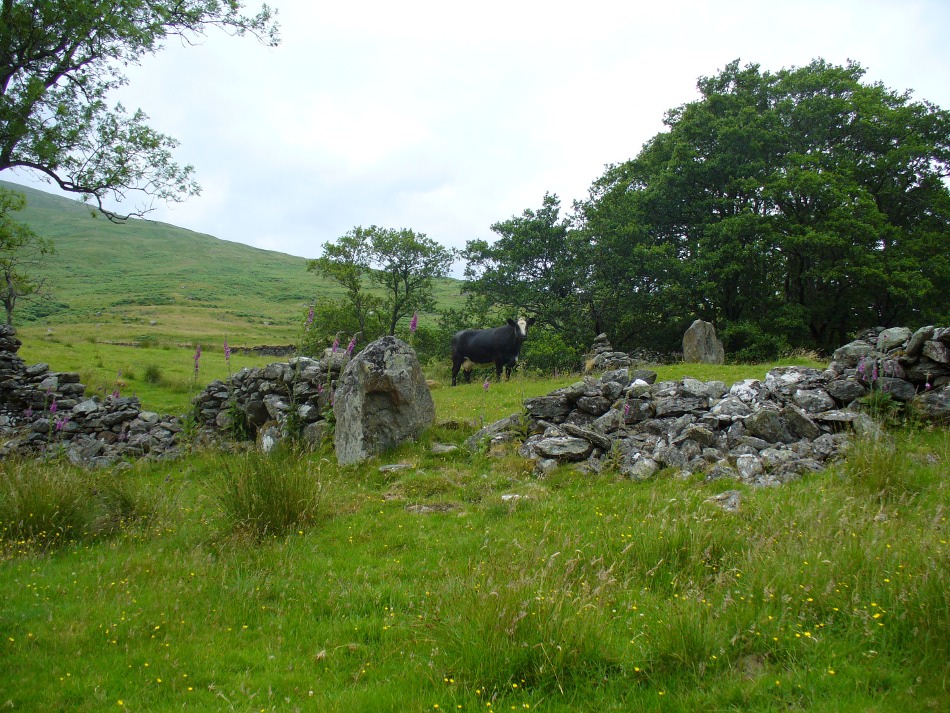
From Killin, travel down Glen Lochay, past Stag Cottage or Duncroisk and over the shallow river of Allt Dhun Croisg. If you’re in a car you can park up a 100 yards past the river bridge and walk up the track from here. After a 10 minute walk, above the trees you come to the derelict village of Tirai* where, until recently, you were greeted by a tall totem-pole of a gnarled tree (it was superb!) which is now Earth-lain, and a fine view of the evolving hills. Here amidst the ruins we also find a standing stone or two.
Archaeology & History
The village of Tirai was deserted sometime in the 19th century (due to the disgusting clearances of the English), but at least two standing stones still live amidst its ruins. The tallest is nearly four-feet tall in the middle of the grassy patch and is much used by grateful cattle to rub themselves against when midges and horseflies drive them mad! The Scottish Royal Commission lads reckon the megaliths here are,
“possibly a survivor of a stone circle as a similar stone is used nearby as a gate-post to an enclosure and several other large stones have been incorporated in the walls of the surrounding buildings.”
This may well be so – but it is equally possible that these are merely the remains of standing stones which once stood along this ridge and which were taken for use in the village.
One of the Tirai standing stones
Of the remaining standing stones in this idyllic setting – the Royal Commission fellas counted possibly four of ’em – all are roughly the same size, between 3 and 4 feet high. Johnstone & Wood (1996) also think the stones here may once have related to a prehistoric cairn in the village.
This is an utterly beautiful arena, even in the heights of winter. The village sits on the rear slopes behind the old cailleach, and there are plenty of cup-and-ring carvings, both known and unknown scattering the rocks and nearby hills. The curious Duncroisk Crosses carving is just visible from here, on the other side of the rocky gorge. Lost tales and lost sites abound here also. I did sit and wonder though… Considering that the villagers here left the old standing stones in place until very recent centuries at the heart of their hamlet, what uses did they make of it, or what tales did it speak? Or had the purge of the Church already taken its toll…?
References:
Gillies, William A., In Famed Breadalbane, Munro Press: Perth 1938.
Johnstone, A.S.K. & Wood, J.S., ‘An Archaeological Field Survey of Deserted Townships at Tirai, Glen Lochay, Killin,’ Association of Certificated Field Archaeologists (Glasgow University) Occasional Paper no 9 (1996).
* The place-name Tirai means ‘land of good luck or joy,’ which truly speaks well of its spirit and setting to me.