St. Michael’s Well, Well, North Yorkshire

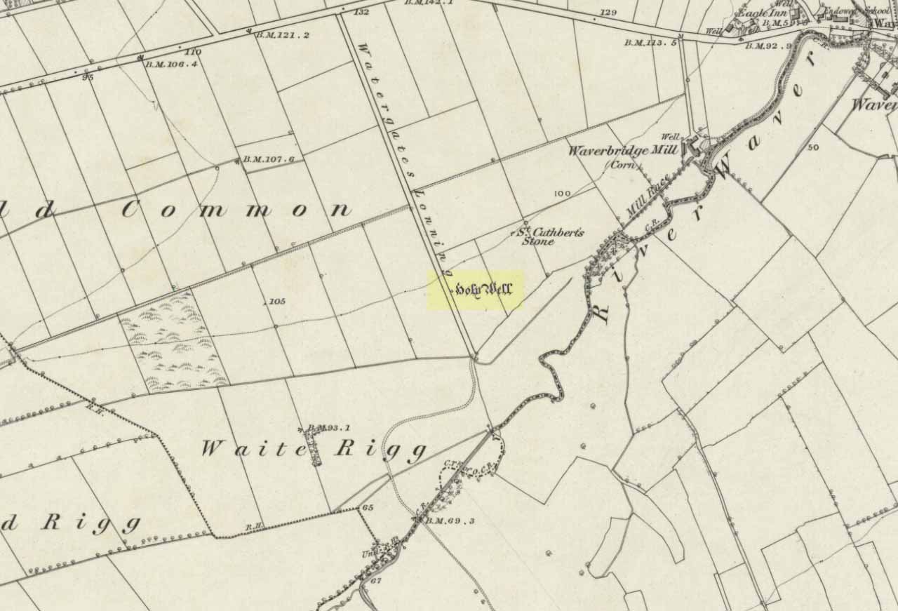
Holy Well:  OS Grid Reference – SE 2633 8176

Also Known as:

  1. Mickel Well
  2. Mickey Well

Getting Here

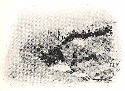
Found near the bottom of Holly Hill, as Graeme Chappell tells us, this old site “is located by the side of a narrow lane on the west side of the village of Well (aptly named). The OS map places the well on the north side of the lane, but this is only the outflow from a pipe that carries the water under the road.  The spring actually rises at the foot of a small rock outcrop, on the opposite side of the road.”

Archaeology & History

St. Michael's Well, Well (Bogg 1895)
St. Michael’s Well, Well (Bogg 1895)

Although the village of Well is mentioned in Domesday in 1086 and the origin of the place-name derives from “certain springs in the township now known as The Springs, St. Michael’s Well and Whitwell,” very little appears to have been written about this place.  Edmund Bogg (c.1895) wrote that an old iron cup — still there in the 19th century — was attached next to this spring for weary travellers or locals to partake of the fine fresh water.  Nearby there was once an old Roman bath-house and, at the local church, one writer thinks that the appearance of “a fish-bodied female figure…carved into one of the external window lintels” is representative of the goddess of these waters.  Not so sure misself — but I’m willing to be shown otherwise.

Folklore

Around 1895, that old traveller Edmund Bogg once again wrote how the villagers at Well village called this site the Mickey or Mickel Well,* explaining: “the Saxons dwelling at this spot reverently dedicated this spring of water to St. Michael.” A dragon-slayer no less!

Although not realising the Michael/dragon connection, the same writer later goes on to write:

“There is a dim tradition still existing in this village of an enormous dragon having once had its lair in the vicinity of Well, and was a source of terror to the inhabitants, until a champion was found in an ancestor of the Latimers, who went boldly forth like a true knight of olden times, and after a long and terrible fight he slew the monster, hence a dragon on the coat of arms of this family. The scene of the conflict is still pointed out, and is midway between Tanfield and Well.”

This fable occurred very close to the gigantic Thornborough Henges!  It would be sensible to look more closely at the mythic nature of this complex with this legend in mind.  A few miles away in the village of Kirklington, the cult of St. Michael could also be found.

References:

  1. Bogg, Edmund, From Eden Vale to the Plains of York, James Miles: Leeds n.d. (c.1895)
  2. Smith, A.H., The Place-Names of the North Riding of Yorkshire, Cambridge University Press 1928.

* In old english the word ‘micel‘ (which usually accounts for this word) means big or great. On the same issue, the ‘Holly Hill’ in the case here at Well actually derives from the holly tree and NOT a ‘holy’ well. However, check the folklore of this tree in Britain and you find a whole host of heathen stuff.

© Paul Bennett, The Northern Antiquarian


Elm Crag Well, Bingley, West Yorkshire

Healing Well:  OS Grid Reference – SE 1028 3907

Getting Here

From Bingley, take the B6429 road up to Harden.  After going up the wooded winding road for a few hundred yards, stop where it levels out.  Cross onto the right-hand side of the road and walk up the slope a little, veering to your right.  You’ll notice a small disused building just off the roadside, in overgrowth, with a pool of water.  You need to be about 100 yards up the slope above it!

Archaeology & History

Elm Crag Well, Bell Bank Wood, Bingley

This is a beautiful old place.  If you walk straight up to it from the roadside, past the derelict building, you have to struggle through the brambles and prickly slope like we did – but it’s worth it if you like your wells!  However, if you try getting here in the summertime, expect to be attacked on all sides by the indigenous flora!  The waters here emerge from a low dark cave, in which, a century of three ago, someone placed a large stone trough.  When I first came here about 25 years ago, some halfwits had built an ugly red-brick wall into the cave which, thankfully, someone has had the sense to destroy and rip-out.

Shown on the 1852 Ordnance Survey map and highlighted as a ‘spring,’ Harry Speight (1898) gives a brief mention to this site, though refers us to an even earlier literary source when it was first mentioned. In John Richardson’s 18th century survey of the Craven area, he makes reference to an exceedingly rare fern, Trichomanes radicans, which was later included in Bolton’s classic monograph on British ferns of 1785.  In it, Bolton wrote that the very first specimen of this plant was “first discovered by Dr. Richardson in a little dark cavern, under a dripping rock, below the spring of Elm Crag Well, in Bell Bank.”

Elm Crag Well
Elm Crag Well

The waters from here come from two sides inside the small cave and no longer run into the lichen-encrusted trough, seemingly just dropping down to Earth and re-emerging halfway down the hillside.  But the waters here taste absolutely gorgeous and are very refreshing indeed!  And the old elms which gave this old well its name can still be seen, only just hanging on to the rocks above and to the side, with not much time left for the dear things.

References:

  1. Bolton, James, Filices Britannicae: An History of the British Proper Ferns, Thomas Wright 1785.
  2. Speight, Harry, Chronicles and Stories of Old Bingley, Elliott Stock: London 1898.

© Paul Bennett, The Northern Antiquarian


Haworth Moor Spa Wells, West Yorkshire

Healing Wells:  OS Grid Reference – SE 0041 3513

Getting Here

Spa Wells on 1852 map

Go through Haworth and head for the well-known Penistone Hill country park.  On the far western side of the hill up near the top of Moorside Lane, there’s a car-park.  Right across the road from this there are two footpaths: one heads you into the moor, whilst the other (going the same direction) follows the edge of walling onto the moors.  Take this path. Walk on and downhill, past the end of the reservoir, then the path continues uphill. You’ll hit a nice cheery tree beside the path a few hundred yards up.  Stop here, look into the boggy region with bits of walling on the moor in front of you.  That’s where you’re heading!

Archaeology & History

The first, weaker of the Spa Wells

This was a really curious spot to me, as I found absolutely nothing about the damn place!  But thanks to the assistance of local historian and writer Steven Wood (2009), that’s changed.  Shown on the 1852 OS-map, at least two springs of clear water trickle slowly from the wet slope above you into the boggy reeds.  Close by there are overgrown remains of old buildings, covered with the time of moorland vegetation, seemingly telling that the waters were collected for bathing rooms.  But who the hell even started the notion that they’d be able to get Victorian rich-folk up here at the crack-of-dawn to drink or bathe in the waters is seemingly forgotten.  And, as is evident from the lack of local history, the project was a failed one which seemed not to have lasted too long. 

Folklore

The stronger of the Spa Wells
The stronger Spa Well

It was quite obvious that of all the springs around here and despite the strong-flowing streams either side of these spa well, that the local animals drink here more than the other nearby springs of water, as there were literally hundreds of animal tracks all across the boggy ground of the spas.*  The waters also seem to have the usual ‘spa’ qualities of stinking, but once we’d cleaned out the overgrown springs — which looked as if they hadn’t been touched for 100 years or more the waters were clear and tasted good, and were curiously slightly warm!

Although my initial search for information on this site drew a blank, Steve Wood pointed us in the right direction for info on the place.  As with many other holy wells and spas in Yorkshire, it turned out that this was another spot much revered around Beltane, indicating strongly there would have been  earlier pre-christian rites practiced at this site.   Steve pointed me to Martha Heaton’s (2006) local history work, which told:

“For many years the first Sunday in May was a special day. It was known as Spa Sunday, for on this day people gathered up in the hills overlooking what is now Leeshaw Reservoir, here was a well, known as Spa Well, and the stream which now feeds the reservoir is known as Spa Beck. People came from Haworth, Oxenhope, Stanbury, and other villages sitting round the well, they sang songs, some bringing their musical instruments to accompany the singing. Children brought bottles with hard spanish in the bottom filling the bottle with water from the well, shaking it until all the spanish or liquorice had been dissolved. This mixture was known as ‘Poppa Lol’ and would be kept for weeks after a little sugar had been added, then it was used sparingly as medicine.  The custom seems to have died out when Bradford Corporation took over the water and made Leeshaw Compensation Reservoir in 1875, though up to about 1930 two men from Haworth would wend their way to the spot on the moor, the first Sunday in May. The men were John Mitchell and Riley Sunderland, better known, in those days as ‘Johnny o’Paul’s’ and ‘Rile Sun’.

It was a great day for many people, the Keighley News of May 1867 mentioned it, the report of local news reads thus: ‘A large assembly met on Spa Sunday on the moors about two miles from Haworth, and a party of musicians from Denholme performed sacred music’.

This locality was often visited during the summer months by the Bronte family.”

References:

  1. Heaton, Martha, Recollections and History of Oxenhope, privately printed 2006.
  2. Wood, Steven & Palmer, Ian, Oxenhope and Stanbury through Time, Amberley Publishing 2009.

Acknowledgements: – Huge thanks to Steven Wood for his help; and to Hazel Holmes for permission to quote from Martha Heaton’s work.

* A common creation myth behind many healing wells is that animals with breaks or illness drag themselves to drink from otherwise small or insignificant springs and wells, despite of the copious streams or rivers which may be nearer.

© Paul Bennett, The Northern Antiquarian


Robin Hood’s Well, Stanbury Moor, West Yorkshire

Sacred Well:  OS Grid Reference – SD 9795 3629

Robin Hoods Well on 1851 map

Getting Here

Follow the same directions to get to the nearby Ponden Kirk and, once on top of the rocks, overlooking the valley, walk on the footpath to your right.  It bends round and follows the stream up onto the moors.  About 100 yards along, walk up the heathery slope to the right and you’ll find several boggy watering holes on the top of the ridge.  In looking at the first OS-map of the area in 1853, it seems that the northernmost of six boggy springs is the Robin Hood’s Well – although we don’t know this for certain.  It’s one of them though!

Archaeology & History

Robin Hood’s Spring, above Ponden Kirk

There’s little to see here really: it’s little more than a small boggy spring of water emerging from the edge of the ridge, as the photo shows.  Curiously, descriptions of the site (and its neighbouring compatriots, Will Scarlett’s Well and Little John’s Well) are sparse aswell.  It was noted by the Ordnance Survey lads in 1848 and subsequently posted on the first OS-map of the area in 1851.  Both Horsfall Turner (1879) and Johnnie Gray (1891) mention the site passing, saying nothing of the place. However, several years after Gray’s work, Halliwell Sutcliffe (1899) ventured here and gave us the first real description of the place, telling:

“Half-hidden underground, and fringed with fern and bog-weed, lie the three wells which go by the names of Robin Hood, Little John and Will Scarlett.  One may stop to ask how they came by their birth-names, to wonder why a man should have troubled to fashion them in this out-of-the-way spot; but neither speculation nor questioning of the moor folk brings one nearer to an answer.”

Folklore

Halliwell Sutcliffe's scruffy quick sketch, circa 1898
Halliwell Sutcliffe’s scruffy quick sketch, circa 1898

Apart from this site being a spot where the legendary outlaw stopped and drank in ages past, the healing attributes of these waters have long since been forgotten.  Considering the proximity of the Ponden Kirk and its legendary association with fertility and marriage rites, I’d guess that such lore wold have centred around Beltane, or Mayday; and Robin Hood is very well known in folklore to have close associations with the same period.  So — and I’m guessing here — it’s likely that whatever might have occurred at this well, would have taken place around Beltane aswell.

References:

  1. Gray, Johnnie, Through Airedale from Goole to Malham, Walker & Laycock: Leeds 1891.
  2. Sutcliffe, Halliwell, By Moor and Fell in West Yorkshire, T. Fisher Unwin: London 1899.
  3. Turner, J. Horsfall, Haworth, Past and Present, Hendon Mill: Nelson 1879.

© Paul Bennett, The Northern Antiquarian


St. Helen’s Wells, Whittle-le-Woods, Lancashire

Holy Wells:  OS Grid Reference – SD 5856 2242

Getting Here

St Helen's Well on 1848 map
St Helen’s Well on 1848 map

Destroyed when the M6 motorway was built – but if you’re a really fanatic and wanna see the setting, simply get to the bridge that crosses the M61 north of the town, leading to Birchin Lane and Denham Lane. (To be honest though, if I lived nearby, I’d have to make 100% certain, and have a look in the trees between the west-side of the M6 and the trees at the end of the Wells Close Fold cul-de-sac, just in case its waters are there. If you find anything, let us know!)

Archaeology & History

St. Helen's Well (after Taylor 1906)
St Helen’s Well (Taylor 1906)

Highlighted on the very first OS-map of the region in 1848, this was one of many examples of a site dedicated to an important pre-christian deity which was eventually morphed into the character of Saint Helen.   Several sites nearby were all named after the saint, including the quarries, a cottage, house and the wells themselves.

When Henry Taylor (1906) came here, he wrote the following about this once important site:

“This celebrated well is situated in a wild, rugged and hilly part of the hundred, in the south of the parish of Brindle… The water, brilliantly clear and sparkling, bubbles up through white sand at the bottom of a stone-lined pit, about seven feet square and four feet deep.  On the southerly side of this pit, a few feet from it, is another similar stone-lined pit of about the same size.  An old inhabitant tells me that formerly both pits — now nearly empty — were filled to the brim; and this was clearly the case, as an open stone channel is in situ, provided to carry the overflow water from the southernmost pit, the water dropping from it down into the valley.  These structures are clearly of considerable antiquity, but the stones are somewhat displaced through neglect.  The water now comes underground, through a pipe, into a farmyard about one hundred yards south of the well in a splendid crystal stream.  Drinking water appears to be scarce in this district, for we met carts full of barrels which were apparently being taken to the neighbouring villages for sale from this spring.”

Folklore

Local folk visited here and dropped crooked pins into the well in the hope of wishes and future blessings one report saying such practices were done by local catholics!

References:

  1. Taylor, Henry, The Ancient Crosses and Holy Wells of Lancashire, Sherratt & Hughes: Manchester 1906.

© Paul Bennett, The Northern Antiquarian


St. Cuthbert’s Well, Waverbridge, Cumbria

Holy Well:  OS Grid Reference – NY 21479 48615

Also Known as:

  1. Haly Well
  2. Helly Well

Getting Here

St Cuthberts Well on 1868 map

A mile east of Waverbridge, turn down the track called Watergates Lonning. Before you reach the bottom, on the left side of the straight track is a spring of water. This is the old holy well.

Archaeology & History

Although much used in bygone times, very little of it can be seen nowadays.  When John Musther (2015) wrote about it recently, he told that although it was

“Once known for its copious amount of remarkably pure and sweet water, it is now only a trickle by a tree.”

Nearly three hundred yards away across the fields northeast of this small spring of water, was once seen “a pretty large rock of granite, called St. Cuthbert’s Stone“, whose mythic history will have been intimately tied to the holy well.

Folklore

In the second volume of William Hutchinson’s History of the County of Cumberland (1794), he tells that the St. Cuthbert’s Well,

“is a fine copious spring of remarkably pure and sweet water which…is called Helly-well, i.e. Haly or Holy Well. It formerly was the custom for the youth of all the neighbouring villages to assemble at this well early in the afternoon of the second Sunday in May, and there to join in a variety of rural sports. It was the village wake, and took place here, it is possible, when the keeping of wakes and fairs in the churchyard was discontinued. And it differed from the wakes of later times chiefly in this, that though it was a meeting entirely devoted to festivity and mirth, no strong drink of any kind was ever seen there, nor anything ever drunk but the beverage furnished by the Naiad of the place. A curate of the parish, about twenty years ago (c.1774), on the idea that it was a profanation of the Sabbath, saw fit to set his face against it; and having deservedly great influence in the parish, the meetings at Helly-well have ever since been discontinued.”

References:

  1. Hutchinson, William, The History and Antiquities of the County of Cumberland, volume 2, F. Jollie: Carlisle 1794.
  2. Musther, John, Springs of Living Waters: The Holy Wells of North Cumbria, J.Musther: Keswick 2015.

© Paul Bennett, The Northern Antiquarian


Holy Well, Todmorden, West Yorkshire

Holy Well:  OS Grid Reference – SD 9344 2441

Getting Here

Now I aint been here for a few years, but it’s hopefully still where I last left it!  You need to get into the trees behind the Christ’s Church just out of the town centre, along the south-side of the Burnley valley road. (A646)  When you get to the footpath which runs just above the tree-line in the woods (it’s known locally as the ‘Lover’s Walk’ path), wander along for just a couple of hundred yards.  You’ll eventually get to the small spring of water and the tiny stream which runs down the slope, just to the left of the path. According to the old map I’ve got – that’s it!

Archaeology & History

This long-lost sacred well originally emerged a little bit further up the hill from where it is today.  Almost nothing is known about it.  Seemingly first highlighted in 1852, my first “discovery” of the place came as a result of going through some local old maps I’d had the fortune of obtaining.  In Victorian days when the site was much more prominent, the old road that took you into the woods was called Holy Well Lane.  Now, its memory has been subdued, and the old road is known simply as ‘Well Lane.’

A local writer, J.W. Crowther, mentioned the site in his local place-name survey, where he told that the Holy Well was a “name given to a well of excellent spring water” — but nothing more.  It was later mentioned in an article by J.A. Heginbottom [1988] who wrongly reported it as being “destroyed.”

Folklore

Local tradition told that ‘memaws’ (offerings such as rags, coins, flowers, etc) used to be left here by local people in olden times, as offerings to pacify or give respect to the waters; although what time of the year these were left, and the nature of the resident deity, has all been forgotten.  In very recent years however, it seems that some modern NewAge-types are now visiting the place once again.

References:

  1. Crowther, J.W., Place Names of Todmorden, privately printed: Todmorden (n.d.)
  2. Heginbottom, J.A., ‘Early Christian Sites in Calderdale’, in PHAS 1988.

© Paul Bennett, The Northern Antiquarian


Worm Well, Fatfield, Durham

Sacred Well: OS Grid Reference – NZ 3115 5401

Getting Here

This seems a bittova cheat really – and on two counts: i) I aint been here yet; and ii) we’re not sure that there’s any remains left to be seen.  But these notes might produce a result, so direction pointers are worthwhile I reckon!  Various ways to come, but you need to end up on the weird-sounding Bonemill Lane – whether you get there via Worm Hill Terrace or Biddick Lane aint important.  Once on the right road, you wanna stand by the supposedly haunted Biddick Inn, and walk down the road a short distance until you reach a path on your right which heads up towards the ruined Worm Hill.  Halfway along here – or thereaboots – the old Worm Well could once be seen.

Archaeology & History

This was initially very difficult to pin down with any certainty, though after a few hours investigation, Keighley archives researcher Michala Potts found it highlighted on a field-map of the region from 1750, as the illustration here clearly shows.

Map highlighting the Worm Well, 1750
Map highlighting Worm Well, 1750

During its “missing years”, several accounts describe the well as being between Worm Hill and the River Wear, which is what’s clearly shown here.  So the possible confusion there may have been (which I initially had aswell) between the riverside spring opposite the pub and the now missing Quarry Well on the far western side of Worm Hill, can at least been dispelled.   The position of the site was described by the holy wells writer, Alan Cleaver [1985], who told that “the well still exists, having been restored in 1974, at the foot of Worm Hill at Penshaw on the north bank of the river.”  Local history records tell that a plaque commemorating the site was put here the same year; and this note is again confirmed in Paul Screeton’s [1978] excellent survey of the dragon legends hereabouts.  Records from the mid-18th century tell that the Worm Well possessed “a cover and an iron dish or ladle” (Binnall & Dodds 1943) to protect the waters.

Folklore

We find from old records that in the middle of the 18th century, “it was a wishing well and a place of festivity on Midsummer Eve.”  The common veneration of crooked pins were offered at this legendary site.

…And then, of course, we have the great Legend of the Lambton Worm, whose spirit form gives this site so much importance.  This well-known folk-tale tells that the great serpent emerged from this very water source.  In this renowned creation myth of the landscape, and the sites upon it, we have the dragon, the cailleach, the waters, and more…

In a recent narrative of the Lambton Worm story, author Karen Liebreich (2012) sent us an excerpt from her new book, UneXplained: Spine-tingling tales from Real Places in Great Britain and Ireland, which outlines more of the tale.  Karen writes:

“Simon, the heir to Lambton Castle, was a wild boy who never paid attention to his lessons or his elders. He liked only to play with the local boys from the village and their games were rough and annoyed other people. They went joy-riding with carts and donkeys, they stole apples from the trees, they frightened younger children. They liked to go hunting for rabbits and fishing for eels in the local river. The lord of the manor, Simon’s father, thought his son should behave better since one day he would be in charge. Simon could not be bothered.

“One Sunday, when he should have been in church, Simon played truant with Stephen, his friend, and two other boys from the village, and went fishing in the river Wear.  After hours of dull waiting, chatting and eating their picnic, Simon caught a strange-looking animal. It did not look like the regular eels and small fish they usually caught. It was no longer than his finger, dark green and with two little fins on its back. Its skin was rough and scaly, and it had four short legs, with sharp clawed feet. Its face was repellent, with a long pointed snout, twelve little teeth sharp as pins, and red glowing eyes.

“Stephen peered over Simon’s shoulder at the animal. “Yuk, throw it back,” headvised. But Simon had caught nothing else, and he was intrigued by the little beast. He put it in his pouch. As the boys walked home, kicking stones and chatting, they noticed a foul smell. It came from Simon’s pouch. They were just passing the well by the castle, so Simon tossed the squirming worm in, and promptly forgot all about it….”

Read the rest of the story in on Kindle at – http://amzn.to/SsjKK6

…to be continued…

References:

  1. UneXplained - LiebreichBinnall, P.B.G. & Dodds, M.H., ‘Holy Wells in Northumberland and Durham,’ in Proc. Soc. Antiq. Newcastle-upon-Tyne, 4th series, volume 10:2, January 1943.
  2. Cleaver, Alan, ‘Holy Wells – Wormholes in Reality,’ in Source magazine, no.3, November 1985.
  3. Liebreich, Karen, UneXplained: Spine-tingling tales from Real Places in Great Britain and Ireland, Kindle 2012.
  4. Screeton, Paul, The Lambton Worm and other Northumbrian Dragon Legends, Zodiac House: London 1978.

© Paul Bennett, The Northern Antiquarian


Claymore Well, Kettleness, North Yorkshire

Sacred Well:  OS Grid Reference – NZ 819 148

Folklore

In this region so full of old tombs and prehistoric remains, we find this little-known sacred well, long since known as a place of curious sprites and strange lore.  Elizabeth Wright (1913) said of the place,

“It is said that the fairies were wont of old to wash their clothes in Claymore Well, and mangle them with the bittle and pin.  The bittle is a heavy wooden battledore; the pin is the roller; the linen is wound round the latter, and then reolled backwards and forwards on the table by pressure on the battledore.  The strokes of the bittles on fairy washing-nights could be heard a mile away.”

A most curious tale…

References:

  1. Wright, Elizabeth Mary, Rustic Speech and Folk-lore, Oxford University Press 1913.

© Paul Bennett, The Northern Antiquarian


Whin Knoll Well, Keighley, West Yorkshire

Healing Well (destroyed): OS Grid Reference – SE 0479 4179

Archaeology & History

The Whin Knoll Well, once found bursting into life at the top of Black Hill, Keighley, got its name from the old word ‘whin,’ or gorse bushes (Ulex Europaeus)—also known in Yorkshire as the ‘Spindly Killer Bush’: a most apt title!  These great spindly killer shrubs once profused where the waters of this old well used to bubble into view – indeed, there are still quite a few great old spindlies still scattered here and there!

The site was shown on old maps as being just two fields east of the more renowned Jennet’s Well, but this old public water supply that once fed the local people, was covered by a reservoir many moons ago.  However, a wander up here recently found the reservoir empty, but a water supply was still bubbling out of the ground into the great concrete hollow.  The last remnants of the Whin Knoll Well perhaps…?

© Paul Bennett, The Northern Antiquarian