From Blackford on the north side of the A9, cross over and take the small B-road which quietly runs up and over Sheriffmuir towards Dunblane. After a mile, keep your eyes keen for the approaching woodland on your right-hand side; for in the field just before the woods, you’ll see a patch of grass near the corner of the field with a long stone poking out of it. That’s it!
Archaeology & History
It seems that very little has been written about this monolith in any of the archaeology texts, but it’s ascribed locally to be a fallen standing stone. The site’s described in Finlayson’s (2010) fine local megalith guide where he points out how it’s in line with other nearby standing stones at Gleneagles and the White Stone – and the line is damn close!
…and from another angle…
With a quartz vein running through it, the stone lays some thirteen feet long and was, at some time in the not-too-distant past, readied to be quarried, as evidenced by the chisel-marks cut into it, prior to the usual destruction. But this time, for some reason, someone must have come to the rescue and prevented its demise…thankfully…
The farmer annually cuts around the fallen stone, shaped like a long boat (hence the name), near the top corner of the field. It would have looked damn good when stood upright, standing about ten feet in height and visible for a good distance. But today it’s quite forlorn laid here, seemingly alone, in this quiet part of the country, and is probably only one of interest to hardcore megalithomaniacs amongst you!
References:
Finlayson, Andrew, The Stones of Strathearn, One Tree Island: Comrie 2010.
From Dunblane, head out east up and along Glen Road up towards Sheriffmuir. Turn left at the junction of the Sheriffmuir Inn and keep going for about 3 miles, keeping your eyes peeled for the TV mast on the left-hand side of the road. 100 yards past this, you can park-up. Walk down the road another 100 yards until you get to the next gate in the fence. According to Ordnance Survey, the circle is/was across the road from here.
Archaeology & History
Although local tradition and historical accounts tells of a circle of seven stones nearby, there’s little to be seen at the position shown on the OS-map. On one side of the road, just above the embankment, there are hardly any rocks at all to even remotely ascribe as being touched by humans – i.e., there’s nowt there! On the other side of the road, close to the parking spot, we do find a small cluster of rocks, perhaps hinting at a cairn structure, and then another longer stone embedded in the embankment 20 yards further down – but even these ‘remains’ (if you could call them that) seem flimsy evidence indeed of any megalithic structure here. There is also a small arc of small stones by the roadside in the same area — but even these would be stretching imagination into psilocybe realms to call them a stone circle! So I’m not sure what’s happened here. My gut feeling told me that the position of this ‘stone circle’ shown on the OS-map was wrong, but that some remains of it would be found nearby. But that could be bullshit.
Nevertheless, there are what seems to be the remains of prehistoric walling and possible enclosures close by, so a greater examination and bimble in the heathlands here is on the cards in the coming weeks. If anyone living close by has further information on this spot, or fancies walking back-and-forth through the boggy moors (it’s arduous and not for the faint-hearted) in search of such sites, lemme know! I have the feeling that there’s more to be found along this stretch of countryside.
Whether this site was the “druidical circle” mentioned in the Old Statistical Account of Scotland “in the heights of Sheriffmuir,”(vol.3, p.210), or the lost Harperstone Circle, we cannot be sure. But an early account of this lost circle was written in John Monteath’s (1885) collection of Dunblane folktales. He told:
“About two miles south-west of the village of Blackford, on the Sheriff-muir road, and near to the farm-house of Easter-Biggs, is an arch of stones, seven in number, called the “Seven Stanes,” varying from perhaps a ton to two tons each. One of these is of a round prismatical shape, and stands in an erect position. Beside these lies a large bullet of stone, called “Wallace’s Puttin’ Stane,” and he is accounted a strong man who can lift it in his arms to the top of the standing one, which is about four feet high, – and a very strong man who is able to toss it over without coming in contact with the upright one. At one time few were to be found of such muscular strength as to accomplish this – not so much from the actual weight of the stone itself, as from the difficulty of retaining hold of it, it being very smooth and circular. This difficulty, however, was obviated about seventy years ago, by the barbarous hand of a mason, to enable himself to perform the feat, since which time a person of ordinary strength can easily lift it…”
It would seem there are or were additional prehistoric sites scattering the eastern edges of the Ochils within a few miles of each other along this ridge, as several accounts from both local newspapers and learned journals talk of a number of places, of differing dimensions. The lost Harperstone Circle is a case in point; and another ‘circle’ mentioned by A.F. Hutchison in 1890, measuring just “10 – 12ft in diameter, of 5 or 6 stones, each about 2ft high” (probably a small cairn circle) differs from Monteath’s description on the Wester Biggs ring.
Folklore
In Monteath’s (1885) account of local Dunblane traditions, the following narrative was given which local people held dear as a truthful statement of these ancient stones:
“Some antiquaries might suppose the ‘Seven Stanes’ to have been, in former times, a Druidical place of worship; but tradition contradicts this, in a manner so distinct and pointed, that none, in anyway acquainted with the connection which, in Scotland in particular, exists between oral testimony and written records, but must be struck with the plausibility of the story which tradition affords…
“The “Seven Stanes” then, instead of being the remains of a Druidical place of worship, tradition informs us, are intended to commemorate a glorious victory obtained by an army of Scottish patriots under Wallace over an English army 10,000 strong, who were taken by surprise and cut to pieces. Wallace, who was not less remarkable for the celerity of his movements than the strength of his arm, determined not only to intercept it, but formed, at the same time, the most daring plan of cutting off their retreat, as if already assured of victory. For this purpose he divided his brave followers into three divisions; one of which he dispatched in the night to the “Seven Stanes” – another was stationed at the Blackhill of Pendreigh, to fall upon the rear – and Wallace himself, with his division, lay on the Muir of Whiteheadston.”
References:
Hutchinson, A.F., “The Standing Stones of Stirling District,” in The Stirling Antiquary, volume 1, 1893.
Monteath, John, Dunblane Traditions, E. Johnstone: Stirling 1885.
Take the B824 road that runs between Dunblane and Doune and, whichever direction you’re coming from, watch out for the large statue of David Stirling by the roadside (y’ can’t really miss it!). Stop here. Then, walk along the dirt-track into the field by the side of the statue, keeping your eyes peeled 50 yards along, for the upright stones in the field on your right, at the top of the brow of the hill.
Archaeology & History
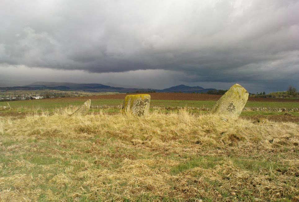
Glenhead Farm standing stones
A few hundred yards south of the large Glenhead Standing Stone, we come across this curious small row of three reasonably large standing stones which — the more you look at them — give the distinct impression that they may be the remains of a large prehistoric tomb. But archaeology records are silent on this matter and we must contend with what we can see. At the northernmost end of the row, a fourth stone lays amongst the vegetation: it may have once stood alone, or maybe been snapped from its fellow monolith. 20 yards south is a large mass of stone; perhaps from an old building, perhaps cairn spoil (does anyone know?)
The local historian Moray Mackay (1984) thought that the line of stones here were once a part of something larger, saying:
“Originally it was probably a circle of six stones, with a seventh in the middle, and this central stone can still be identified by its flat top on which are the mysterious and well known cup-marks, much weathered but plainly visible. Close to the site, urns and stone hammers were unearthed last century.”
Glenhead stone row, looking north
Of the three remaining upright stones, it is the central one which has the cup-markings visible on its top and side (Allen 1882), with a lovely covering of almost luminous lichen giving it extra effect! (a separate TNA Site Entry for the cup-marked stone will be written in due course)
The famous astroarchaeologist Alexander Thom and his son (1990) described the place as,
“A three stone alignment showing about 33° N declination in one direction and 31° S in the other, but the azimuth comes from the stones only and so cannot be accurate. Perhaps the line is lunar to the hill in the SW…”
In Thom’s (1967) earlier work he posited that the alignment may relate to the rising of the star Capella around 1760 BC, but this is untrue. Thom’s error however, was not of his making, but due to the false dates that archaeologists ascribed to megalithic ruins at the time – dates which Thom used in his research, believing that the archaeological fraternity would know what they were talking about! In their collaborated text, Aubrey Burl added how,
“these stones stand on a hill summit at 360ft (110m) OD. The row is on a north-facing slope. Three stones stand. A fourth, prostrate, 6ft 6 in (2m) long, lies against the NE pillar. The row has a NNE-SSW axis. The northernmost stone is 3ft 6in high, the centre 4ft, and the SSW, characteristically the tallest, 6ft 6in… The line is about 27 feet (8.3m) long. The central stone has 23 cupmarks on its top and 4 more on its western side.”
…to be continued…
References:
Allen, J. Romilly, “Notes on some Undescribed Stones with some Cup-Markings in Scotland,” in PSAS 16, 1882.
Burl, Aubrey, From Carnac to Callanish, Yale University Press 1993.
Take the A820 road from Dunblane to Doune. About a mile west of the motorway, keep your eyes peeled for where the small road on your right is signposted to Argaty and Kilbryde. Stop here and walk up the footpath on the left-hand side of the road. A couple of hundred yards up, take the right turn on the track and where the small copse of trees is, go through the gateway, keeping yourself to the left edge of the trees running parallel to the field. About 100 yards or so up, you can’t miss him!
Archaeology & History
Quite a huge fella this one! Standing more than 6 feet high, the monolith is nearly as broad, giving an impression of great size to the old stone. The stone’s nature and date is troublesome: although ostensibly labelled as Bronze Age, alongside the walling which runs down from here we see a great number of other large stones, some of which give the distinct impression of being length of Iron Age walling — but without excavation, its nature remains a puzzle. The monolith stands close to being on top of a rise in the land, which geomancers understand as being important sites of spirit, or places where the dead were rested — but we have no record of any tombs here, so are left with the options of walling or a spirit site.
…and from another angle
On its east-face, the stone has a number of what appear to be curious large cup-markings, but they appear to be little more than the effect of weathering and erosion. There’s also a solid piece of long metal sticking out of the same side, which was obviously done by someone in recent centuries — so maybe a local farmer and his mates stood this one up? Or they were planning on using it as a gatepost…
The site is well worth looking at, best in the winter months when access is easier. It has the feel of other sites close by, hidden from the record books, though probably long gone.
References:
Royal Commission on the Ancient & Historical Monuments Scotland, Stirling – 2 volumes, HMSO: Edinburgh 1963.
Royal Commission on the Ancient & Historical Monuments of Scotland, Archaeological Sites and Monuments of Stirling District, Central Region, Society of Antiquaries of Scotland 1979.
You can come here from either Dunblane to the north, or Bridge of Allan immediately south: either way you reach the site by going along the A9 road until you reach the Lecropt Church, a half-mile north of Bridge of Allan. On the other side of the road is a somewhat battered wooden gate. Go through here and up towards the tree-covered hill, following its edges to the right for a few hundred yards, until you come to another very large mound covered in trees. That’s what you’re looking for!
Archaeology & History
Described on early OS-maps as a “Supposed Roman Camp,” this large fortified stone hillock has more recently been considered a creation of indigenous Scots. Hemmed in and hidden on most sides, by the rises of Knock Hill to the west and Gallows Hill to the east, the only lines of visibility out of the fortress is along a northwest to southeast corridor, keeping the site quite secret to outsiders. It would have been a fine place for a small community in ages not-so-long-ago, keeping the people hidden from the pestilent invasions of both Romans and english in bygone times.
The tree-clad fort, through blizzard
The large raised oval enclosure was walled around its sloping sides and edges, with remains of a walled embankment still visible running around the top of the slopes. What may have been traces of hut circles were on top of the hillock until recent times, but these have been much reduced by some digging near the middle of the site. It would appear that an ‘entrance’ was once visible on the southeastern side of the fort, but when we came here the other day, a lovely blizzard covered the place in snow, so this was difficult to see.
When the Royal Commission chaps came to visit the place in 1979, they didn’t really say much about the place, merely telling of its dimensions, saying:
“This fort measures 48m by 32m within the remains of a single rampart 4.5m thick and 1m high.”
I’m sure there must be much to be said of this lovely old site by local antiquarians, but I haven’t found much as yet. But if you’re wanting a nice quiet spot to sit for a while on the outskirts of Stirling and Dunblane, I’d heartily recommend visiting this place. Badgers and deer also seem to like the place!
References:
Royal Commission on the Ancient & Historical Monuments of Scotland, Archaeological Sites and Monuments of Stirling District, Central Region, Society of Antiquaries of Scotland 1979.
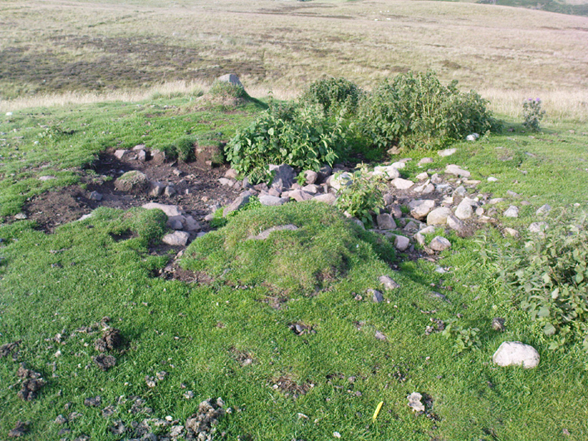
Overgrown Pendreich 2 cairn (Pendreich 1 in background)
Take the same directions to get to the Pendreich 1 cairn. Once on the hilltop, look across the moor a short distance to the north and you can just see this overgrown site a couple of hundred yards away. From Pendreich 1 walk down the grassy slope and then up the gentle ahead of you, till it levels out a bit, keeping your eyes peeled for the change in vegetation and colour that gives the game away!
Archaeology & History
Like its companion cairns — Pendreich 1 & 3 — little has been said of the place. Although much overgrown and visible as a small bumpy grassy mass, with the stones beneath the surface, it’s never been excavated as far as I’m aware. It was referred to in the Scottish Royal Commission inventory for Stirlingshire (1963), site no.4, as ‘Mound, Sheriffmuir Road 1’, in which they wrote:
“Another possible Bronze Age cairn is situated on a low ridge, 200yd N of (Pendreich 1), and at a height of a little over 800ft OD. It is a grass-covered, stony mound which measures 20ft in diameter and stands to a height of 9in above ground level.”
References:
Royal Commission on the Ancient & Historical Monuments Scotland, Stirling – volume 1, HMSO: Edinburgh 1963.
Up, round the back of Stirling University, between Bridge of Allan to Greenloaning, take the steep zigzaggy Sheriffmuir Road uphill, until it levels out beyond the main wooded area where the hills open up on either side of you. There’s a little touristy parking spot further along the road, just below a small wooded bit. Keep going on the road for another ¾-mile, until you reach a small scattered copse of trees on your left. At the top of this copse, walk onto the moor on your left (west), following the old walling for more than another 500 yards, where a scatter of old trees live by the wallside. As this bends back downhill, note the rounded hill less than 100 yards above you (north). Go to the top of it!
Archaeology & History
There are several cairns hereabouts; yet despite several visits here, we still haven’t got round to checking them all out, as other little-known archaeological remains keep catching our attention (old walled structures and a possible enclosure). This is the most notable one of the bunch in the region — and easiest to find thanks to it being on top of the small hill where, many years ago indeed, was laid this small round rocky tomb of some long-dead chief, or granny, or someone!
There’s not been much written about this cairn, or its companions (Pendreich 2 & 3). It was referred to in the Scottish Royal Commission inventory for Stirlingshire (1963) where it’s listed as site no.3 as ‘Cairn, Sheriffmuir Road’, but their description is scant. They wrote:
“On a low ridge 800 yards WSW of spot-level 776 on the Sheriffmuir Road, and at a height of 800ft OD, there is a round cairn measuring 40ft in diameter and 2ft 8in maximum height. For the most part it is covered with grass, but a shallow depression in the centre, which may have been caused by excavation, reveals a few boulders.”
Pendreich cairn, looking westExposed section of cairn
Indeed! This cut into the centre of the cairn is somewhat larger than the 1963 description implies, as one of the images here shows. But the grassy mound is pretty clear and there’s certainly something buried beneath here.
The views from here are excellent and gave the spirits the usual panoramic flights across the land, as at many other ancient tombs. The great pyramidal hill of Dumyat rises to the east; and just a few hundred yards away to the north, we find the long laid-out standing stone of Pendreich Muir, whose mythic history has all-but been forgotten…
References:
Royal Commission on the Ancient & Historical Monuments Scotland, Stirling – volume 1, HMSO: Edinburgh 1963.
Various ways to get here. Probably the easiest is via the golf course itself, walking up towards the top where the trees reach the hills, but keeping your eyes peeled for the large archetypal tumulus or fairy mound near the top of the slope. Alternatively, come up through the wooded slopes from Bridge of Allan and onto the golf course, keeping your eyes ready for the self same mound sat in the corner by the walls. You can’t really miss it to be honest!
Archaeology & History
This is an impressive-looking burial mound sat, intact, on the edge of those painful golf courses that keep growing over our landscape — and you can see for miles from here! It would seem to have been placed with quite deliberate views across the landscape, reaching for countless miles into the Grampian mountains north and west across the moors of Gargunnock and Flanders towards Lomond and beyond…
Fairy Knowe, facing westSir Armstrong’s old drawing
The Fairy Knowe was first excavated in 1868 by Sir J.E. Alexander and his team, when their measurements found it to be some 80 yards in circumference, 78 feet across and 21 feet high — compared to less than 60 feet across and only 8 feet tall today. The findings were recorded in one of the early PSAS reports, and more recently a synopsis of the account was made of it by the Royal Commission (1963) lads who summarized his early findings and told:
“The excavation revealed a cist in the centre of the cairn, laid on the original surface of the ground and measuring 2ft 6in in length, 1ft 6in in breadth and 3ft in depth. Its walls were formed partly of upright slabs and partly of small stones laid horizontally, while the floor and the roof each consisted of a single slab. Within it there was a deposit, 6in in depth, of black earth, charcoal and fragments of human bone among which pieces of a skull were conspicuous. The cist was covered by a heap of large stones, 8ft in diameter and 13ft in height, and this in turn was covered with earth, in which there were charcoal, blackened stones, fragments of human and animal bones and unctuous black earth. Among these remains were found six flint arrowheads, a fragment of what was once thought to be a stone spear-head, and a piece of pine which, it was suggested, might have formed part of a spear-shaft.”
Also, near the top of the cairn in the fairy mound, Sir Alexander’s team located a prehistoric beaker vessel and fragments of what they thought were other beakers pots. Archaeologist Richard Feachem (1977) also mentioned this site in his gazetteer, simply copying the words of previous researchers.
Other prehistoric cairns can be found nearby: one in Cuparlaw Woods less a mile north; plus the Pendreich cairns on the edge of the moors just over 1 mile to the northeast.
Folklore
Obviously an abode of the faerie folk in bygone times, the tales of the place are sadly fading from local memory… Mr Alexander (1868) thought this place may have been an important site for the Pictish folk, and he may well have been correct, as the legendary hill of Dumyat (correctly known as Dun Myat) 2 miles east of here has long been regarded as an outpost of one Pictish tribe.
The main piece of folklore attached to this place relates to its very name and how it came about. In R.M. Menzies (1912) rare work on the folklore of the Ochils, he narrates the local tale that used to be spoken, which describes a procession here from the Fairy Well, just over a mile to the east. Whether this folktale relates to some long lost actual procession between the two sites, we don’t know for sure. Mr Menzies told:
“Once upon a time, when people took life more leisurely, and when the wee folk frequented the glens and hills of Scotland, there was one little fairy whose duty it was to look after certain wells renowned for their curative properties. This fairy was called Blue Jacket, and his favourite haunt was the Fairy Well on the Sheriffmuir Road, where the water was so pure and cool that nobody could pass along without taking a drink of the magic spring. A draught of this water would have such a refreshing effect that the drinker could go on his journey without feeling either thirsty or hungry. Many travellers who had refreshed themselves at the Fairy Well would bless the good little man who kept guard over its purity, and proceed upon their way dreaming of pleasant things all the day long.
“One warm day in June, a Highland drover from the Braes of Rannoch came along with a drove of Highland cattle, which he was taking to Falkirk Tryst, and feeling tired and thirsty he stopped at the Fairy Well, took a good drink of its limpid water, and sat down beside it to rest, while his cattle browsed nearby. The heat was very overpowering, and he fell into a dreamy sleep.
“As he lay enjoying his noonday siesta, Blue Jacket stepped out from among the brackens and approaching the wearied drover, asked him whence he came. The drover said:
“‘I come from the Highland hills beside the Moor of Rannoch; but I have never seen such a wee man as you before. Wha’ may you be?’
“‘Oh,’ said the fairy, ‘I am Blue Jacket, one of the wee folk!’
“‘Ay, ay man, ye have got a blue jacket, right enough; but I’ve never met ony o’ your kind before. Do ye bide here?’
“‘Sometimes; but I am the guardian of the spring from which you have just been drinking.’
“‘Weel, a’ I can say is that it is grand water; there is no’ the likes o’t frae this to Rannoch.’
“‘What’s your name?’ asked the fairy.
“‘They ca’ me Sandy Sinclair, the Piper o’ Rannoch,’ was the reply.
“‘Have you got your pipes?’ asked Blue Jacket.
“‘Aye, my mannie, here they are. Wad ye like a tune? Ye see there’s no’ a piper like me in a’ Perthshire.’
“‘Play away then,’ said Blue Jacket.
“Sandy Sinclair took up his pipes and, blowing up the bag, played a merry Highland reel. When he finished, he was greatly surprised to see above the well a crowd of little folk, like Blue Jacket, dancing to the music he had been playing. As he stopped they clapped their little hands and exclaimed, ‘Well done Sandy! You’re the piper we need.’
“Thereupon Blue Jacket blew a silver whistle, which he took from his belt, and all the wee folk formed themselves into a double row. Blue Jacket then took the Highland piper by the hand, led him to the front of the procession, and told him to play a march. Sandy felt himself unable to resist the command of the fairy, and, putting the chanter into his mouth, blew his hardest and played his best, marching at the head of the long line of little people, who tripped along, keeping time to the strains of the bagpipes. Blue Jacket walked in front of the piper, leading the way in the direction of the Fairy Knowe.
“Sandy Sinclair never marched so proudly as he did that day, and the road, though fairly long, seemed to be no distance at all; the music of the pibroch fired his blood and made him feel as if he was leading his clansmen to battle. When the Fairy Knowe was reached, the wee folk formed themselves into a circle round the little hill, and sang a song the sweetest that ever fell upon the ears of the Highlandman. Blue Jacket once more took his whistle and, blowing three times upon it, held up his hand, and immediately the side of the knoll opened. Bidding the piper to play on, Blue Jacket led the procession into the interior; and when all were inside, the fairies formed themselves into sets, and the piper playing a strathspey, they began dancing with might and main.
“One dance succeeded another, and still Sandy played on, the wee folk tripping it as merrily as ever. All thoughts of Sandy’s drove had gone quite out of his head, and all he thought of now was how best to keep the fairies dancing: he had never seen such nimble dancers, and every motion was so graceful and becoming as made him play his very best to keep the fun going. Sandy Sinclair was in Fairyland, and every other consideration was forgotten.
“Meanwhile his cattle and sheep were following their own sweet will, the only guardian left to take care of them being his collie dog. This faithful animal kept watch as well as he could, and wondered what had become of his master. Towards evening another drover came along with his cattle for the same tryst. He knew the dog at once, and began to pet the animal, saying at the same time, ‘Where’s your master, Oscar? What’s become o’ Sandy?’
“All the dog would do was to wag his bushy tail, and look up with a pleading air, as if to say, ‘I don’t know; will you not find him?’
“‘My puir wee doggie, I wonder what’s come over Sandy? It’s no like him to leave his cattle stravaiging by the roadside. Ay ay man; and at the Fairy Well too! Indeed, this looks unco bad.’
“The newcomer, who was also a Highlander, made up his mind to spend the night with his own drove and that of Sandy Sinclair, thinking that the missing man would turn up in the morning. But when the morning came there was no sign of Sandy.
“Taking Sandy’s collie and leaving his own dog in charge of the combined droves, he said, ‘Find master, Oscar!’ The wise beast sniffed around for a little and then trotted off in the direction taken the day before by Sandy Sinclair and the fairies. By and by they reached the Fairy Knowe; but there was nobody there as far as the drover could see. The dog ran round and round the knoll, barking vigorously all the time, and looking up into the face of the drover as if to say, ‘This is where he is; this is where he is.’ The drover examined every bit of the Fairy Knowe, but there was no trace of Sandy Sinclair. As the drover sat upon the top of the Fairy Knowe, wondering what he should do next, he seemed to hear the sound of distant music. Telling the faithful dog to keep quiet, he listened attentively, and by-and-by made out the sound of the pibroch; but whether it was at a long distance or not, he could not be certain. In the meantime, the dog began to scrape at the side of the mound and whimper in a plaintive manner. Noticing this, the drover put his ear to the ground and listened. There could be no mistake this time: the music of the pibroch came from the centre of the Fairy Knowe.
“‘Bless my soul!’ exclaimed Sandy’s friend. ‘He’s been enticed by the fairies to pipe at their dances. We’ll ne’er see Sandy Sinclair again.’
“It was as true as he said. The Piper of Rannoch never returned to the friends he knew, and the lads and lasses had to get another piper to play their dance music when they wished to spend a happy evening by the shore of the loch. Long, long afterwards, the passers-by often heard the sound of pipe music, muffled and far away, coming from the Fairy Knowe; but the hidden piper was never seen. When long absent friends returned to Rannoch and enquired about Sandy Sinclair, they were told that he had gone to be piper to the wee folk and had never come home again.”
The huge Pendreich Muir monolith, with Dumyat in the background
Nearly 600 yards west of the old Sheriffmuir Road (between Bridge of Allan to Greenloaning), you’re best approaching it up the zigzaggy lane from above Stirling Uni until it levels out beyond the main wooded area where the hills open up on either side of you. There’s a little touristy parking spot further along the road, just below a small wooded bit. Go past this and look out for the small peaked hill nearly a half-mile NW on your left. Take whichever footpath you fancy (if you see one) and get to the top of that hill!
Archaeology & History
This is a wonderful spot, located at the highest point on this small moorland region on the western edge of the Ochil Hills. I haven’t found too much written about this once proud, but now fallen monolith — which seems unusual considering its size, cos it’s huge! It would have stood out and been visible for miles around. Quite when it was felled, I cannot find. The only info I’ve got here (Royal Commission 1963) tells:
“Lying recumbent on a grassy patch among the heather, it is a four-sided pillar measuring 13ft in length, a maximum of 4ft 6in across the wider side, and a maximum of 1ft 6in across the narrower side.”
In enquiring about the nature of this stone a few years ago, a local chap who called himself ‘Wharryburn’ wrote to say, “I believe the laid-out stone is a fallen standing stone. My grandfather was gamekeeper at Airthrey Estate and responsible for the shooting on the moor there he passed it to my father etc… It’s the local volcanic stone, not an ice-dropped erratic. There are also a few biggish stones at points around that I tried to make some sense out of a few years ago, but no luck.”
The great hill of Dumyat rises to its east; a short distance north is a megalithic stone row with its upright Wallace Stone; whilst the overgrown prehistoric cairns of Pendreich 1, 2 and 3 live on the small hillocks a few hundred yards to the south.
References:
Royal Commission on the Ancient & Historical Monuments of Scotland, Stirlingshire – volume 1, HMSO: Edinburgh 1963.
If you’re not into the walk, get the bus running NE between Dunblane and Greenloaning — the A9 — getting off at the Little Chef on the dual carriageway and cross the road, walking up the track to Upper Whiteston Farm (the owners here are very helpful). As you walk up the track you’ll notice the large upright in the edge of the field a coupla hundred yards to your right. That’s the one!
Archaeology & History
This is a mightily impressive site if you’re into yer megaliths! When it was visited and measured by Mr Hutchinson (1893) in the 19th century he found it to be 9ft 4 in tall; and although it seems quite isolated at first sight, we find that there is another large stone companion laid down not far to the north of here which may have had some relationship with it . But that aside… There are also as many as eight cup-markings on the stone’s eastern face: one large one and seven smaller ones, in no particular order as usual! It was these cup-marks that gave me the impression there was once a burial associated with the stone, but the archaeology records seem silent on such a matter; though folklore tradition tells another story…
Folklore
Mr Hutchinson (1893) told that the legend attached to this stone appears to be “of quite recent date.” He said how,
“In the district the stone is known as the MacGregor Stone, and the tradition accounting for the name is to the effect that here a countryman was sacrificed by the followers of Rob Roy, when forming for the engagement on Sheriffmuir, in order to satisfy the ancient Highland superstition that first-blood was an infallible omen of success… The tradition is precise enough to state that a man of the name Dawson was seized in the adjoining hamlet of Whiteheadston (for such is the orignal name) as a whig, and therefore a foeman and proper victim. Dawson, however, suspecting the intentions of the captors, vehemently professed himself a supporter of King James and was left off. But another inhabitant of the hamlet not so acute or not so hypocritical, was immolated at the stone.”
Hutchinson however, doubts the accuracy of the tale and suggests that the local name of the MacGregor’s Stone derives from the fact that the monolith stands upon land once owned by the MacGregors of Balhaldies, countenancing that the stone “is of much earlier date than the MacGregors of Balhaldie or any other sept of the Children of the Mist.” I think he’s got a point!
References:
Hutchinson, A.F., “The Standing Stones of Stirling District,” in The Stirling Antiquary, volume 1, 1893.