If you wish to find it park the car at the church and follow the footpath beside the church and after crossing the stream and style turn right and continue along the woods passing the information centre (where a wooden box holds maps) and then after a few feet one reaches a small clearing and a path leads to the right into the woods. Take this and this will lead to the well.
Archaeology & History
The origin of the name ‘Knapwell’ is unclear: Cnapa may be the name of the first settler, or simply ‘boy’ ‘moneylender’ or even ‘mound’ referring to the earthworks to the end of the present village. The site is doubtless ancient and probably pre-Christian origin. Interestingly, one wonders whether the boy meaning is the correct one considering another Cambridgeshire site, the Barnwell on the outskirts of Cambridge has the same suggested origin. It may suggest that the local tribes here perhaps washed their infants in its water in a ritual fashion. There is some evidence of wells associated with ritual washing in other locales so it is possible. Knapwell is first mentioned in a will by A.D. 1000, and the settlement is noted in the Domesday Book of 1086 as Chenewelle, being held by Abbot of St Benedict of Ramsey. However, this was the estate not the well so nothing should be implied from Ramsey Abbey’s ownership.
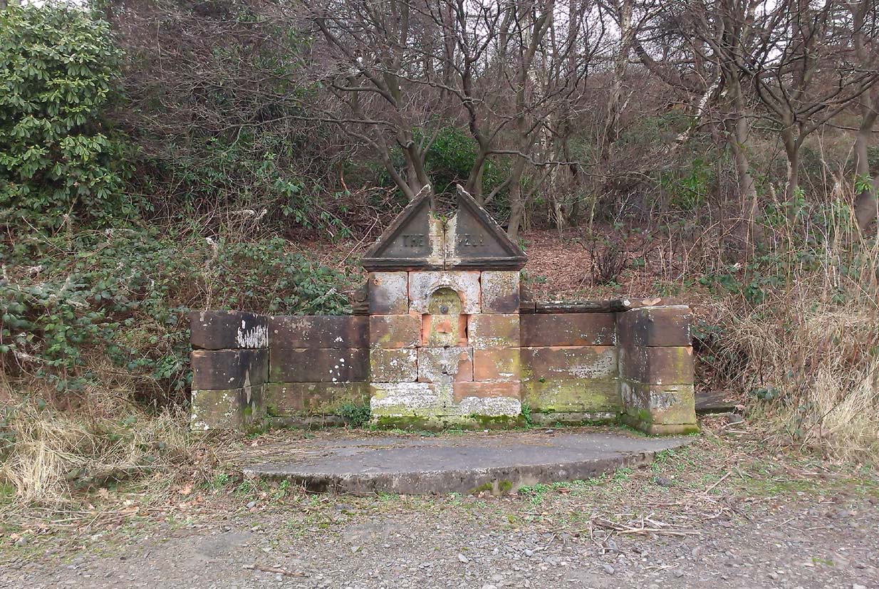
The spring produces copious but sluggish red water and is protected by a red brick domed or arched well house similar to those of Holywell and Longstanton. When I visited the well is in fear of collapsing, and had deteriorated over a number of years, but recent pictures suggest it is in better condition.
Folklore
The well was the sole source of freshwater for both Boxgrove and Knapwell parishes and footpaths still lead from both communities to the well. Knapwell was also known as Little Wellesworth indicating the importance of this and The Victoria County History notes for Knapwell:
‘..named from the chalybeate Red Well, supposedly medicinal, in Boxworth Wood just east of the village.’
Like many Chalybeate springs, healing traditions are attached to it but curiously no details are recorded.
The water was well thought of well into the 20th century, for the Parish guidebook, KNAPWELL VILLAGE And The Parish Church of All Saints (1978) notes:
“Within living memory a drinking cup used to hang on the small brick arch over the spot where the spring rises.”
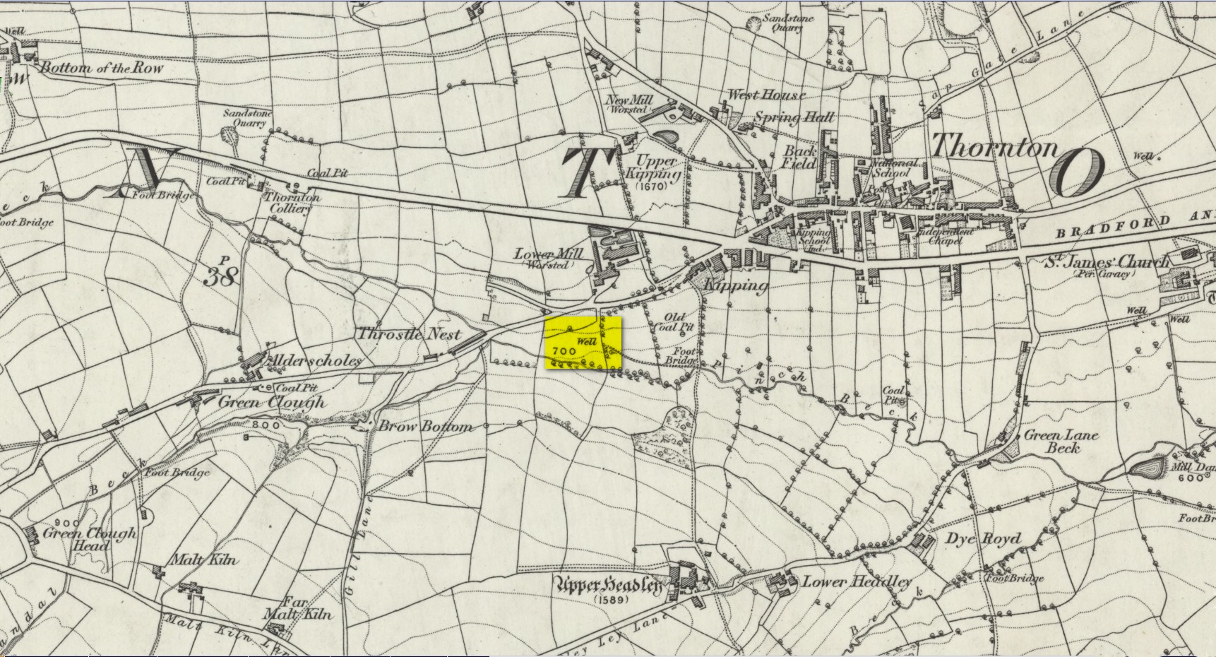
Another well with considerable supernatural renown was this little-known site near the old village of Thornton, on the western outskirts of Bradford. We’re not 100% sure about its exact location, but the grid-reference cited here is of an old ‘Well’ that was highlighted on the first Ordnance Survey map of the region, at the end of solitary path which led to it and nowhere else. Our only documentary information comes from Elizabeth’s Southwart’s (1932) fine old book on the folk life of the old village, as it once was. At a place once known as Bent Ing Bottom, just south of the old village, is where it used to be known. The name of this Well is also curious, as no historian has yet worked out who the ‘Jim Craven’ was, nor what his relationship to the site might have been. It’s the folklore of it, however, which brings it the attention it deserves.
Folklore
In Elizabeth Southwart’s (1923) work, she told us that the place once known as “Bent Ing Bottoms have lost their romance.” She continued:
“Whether the golfers have driven it away—for the fields now form part of the Thornton Golf Links—or whether the advance of modernity in other forms is to blame, it is difficult to say. Once they were the haunts of “Peggy-Wi-T’-Lantern” and the Bloody-tongue. Peggy, a dame in a white mob cap, kilted skirt and white stockings, walked about with a lantern, enticing the unwary traveller to his doom. She was given to wandering, for, they say, Jim Craven Well, half a mile away, was a place to be avoided after nightfall.
“The Bloody-tongue was a great dog, with staring red eyes, a tail as big as the branch of a tree, and a lolling tongue that dripped blood. When he drank from the beck (known as the Pinch Beck, PB) the water ran red right past the bridge, and away down—down—nearly to Bradford town. As soon as it was quite dark he would lope up the narrow flagged causeway to the cottage at the top of Bent Ing on the north side, give one deep bark, then the woman who lived there would come out and feed him. What he ate we never knew, but I can bear testimony to the delicious taste of the toffee she made.
“When the dark was coming we used to sit on the filled-in pit, which makes a hump in the middle of the field, and wait for him. The sun would sink redly, through the arches of the viaduct, the trees that lined the beck would grow an ever darker green until they became black, the beck would begin to gurgle and gulp in a queer way; and down in the hollow we would hear a whimper, a whine, a moan, a snarl. Then, with scalps and spines playing queer tricks, we would wait and wait. But none of our little band ever saw him, except one girl, and she saw him every time.
“One Saturday a girl who lived at Headley came to a birthday party in the village, and was persuaded to stay to the end by her friends, who promised to see her ‘a-gaiterds’ if she would. As soon as the party was over the brave little group started out. But when they reached the end of the passage which leads to the fields, and gazed into the black well, at the bottom of which lurked the Bloody-tongue, one of them suggested that Mary should go alone, and they would wait there to see if anything happened to her.
“Mary was reluctant, but had no choice in the matter, for go home she must. They waited, according to promise, listening to her footsteps on the path, and occasionally shouting into the darkness:
““Are you all right, Mary?”
““Ay!” would come the response.
“And well was it for Mary that the Gytrash had business elsewhere that night, for her friends confess now that at the first sound of a scream they would have fled back to lights and home.
“We wonder sometimes if the Booody-tongue were not better than his reputation, for he lived there many years and there was never a single case known of man, woman or child who got a bite from his teeth, or a scratch from his claws. Now he is gone, nobody knows whither, though there have been rumours that he has been seen wandering disconsolately along Egypt Road, whimpering quietly to himself, creeping into the shadows when a human being approached, and, when a lantern was flashed on him, giving one sad, reproachful glance from his red eyes before he vanished from sight.”
Southwart later tells us that the ghostly dog travelled into the north and vanished. From the description she gives of the children walking their friend to “the end of the passage which leads to the fields, and gazed into the black well, at the bottom of which lurked the Bloody-tongue,” I can only surmise that the solitary well shown on the very first OS-map of Thornton at the coordinate given above is the place in question.
The ‘Bloody Tongue’ is first mentioned in Yorkshire folklore, I think, by Roger Storrs, in his article on holy wells in 1888, where he tells it to be one of the mysterious beings that live, usually at the bottom of the waters and almost universally used “to deter children from playing in dangerous proximity to a well.”
From the description of the waters turning red when the ghostly dog drank from it, we have a mythic account of when the waters occasionally turned red from the iron-bearing waters (chalybeate) which, obviously, wasn’t like this at all times. Whether this was a sporadic, unpredictable flow of iron in the waters, or a cyclical pattern of the water-flows, we are not told (which would imply, moreso, that it was sporadic). The folklore about this ghost and its appearance with another elemental creature along an old straight track running north from Upper Headley Hall to Thornton is intriguing—as in many old pre-christian traditions, North is the airt, or direction, representing Death; and black dogs are traditionally guardians of underworld treasures in the land of the Dead. With the plethora of other animistic folktales once known in this district (boggarts or goblins were known in nearby woods, wells and farms) it is likely that the origin of such folklore dates way back into antiquity.
References:
Bennett, Paul, Ancient and Holy Wells of West Yorkshire, forthcoming
Southwart, Elizabeth, Bronte Moors and Villages: From Thornton to Haworth, John Lane Bodley Head: London 1923.
Storrs, Roger, ‘Legends and Traditions of Wells,’ in Yorkshire Folk-lore Journal – volume 1 (ed. J. Horsfall Turner) 1888.
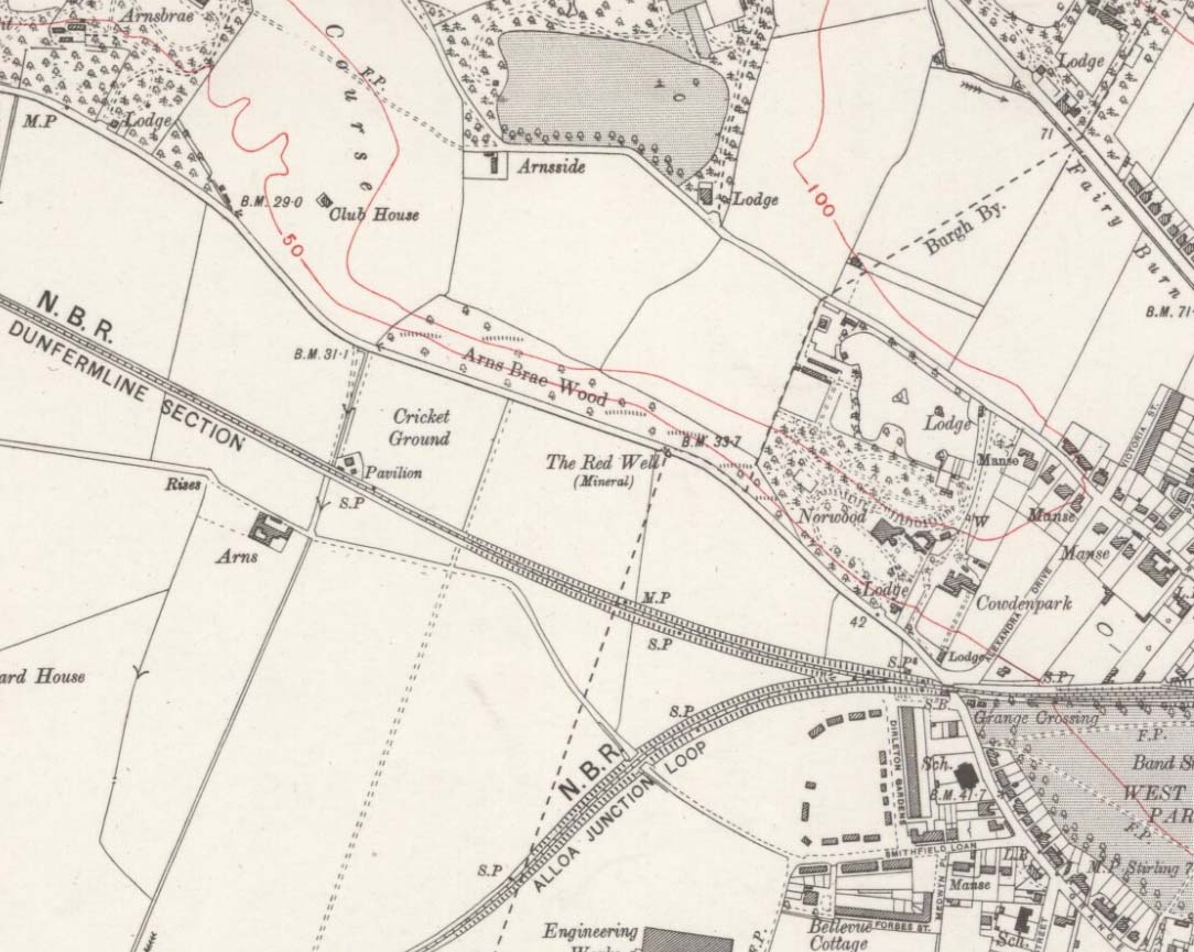
Along the A907 a mile west of Alloa and heading towards Tullibody, just before the roundabout across the road from the school fields, a small entrance takes you into the small wooded parkland. There, right in front of you as you walk in, and visible from the road, is the enclosed architectural stone walling and somewhat ruinous remains that are the Red Well, with its faded name carved on top.
Archaeology & History
Red Well on 1913 map
Although the waters no longer run for the people to drink, this old iron-bearing spring was long of repute to the old folk of eastern Alloa. So much so, it seems, that even Janet & Colin Bord (1985) included it in their national survey of sacred wells! Like other chalybeate springs, its waters were known to be good as a tonic—which makes sense as iron fortifies the blood and general immune system. The Well was highlighted on the 1913 OS-map of the area.
References:
Bord, Janet & Colin, Sacred Waters, Granada: London 1985.
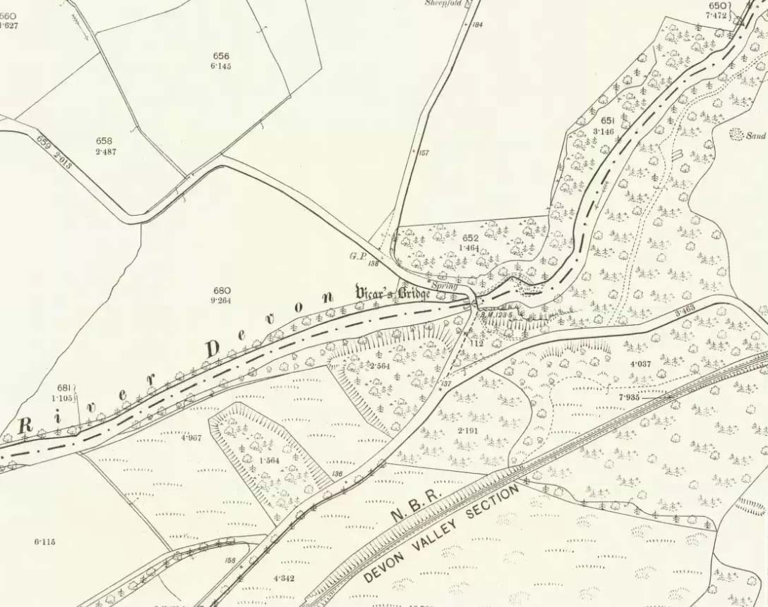
Somewhere hiding away above the north-side of the River Devon, just above the Vicar’s Bridge, a little-known healing well came into being following industrial workings in the glen in 1831 by a local iron-working company. The waters were strongly chalybeate, or iron-bearing—and as the fad amongst the wealthy was, at the time, a love of Spa Wells, this mineral spring was broadcast as a competitor of the Harrogate and Bath Spas. But it failed pretty fast, sadly.
Bottles of the water were marketed and sold as ‘Dollar Mineral Water’ in many of the large cities, but sales weren’t too good. Johnston & Tullis (2003) pointed out how the waters would have been coloured like brandy; and despite it being good for anaemia, a good tonic, and favourable in treating cuts and bruises, the mineral spring was no longer of any value as a business, dying a quick death. Local people still kept using the waters, but in recent years the spring appears to have died too.
References:
Johnston, Tom & Tullis, Ramsay (eds.), Muckhart, Clackmannanshire: An Illustrated History of the Parish, MGAS 2003.
Healing Well (destroyed): OS Grid Reference – NT 314 735
Archaeology & History
This was one of two medicinal springs that could once be found in old Portobello village. Like its companion Chalybeate Well nearly a mile northwest, in the early 19th century those entrepreneurial types tried fashioning these waters into being a Spa Well. It didn’t really work and the fad passed after just a couple of decades—and soon after the local people had completely lost their water supply here. The best historical account of it is in William Baird’s (1898) magnum opus on Portobello. He told how the well,
“was, at the beginning of the century, situated in a garden near to the main road, where there was a well with drinking cups for the accommodation of visitors, a small sum being charged from those using it. The supply here having in some way become interrupted the spring was neglected for a time. It found vent, however, lower down and nearer to the Promenade at the foot of Joppa Lane. About fifty years ago there was a pretty large open basin, in the centre of which the water bubbled up about half a foot. It was of a red brick colour. Unfortunately on the starting of a pump on the Niddrie Bum to drain the water from the Niddrie coal pits, the supply of water was again interrupted, and this excellent mineral spring, which was strongly impregnated with oxide of iron and sulphate of lime and magnesia, ceased to flow with its former fulness.”
In 1869, the Industrialists dug into the Earth to construct their promenade and, after countless centuries, the waters of this old medicinal well finally died and fell back into the deep Earth…
Take the Heptonstall road up from Hebden Bridge, going round the village (not into it) and head through Slack and onto Colden. Just as the road begins to go downhill to Colden, note the small single-track road on your right called Edge Road. Go on here for a good mile until it becomes a dirt-track and there, on your left, is the half-run-down old farmhouse called New Edge. Just yards past it, off to the right by the trackside, you’ll see this large copper-coloured stone basin oozing with the same-coloured liquid.
Archaeology & History
New Edge Chalybeate, above Colden
This is one of what Thomas Short (1724) called “the ten thousand chalybeats”, or iron-bearing springs, inhabiting the Yorkshire uplands — but he didn’t include this site in his huge survey. But it’s a beauty amongst chalybeates, as a visit here clearly shows! The well is one of two found on either side of the old building known as New Edge (as contrasted with Old Edge, a little further along the lane), and its waters trickle gently from the old stone trough.
The waters are undoubtedly enriched with large amounts of iron, as the photo here shows, giving the waters clear medicinal value. In tasting them, not only do the waters give you that copper-coloured hue, but you can clearly taste the minerals in the water. As with other iron-bearing springs, the water from the New Edge spring is good for the blood, good for anæmia, loss of energy and a low immune system.
References:
Short, Thomas, The Natural, Experimental and Medicinal History of the Mineral Waters of Derbyshire, Lincolnshire and Yorkshire, privately printed: London 1734.
Walk from Ilkley up the Wells Roads as if you’re going to the White Wells, but keep following the road along, keeping to the moorside (don’t go up Panorama Drive). A few hundred yards up, crossing the small bridge over the gorse-scattered stream, take the footpath to your right and walk along the moor-bottom, parallel to the rich houses. Keep walking, past the reservoir (don’t go up the slope on the newly created path) and cross the small wooden bridge. Once over the other side, head through the gate and walk along the rocky footpath into the woods. Less than 100 yards down where the first seat is, there’s a slow-running blood of water oozing out from the rocks.
Archaeology & History
At the top of this bit of old woodland, out of rocks near the top of the trees, emerges another of Yorkshire thousands of chalybeates, or iron-bearing springs of water, on the very edge of Ilkley Moor. Collyer and Turner (1885) mentioned its discovery in 1883, but gave no further details. Searching for this place on one of my countless moorland ambles as a child, I found its waters oozing slowly from betwixt moss-enriched rocks on the west side of the stream. If you look for it in the dry season though, there is little to see. It is best seen later in the year, after heavy rains, although the waters are pretty slow running and have that distinct “off” taste (an attribute well-known of chalybeates —taste ‘em and see!). The only real account of this little-known healing well was told in an early edition of the Leeds Mercury (1883), shortly after its rediscovery, in which we were told:
“Our Ilkley correspondent says the existence of a chalybeate spring has lately been discovered there, and from its valuable medicinal properties will prove a valuable adjunct in the future development of this health resort. The water from the spring (which is situated near to the Panorama Rocks, in what is known as Hebers Gill, or Briery Wood) has been submitted to Mr F.M. Rimmington…of Bradford for analysis and his report is of a most favourable character. The data shows that the water is remarkable for the smallness of the amount of its saline constituents, and (so far as the analyst has been able to discover by reference to published analysis of either English or Continental chalybeate springs), there is not one comparable to it: whilst its ferruginous element is equal to the majority of such waters and, in Mr Remmington’s opinion, as large as is desirable for medicinal effect. The spa that most resembles the one under notice is that of Tunbridge Wells in Kent, which is derived from exactly the same geological formation (millstone grit), the total solid constituents of this water being 13½ grains to the gallon. The report adds that, “The use of this class of waters as medical agents has, from remote periods, been found efficacious in those states of debility denominated anemia,” and “the value of this class of spa water as a safe and natural remedy can scarcely be overestimated.” From the foregoing it will be seen that an important discovery has been made…”
This once important spring of water — that would have been known and used by our prehistoric ancestors living on the moors above — is nowadays but a shadow of its former self. The water tables drop annually as a result of moorland drainage and other poor land management and we only see a small trickle of water emerging from the mossy rocks these days…
…to be continued…
References:
Anonymous, “Important Discovery at Ilkley,” in Leeds Mercury, August 18, 1883.
Bennett, Paul, Healing Wells and Springs of Ilkley Moor, unpublished: Hebden Bridge 1995.
Collyer, Robert & Turner, J.H., Ilkley: Ancient and Modern, William Walker: Otley 1885.