Woofa Bank (352), Burley Moor, West Yorkshire

Cup-and-Ring Stone:  OS Grid Reference – SE 13611 45616

Also Known as:

  1. Carving no.183 (Hedges)

Getting Here

Deep cups on this Woofa Bank carving

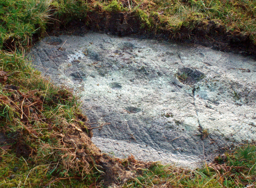
Follow the same directions as if you’re gonna visit the Idol Stone carving.  From here, keep walking uphill until your reach the rocky crags on the slope above.  Go left (southeast) along the small footpath that runs along the top of this ridge for 350 yards (320m) and, where the path begins to very gradually slope back downhill a little, go sharp left, downhill for 50 yards, where a couple of large rocks stand out. Before one of these, low down in the heather, you’ll find this curious cup-and-ring stone.

Archaeology & History

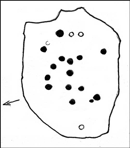
This is a lovely cup-and-ring stone, seemingly recorded for the first time by fellow rock-art student Stuart Feather (Radford 1968) in one of his numerous ramblings over these moors.  It’s a difficult habit to break once the bug bites!  The rock itself is unusual, possessed of undulating geophysical waves or ripples across its surface, similar to a cluster of others a couple of miles west near the very top of Rombald’s Moor.  The curvaceous feature alone would have given this stone a spirit-nature of its own, different from the others in this area — though we may never know what that might have been.

Primary design (after Hedges)

The cups carved onto this rock are cut much deeper than most other prehistoric carvings along this ridge and, for some reason or other, give an immediate impression of having been painted and coloured in lichens or other natural dyes, to encourage or awaken the mythic history within and around the stone.  It’s a formula that occurs worldwide and needs serious consideration, not just here, but at many other outcrop carvings in Wharfedale and much further afield.

The carving was described in John Hedges’ (1986) fine survey as a,

“Fairly small flat rock, level with the ground, sloping slightly in heather and crowberry, its surface layered in waves which appear to have been incorporated in the design which covers the rock.  About 25 cups, some very deep and some showing pick marks, three are enclosed in rings, one of which has three cups in its circumference and a groove leading from it to edge of rock.”

Many other carvings scatter the moorland plain of Woofa Bank — some recorded, others not — in a region rich in Bronze Age and probably earlier cairns. We’ll add all their profiles here as time floats by…

References:

  1. Bennett, Paul, Of Cups and Rings and Things, unpublished: Shipley 1981.
  2. Boughey, Keith & Vickerman, E.A., Prehistoric Rock Art of the West Riding, WYAS: Wakefield 2003.
  3. Hedges, John (ed.), The Carved Rocks on Rombalds Moor, WYMCC: Wakefield 1986.
  4. Radley, J. (ed.), “Yorkshire Archaeological Register, 1968,” in Yorkshire Archaeological Journal, volume 42: part 166, 1968.

© Paul Bennett, The Northern Antiquarian


Buried Stone, Burley Moor, West Yorkshire

Cup-Marked Stone:  OS Grid Reference – SE 1380 4521

Archaeology & History

Buried Stone carving

One of this regions many simple cup-marked stones, this example is another that is not in the archaeological records as it was rediscovered on March 1, 2012, by one-time rock art student, Michala Potts of Keighley.  Found in association with one of the many prehistoric cairns in the landscape, it is a small flat rock, that was mainly covered over in dead bracken remains.  There are two very distinct archetypal cup-marks etched on the westernmost half of the stone, with a possible faint third in-between the two.  The larger of the two cups measures 2 inches across and is a half-inch deep; the other cup being 1½ inch across and roughly the same depth. Several other cup-and-ring stones can be found close by.

Buried Stone, when dry

The curious-looking inverted ‘F’ beneath the two cups is somewhat of a dilemma, as part of it appears to have been carved and has the hallmark of a typical boundary marker. However, the top line is almost certainly a natural feature on the rock, but the vertical and second horizontal line may have been cut into the rock at a later date.  There are remains of some medieval workings just 10 yards away from this stone, which may account for the enhanced lines; but we could do with a decent geologist to have a look and tell us one way or the other!

…to be continued…

© Paul Bennett, The Northern Antiquarian


Dyke Stone, Burley Moor, West Yorkshire

Cup-Marked Stone:  OS Grid Reference –  SE 1395 4517

Getting Here

Sketch of the main design

Once you’re on Ilkley moorland itself, head over to the Little Skirtful of Stones giant cairn.  From here, walk due east for 115 yards where you’ll come across an overgrown dried-up (usually) dyke cut into the heath, which runs roughly north-south.  Walk over the dyke onto its eastern side and just a few yards in front of you, in a slight dip, you’ll found a female oval-shaped boulder amidst the heather.

Archaeology & History

Rediscovered on Tuesday March 6, 2012, this medium-sized rounded (female) rock has somehow evaded all previous archaeological evaluations.  It is one of at least five previously unrecorded cup-marked stones found close to each other on the eastern section of Rombald’s Moor near the Little Skirtful of Stones.  The rock measures roughly 2 yards by 1½ yards and possesses at least 15 cup-marks that cover most of its surface.  Each cup-mark averages about 2 inches across and are less than ½-inch deep.  There is a natural ‘bowl’ in the southern section of the rock with a typical cup-mark in it and a smaller one in close association.

Dyke Stone cupmarks
and from another angle

The other cup-markings found close by, appear to be associated with the prehistoric cairns but this stone — the largest of the group — lacks any immediate relationship with such monuments.  Further ground explorations are required at other potential spots close by; plus we could do with getting back here when the sunlight’s better, so we can get some clearer photos!

© Paul Bennett, The Northern Antiquarian


Corrycharmaig (1), Glen Lochay, Killin, Perthshire

Cup-Marked Stone:  OS Grid Reference – NN 52794 35503

Also Known as:

  1. Allt Coire Charmaig
  2. Canmore ID 24163

Getting Here

Corrycharmaig 1 stone

Go thru Killin and, just past the Bridge of Lochay hotel, take the tiny road on your left.  Go down here for 3 miles till you pass the gorgeous Stag Cottage (with its superb cup-and-rings in the field across the road) for another 300 yards, until you see Duncroisk Farmhouse set back on your right.  On the other side of the road, go thru the giant deer-gates (close ‘em behind you) to the river-bridge and across it.  Walk along the track till you reach the turning to Corrycharmaig House on the right (over the stream), but here, go up into the field thru the gate.  Walk up the hill ahead of you with its trees on the left, walking up onto the grassy level, over the deer-fence, then up again to the rounded knoll another 100 yards up.  You’re here!

Archaeology & History

On my first visit to this stone, in overcast and wet conditions — the easternmost of at least four separate carved rock faces along the same geological ridge — I only noticed a handful of cup-marks etched onto the northeastern section of the stone. But I was sure there were supposed to be more.  And when I returned home to check up, found that Ron Morris (1981) said there were “40 widely scattered cups of which, however, 29 well-defined cups are in a compact group, of which 6 are in a line.”  Much more than what I saw! And when I checked further, it was evident that even more cup-marks were once visible on the rock.  In the very first description of this carved stone, E.A. Cormack (1952) told:

“On the easterly area there are about 70 small cups, roughly one inch in diameter, in groups of ten to twelve. Most are on the flatter rock surface, but some are on the steeper slope facing south, which also bears the marks of deep glacial scorings.”

A sample of cups on ‘Corrycharmaig 1’

So on our visit here again a few weeks ago when we stayed at Corrycharmaig house*, a couple more visits allowed a slightly better investigation, albeit in even wetter and cloudier conditions than our first visit!  And the more we looked, the more we could see; and it was plainly evident that a number of cup-marks had become receptacles for moss-growth!  We counted at least 40 cup-markings on this ‘Corrycharmaig 1’ stone, but it seemed pretty obvious that beneath the grasses and vegetation, more carvings would be found.

Walking SSE along the same rocky ridge brings you to the other rock faces of Corrycharmaig (2), (3) and (4) — all with their own carvings.  Corrycharmaig 2 possessing the only known complete cup-and-ring on the ridge.  More carvings remain hidden nearby…

References:

  1. Cormack, E.A., “Cross-Markings and Cup-Markings at Duncroisk, Glen Lochay,” in Proceedings of the Society of Antiquaries, Scotland, volume 84, 1952.
  2. Morris, Ronald W.B., The Prehistoric Rock Art of Southern Scotland, BAR 86: Oxford 1981.
  3. Royal Commission on the Ancient & Historical Monuments of Scotland, Archaeological Sites and Monuments of Stirling District, Central Region, Society of Antiquaries of Scotland 1979.

© Paul Bennett, The Northern Antiquarian


Duncroisk 6, Glen Lochay, Killin, Perthshire

Cup-Marked Stone:  OS Grid Reference – NN 53466 36485

Getting Here

Position of ‘Duncroisk 6’ cup-marked stone

Follow the same directions to reach the Duncroisk Crosses stone.  From here, look up the slope to your right and you’ll see the line of fencing running uphill.  Follow this until you reach the ruined remains of the old sheepfold building.  From here, look towards the tree-lined gorge of Duncroisk Burn, a few hundred yards west and walk towards it for about 50-60 yards.  There’s a group of three rocks hereby, two are large, but the carving’s on the smallest one in the middle.

Archaeology & History

This cup-marked stone was rediscovered as a result of the fine archaeological survey work by that Glasgow bunch of Certified Field Archaeologists, in their assessment of remains in and around Duncroisk Farm.  As well as mentioning — albeit briefly — the carvings of Duncroisk Farm and Duncroisk Crosses, Dugald MacInnes (2001) and his team came across another that hadn’t been recorded before.  Described in their survey as ‘feature 2’, he told,

“Some 20 metres downslope from the sheep fank and about 60 metres NW from it, there is a group of large boulders.  On the southeast sloping face of one of these there are three previously unrecorded cup-marks.  These are oriented vertically on a northeast to southwest alignment and are no more than 4cm apart.  They are all about 7cm in diameter and 2.5cm deep.”

The carved rock is a relatively small one sitting roughly in between two much larger rocks, both of which are easily visible from the Duncroisk Crosses stone less than 100 yards down the slope.  It’s probably only gonna be of interest to the rock-art purists among you and some may even question its veracity, particularly the bottom of the three cups, which gives the impression of being unfinished.  If you visit the site in summer and autumn it will be much harder to find, as it gets overgrown with bracken. (we did take a number of photos of this stone, but managed to somehow delete them all before saving to disk – so have gotta check it again when we next visit here)

References:

  1. MacInnes, Dugald, An Archaeological Field Survey of a Deserted Settlement at Duncroisk Farm, Glen Lochay, Association of Certified Field Archaeologists: Glasgow 2001.

© Paul Bennett, The Northern Antiquarian


Corrycharmaig (4), Glen Lochay, Killin, Perthshire

Cup-Marked Stone:  OS Grid Reference – NN 52768 35504

Getting Here

‘Corrycharmaig 4’ cup-marked stone

Follow the same directions to get to the Corrycharmaig 3 carving; and just a yard or two to the right of the far western edge of the rock, you’ll see another smaller slightly sloping rock, closer to the fencing, with faint cup-markings.  That’s the one! (note that the 10-figure grid reference given here might need adjusting slightly)

Archaeology & History

This small slightly sloping piece of exposed rock is on the western extremity of the Corrycharmaig cluster of carvings, but is a distinctly separate piece of rock from the Corrycharmaig 3 stone (though part of the same outcrop).  The stone itself has two sections to it, with a natural crack in the rock defining eastern and western section — both of which possess cup-marks.

The easternmost section of the stone has seven cup-marks, some of which were only recently uncovered.  A large single cup-mark sits near the middle of this portion of the rock; this is probably what Mr Cormack (1952) was talking about when he told that, “further west (of the Corrycharmaig 3 carving, PB) is one isolated larger cup of 4-inch diameter.”  On the western side of the stone, we find just two or three cup-marks, though one large cup-marking here would seem to be Nature’s handiwork.

It is highly likely that beneath the excessive vegetational growth around this carving and others along this ridge, other sections of prehistoric carvings remain to be found.

References:

  1. Cormack, E.A., “Cross-Markings and Cup-Markings at Duncroisk, Glen Lochay,” in Proceedings of the Society of Antiquaries, Scotland, volume 84, 1952.
  2. Morris, Ronald W.B., The Prehistoric Rock Art of Southern Scotland, BAR 86: Oxford 1981.
  3. Royal Commission on the Ancient & Historical Monuments of Scotland, Archaeological Sites and Monuments of Stirling District, Central Region, Society of Antiquaries of Scotland 1979.

© Paul Bennnett, The Northern Antiquarian


Withgill Cross, Great Mitton, Lancashire

Cross:  OS Grid Reference – SD 7060 4062

Getting Here

Withgill cross location (after QDanT)

From Great Mitton village, go up (north) the slightly winding B6243 road for a mile, then take the left turn up the minor country lane, for about 300 yards, till you reach a tiny crossroad of tracks, one leading down to Scott House and the other up to Withgill Farm.  Stop here!  You’re damn close.  From what our man ‘QDanT’ says, this is now to be found behind the hedge by the roadside, on the side of the road where the track runs up to Withgill Farm, tucked low and overgrown close to the ground.  Good luck!

Archaeology & History

Described by Mr Ackerley (1947) as being found

“in the coppice beside the gate to Withgill is the base of another road-side cross,”

Cross-base (after QDanT)

all but overgrown by ivy and lost to the causal eye.  Thankfully our man Danny got on his bike and found the remains of the little fella, all-but invisible beneath the vegetative growth!  Beneath the vegetation, John Dixon told there to be “some interesting 17th century graffiti,” but there’s not much that remains of the old cross.

Folklore

There is a curious story about a legendary church that was once supposed to have been up the track on the hill just above here at the farm.  The story goes,

“that when Mitton church was built, it ought to have been built on Withgill Knowle: that there was a church somewhere about there, and that the stones from it were carted down to Mitton in one night and used in building the present church.”

This bitta folklore is a motif found commonly at prehistoric sites, where stones from our ancient places were uprooted and moved (destroyed) to give way to the new christian mythos.  To my knowledge, no such prehistoric sites are known hereby.  Mr Dixon – over to you dear sir!

References:

  1. Ackerley, Frederick George, A History of the Parish of Mitton in the West Riding of Yorkshire, Aberdeen University Press 1947.

Links:

  1. Pictorial Journey of East Lancashire Crosses
  2. Teddy’s Exploration of the Withgill Cross Base

© Paul Bennett, The Northern Antiquarian


Corrycharmaig (3), Glen Lochay, Killin, Perthshire

Cup-Marked Stone:  OS Grid Reference – NN 52774 35504

Also Known as:

  1. Allt Coire Charmaig

Getting Here

Corrycharmaig 3 stone, with Meall Dhuin Croisg rising…

Go thru Killin and, just past the Bridge of Lochay hotel, take the tiny road on your left.  Go down here for 3 miles till you pass the gorgeous Stag Cottage (with its superb cup-and-rings in the field across the road) for another 300 yards, until you see Duncroisk Farmhouse set back on your right.  On the other side of the road, go thru the giant deer-gates (close ’em behind you) to the river-bridge and across it.  Walk along the track till you reach the turning to Corrycharmaig House on the right (over the stream), but here, go up into the field thru the gate.  Walk up the hill ahead of you with its trees on the left, walking up onto the grassy level, then up again to the rounded knoll another 100 yards up.  You’re here!

Archaeology & History

This is the most visually impressive of the set of four cup-marked rocks along this ridge — although if you visit here when the light is poor, or the sky’s overcast, you’ll be lucky if you can actually see much of the material.  For example, I counted 38 cups on this particular stone on a day when the sky was bright, but upon checking later, found that Mr Morris (1981) described there being, “40 widely scattered cups of which, however, 29 well-defined cups are in a compact group of which 6 are in line.”  Whereas more recently the Canmore website told there to be,

Corrycharmaig-3 carving
Close-up of line of cups

“At least 48 cupmarks are visible on the most westerly exposure. The cupmarks range in size from 25mm in diameter and 5mm in depth to 100mm in diameter and 40mm in depth.  A straight line of six cupmarks arranged close together is orientated running from NW to SE.”

This line of six cups is very distinct and stands out as the most notable aspect on this carving, probably because it gives a sense of ‘order’ or linearity, whereas the rest of the carving (as with oh so many of them, thankfully) possess that non-linear feature of scattered cups and lines, dissolving reason and ego, and eliciting the natural meditative state, if one so cares to allow. On our most recent visit here, our eyes and fingers traced what appeared to be the faint remains of a carved line running along the bottom edge of the row of cups and then bending around the bottom cup in the same line — a little bit like the carved lines which run around the edges of the row of cups on Ilkley Moor’s Idol Stone.  You can just make this ‘line’ out in the photo, below.

Cup-mark and flint
Clusters of cups and faint line

On one visit to the site when we’d stayed with the late great Lindsay Campbell of Stag Cottage, other sections of this carving were visible that we’d previously missed, highlighting at least 45 cup-marks that we counted.  Several of the cups had been exposed by animals (sheep or deer – we couldn’t tell) cutting into the soaking wet earth and in carefully checking a couple of cups whose edges were exposed, found a small worked flint within one of the cups!  I looked at it, held it, puzzled over it, then laid it back where we’d found it.  You can see it in the photo here, on the right.

This carving obviously grows on you with time.  And like its carved companions of Corrycharmaig (1), (2) and (4) both left and right of here, the stone rests within a natural theatre of dreams, eliciting — if only in a slight way — the non-focal perspective necessary to receive the carvings as its executor knew…

References:

  1. Cormack, E.A., “Cross-Markings and Cup-Markings at Duncroisk, Glen Lochay,” in Proceedings of the Society of Antiquaries, Scotland, volume 84, 1952.
  2. Morris, Ronald W.B., The Prehistoric Rock Art of Southern Scotland, BAR 86: Oxford 1981.
  3. Royal Commission on the Ancient & Historical Monuments of Scotland, Archaeological Sites and Monuments of Stirling District, Central Region, Society of Antiquaries of Scotland 1979.

© Paul Bennett, The Northern Antiquarian


Springfield Cursus, Chelmsford, Essex

Cursus Monument (destroyed):  OS Grid Reference – TL 735 084

Also Known as:

  1. Springfield Barnes Cursus

Archaeology & History

The first cursus monument discovered in Essex, archaeologists were fortunate when they came to excavate the site in 1979 as they found it almost complete.  A rarity these days!  Close to the Springfield Lyons causewayed enclosure monument, the cursus here was some 45 yards across and 750 yards long.  Like a number of other cursuses, the Springfield one was dead straight all the way down, running northeast to southwest with squared terminii at both ends. (of the Bi category, as Loveday called them)  And it appears to have had quite a long period of use.

Springfield Cursus (painting by Frank Gardiner)

The ditch that constitutes the very outline of the cursus — averaging between 3-4 feet in depth all round — was cut into the earth in the neolithic period.  It had small ‘entrances’ at certain points along its longer axis, both on the east and west sides.  The flat ends of the cursus were both ‘closed’, without entrances or breaks of any kind.  Some depositional remains were found scattered at different spots along the course of the ditch: neolithic pottery and flints in both the northern and eastern ditches, but archaeologists were unsure whether these deposits were left at the time the monument was in use, or at a later period — though it seemed consensus opinion that the deposits were from a period when the cursus was in use.  Charcoal remains were also found, but these were associated with an internal timber circle that was erected within the northeastern end of the cursus.  The timber circle was found to have consisted of 14 upright wooden posts arranged in a near-complete ring, some 26 metres in diameter.  It seems highly likely that this part of the monument had some ritual or ceremonial function relating to the dead (“mortuary practices” is the term used at the moment!).

Later excavation work here in 1984 found there to be various other linear and pit-like features within the confines of the monument, and what seemed to be the remains of a barrow beyond its eastern end.

Archaeologist David McOmish (2003), thought that “alignment is also significant,” saying that the “Springfield Cursus, 700 metres long, is aligned on a smaller enclosure some 300 metres away.”  The alignment potential here was first suggested by Pennick & Devereux (1989), albeit pointing “to the village of Wexford just over two miles to the southwest.”  McOmish also suggested there may have been some an astronomical reason for the alignment of the monument NE-SW, but I’m not aware whether this has been explored further.

The creation of these huge monuments had obvious relationships with human death rites, the spirits of trees, and celestial gods.  But much more research is needed at these sites if we’re to find out more about the nature of these prehistoric giants in the landscape.

References:

  1. Buckley, D.G., Hedges, John & Brown, N., “Excavations at a Neolithic Cursus, Springfield, Essex, 1979-85,” in Proceedings of the Prehistoric Society, volume 67, 2001.
  2. Hedges, John D. & Buckley, D.G., Springfield Cursus and the Cursus Problem, Essex County Council 1981.
  3. Loveday, Roy, Inscribed Across the Landscape: The Cursus Enigma, Tempus: Stroud 2006.
  4. McOmish, David, ‘Cursus: Solving a 6000-year-old Puzzle’, in British Archaeology, 69, March 2003.
  5. Pennick, Nigel & Devereux, Paul, Lines on the Landscape, Hale: London 1989.

Links:

  1. Unlocking Essex’s Past: The Springfield Cursus and Associated Remains

© Paul Bennett, The Northern Antiquarian


Little Skirtful of Stones, Burley Moor, West Yorkshire

Cairn:  OS Grid Reference – SE 13829 45186

Also Known as:

  1. Little Apronful of Stones

Getting Here

Little Skirtful of Stones, looking north

Probably the easiest way to get here is by starting on the Moor Road above Burley Woodhead, where the road crosses the Rushy Beck stream.  Looking upstream, follow the footpath up the right-hand side of the waters, nearly all the way to the top.  Where it crosses a footpath near where the moor begins to level out, look up to your right and you’ll see the raised crown of stones a coupla hundred yards off path, NNW.  That’s it!

Archaeology & History

This very large Bronze Age cairn was reported by Faull & Moorhouse (1981) to have been surrounded by a multiple stone circle, citing it to have been shown as such on an estate map of Hawksworth Common in 1734. When I contacted the Yorkshire Archaeology Society to enquire about this map, it could not be located. (This needs to be found!) No evidence of such a stone circle presently remains, though there were at least two standing stones once to be seen at the edge of this tomb, though only one of them — now laid more than five-feet long in the heather — is still evident on the western side of this giant tomb.  But anyone who might know anything about the 1734 Estate Map – pleeeeez gerrit copied or take a photo of it! Then stick it on TNA so everyone can see whether the circle surrounded this, or the Great Skirtful of Stones, 500 yards to the south.

Single cup-marked stone on outer edge of Little Skirtful

The Little Skirtful is in better condition than its big brother on the hill to the south and — unlike the Great Skirtful — there are said to be at least five cup-marked stones amidst the great mass or rocks constituting this site.  There could be more.  The carvings are just single cup-markings etched onto small portable stones, typical of sites like this.  They are found near the centre above a small cist and outwardly towards the northern edges of the cairn (for more info about them, see the main entry for the Little Skirtful Carvings).

It’s been said by Stan Beckensall (1999, 2002) that no cup-marked rocks “are known near…the really large cairns” on the moor—meaning the Little Skirtful and her allies—but this isn’t true as there are at least 4 definite carvings (a possible fifth seems likely) on the moorland immediately around the Little Skirtful.  Though to give Beckensall his due, if he got his data from the Ilkley archaeologists, his information isn’t gonna be too accurate, as they’re quite unaware of many sites on these moors!  A good number of local people have a much greater knowledge-base on such matters than those in paid offices, as this and other websites clearly shows.  The times they are a-changin’, as one dood said, not so long ago…!

Folklore

Paul Bowers & Mikki on top for scale!

The creation myth of this place tells that the giant Rombald (who gives his name to the moor) was in trouble with his wife and when he stepped over to Almscliffe Crags from here, his giant wife – who is never named – dropped a small bundle of stones she was carrying in her apron. (In traditional societies elsewhere in the world where this motif is also found, it tends to relate to the site being created by women.) Harry Speight (1900) tells us of a variation of the tale,

“which tradition says was let fall by the aforementioned giant Rumbalds, while hastening to build a bridge over the Wharfe.”

Variations on this story have said it was the devil who made the site, but this is a denigrated christian variant on the earlier, and probably healthier, creation tale. Similar tales are told of the Great Skirtful of Stones, 500 yards south.

References:

  1. Beckensall, Stan, British Prehistoric Rock Art, Tempus: Stroud 1999.
  2. Beckensall, Stan, “British Prehistoric Rock Art in the Landscape,” in G. Nash & C. Chippindale’s European Landscapes of Rock Art, Routledge: London 2002.
  3. Bennett, Paul, The Old Stones of Elmet, Capall Bann: Chieveley 2001.
  4. Boughey, Keith & Vickerman, E.A., Prehistoric Rock Art of the West Riding, WYAA 2003.
  5. Collyer, Robert & Turner, J. Horsfall, Ilkley: Ancient and Modern, William Walker: Otley 1885.
  6. Colls, J.N.M., ‘Letter upon some Early Remains Discovered in Yorkshire,’ in Archaeologia 31, 1846.
  7. Cowling, E.T., Rombald’s Way, William Walker: Otley 1946.
  8. Faull & Moorhouse, West Yorkshire: An Archaeological Survey – volume 3, WYMCC: Wakefield 1981.
  9. Hedges, John (ed.), The Carved Rocks on Rombalds Moor, WYMCC: Wakefield 1986.
  10. Speight, Harry, Upper Wharfedale, Elliott Stock: London 1900.
  11. Wood, Butler, ‘Prehistoric Antiquities of the Bradford District,’ in Bradford Antiquary, volume 2, 1901.

© Paul Bennett, The Northern Antiquarian