When water first emerges from the Earth they’re known as ’springs’ of water; those with stone troughs or basins into which the water falls are ‘wells.’ I don’t see much difference misself! And if water was of any importance to our ancestors (anyone who thinks it wasn’t is probably a bit slow…), such a clinical definition is of little importance. Many water-sites possessed great healing or therapeutic properties, as evidenced by chemical analyses (mainly in Victorian times, when a bittova craze on these wells was in vogue), aswell as folk-tradition, plus vast numbers of subjective encounters. To ancient societies – indeed, to myself – water is our blood, or the blood of the Earth. Treating this liquid as little more than a ‘commodity’, aswell as polluting it, should be a criminal offence – simple as!
Somewhere close to the aptly-named Ladywell House (now a beauty salon) on the south-side of High Ackworth (just as you’re going into the village on your left) there was once a holy well, seemingly no longer with us. It was described in Saywell’s (1894) history of the town as one of the “antiquities” in the area. He told that,
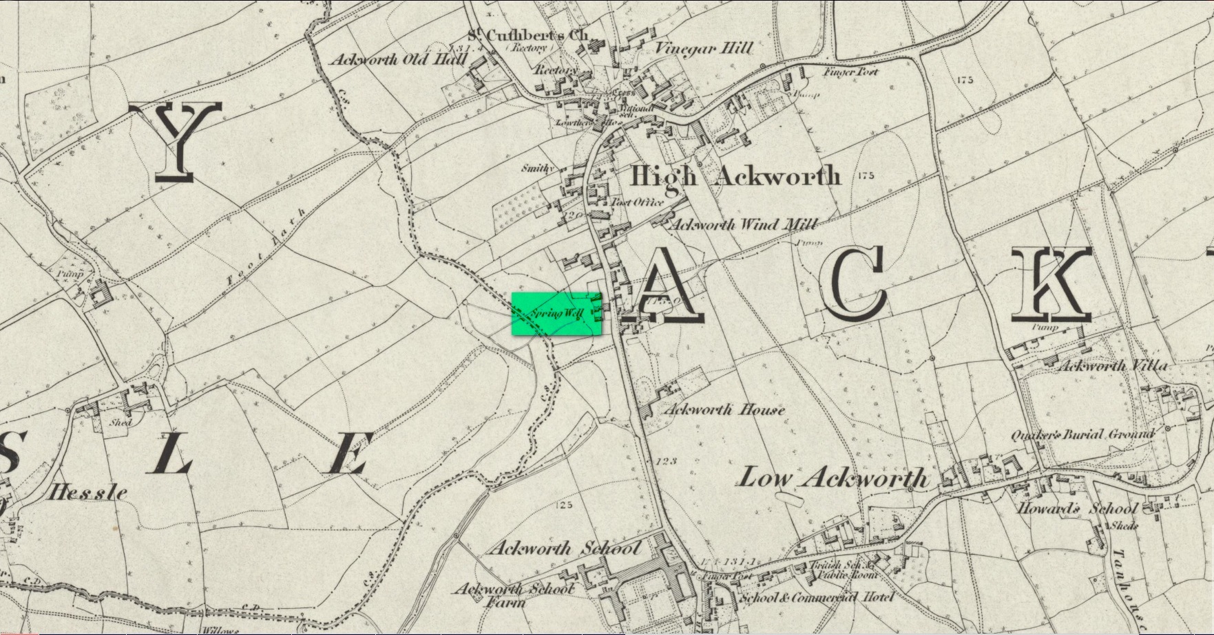
Spring Well – Lady Well?
“This very ancient well is one of the several public wells, which has in recent years somehow become enclosed. From what it derived its name is not known, but from the fact of its being the oldest, it is not unlikely that it was originally set apart by some religious service, and dedicated to ‘Our Lady’ for the use of the inhabitants of the village. In pre-reformation times this custom was common, some wells having miraculous powers ascribed to their waters by the superstitious, like the well of St. Keyne, and in modern times, the ‘Holy Wells’ in Ireland; but nothing of the sort attaches to the well of ‘Our Lady’ at Ackworth.”
To the rear of the old cottages was once a ‘Spring Well’, as shown on the 1852 Ordnance Survey map. It’s possible that this was our Lady Well, dedicated in ancient times to St. Mary. Does anyone know? And is it still there?
References:
Saywell, Joseph L., The Parochial History of Ackworth, James Atkinson: Pontefract 1894.
Acknowledgements:Huge thanks for use of the Ordnance Survey map in this site profile, reproduced with the kind permission of the National Library of Scotland.
Holy Well (destroyed): OS Grid Reference – NN 9397 5770
Archaeology & History
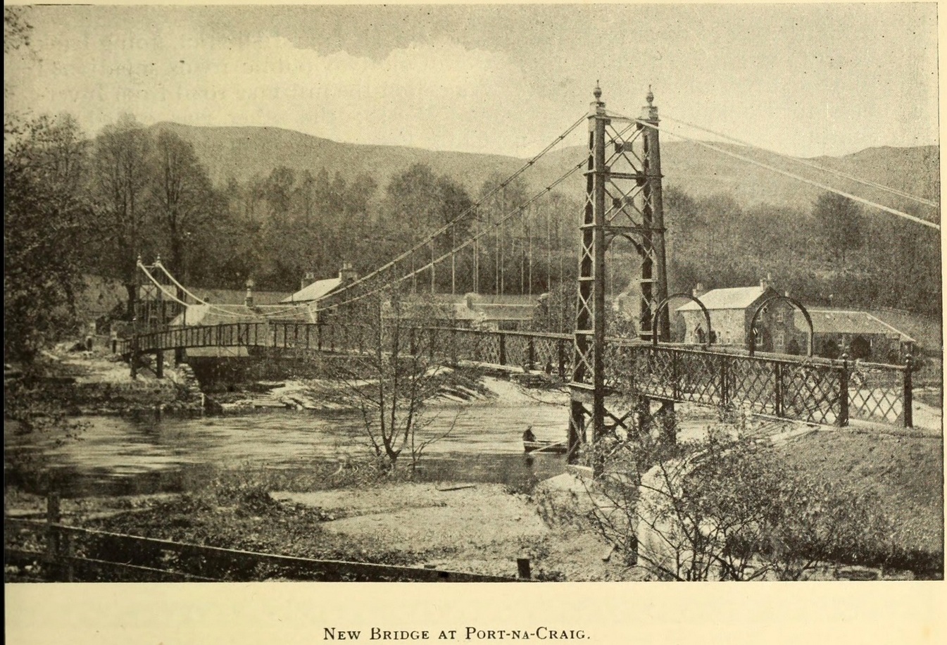
It was more than a hundred years ago that the waters of this sacred well fell back to Earth. They emerged above the eastern side of the River Tummel, close to the bridge where previous there had been a local ferry at the site known as Port-na-Craig. The mythic history of the ferry and the holy well went hand-in-hand, according to local tradition. Its lore was was spelled out by the local author and historian Hugh Mitchell in a speech he gave when a new bridge was opened here in 1913. He said:
The Well was on the far side of the bridge
“The ferry at Port-na-Craig, though not as old as many ferries in Scotland, bears the respectable antiquity of something like eight hundred years. It was established by the monks of Coupar Angus when they got a gift of the lands of Fonab, and as Coupar Angus lay on the north side of the river Tummel, they established the ferry in order to have communication. In those days the ferry boat was made of skins stretched on branches or twigs, so it was somewhat dangerous to cross in, and the monks thought that they would improve the occasion by dedicating the well near the old ferry to St. Bride, so that people, when they ventured across the ferry, might propitiate the saint. It was customary for people to drop either a small coin or a brass pin into the well. He was afraid that brass pins rather prevailed, and no doubt, St. Bride, being a lady, would find them more useful. The well remained until recent times, when it had, unfortunately, to be filled up, on account of being contaminated by neighbouring fields.”
For “fields”, read sewage—for that was the actual reason it was closed. Mr Mitchell (1923) told as much in his subsequent history of Pitlochry, saying that “sewage was percolating into it.” John Dixon (1925) echoed the same thing a few years later.
The curative and magickal properties of St Bride’s Well had considerable renown for local people. Mitchell told that:
“It had a great reputation at one time for cases of lung disease… Pins and coins were dropped into the well as votive offerings, and the bushes above it were hung with rags to call the attention of the saint to the sufferer.”
A few miles north from here, at the back of Blair Castle, an old church is dedicated to St. Bride, whose celebration date is February 1. “The day was known as Candlemas in the Highlands,” wrote Mrs Banks, saying, in commemoration of the Celtic Brigit, “Feill Bride, the festival of Bride, displaced the festival of Mary.”
References:
Dixon, John H., Pitlochry, Past and Present, L. Mackay: Pitlochry 1925.
MacKay, L., Atholl Illustrated, L. MacKay: Pitlochry 1912.
Mitchell, Hugh, Pitlochry District: Its Topography, Archaeology and History, L. Mackay: Pitlochry 1923.
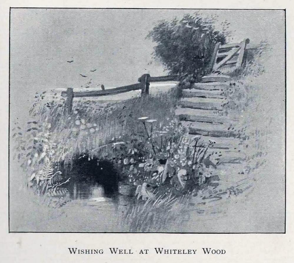
The location of this site has proved troublesome. Even when Rob Wilson (1991) did his local survey of holy wells he was unable to locate it—but it looks as if it shouldn’t be too troublesome to find, as the area in which it flowed is still very much a mix of open countryside and maintained landscapes. Described briefly as the “Wishing Well near Whiteley Wood” in Sidney Addy’s (1893) fine work, he makes a rather hopeful attempt to derive the word ‘wishing’ from German mythology, where “one of the names of the god Wuotan or Odin was Wunsch or Wish.” But – well – you just never know…..
In the landscape at Whiteley Wood there is a Priest’s Hill, so if this Well was found there, it may indeed have had an authentic ‘holy’ designation. But there were a couple of ponds in the area too, which may be fed by this spring. So, first, we need to find the well!
References:
Addy, Sidney Oldall, The Hall of Waltheof, William Townsend: Sheffield 1893.
Wilson, Rob, Holy Wells and Spas of South Yorkshire, Northern Arts: Sheffield 1991.
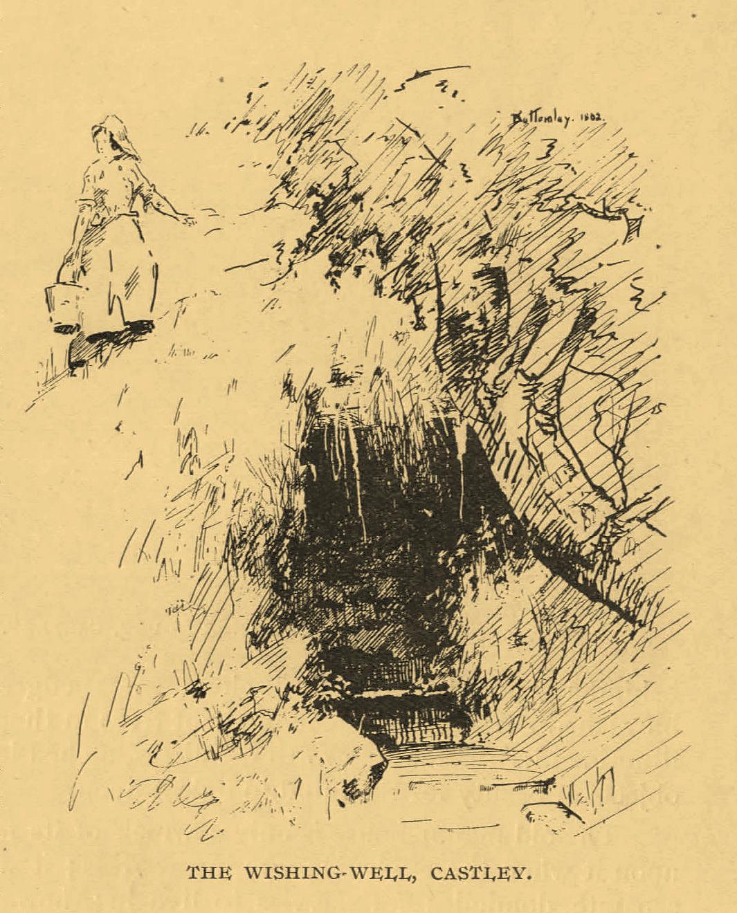
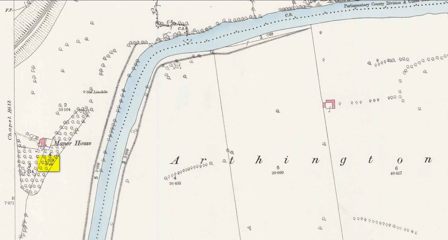
An important water source for local folk in Castley hamlet in previous centuries, this was one of several so-called ‘Wishing Wells’ above the higher banks of the River Wharfe a few miles from each other. It’s a title which, to be honest, was afforded the place when its original local name was removed. It was quite obviously a sacred well in earlier times, as it’s found beneath the slope of Chapel Hill, looking eastwards towards the rising sun, when the waters here (as at countless others) had their greatest remedial or magickal powers. Tradition told there was once a small chapel above the well itself. The spring was highlighted on early Ordnance Survey maps, but all that seems left here today is an occasional boggy mass in the trees at the bottom of the sloping hill.
The old folklorist and antiquarian Edmund Bogg (1904) wrote the following about it:
‘Wishing’ Well on 1888 map
“On the terraced bank near the garden, ’neath an overhanging hawthorn, is a beautiful spring of clear sparkling water, which is locally known as Castley ‘wishing-well.’ More than once we have heard the women-folk declare how, in their maidenhood, they loitered down the bank to the well, usually at eventide, when the birds were warbling their vesper song, and placed their offerings there in silence, yet breathing, as it were, the mute longing of their heart’s desire. It is a natural grotto fit habitation of fairies or the traditional elves. The bank, in which the well is situated, is known as ‘Snake Bank.’”
References:
Edmund Bogg, Higher Wharfeland, James Miles: Leeds 1904.
Acknowledgements:Huge thanks for use of the Ordnance Survey map in this site profile, reproduced with the kind permission of the National Library of Scotland.
On the west-side of the River Spey from Fochabers, follow the road-signs taking you south on the B9015, and near Inchberry is a tiny road on your right (careful not to miss it). Go along here to the end of the long straight road and turn right, down the track. When you reach the trees, bear left along the track to St Mary’s, Orton, marked “Private road”. 🙂 Parking is limited to one car only but very quiet.
Archaeology & History
St Mary’s Well, Inchberry (21st Century Pict)
Set in a stunning location next to the river Spey with a magnificent view of Ben Aigan to the south, St Mary’s Holy Well and Pool is easy to find behind the Chapel / Mausoleum wall, dedicated to the Duff Family. There is a small stone basin in the wall which may have been the Chapel font. At the time of my visit the weather has been dry and sunny for some time. The pool below the iron grate has been recently cleared of leaves before my visit, with no standing water but the stones on the bottom of the pool looked damp. And with the cemetery above and behind the wall, perhaps it was for the better.
It was clear and running, said J.F.S. Gordon (1880) at the end of the 1700s, but when he came to write about it the flow “has ceased for many years, and is now only a feeble, filthy, stagnant Driblet for the use of cattle.” Pilgrimages were made here on the first Sunday in May, and water collected from the site was kept for a year, in return for an offering (usually a stone or other inanimate object) that enabled the magickal spirit of the well to enact cures.
Folklore
A site described by Watson (1868) as being “long held in superstitious reverence”, the well was said to cure whooping cough, eye problems and joint conditions. It had thoroughly un-christian shennanigans practised here by local folk, much to the consternation of the usual culprits! Visited extensively by people from far and wide, Mr & Mrs Morris (1981) told,
(21st Century Pict)
“The visits displeased the Kirk and there were various summonses to the Session for “going supersticiously to a Vell at Speyside” and of persons who “kneillit about the chappell and drank the water.” The minister at Ruthven reported that a large number had gone to the chapel well “thrie Saturdays before Lambas and thrie efter called the six silie Saturdayes, and that the conventions wer on the night or before day in the morning.” And “quhairas zierlie about Lambnes, the ignorantes repaired to ane wel at this kirk, called Our Ladie Wel, superstitiouslie, and kneeled about the said kirk, it is reportit that the evil is removed.” This may be the well associated with the White Witch, Dame Aliset, who cured a fairy child with simples and the well water.”
References:
Bord, Janet, Holy Wells in Britain – A Guide, HOAP: Wymeswold 2008.
Watson, J.& W., Morayshire Described, Russell & Watson: Elgin 1868.
Acknowledgements:Huge thanks for use of the Ordnance Survey map in this site profile, reproduced with the kind permission of the National Library of Scotland.
Healing Well (destroyed): OS Grid-Reference – NT 2547 7337
Archaeology & History
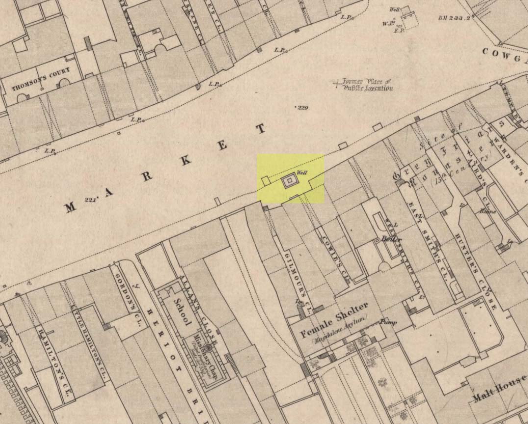
Muses ‘Well’ on 1852 map
We have the historical detective work of Stuart Harris (1996) to thank for the location and probable meaning behind the name of this long-lost well, that could once be seen along Haymarket, near the heart of the old city. Shown on the 1852 OS map, without name, the site was recorded as a public well “from 1502 onwards,” he wrote — and its name was variably written as muse, muss, meus and mwse, which led him to surmise that it was from the old Scots word “meuse”, or the “well by the stables”; although I cannot find this validated in the established dialect dictionaries and glossaries of William Grant (1934-76) or Simon Taylor (2012). Their relative definitions tell it to be of a mouse, or a small trackway left by rabbits, hares or rodents, running between hedgeways. This would mean the ‘Muse Well’ was a variant around a “well by an animal track”, which in earlier centuries were very important to note, as wild animals were indicators of food (amongst other things).
This aside, “the King’s Stables, dating from the 1340s, were of course over 200 yards further west,” he wrote,
“but the convent of the Greyfriars, founded in 1471 in the Cowgatehead only about fifty yards east of the Muse Well, certainly gave lodging to travellers of the more distinguished sort, and although no early record of stables here has come to light, it may be no accident that the only stables recorded in the Valuation Roll of 1635 as being on the south side of Grassmarket were in McIntyre’s Close, which had its entry ten yards east of the Well.”
References:
Grant, William (ed.), The Scottish National Dictionary – 10 volumes, SNDA: Edinburgh 1934-76.
Harris, Stuart, The Place-Names of Edinburgh: Their Origins and History, Gordon Wright: Edinburgh 1996.
Taylor, Simon & Gilbert, Markus, “Elements Glossary”, in The Place-Names of Fife – volume 5, Shaun Tyas: Donington 2012.
Located in the copse known as Godwell’s Grove on the western boundary of Arkesden, there are good grounds for thinking this was a sacred well: not necessarily relating to the christian God, but what A.H. Smith (1956) described simply as, from the old English, “a (heathen) god.” Another site of the same name is found in Wiltshire. In the local survey by Parish (2010), he told that “its name suggests it is a holy well.”
In Reaney’s (1976) survey on English place-names, he looks at a number of places where the element “god” is found and explores the notion of them recording a personal name, Gode. This is evident of course, but he stated that,
“it would indeed be a remarkable coincidence if all these names…were to contain the personal-name Gode, a short form of Godric, Godwine, etc. It in inconceivable that the reference should be to the christian deity… All are situated in areas of early settlement where heathen place-names might be expected and may well contain OE god, ‘a god’.”
There is no longer any trace of the well.
References:
Parish, R.B., Holy Wells and Healing Springs of Essex, Pixyled Press: Nottingham 2010.
Reaney, P.H., The Place-Names of Essex, Cambridge University Press 1935.
Reaney, P.H., The Origin of English Place-Names, RKP: London 1976.
Smith, A.H., English Place-Name Elements – volume 1, Cambridge University Press 1956.
Robin Hood wells are numerous in Yorkshire and Derbyshire, but finding them in this neck o’ the woods is unusual (a Robin Hood’s Farm can be found nearly 14 miles south). The waters here would have had obvious importance for local peasant folk in bygone centuries, perhaps with scatterings of Beltane and Midsummer rites hereby; but it seems that records are silent on such matters. The only reference I can find of this place is in Bracken’s (1860) fascinating work on Sutton Coldfield, where he told that,
“At the extremity of the parish, near Pype, a little field is still called the Bowbearer’s Croft. Tradition says two officers of the chase, bowbearers, had a lodge there; and that their duty was to guide the travellers across the wild country. A very old cottage, that had been well built, was removed from the croft in 1828. In that neighbourhood was a fountain, called Robin Hood’s well, now enclosed within the grounds of Penns, where the natural beauties of the situation have been judiciously displayed and improved by the taste of the late proprietor, Joseph Webster.”
Marshy ground to the east of Pype Hall fed the large pond, which is one contender for the site of this lost well. What has become of it? A search in the local library archives for any old manorial maps, or the field-name maps showing Bowbearer’s would prove truly helpful in relocating this site.
References:
Bracken, L., History of the Forest and Chase of Sutton Coldfield, Simpkin Marshall: London 1860.
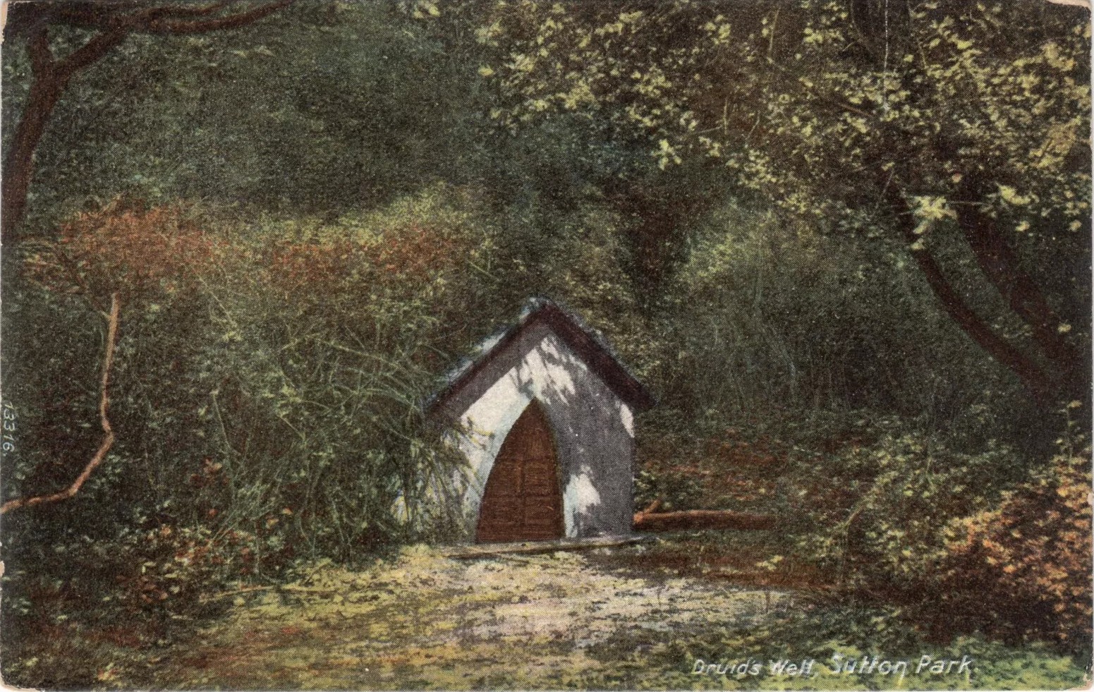
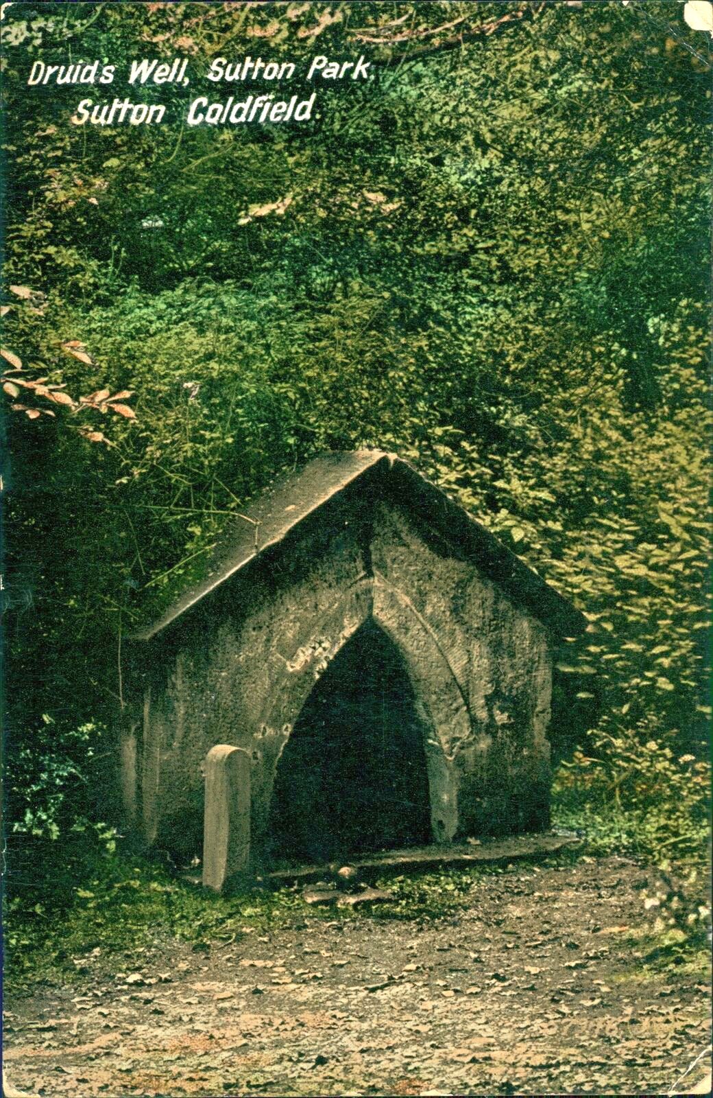
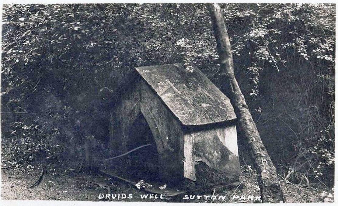
Highlighted on the 1884 Ordnance Survey map of the region and located beyond the far eastern end of Braceridge Lake, this legendary well has seen better days. A small well-house once covered the spring, but all we have left today is little more than a rectangular stone-lined concrete hole-in-the-ground where the waters collect (hopefully some local folk can bring it back to life). But in the 19th century it was well known, much frequented and maintained.
Not much seems to be known about its mythic history, as the traditions surrounding its dual pagan-christian dedication seem to have been forgotten. When the local writer Tom Burgess (1893) came to explore its history, he merely wrote:
“How it came to be called the Druids’ Well is not known, it is scarcely necessary to say that it can have no Druidical connection; it is very probable, however, that it was dedicated to Saint Mary long before the dam of Bracebridge Pool was made by Ralph Bracebridge in the reign of Henry V.”
Druids Well in 1917Druid’s Well in 1932
Jeremy Harte (2008) suggested that this well’s druidic association may have come from a local man, William Hutton who, in the middle of the 18th century, “speculated on a druid sanctuary near Sutton Coldfield.” But before Hutton, the 17th century Staffordshire topographer, Robert Plot, suggested that an arch-druid held residence on Barr Beacon, which is less than three miles west of here. This idea was echoed by Midgley (1904) who told that Barr Beacon “is supposed to have been a Druidical shrine.” Just over three miles to the northwest, the Druid’s Heath (a place-name derived, apparently, from an old family) at Aldridge also had its own array of folklore which, perhaps, may have had something to do with this well’s association. When Roy Palmer (1976) wrote about the Druid’s Well in his folklore survey, he told that Sutton Coldfield,
“is said once to have been the seat of the arch-druid of Britain; perhaps this was his well, which was later christianized.”
So much to choose from…
References:
Bord, Janet, Holy Wells in Britain – A Guide, HOAP: Wymeswold 2008.
Bracken, L., History of the Forest and Chase of Sutton Coldfield, Simpkin Marshall: London 1860.
Harte, Jeremy, English Holy Wells – volume 2, Heart of Albion press: Wymeswold 2008.
Midgley, W., A Short History of the Town and Chase of Suton Coldfield, Midland Counties Herald: Birmingham 1904.
Palmer, Roy, The Folklore of Warwickshire, Batsford: London 1976.
Acknowledgements:Huge thanks for use of the Ordnance Survey map in this site profile, reproduced with the kind permission of the National Library of Scotland.
Holy Well (destroyed): OS Grid Reference – SP 8234 9542
Also Known as:
Our Lady’s Well
Archaeology & History
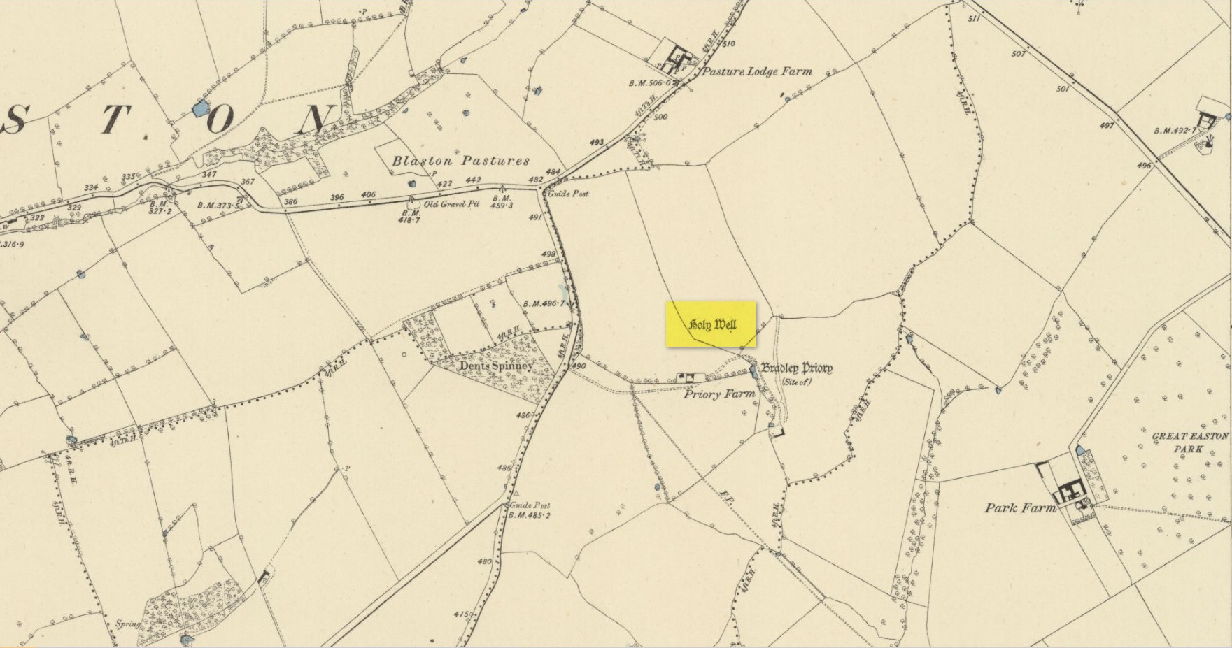
Site shown on 1885 map
There seems to be very little known about this site. It was located in fields just above the site of the Augustinian Priory of St Mary, founded in 1220 CE, where now is Priory Farm, but there seems to be no trace left of it. The great Leicestershire antiquarian John Nichols said the well had been dedicated to Our Lady, the Virgin Mary. This was echoed in John Curtis’ (1831) survey, who told that, “where the Priory formerly stood, a Dwelling House has been erected; and near it is a Well called Our Lady’s Well.” He told that it was deep and “walled below the surface.”
References:
Curtis, John, A Topographical History of the County of Leicester, W. Hextall: Ashby-de-la-Zouch 1831.
Rattue, James, ‘An Inventory of Ancient, Holy and Healing Wells in Leicestershire’, in Transactions Leicestershire Archaeological & Historical Society, volume 67, 1993.
Trubshaw, Bob, Leicestershire and Rutland’s Holy Wells, Heart of Albion: Nottingham 2024.
Acknowledgements:Huge thanks for use of the Ordnance Survey map in this site profile, reproduced with the kind permission of the National Library of Scotland.