Holy Well (lost): OS Grid reference – SW 4025 3062
Archaeology & History
Just over a mile northwest of the superb Sancreed Well, we find documentary evidence from 1778 recording the field-name of Chapel Well Close here, although there seems to be no remaining spring or well and nothing is shown on the early OS-maps. Official records define it as a “medieval well” and speculate that it may have been associated with the nearby Boscence Chapel and possibly dedicated to St. Winwaloe.
References:
Anon., The Church and Parish of Sancreed in the County of Cornwall, Brewer: Sancreed c.1960.
Healing Well (destroyed): OS Grid reference – TQ 330 827
Also Known as:
Balsamick Well
Archaeology & History
In that typically rambling style beloved of early writers on medicinal springs, Timothy Byfield (1687) narrated the tale of uncovering this well in an almost alchemical discourse. It was located when digging out the cellar of a house near Charles Square in the 1680s. Upon investigation, the waters were found to possess a good quantity of sulphur and a small amount of iron, leading Byfield to proclaim it could cure a whole army of medical disorders, from cleaning out blockages in the alimentary canal, to treating kidney stones, scurvy, ulcers, headaches, migraines and more. If used correctly and in the right amount,
” There is,” he says, “no unwholesome glebe (concretion) or any dangerous mineral or metal (in them) that casts one unhappy ray into this healing fountain.” On the contrary, they set up ‘* such a pretty bustle or ferment in nature that makes gay a well-temper’d Healthy Body.”
In the early days when Spa Wells were in vogue, the Balsamic Well became a competitor to the nearby St Agnes le Clear Well, which is probably the reason why one doctor dissuaded the toffs of the time to avoid it!
The waters possessed a slight vinegar-esque flavour—hence the name. In John MacPherson’s (1871) work, he described it as a “chalybeate well” and despite it having that typical “bituminous scum on it, strange to say,” it yielded “a pleasant aromatic flavour.” The site has long since been covered over.
References:
Byfield, Timothy, A Short and Plain Account of the late-found Balsamick Wells at Hoxdon, London 1687.
Foord, Alfred Stanley, Springs, Streams and Spas of London: History and Association, T. Fisher Unwin: London 1910.
Hembry, Phyllis, The English Spa 1560-1815, Athlone Press: London 1990.
MacPherson, John, Our Baths and Wells, MacMillan: London 1871.
Sunderland, Septimus, Old London Spas, Baths and Wells, John Bale: London 1915.
Holy Well (destroyed?): OS Grid Reference – SP 5549 4574
Also Known as:
Stock Well
Archaeology & History
This seemingly lost holy well was first mentioned by John Morton (1712), who told us that it was the source of the River Tove. About eighty years later, John Bridges (1791) wrote that,
“In this town was formerly a grange to the monastery of St Andrews in Northampton; and a spring which riseth near the place where this house stood, still retains the name of Halywell Spring.”
Little else was written of the site until H.C. Smith’s (1933) in-depth overview of the famous Washington family (some dood called George apparently) of Sulgrave, where he echoed John Morton’s words that the River Tove “rises from the spring of Holy Well, near the site of the old Grange of St. Andrew’s Priory.” He told that it was located up Stockwell Lane where an old water-mill was located and “the water for the mill is provided by a large mill-pool fed by a spring known in former times as Holy Well Spring.” Local historian Beeby Thompson (1914) identified the Stock Well as being the later alternative name for our holy one.
References:
Bridges, John, The History and Antiquities of Northamptonshire, D. Price: Oxford 1791.
There’s a minor discrepancy of opinion as to the exact location of this site, so I’ve chosen to go right in-between the positions cited by Leggat (1987): SW 836 433, and Meyrick (1982): SW 838 434.
The site was mentioned by Charles Henderson, who told that around the year 1750 there was a medicinal well at Sunny Corner, known as “Glastonbury Well”. Its waters had the ability to “cure all disorders,” but its reputation was apparently short-lived, which would suggest that its fame beyond local villagers was concurrent to the rise of Spa Wells amongst the upper- classes at that time.
In the Leggats’ (1987) survey, no locals they spoke with had ever heard of the place; but that they “found a spring halfway up the lane adjacent to Sunnyside House which had been used in the past from time immemorial as a domestic water supply to a scattering of local cottages” and wondered if this might have been the long long Glastonbury Well…
References:
Adams, J.H., “The Mediaeval Chapels of Cornwall,” in Journal Royal Institution of Cornwall, volume 3 (new series), 1957.
Henderson, Charles, One Hundred and Nine Parishes of the Four Western Hundreds of Cornwall, Oscar Black: Truro 1955.
Leggat, P.O. & D.V., The Healing Wells: Cornish Cults and Customs, Dyllansow Truran: Redruth 1987.
Meyrick, J., A Pilgrims Guide to the Holy Wells of Cornwall, Falmouth 1982.
Holy Well (destroyed?): OS Grid Reference – SO 9609 8284
Archaeology & History
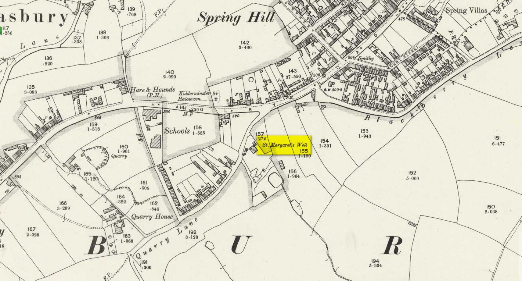
The site on the 1904 map
Shown on the 1904 OS-map, beneath the aptly-named St Margaret’s Hill on its northern side, we can see where the holy well of St Margaret used to be, not too long ago. Although it seems to have fallen pray to industrial destruction, there are a number of old references to the site, mainly gathered together in Jeremy Harte’s (2008) magnum opus on the subject. It was also mentioned in a survey by the British Geological Society (Richardson 1930) where we were told that it was,
“in the private grounds of a house recently erected, and is a spring issuing from the Halesowen Sandstone at the junction of two faults (shown west of the ‘H’ of Hasbury on the new series Geological Map, Sheet 168) about 100 yds SW of the point where Blackberry Lane joins Hagley Road. It is referred to, as a well of good cold unmineralised water, by T. Nash in 1781.”
And it was Mr Nash who gave us the earliest description of the place, saying:
“In the hamlet or township of Hasbury is an ancient holy well, called St Margaret’s Well, which formerly had much good stonework about it; but that was wholly removed in the year 1747. One of these stones contained some curious sculpture, the figure of a man in a posture of hasty walking, and in the next compartment that of another man leaning on crutches… This place is called Margaret’s Hill and the water of the well supplies a small brook, which runs below the Grange, and falls into a piece of water at the end of the town, called Cornbow Pool.”
It’s more than probable that the old carvings he described—of one man on crutches and the other of a figure walking speedily—represents one of the main curative allegations that these waters possessed. Cases of people walking on crutches to sacred wells, drinking the waters, then walking away without them (and in many cases leaving their crutches at the well-side as testament to its properties) are commonplace. And, aptly enough, the curative elements of this ancient site has been maintained in modern times with the medical centre of St Margaret’s Well Surgery being built by this very spot!
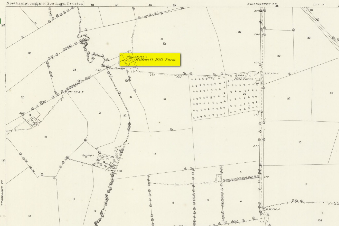
A mile south of Kislingbury village, just by the roadside is the old Hill Farm. In times gone by—as the early OS-maps show—a trackway led from here, westwards, for just a few hundred yards, until it reached the old farm of Hollowell Hill, all trace of which has long since gone. The farm owed its name to the existence of a holy well mentioned briefly in 14th century records in the Cartulary of St. Andrews, Northampton, where it was described as Halywellhille, or the Holy Well on a hill. All trace of it seems to have been lost. A ‘Spring’ that is shown on the 1885 map, a few hundred yards south of the old farm, seems to be the closest contender, but it seems more likely that the well was adjacent to, or beneath the farm-building.
References:
Gover, J.E.B., Mawer, A. & Stenton, F.M., The Place-Names of Northamptonshire, Cambridge University Press 1975.
This long-lost stone cross should not be confused with the more recent one, erected by one Mr H. C. Richards in 1901 to commemorate some malarky about Edward VII. The one in this profile was much older than that, although both of them were erected close to each other. The older cross was found, said T.H. Cole (1884), “at the head of the Town, near All Saints’ Church.” Also known as the North End’s Cross, the old market was held here and close by were the gallows, the whipping post and the stocks.
In John Bridges’ (1791) account of the parish of Aynho, he made mention of an old market cross that stood in the village, but even in his day it had been removed and so we know little about it. Chris Markham (1901) included it in his inventory of crosses, but could find no additional details to those provided by Mr Bridges. He told us:
“In the seventeenth year of Edward II (1323-4) John de Clavering was lord of the manor of Eynho, and obtained the King’s charter for a weekly mercate, or market, to be held every Tuesday, and a yearly fair on the vigil and day of St. Michael and two days following. This market was continued until the twentieth year of James I (1622-3), when Richard Cartwright obtained a new charter for holding the market and fair, with the addition of another yearly fair on the Monday and Tuesday after Pentecost. Bridges, however, writing about 1700, says that the market had been discontinued for some sixty years, and that the market cross had been then long since taken down. Since then the fairs have also sunk into desuetude.”
References:
Bridges, John, The History and Antiquities of Northamptonshire – volume 1, T. Payne: Oxford 1791.
Charles Pooley (1868) gave a somewhat vague description of this site, telling that, “there is authority for believing that at one time a Cross was set up in the village.” I can find no other reference to this monument which, I presume, has been destroyed. (the grid reference cited is an approximation near the centre of the village, where village crosses were usually located)
References:
Pooley, Charles, Notes on the Old Crosses of Gloucestershire, Longmans Green: London 1868.
In R.C. Skyring Walker’s (1928) fine survey of Gloucestershire’s holy wells, he lamented the passing of this site, telling how
“it is sad to relate that this well has totally disappeared and its precise site is unknown.”
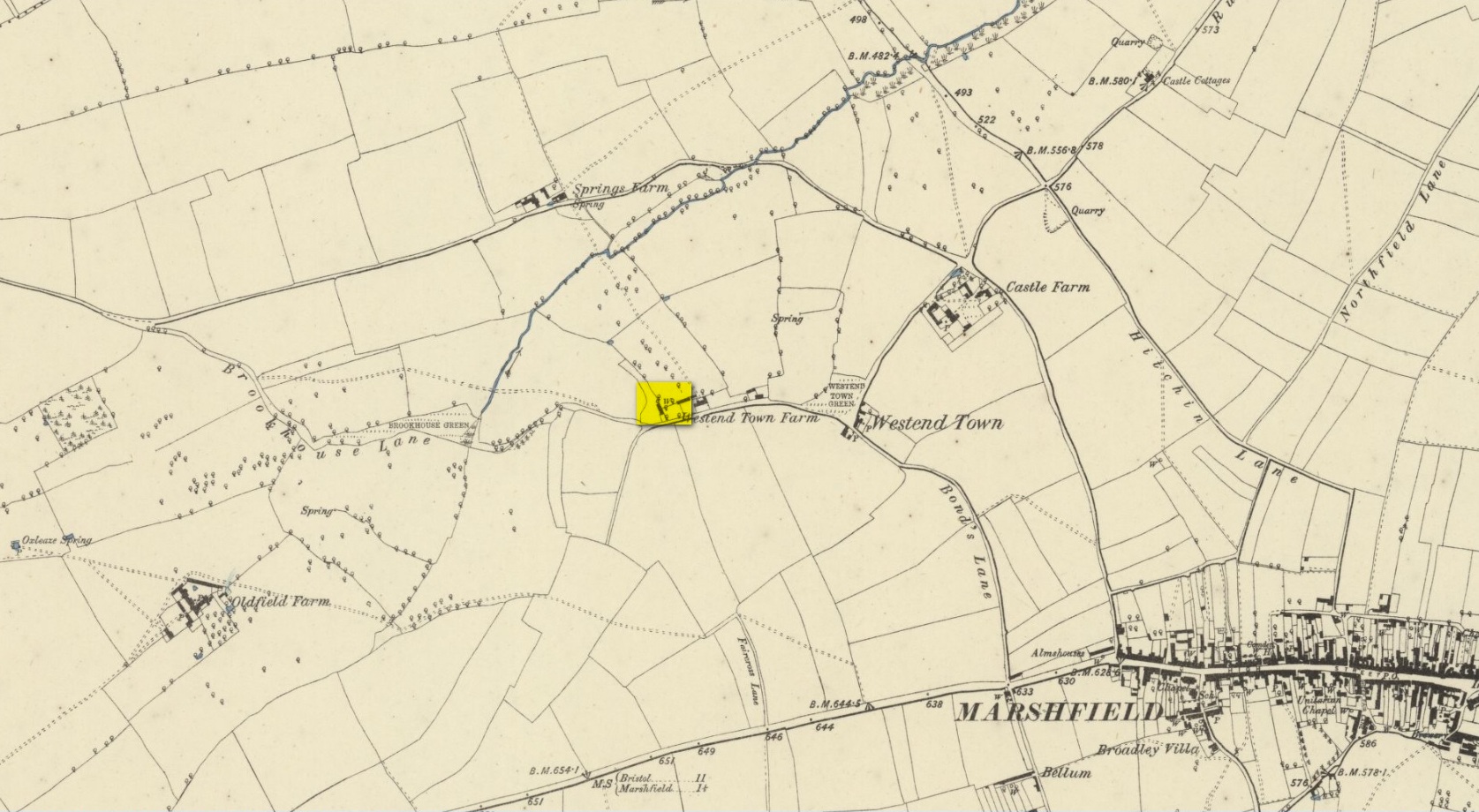
Since those words, the situation regarding its whereabouts has not been resolved. First mentioned in Samuel Rudder’s (1779) work, the main clue we’ve got regarding its whereabouts is his description of the adjoining hamlets and village tithes:
“Westonton, formerly called Old Marshfield, or Little Marshfield. It has been a distinct parish, called St Pancras, according to Sir Robert Atkins, and a well in this hamlet still bears the name of that saint.”
‘Well’ on 1886 OS-map
Westonton is the old farmhouse of Westend Town less than a mile northwest of Marshfield where, on early Ordnance Survey maps, a Well is shown. To the north of this is Springs Farm. This latter name probably has no bearing on St Pancras’ Well; but the location cited by Rudder of the well being in Westend Town gives us a damn good indicator as to where local historians should dig for this forgotten sacred site.
The Well was described in T.D. Fosbroke’s (1807) work, but only in passing. St Pancras’s festival date is April 3. (the grid reference cited for this well is an approximation)
References:
Fosbroke, Thomas D., Abstracts of Records and Manuscripts Respecting the County of Gloucester – volume 2, J. Harris: Cirencester 1807.
Rudder, Samuel, A New History of Gloucestershire, S. Rudder: Cirencester 1779.
Smith, A.H., The Place-Names of Gloucestershire – volume 3, Cambridge University Press 1964.
Walters, R.C. S., The Ancient Wells, Springs and Holy Wells of Gloucestershire, St Stephens Press: Bristol 1928.