Follow the same directions as if you’re gonna visit the Idol Stone carving. From here, keep walking uphill until your reach the rocky crags on the slope above. Go left (southeast) along the small footpath that runs along the top of this ridge for 350 yards (320m) and, where the path begins to very gradually slope back downhill a little, go sharp left, downhill for 50 yards, where a couple of large rocks stand out. Before one of these, low down in the heather, you’ll find this curious cup-and-ring stone.
Archaeology & History
This is a lovely cup-and-ring stone, seemingly recorded for the first time by fellow rock-art student Stuart Feather (Radford 1968) in one of his numerous ramblings over these moors. It’s a difficult habit to break once the bug bites! The rock itself is unusual, possessed of undulating geophysical waves or ripples across its surface, similar to a cluster of others a couple of miles west near the very top of Rombald’s Moor. The curvaceous feature alone would have given this stone a spirit-nature of its own, different from the others in this area — though we may never know what that might have been.
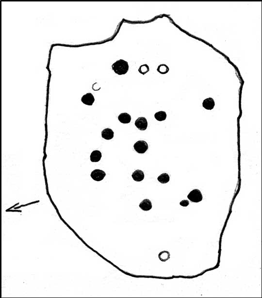
Primary design (after Hedges)
The cups carved onto this rock are cut much deeper than most other prehistoric carvings along this ridge and, for some reason or other, give an immediate impression of having been painted and coloured in lichens or other natural dyes, to encourage or awaken the mythic history within and around the stone. It’s a formula that occurs worldwide and needs serious consideration, not just here, but at many other outcrop carvings in Wharfedale and much further afield.
The carving was described in John Hedges’ (1986) fine survey as a,
“Fairly small flat rock, level with the ground, sloping slightly in heather and crowberry, its surface layered in waves which appear to have been incorporated in the design which covers the rock. About 25 cups, some very deep and some showing pick marks, three are enclosed in rings, one of which has three cups in its circumference and a groove leading from it to edge of rock.”
Many other carvings scatter the moorland plain of Woofa Bank — some recorded, others not — in a region rich in Bronze Age and probably earlier cairns. We’ll add all their profiles here as time floats by…
References:
Bennett, Paul, Of Cups and Rings and Things, unpublished: Shipley 1981.
Boughey, Keith & Vickerman, E.A., Prehistoric Rock Art of the West Riding, WYAS: Wakefield 2003.
Hedges, John (ed.), The Carved Rocks on Rombalds Moor, WYMCC: Wakefield 1986.
Radley, J. (ed.), “Yorkshire Archaeological Register, 1968,” in Yorkshire Archaeological Journal, volume 42: part 166, 1968.
Cup-Marked Stone: OS Grid Reference – SE 1380 4521
Archaeology & History
Buried Stone carving
One of this regions many simple cup-marked stones, this example is another that is not in the archaeological records as it was rediscovered on March 1, 2012, by one-time rock art student, Michala Potts of Keighley. Found in association with one of the many prehistoric cairns in the landscape, it is a small flat rock, that was mainly covered over in dead bracken remains. There are two very distinct archetypal cup-marks etched on the westernmost half of the stone, with a possible faint third in-between the two. The larger of the two cups measures 2 inches across and is a half-inch deep; the other cup being 1½ inch across and roughly the same depth. Several other cup-and-ring stones can be found close by.
Buried Stone, when dry
The curious-looking inverted ‘F’ beneath the two cups is somewhat of a dilemma, as part of it appears to have been carved and has the hallmark of a typical boundary marker. However, the top line is almost certainly a natural feature on the rock, but the vertical and second horizontal line may have been cut into the rock at a later date. There are remains of some medieval workings just 10 yards away from this stone, which may account for the enhanced lines; but we could do with a decent geologist to have a look and tell us one way or the other!
Cup-Marked Stone: OS Grid Reference – SE 1395 4517
Getting Here
Sketch of the main design
Once you’re on Ilkley moorland itself, head over to the Little Skirtful of Stones giant cairn. From here, walk due east for 115 yards where you’ll come across an overgrown dried-up (usually) dyke cut into the heath, which runs roughly north-south. Walk over the dyke onto its eastern side and just a few yards in front of you, in a slight dip, you’ll found a female oval-shaped boulder amidst the heather.
Archaeology & History
Rediscovered on Tuesday March 6, 2012, this medium-sized rounded (female) rock has somehow evaded all previous archaeological evaluations. It is one of at least five previously unrecorded cup-marked stones found close to each other on the eastern section of Rombald’s Moor near the Little Skirtful of Stones. The rock measures roughly 2 yards by 1½ yards and possesses at least 15 cup-marks that cover most of its surface. Each cup-mark averages about 2 inches across and are less than ½-inch deep. There is a natural ‘bowl’ in the southern section of the rock with a typical cup-mark in it and a smaller one in close association.
Dyke Stone cupmarksand from another angle
The other cup-markings found close by, appear to be associated with the prehistoric cairns but this stone — the largest of the group — lacks any immediate relationship with such monuments. Further ground explorations are required at other potential spots close by; plus we could do with getting back here when the sunlight’s better, so we can get some clearer photos!
From the Idol Stone carving, keep walking along the footpath that takes you up the hill and further onto the moor. Keep walking for another few hundred yards until you reach the old pits at Lanshaw Delves. Walk due east through the heather for 250 yards or so, until you hit the flat-topped cup-and-ring marked Lanshaw Stone. Walk 50 yards NNE from here, and keep diligent. You’ll find it!
Archaeology & History
…and from another angle
This is another carving which is troublesome to locate when the heather’s fully grown. Like other cup-and-rings scattered along this geological ridge, it is associated with additional prehistoric features which local archaeologists have never bothered plotting: a real peculiarity, as this is a truly rich archaeological arena. Low walling and cairns are close by, all from the Bronze Age and possibly earlier. When we were children exploring this section of the moor, we also found a few flints scattered about (we threw ’em back into the peat, where they probably still remain). The carving itself may be neolithic, but in all honesty until we get a decent archaeologist in the area willing to truly focus on our ancient monuments, we’ll never know the time periods of the remains here with any certainty.
When Boughey & Vickerman (2003) recorded this and other carvings nearby, they described it simplistically as:
“Medium-sized, rounded, triangular rock of medium grit, up to height of heather at centre. Two cups, of different size, and perhaps another.”
I’m not too sure about another to be honest, but I’d love to be wrong! A curious straight line may run parallel to the cups, but this too may be natural. I reckon the carving’s only gonna be of interest to the real rock-art fanatics out there. But nearby, as you’ll find, are more impressive archetypal cup-and-rings…to be described later…
References:
Boughey, Keith & Vickerman, E.A., Prehistoric Rock Art of the West Riding, WYAS: Leeds 2003.
A bit hard to locate. Take the route past the Haystack Rock onto the Idol Stone and Idol Rock, uphill, for a few hundred yards till you meet the distinct vegetational change and pits of Lanshaw Delves that run east-west. At this point on top of the path, walk to your left, due east, for 270 yards (247m), staying along the top of the ridge, then when you reach the flat-topped cup-and-ring marked Lanshaw Stone, head due north going down the heathery slope for about 50 yards until you find this reasonably large though flat earthfast stone. If you wanna locate it, you’ll find it!
Archaeology & History
Close-up of cupmarks
On an excursion that was exploring the relationship between prehistoric tombs and rock art in the area, this shallow carving was found that had, in a confusing way, been mis-catalogued in the archaeology registers – which confused us poor simpletons at the time! Initial investigation indicated one primary cup-marking near the east-side of the stone, but when highlighted there was the possibility of another faint cup on the same section of the rock, just above the obvious one – but this still isn’t clear.
Cup-marks in better light
Found in association with other prehistoric remains close by, the carving is one that will probably be of interest just to those hardcore rock-art freaks amongst you. However, there are a dozen other carvings close by, several of which are impressive cup-and-ring designs. It’s one of around 50 cup-and-ring carvings on Rombald’s Moor that’s not in the Boughey & Vickerman (2003) survey — and this isn’t an easy one to see unless the lighting conditions are right. This low rounded (female) rock has, since its initial discovery by the hardworking Mrs Potts, been stripped of its vegetation by members of the Ilkley CSI team when they found it for themselves. Worth looking at if you’re exploring the other carvings nearby.
Get to the Cow & Calf Rocks, go up across the car-park as if you’re gonna go up onto the moor and walk up the steep footpath uphill to the left of the crags. Once you get level with the crags, take the footpath bending left and walk along here for 110 yards, keeping your eyes peeled for the low smooth rock on the right of the footpath, just where another path meets it. You’ll find it.
Archaeology & History
Close-up, from above
This quiet little stone has seen better days. Nearly destroyed a few weeks ago when the Emmerdale Farm film-crew churned up sections of the moor right over the side of this carving—but thankfully it still remains intact (you or I would have been prosecuted for such damage).* The carving is a simple one in graphic terms, comprising simply of three cup-markings, all on the southern side of the rock. Close to several other petroglyphs (the Wray Stone is 78 yards north and several other more ornate carvings are close by), the carving was first described in the Hedges (1986) survey as a “small, low smooth grit rock sloping slightly NW to SE in crowberry, bilberry, grass and bracken. Three clear cups.” But it has to be said, one of them is fading fast. Let’s hope this humble little carving doesn’t fall prey to those who are gradually turning our moorlands into a park.
References:
Boughey, Keith & Vickerman, E.A., Prehistoric Rock Art of the West Riding, WYAS: Leeds 2003.
Hedges, John, The Carved Rocks on Rombald’s Moor, WYMCC: Wakefield 1986.
* As the footpaths on Ilkley Moor continue to be widened and paved by those who reckon they like these moors, it’s obvious that more prehistoric sites up here are going to get damaged. It’s difficult to see what the local archaeologist or Natural England are doing to ensure that these environmentally-damaging schemes don’t encroach on the mass of rich prehistoric sites on the moors, most of which have never been adequately assessed (the philosophy of “if we don’t know it’s there, it doesn’t matter if we destroy it” seems evident in some of those working for the local council). Before any work or structures are dug on Ilkley Moor, an archaeological assessment is, I believe, supposed to take place – but I think this ‘work’ consists merely of looking at their own limited records, without any detailed fieldwork being undertaken. As we know from research undertaken by rock art students at TNA, CSI and elsewhere, there are still many cup-and-ring stones, cairns and archaeological features constantly being discovered on these moors that are not in the record books.
From Ilkley, take the Wells Road heading towards White Wells, bending round the bottom of the moor, making sure you keep left along Westwood Drive (not further up the moor along the Keighley Road). Keep along Westwood Drive – it becomes Panorama Drive after a while – until you come to the small copse of woods on your right, a short distance before the end of the road. Go along the footpath by the wall at the side of the house, bending into the woods after 10 yards. Another 10 yards on, you’re near the edge a drop down the slope, where a number of large rocks are seen. Look around!
Archaeology & History
Carving 236 (after Boughey & Vickerman)
A singular cup-and-ring carving can be seen, rather faintly, near the nose-end of this large mossy stone, close to the edge of the ridge. It is one of a small cluster of carvings that remain in this small bit of woodland. Other highly ornate carvings could once be seen in the same stretch of woodland — where the rich houses now stand — amidst remains of a prehistoric enclosure or settlement of some sort. All remains of this settlement have been destroyed, which is a pity as it may have given us helpful information about the nature of this carving and its nearby relatives.
References:
Bennett, Paul, The Panorama Stones, Ilkley, TNA: Yorkshire 2012.
Boughey, Keith & Vickerman, E.A., Prehistoric Rock Art of the West Riding, WYAS: Wakefield 2003.
Hedges, John (ed.), The Carved Rocks on Rombalds Moor, WYMCC: Wakefield 1986.
Take the A6034 road between Addingham and Silsden and, at the very top of the hill between the two towns, at Cringles, take the small road of Cringles Lane north towards Draughton. Less than a mile on, veer to left and go along Bank Lane until you reach the track and footpath on your right that takes you to Moorock Hall. On the other side of the Hall, take the track on your left, along the wallside; and where the track turns left again, look into the field on the other side of the wall. You can see some of the ditch and embankment running across the field.
Archaeology & History
Found within the southwestern segment of the gigantic Counter Hill enclosure, near Woofa Bank, Eric Cowling (1946) described “an almost obliterated fortification” which has certainly seen better days — though you can make out the ditched earthwork pretty easily at ground level. When T.D. Whitaker visited this place sometime before 1812, he described it as a camp that “was found to contain numbers of rude (?!?) fireplaces constructed of stone and filled with ashes.” He also thought the enclosure was Roman in nature.
Western line of embankment
It’s a large site. Running around the outer edge of the embankment, this enclosure measures roughly 378 yards (345m) in circumference. It has diameters measuring, roughly east-west, 132 yards (121m); and north-south is 95 yards (87m). The ditch that defines the edges of the enclosure averages 6-7 yards across and is give or take a yard deep throughout — but this is not an accurate reflection of the real depth, as centuries of earth have collected and filled the ditch. An excavation is necessary to reveal the true depth of this. There also seems to have been additional features constructed inside the enclosure, but without an excavation we’ll never know what they are. Examples of cup-marked stones can be found nearby.
The Marchup Hill enclosure was described by the early antiquarian James Wardell (1869), who visited this and the other earthworks around Counter Hill. He told that this was,
“of oblong form, but broadest at the west end, and rather larger than the other. When the area of this camp was broken up, there were found some numbers of rude fireplaces constructed of stone and filled with ashes, and also a large perforated bead of jet.”
E.T. Cowling’s plan
Modern opinion places the construction of this enclosure within the Iron Age to Romano-British period, between 1000 BC to 300 AD. E.T. Cowling (1946) thought the Iron Age to be most likely, but it may indeed be earlier. His description of the site was as follows:
“At the foot of the southern slope of Counter Hill and close to the head waters of Marchup Beck is an almost obliterated fortification. These remains are roughly rectangular, but one side is bent to meet the other; the enclosure has rounded corners and has a ditch with the upcast at each side. The inner area is naturally above the level of the surrounding ground. In spite of heavy ploughing, the ditch on the western side still has a span of fifteen feet and a depth of five feet between the tops of the banks. Whitaker states that the camp “was found to contain numbers of rude fireplaces constructed of stone and filled with ashes.” These hearths appear to be the remains of cooking-holes such as are often found on Iron Age sites… Cup and ring markings are close at hand, but no flints have been found or trace of Mid-Bronze Age habitation. The enclosure is badly planned, the upcast on the western side would aid an attack rather than the defence.”
…to be continued…
References:
Cowling, Eric T., Rombald’s Way, William Walker: Otley 1946.
Wardell, James, Historical Notes of Ilkley, Rombald’s Moor, Baildon Common, and other Matters of the British and Roman Periods, Joseph Dodgson: Leeds 1869. (2nd edition 1881).
Whitaker, Thomas Dunham, The History and Antiquities of the Deanery of Craven in the County of York, (3rd edition) Joseph Dodgson: Leeds 1878.
Standing Stone (destroyed?): OS Grid Reference – SE 282 402
Archaeology & History
Idol Rock, Adel (Simpson 1879)
Difficult to know what to think about this one. It seems to have been described just once in the latter half of the 19th century by that real Bible-thumping nutcase, Henry Simpson (1879), who gave us the only known picture of the place. Simpson said that it was, “the remains of supposed Idol Rock on the moor near Adel reformatory, under the Alwoodley Crags. About six foot high.” It is believed to have been destroyed, but having not checked the region thoroughly, it could still be there somewhere (the grid reference cited here is an approximation). Does anyone know owt else about it?
References:
Simpson, Henry T., Archaeologia Adelensis, W.H. Allen: London 1879.
Cup-and-Ring Stone (lost): OS Grid Reference – SE 1015 4702
Also Known as:
Panorama Rock 226
Archaeology & History
J.R. Allen’s 1879 drawing
It would seem that this excellent looking cup-and-ring stone may have been destroyed sometime around 1890 during the construction of the Panorama Reservoir and the building of the houses on the southwestern edge of Ilkley, right by the moorside. But this isn’t known for certain; and the carving could still exist beneath vegetation in the trees just north of the reservoir. In requesting to explore some National Archives data in which there may be information relating to this carving (and others nearby), I was directed to Bradford Council’s community archaeologist, Gavin Edwards (to whom requests should be made), but he denied access to look at the files, then completely ignored subsequent queries that might enable us to locate this and other important prehistoric carvings. So we did our best and this is what we’ve found so far (forgive any errors).
As there’s a slight ambiguity in the precise location of this lost carving, we cannot say for certain whether or not this site was included in the sale of Property Lots, numbers 7-34, “surrounding the far-famed Panorama Rocks,” which may have led to the site’s destruction and subsequent removal of the protected Panorama Stones to Saint Margaret’s Park on the other side of the road from the church, closer to Ilkley centre. The sale of this “building land” as it was called was advertised in the Leeds Mercury, Saturday September 4, 1880, with a brief description of the respective “lots” near this and the adjacent carvings. But this Panorama Stone 226 may have been left alone and be buried under the surface…
J.T. Dale’s 1880 sketch
Historical notes on this particular stone are scattered and sparse, but digging through old journals and texts has given us a reasonably good vision of the place. It was first described, albeit in passing, in A.W. Morant’s edited third edition of Whitaker’s History of Craven (1878: 289), where it was described in context with the other cup-and-ring east of here on the same ridge. All of them were described as being located within a now-destroyed prehistoric enclosure (precise nature unknown), with carving 226 at the westernmost end. However, the following year J. Romilly Allen (1879) gave more details of this, “the third stone” as he called it and furnished us with a damn good drawing to boot!
As we can see, there are four double-ringed cups and eight or nine archetypal cup-and-rings, with the usual scatter of cups falling across the design. The curious ‘ladder’ markings found on one of the other Panorama Stones, the Barmishaw Stone, Willy Hall’s Wood carving and at least one of the Baildon Moor carvings, were also quite prominent. Although when J. Thornton Dale visited here around the same time and did his own drawings, the ladders weren’t quite as pronounced. This would have been due to the simple factors of cloud cover, poorer sunlight and the time of day the drawings were done (the pseudoscientific proclamation of local archaeologist Gavin Edwards that such artistic difference is due to some Victorian chap adding, or removing sections of the carvings for his own pleasure, negates common sense and is strongly lacking in evidence). Romilly Allen’s own description of the site was as follows:
“The Panorama Rock lies one mile south-west of Ilkley, and from a height of 800 feet… About 100 yards to the west of this spot appears to be some kind of rough inclosure, formed of low walls of loose stones, and within it are the three finest sculptured stones near Ilkley. They lie almost in a straight line East to West… The third and most westerly stone of the group measures 10ft. by 9ft. and lies almost horizontally, having its face slightly inclined. On it are carved twenty-seven cups, fourteen of which have concentric rings round them. Some of the cups have connecting grooves, and three have the ladder-shaped pattern before referred to.”
Notes from a few years later told that this carving was still in situ when the companion carvings were moved and imprisoned behind railings across from St. Margaret’s Church in Ilkley. The carving was shown at the grid reference given above on the 1895 Ordnance Survey map of the region before the reservoir was built, correcting the coordinates given in Boughey & Vickerman’s (2003) otherwise fine survey. They described this very ornate carving thus:
“According to Thornton Dale (1880), this was a large rock with 27 cup, eighteen of which had single rings. Some of the cups had connecting grooves and three had the same ladder motif as the Panorama Stone.”
…to be continued…
References:
Allen, J. Romilly, “The Prehistoric Rock Sculptures of Ilkley,” in Journal of the British Archaeological Association, volume 35, 1879.
Allen, J. Romilly, “Notice of Sculptured Rocks near Ilkley,” in Journal of the British Archaeological Association, volume 38, 1882.
Allen, J. Romilly, “Cup and Ring Sculptures on Ilkley Moor,” in The Reliquary, volume 2, 1896.
Bennett, Paul, The Panorama Stones, Ilkley, TNA: Yorkshire 2012.
Boughey, Keith, “The Panorama Stones,” in Prehistory Research Section Bulletin, no.40, Yorkshire Archaeological Society: Leeds 2003.
Boughey, K.J.S. & Vickerman, E.A., Prehistoric Rock Art of the West Riding, WYAS: Leeds 2003.
Collyer, Robert & Turner, J.H., Ilkley: Ancient and Modern, William Walker: Otley 1885.
Jennings, Hargrove, Archaic Rock Inscriptions, A.Reader: London 1891.
Turner, J. Horsfall, “British or Prehistoric Remains,” in Collyer & Turner, Otley 1885.
Whitaker, Thomas Dunham, The History and Antiquities of the Deanery of Craven in the County of York, (3rd edition) Joseph Dodgson: Leeds 1878.


")
")
")
