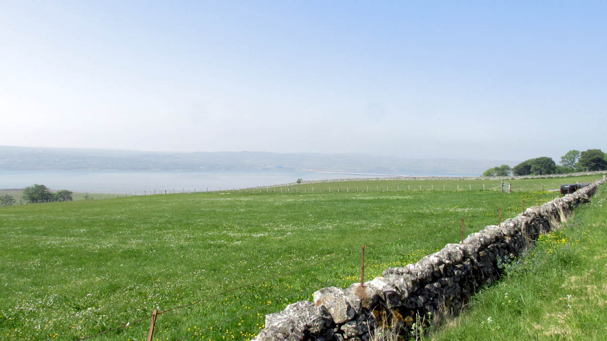
There are a number of souterrains—or “earth houses” as they used to be known—in Sutherland that have been lost. Many have simply fallen prey to being filled-in or covered over. This is one such site, found in the fields between Tongue village heading out towards the sea-bridge crossing the Kyle. In a brief excursion I made to the area a few days ago, I couldn’t locate the site and no one I spoke to seemed to know anything about it. I’m assuming that the site has simply been blocked-up and overgrown, hiding beneath the green pastures above the sea-line.
Its exact whereabouts is difficult to ascertain, for when it was described in Mr Horsburgh’s (1870) excursion to the area, the location he gave for it was somewhat vague, telling:
“Between Tongue House and Kirkiboll, in a field on the right of the road, there is an Eirde house, which I opened for examination (it had often been opened before); it is now about 25 feet long, 2½ feet broad at the entrance, and widens to 4 feet at the far end, where it terminates in a circle; the sides are built with small stones without mortar, and the top covered with large flat slabs.”
This places the location of the souterrain anywhere in the fields between grid-references NC 5904 5815 to the north (near Tongue House) and NC 5901 5678 to the south. If anyone knows anything about this site, please let us know.
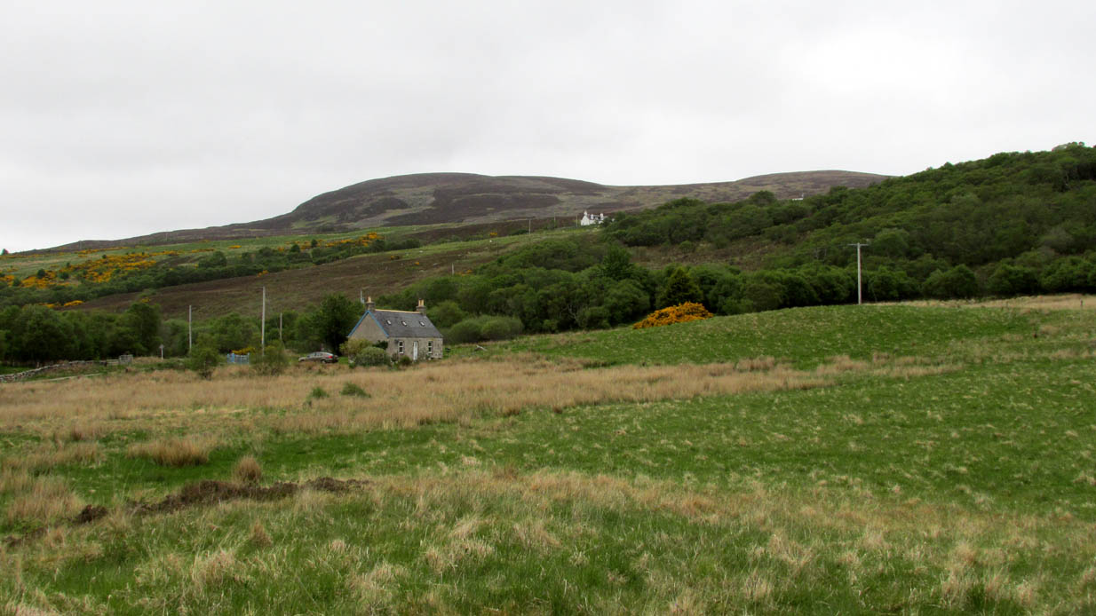
Nothing now remains of the prehistoric underground chamber, “eirde House” (as they were called) or souterrain, that was reported by the northern antiquarian James Horsburgh when he was exploring the sites here in the 1860s. Found near Deanside a couple of miles south of Tongue, alongside the edge of the Allt an Dionaite (Deanside Burn), even in his day there wasn’t much of it left. It was one of a number of souterrains in the region that he was shown, presumably by local people, telling us briefly that,
“Near Deanside, there were remains of the end of another (souterrain) on the bank of the burn, but it has since been washed away in a flood.”
In an exploration up the side of the burn today, I could find no remains whatsoever; although I didn’t walk too far up and have a feeling that its position would have been further up than where I got to. In a brief chat with some of the old people living in the neighbourhood, they told me they had no memory of the site.
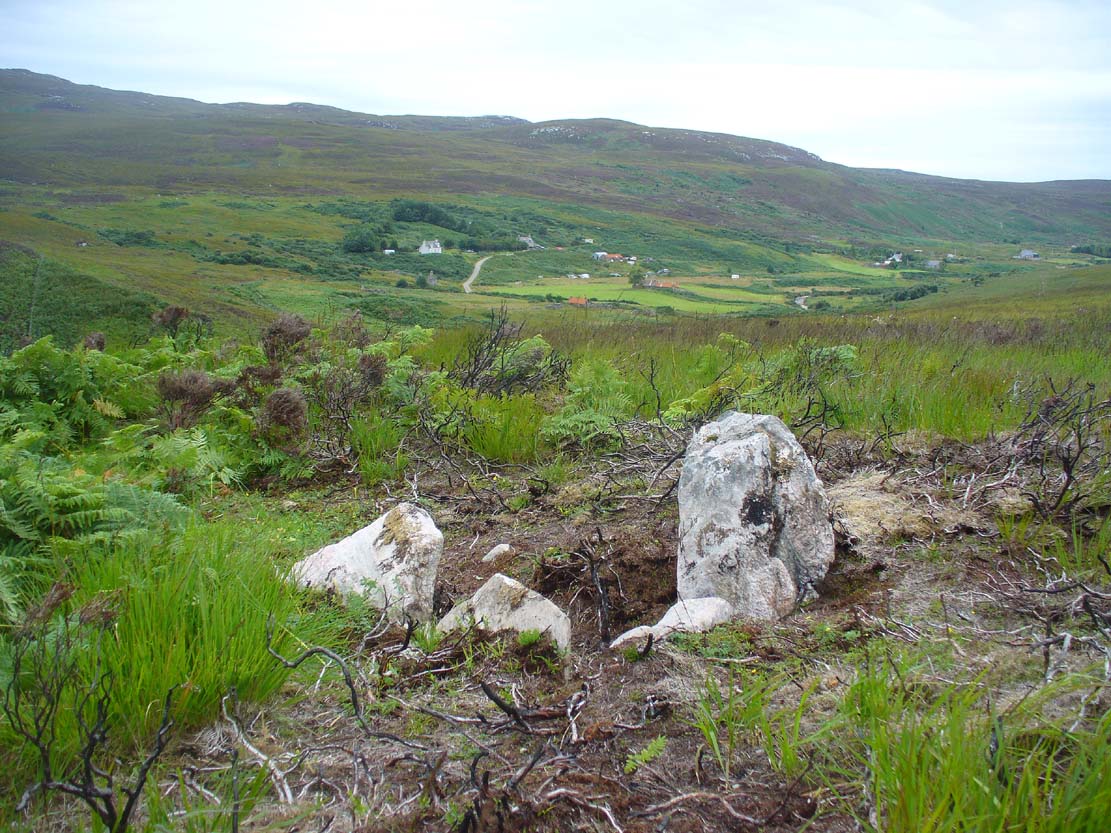
Along the A838 road between Tongue and Durness, just over the Tongue bridge take the first right to Melness, Skinnet and beyond. Pass the previously unrecorded West Strathan petroglyph and go right to the end of the road. Walk down the path and cross the river, heading then up the diagonal path onto the moors. Approaching level ground, look back down to the river and head south across the moorland towards the fence. As you near where the fencing approaches the river, zigzag about and you’ll find it amidst a cluster of bracken in the heather.
Archaeology & History
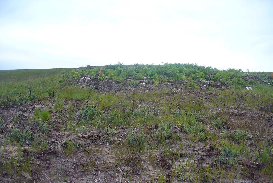
Dalvraid’s chamber, looking W
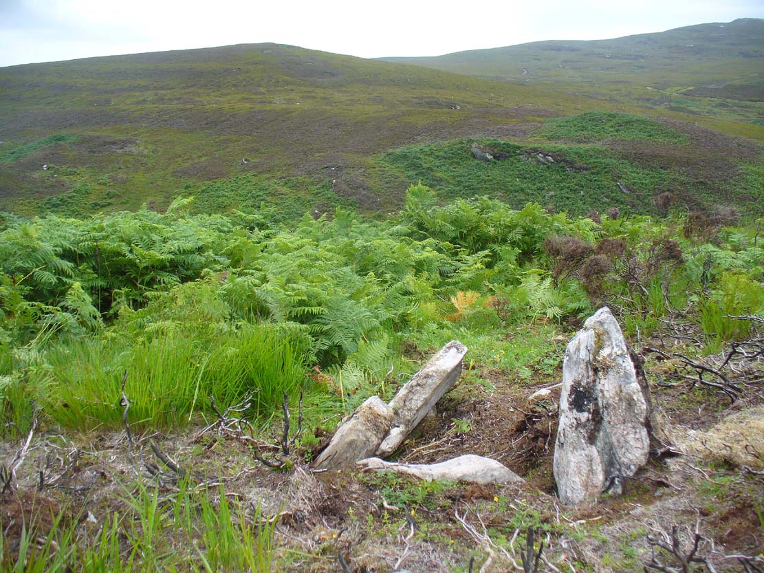
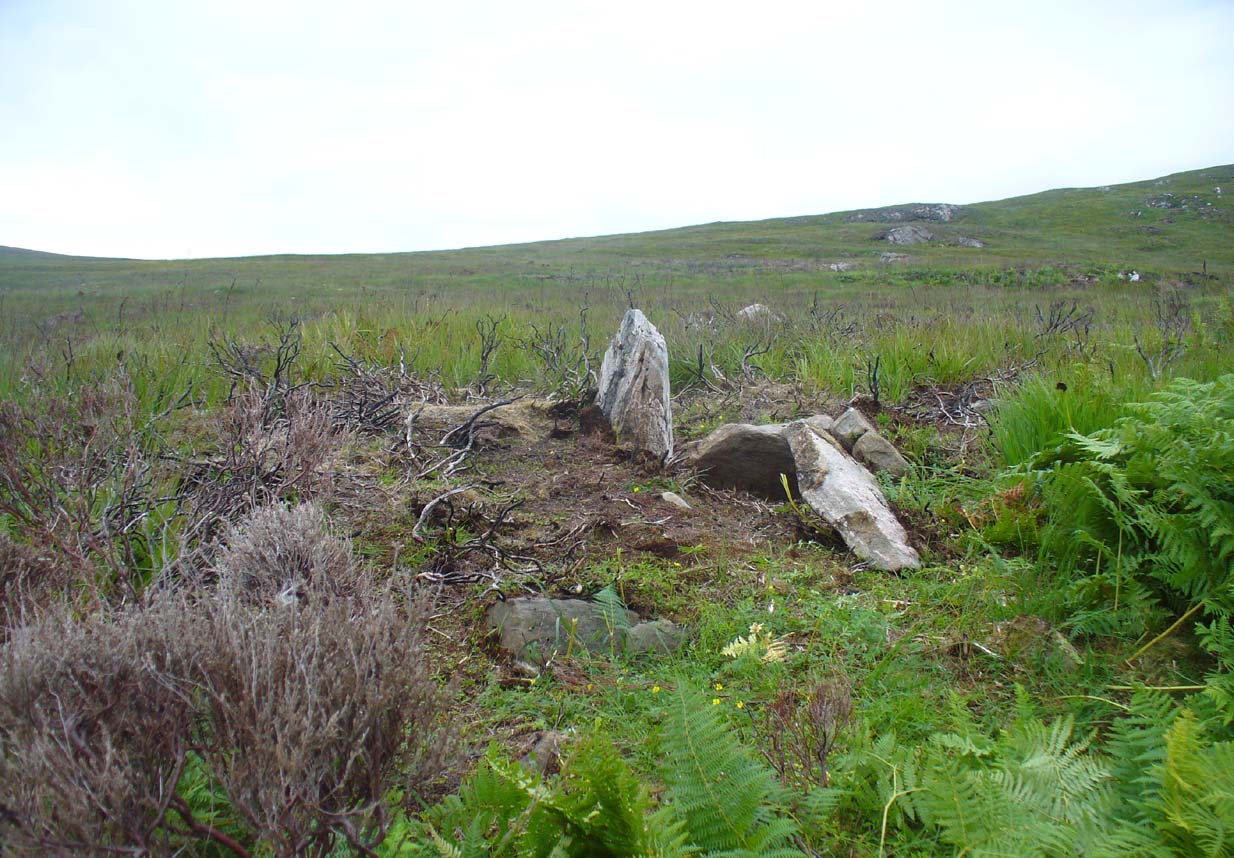
This apparent Neolithic chambered structure is pretty much in ruins and, by the look of things, has been severely robbed of much earth and stone at some time in the not-too-distant past. A relatively small artificial platform of stone and earth in roughly circular form can be discerned when the heather or bracken is low, but much of the large mound that was built here has long since been dismantled. Instead, we have remnants of an internal stone chamber, consisting of a small upright monolith with an adjoining stone roughly at right-angle, with another small but elongated stone running roughly parallel with it – creating a small stone ‘U’-shaped chamber.
When Tom Welsh (1973) came to write about the site, “100m from east bank of Strath Melness Burn,” he described it as follows:
“remains of a circular cairn, diameter 16m, with 8 visible kerb-stones. Perimeter flattened on W side while cairn material curves inwards in the manner of a facade. Leading from this for 4m into the cairn is a slightly curving depression, with two large displaced slabs lying across entrance. 2m further in is a rectangular cist, 1.75 x 0.8m, with 4 slabs in situ. At E end a slab 0.80m long, 0.12m thick has adjoining it at right angles the only slab on the N side, 0.40m long and 0.25m thick. The angle is supported by an embedded stone 0.40 x 0.12m. Forming the S side of the cist are slabs 0.50 x 0.10 and 0.89 x 0.12m. On perimeter of cairn, E side, is a small stone with a socket mark 0.04m diameter 0.025m deep.”
The mound of Dalvraid
Dalvraid’s chamber, looking SE
If you walk away from the remains of this small chamber, you’ll see a scatter of stones here and there around the edges, defining how the cairn used to be. But unless you’re a real chambered tomb fanatic, this isn’t worth too much attention. It almost seems that it will fall beneath moorland debris in the coming century, perhaps never to be seen again…..
References:
Welsh, Thomas C., “Dalvraid, chambered cairn”, in Discovery & Excavation Scotland, 1973
Along the A836 road between Durness and Tongue, take the minor road north to Melness. Keeping to the right all the way along, drive almost to the very end, shortly before which is a double right-hand bend uphill. Park here and walk back along the road, north, past the cottage of Dun Bhuidhe for about 100 yards until you see the large sloping rock face with the telegraph post sticking out of it. That’s the place!
Archaeology & History
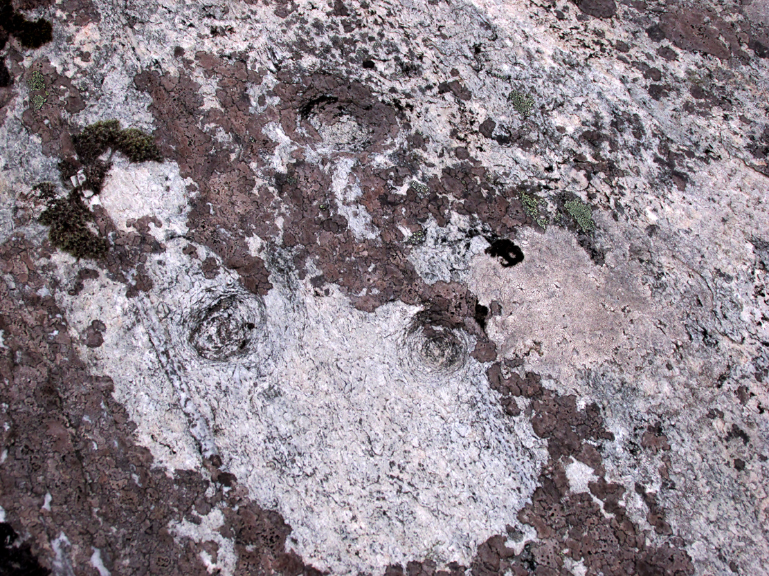
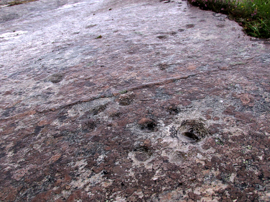
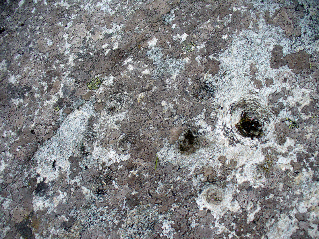
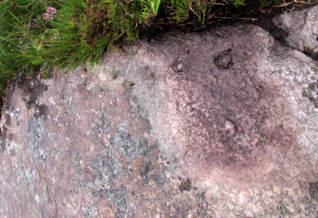
Not previously recorded, this cup-and-ring stone is right by the roadside up the far, lonely but beautiful glen west of Melness, which runs to a dead-end and into the heart of the silent moors high up in Sutherland’s remote landscape — and it’s a damn good one! It’s also the most northern example known of a Neolithic or Bronze Age petroglyph on the British mainland. The carving has been etched onto a large easterly sloping rock, fractured into several sections, with the decayed broch of Dun Bhuidhe rising to its immediate southwest. The setting alone is outstanding!
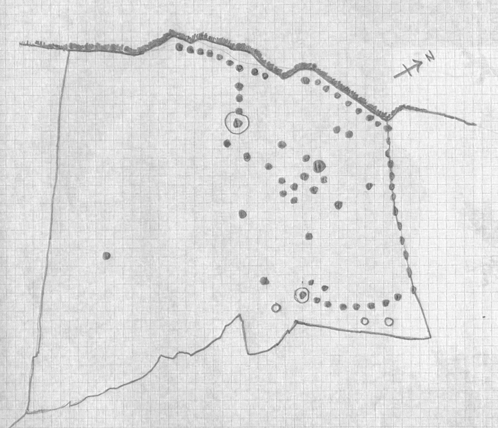
Sketch of the carving3 cups on the lower-east side
It was rediscovered on 25 August, 2015, after Prof Hornby and I had analysed the chambered tomb south of Dalvaid about half-a-mile away. In walking back to explore the aforementioned broch, I cut across the bottom of a nearby rock and found three distinct cup-markings etched near the bottom of its sloping face. Calling out to Prof Hornby, he retreated in his direction to the broch and came back to look at the top of this very large rock surface.
“There are some more cups on this section of the stone!” he called – and began to count them. “At least ten in this little section,” he said. There were indeed!
Carving, looking west
Carving, looking south
By the time we’d finished counting, drawing and assessing the design etched onto the rock surface, amongst at least two cup-and-ring elements we found at least 67 cup-markings, mainly carved onto the northwest portion of the stone. The first three that I’d seen were on the much lower eastern part and were etched in deliberate isolation from the primary design. However, of these three isolated cups, it looks as if one of them may have a spiral element curving out of it. This needs assessing in much better lighting conditions, because when we found it the skies were very grey and overcast, making an accurate survey very difficult (cup-marks on rocks can be hard to see unless daylight conditions are just right) – and, after a short while, the legendary Scottish midges appeared and began to feast on us, which stopped us in our work. The little buggers!
On a subsequent visit here with Sarah MacLean of Borgie in the summer of 2018, she found several more cup-marks beneath the lower arc shown in the above drawing (which I need to update, obviously).
Central features of the carving
Scatter of central cups
The most notable feature to this carving is the arrangement of the great majority of the cup markings. They were quite deliberately carved along the very top of the stone, close to its edge, in two contiguous lines of nine with a small gap separating them. At the northwestern end of this, a very notable feature occurs: a natural crack in the rock runs down the stone and, almost all the way down, we find a line of cups have been pecked onto the stone along the natural crack, with some of them near the top that are unfinished. These cup-marks are more elongated in form than the usual circular status; but this is due to them being etched into the cleft itself. From top to bottom there are 13 such cups. At the bottom of this line, another linear stretch of cups change direction and move back onto the main rock surface, just above another large long natural crack cutting across the rock. This gentle arc of cups (with two other possible cups beneath these) ends at a cup-and-ring, above which are two extra cups next to each other. Above these are a number of other cups of roughly similar size and depth, with a notably large one that gives the impression that the smaller cups around its edges are satellites to its larger parent body.
Line of cups on western edge
Row of cups etched into natural crack
Without any doubt there are other faint features that have been carved onto the stone, but due to the poor visibility factor at the time of its discovery we could not see anything other than the elements highlighted in the rough sketch. In looking through the many photos we took of this carving, there seem to be other faint lines, rings and cups within the overall design, but until we revisit the site (or someone else does!) such further features cannot be added to the drawing.
As the images of this petroglyph clearly shows, the primary feature defining it is the extensive line of continuous cup-markings running along the edges and enclosing a smaller number of internal cups. It’s an unusual element. Sequential line features such as these, defined by cups, are not common. My impression of this feature is that it was a pictorial representation of the horizons, inside which is played the story of….. something… But horizons they seem. Of course, this is a simplistic interpretation and is open to criticisms of any form. I care not! Much more importantly as far as I’m concerned is the fact that we’ve uncovered yet another unrecorded carving – and according to the official records, no such carvings exist here; but where one such carving exists, others are close by!
Watch this space…..
Acknowledgements: Considerable thanks must be given to Prof Paul Hornby, for use of his photos and without whose help this carving might never have been located. Cheers dood!
When I visited this place last year, I had a good look all around for any trace of what James Horsburgh (1870) told us about 150 years earlier, i.e., monoliths that had been broken up and used in the making of the road. Sadly I found nothing. When I enquired about the stones amongst local people, they were unaware of any such site and it had fallen out of oral tradition amongst them. Mr Horsburgh told us simply:
“Near Ribegal there used to be three upright stones, called by the old people a Teampul. They were broken up by Mr Mitchell, the late farmer, and are now built into the dyke at the road side; the hillock on which they stood is still called Croc-tigh-goil, the ‘hillock of the school-house’.”
However, in the fields 300 yards to the north, three large stones are visible—almost in a straight line—but they seem to be Nature’s handiwork; although the southernmost stone looks like it might once have stood upright. But I think I’m being more hopeful than realistic!
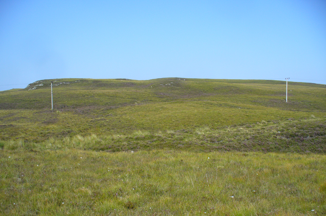
Take the A836 road between Bettyhill and Tongue and, roughly halfway between the two villages, a few hundred yards west of the turning to Borgie, park up at the roadside. Cross the road and through the gate, follow the waters of Allt Loch Tuirslighe for 100 yards and then walk uphill onto the moors. You’re damn close!
Archaeology & History
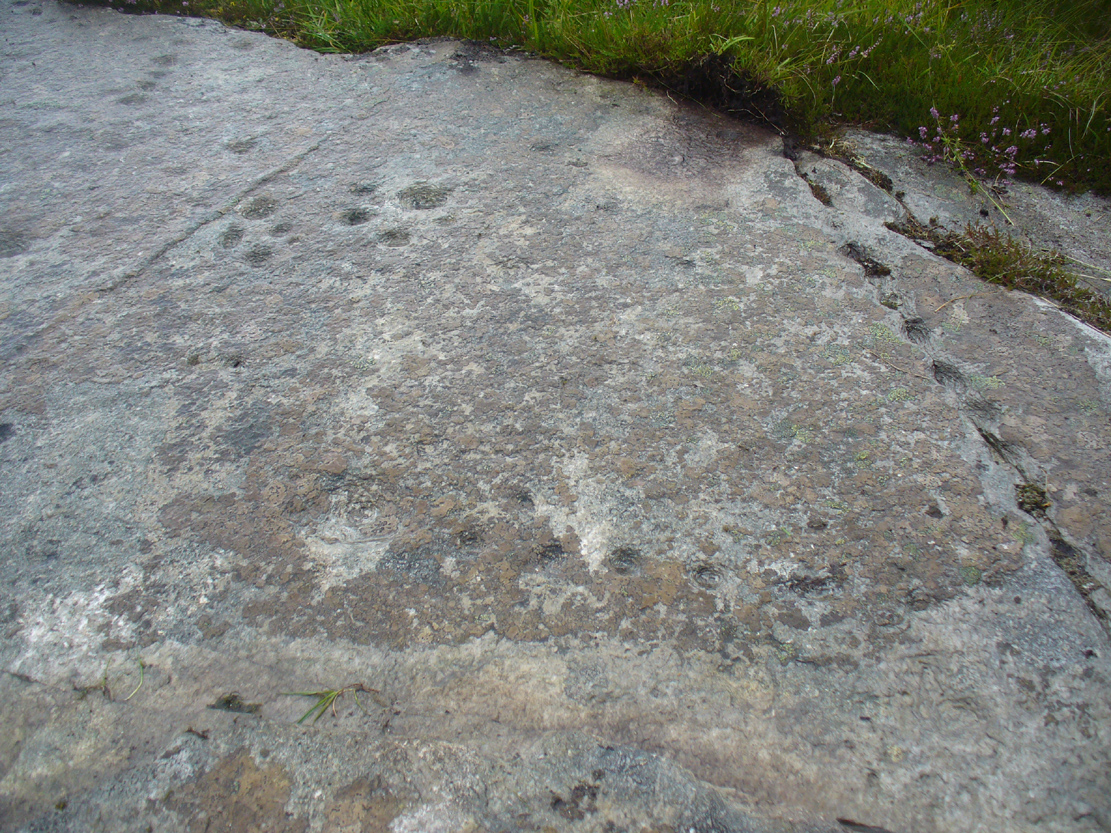
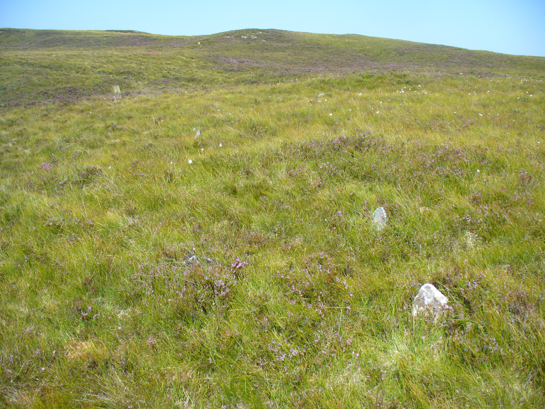
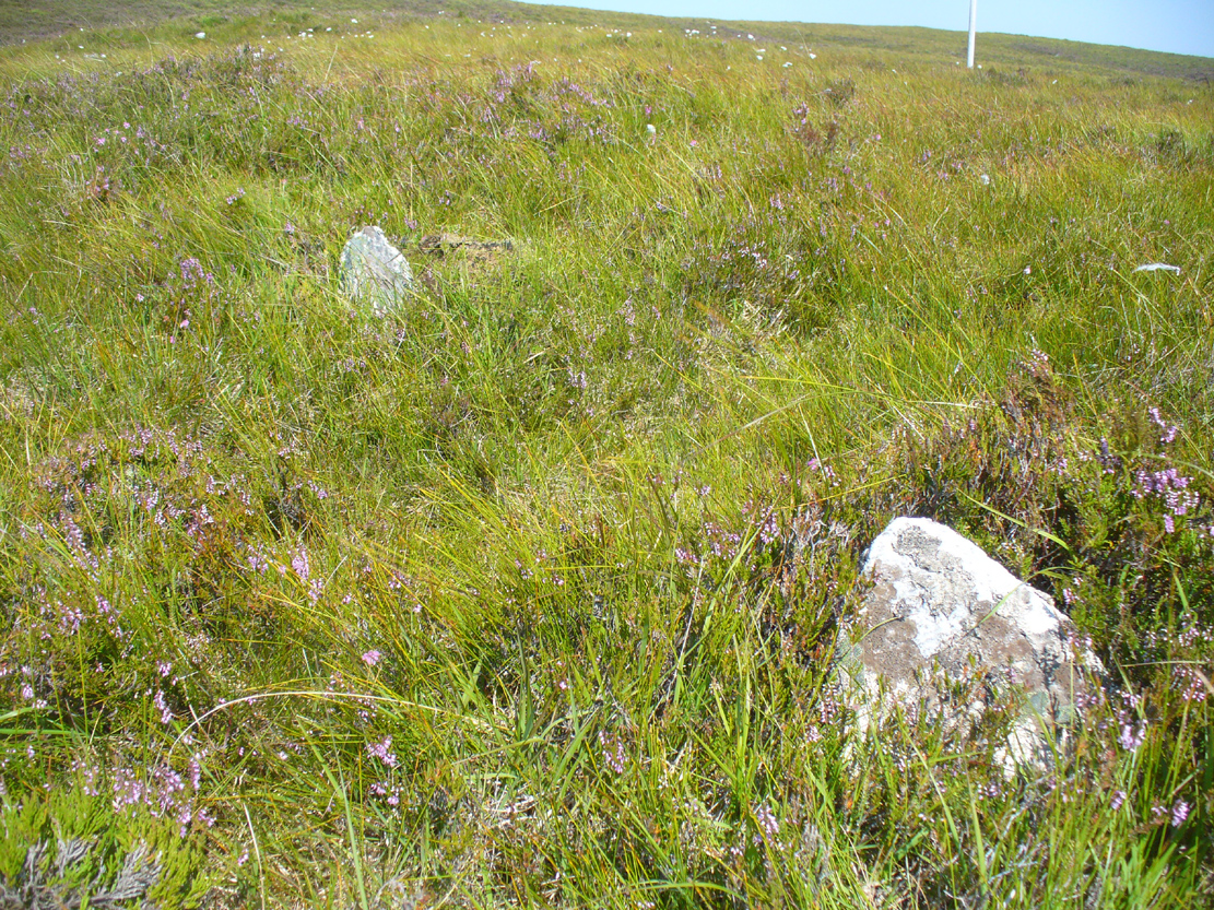
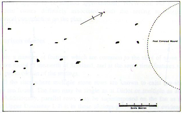
This megalithic stone row was uncovered in the late 1970s – which is no surprise to be honest. It is a very low parallel row of small upright stones, which Freer & Myatt (1982) initially found to consist of two rows of standing stones, twelve in all. When we visited the site a few days ago, I could find only ten of them that could appreciably be termed authentic – and that was stretching it a bit!
Several of the low stones
Close-up of the small stones
Of the two stone rows presently visible, the easterly one is easier to see and consists of seven small stones, running almost in a dead straight line NNE. A few yards west we find the second stone row, in which I could only discern three tangible contenders, also running NNE, but slightly fanning outwards and away further north. When standing in the middle of the two rows, they align to a small natural rocky outcrop on the near-horizon 100 yards away, upon which Paul Hornby recently discovered 3 or 4 faint cup-markings. If we turn 180 degrees and look in the opposite direction, the alignment of stones points to the highest peak in the far distance.
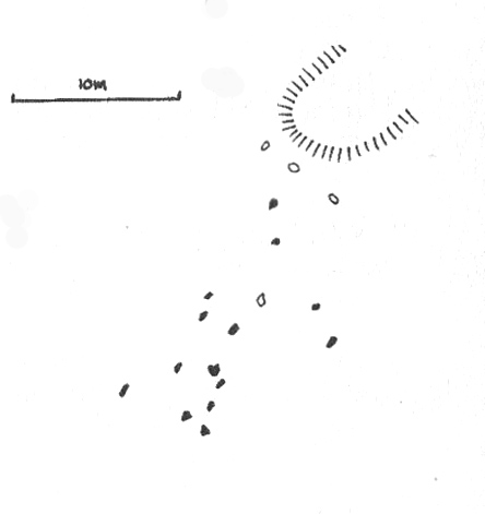
Myatt’s 1988 survey
Gourlay’s 1996 survey
All of the stones are small and difficult to see upon initial exploration. The highest of them stands no more than 1½ feet tall, with their average less than 1 foot. One of the stones in the eastern row is covered completely by vegetation. However, in earlier assessments of this site, quite a few other stones were visible. Its brief history and appearance was described in Leslie Myatt’s (1988) survey of such monuments in this remote region, where he told:
“This very ruinous setting of stone rows was fist recorded by the Archaeology Division of the Ordnance Survey… Peat cutting has taken place in the area and undoubtedly a number of stones have been removed from the site.
“(The illustration) shows the result of a survey carried out by the author showing a total of only 16 stones not more than 20cm above the surface. Because of the small number of stones remaining, it has not been possible to superimpose a geometric construction on the site. The ground slopes upwards to the north-northeast, at which end of the setting is a low peat-covered mound about 10m in diameter. It has no distinctive features, although it does not appear to be natural…”
The site is described in Alexander Thom’s (1990) major survey, but sadly he didn’t turn his direct attention here, so we still have no accurate geometric or astronomical assessment. A few years later Aubrey Burl (1993) gave us details of the larger initial size of the complex and told us that at
“Borgie, near Torrisdale Bay on the north coast of Sutherland, perhaps an early site, has three or four lines with the suspicion of a fifth. The rows narrow from their base 20ft (6.1m) across to 18ft 8in (5.7m) over a distance of 59ft (18m), a contraction as they worm uphill towards a peat-covered mound of hardly a quarter of an inch in a foot (0.6: 31cm).”
The small peat-covered mound which the stone rows lead up to was suggested by Robert Gourlay (1996) as “perhaps a small cairn.”
References:
Burl, Aubrey, From Carnac to Callanish, Yale University Press 1993.
Freer, R. & Myatt, L.J., “The Multiple Stone Rows of Caithness and Sutherland,” in Caithness Field Club Bulletin, 3:3, April 1982.
Gourley, Robert, Sutherland: An Archaeological Guide, Birlinn: Edinburgh 1996.
Myatt, Leslie, “The Stone Rows of Northern Scotland,” in Ruggles 1988.
Ruggles, Clive, Records in Stone: Papers in Memory of Alexander Thom, Cambridge University Press 1988.
Thom, A., Thom, A.S. & Burl, Aubrey, Stone Rows and Standing Stones – 2 volumes, BAR: Oxford 1990.
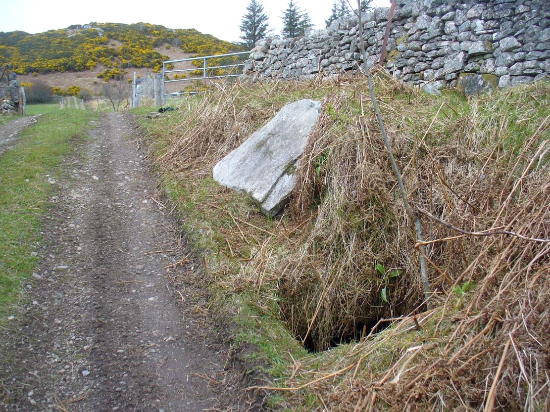
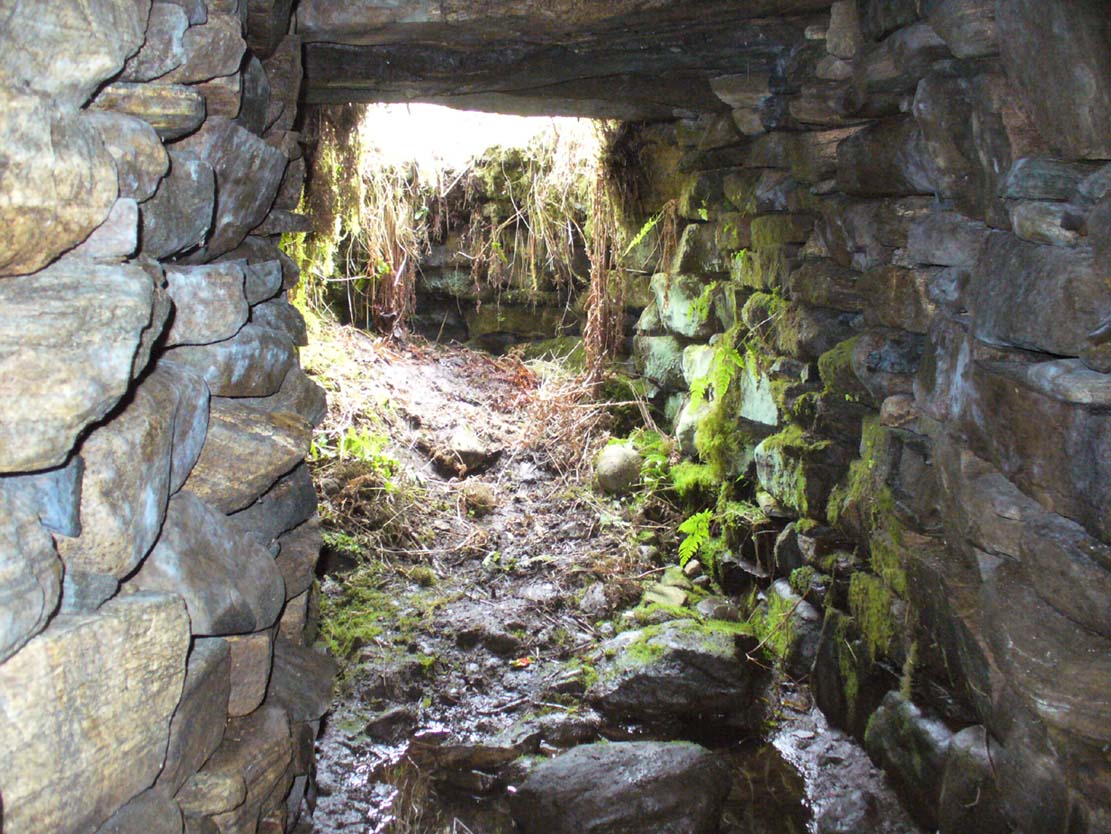
From Bettyhill village, take the A836 road west towards Tongue. Several miles along the road, keep your eyes peeled for Borgie and Skerray on your right. Go down here for half-a-mile or so until, a hundred yards or so before the Borgie Hotel, a dirt-track on your right takes you down into some trees. As you enter the edge of the woodland, right by the trackside on your left, a large stone lays in the grass. A few yards from this is the hole in the ground.
Archaeology & History
When I was first shown this place, I could find no previous description of it in any of the archaeological records. I was fortunate in being taken here by one of the land-owners hereby, who told me that it had been known about locally for some years – but informing the archaeologists (patronizing as they were to the people hereby, as can be the case sometimes) was the last thing on their minds….
Entrance to an underworldLooking out from inside
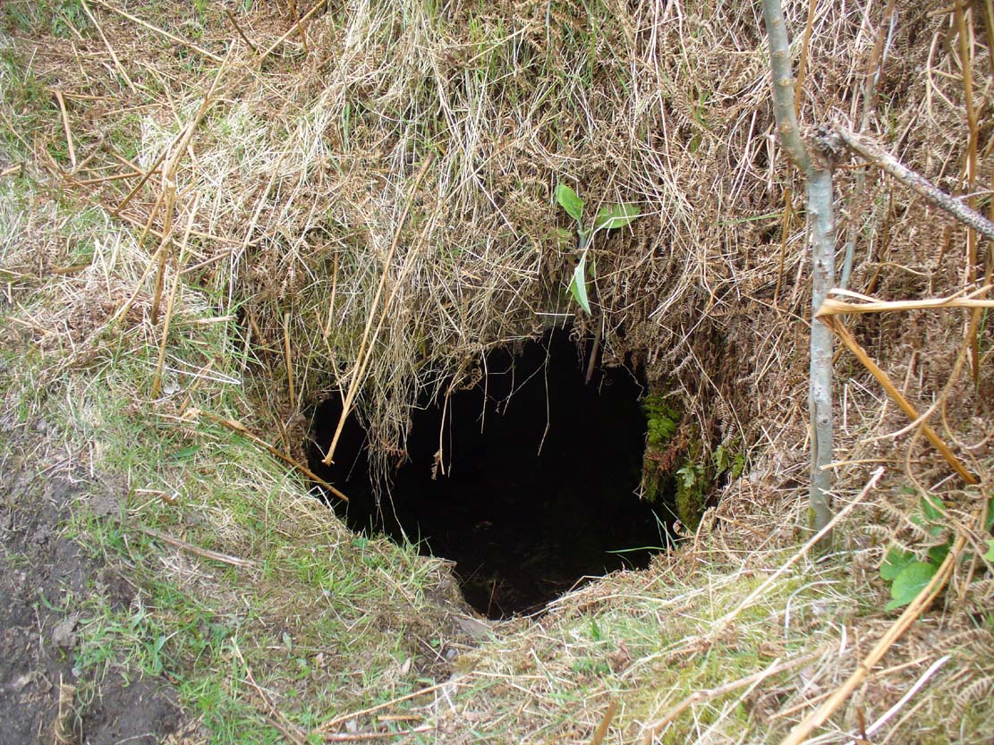
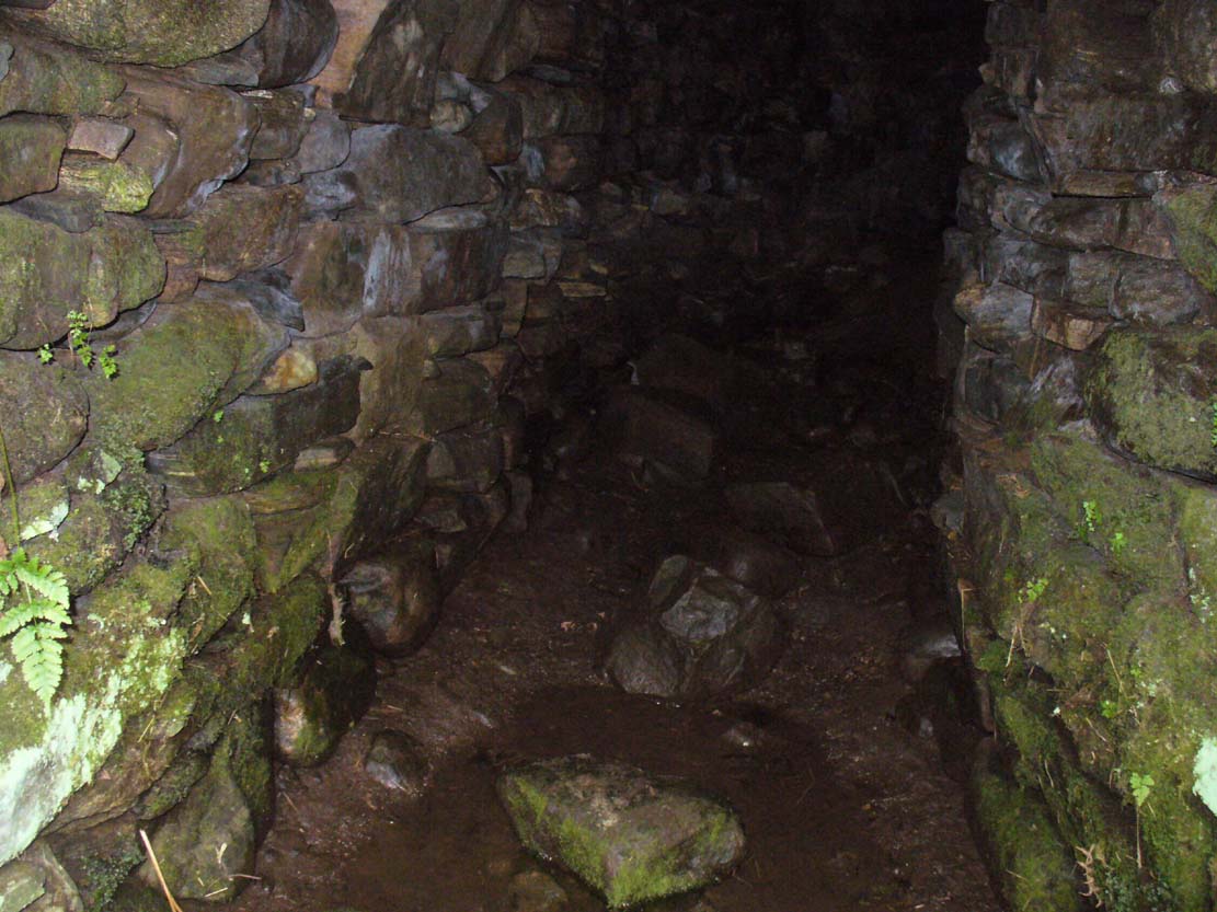
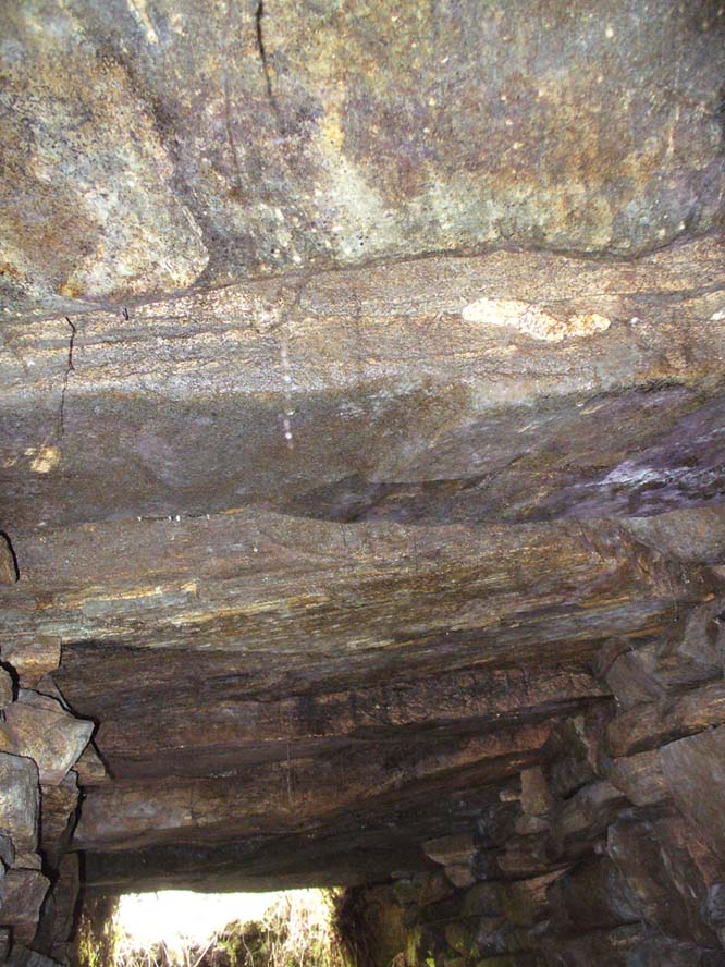
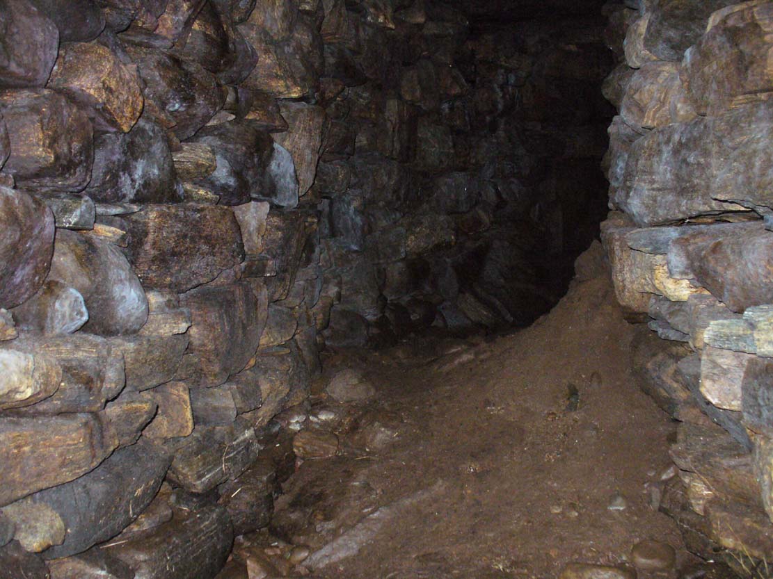
Immediately beneath the ridge where the Borgie chambered cairn once stood, the site was uncovered quite by accident when a local man went to move a large stone on the grassy embankment, to make use of it in walling or something similar. But much to his surprise, the boulder covered the entrance to an underground chamber known as a souterrain – inside which, local lore tends to tell, the little people once stayed. It’s an impressive structure! When Donna Murray took me to see this a few months ago, she said it was only a few yards long – but once I’d got inside, found it to be much longer than this. After dropping perhaps six feet down into the hollow, the very well-preserved wide chamber beneath – some 6-8 feet across – curved around to the north-northeast and into pitch blackness. I walked perhaps ten yards into the chamber, completely upright, and as the chamber curved and went further into the Earth, the pitch black stopped me venturing more.
Looking into the darknessLine of roofing stones
The walls of the souterrain were very well structured indeed and were made up of hundreds of good-sized stones, akin to those used to build old stone walling in our northern hills. The floor was, typically, muddy and apart from a scatter of a few stones I could see little by way of a ‘floor’ beneath my feet (but it was dark!). However, the roofing was made up of large flat stones measuring 6-8 feet across, as wide as the structure itself, running parallel all along the chamber. I did not walk to the end of the chamber – but would assume that this roofing continued to the end of the souterrain.
In a number of souterrains we find examples of cup-and-ring carvings (the one at Pitcur, Perthshire, being one of the very best), but I could discern no such petroglyphs inside this chamber. However, considering how dark it was, another investigation with torches is necessary before any definitive remarks regarding internal petroglyphs can be made.
Curving into the darkness
It’s in damn good condition indeed and is well worth looking at if you venture this far north. Other unrecorded prehistoric monuments are found all over this remote landscape – from cup-and-rings, to stone circles, to tombs, enclosures, cairns, you name it! If anyone knows of any permanent rental properties up here – please let me know and get in touch so that I can spend the rest of my life working here meandering, discovering and recording the prehistory of this truly archaic landscape! I’m serious!
Acknowledgements: Immense thanks to Donna from Borgie, for showing me this ancient monument and other sites.
A singular reference to this site appears in James Horsburgh’s (1870) early article on the prehistoric remains of Sutherland. It seems he was on an early road-trip (or dirt-track-trip as it would have been in those days, as there were no real ‘roads’) and as his journey took him along the remote tracks in the far North, visiting places that are still intact and mentioning those which, oral tradition told, had passed into memory, local folk told him about a couple of brochs that had recently met their demise. This was one of them. He wrote:
“Between Farr and Tongue, after crossing the Naver Ferry… some miles on, near Borgie-farm house, there was a Pictish tower, now demolished, and on the side of the old road to Tongue, another.”
In asking the lady who lives here if she knew anything about the broch, she told that although she didn’t, she’d ask some old locals to see if they knew of any folk remnants about the place. It would have stood a short distance above the little-known Borgie souterrain. If we receive any additional info, the site-profile will be updated. (the grid-reference for this broch is an approximation)
Very difficult to find under the herbage, but – along the A836 road between Tongue and Bettyhill, turn down at Borgie Bridge towards Skerray. A few hundred yards along, past the third house on y’ right, a path through the gate on the left takes you up the slope. Once you meet the deep-cut dike, follow it north-ish for 200 yards, over the fence; then walk 150 yards towards the eastern edges where the mass of gorse meets with the rocky escarpment. You’re damn close!
Archaeology & History
These days, much of the remains of this neolithic chambered cairn are inaccessible, as it is covered with the spindly-killer-bushes that are the yellow gorse (Ulex eurapæus). A pity. …Just like its fellow chambered tomb of Dun Riaskidh precisely 1½ miles NW, this was also built upon the edge of a natural rocky escarpment with some of the rocks making up the tomb falling to the edges (I nearly fell in and spined misself meandering around its edges!).
Little has been written about it in archaeo-tomes, despite it being first listed in 1947. Presumably neolithic in age, it was first classed as a ’round cairn’ and has subsequently been described by Canmore as,
“a severely robbed, chambered cairn. It is about 15.0m in diameter, with a maximum height of 0.6m in the centre; elsewhere the cairn is reduced to a stony rim and scattered stones. In the centre a chamber is indicated by two opposing earthfast boulders 1.1m apart and protruding up to 0.6m through the cairn material.”
References:
Gourley, Robert, Sutherland: An Archaeological Guide, Birlinn: Edinburgh 1996.
Acknowledgments: Huge thanks to Donna Murray, for putting me up in this part of Paradise. Cheers Donna.
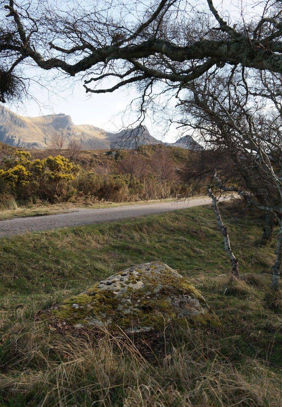
Whether you take the A836 or A838 into Tongue (through truly beautiful wilderness), make sure you go into the village itself—and then keep going, south, along the tiny country road for 3 miles. Hereby, keep your eyes peeled for Lochan na Cuilce on your right; keep going past here, into and through the old trees where you’ll then see Lochan Hakel on your left. Keep going past here until your reach the next small copse on your right. Stop here. A small pool is yards into the trees and here you’ll see a single stone between that and the roadside. You can’t really miss it!
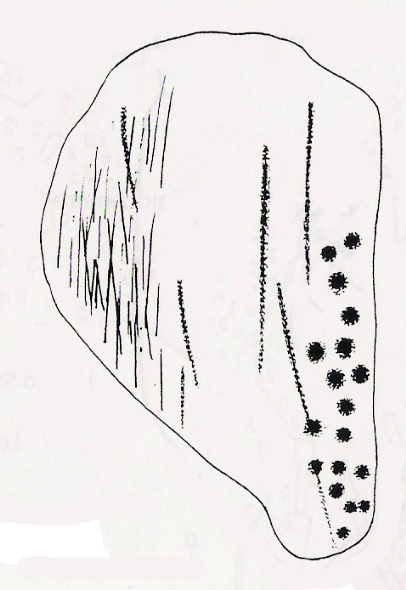
Archaeology & History
Close-up of some cups (by Donna Murray)
An apparently isolated cup-marked stone, some 3 feet by 5 feet, that was first described in Morrison’s (1883) meanderings amidst Sutherland’s awesome wilderness. It’s quite plain compared to Lochan Hakel 2 and many other carvings, simply consisting of 18 cups of various sizes, mainly on the eastern side of the rock. Sarah MacLean pointed out that a line running along the length of the stone seemed, in parts, to have been artificially enhanced by the hand of man, or woman. I have to agree with her.
The Royal Commission (1911) lads included this petroglyph in their superb survey of Sutherland, telling:
“On the W. side of the road to Kinloch, about ½ m. N of the bridge over the Kinloch River (Amhainn Ceann Locha), and on the N edge of a gravel pit close to the road, is a large earthfast boulder, 5′ in length as far as exposed, and 3′ 10″ in breadth, showing on its upper surface eighteen cup-marks of various depths, of which the most distinct is towards the N end of the stone, measuring about 3″ in diameter and 1″ in depth. The whole length of the stone is not visible, but the markings do not seem to extend to the portion covered…”
Carving in situ (by Donna Murray)by Kevin o’ Reilly
Simulacra lovers will love the form of this stone in relation to the background of the mountains, as its shape is echoed in that of the rising hills several miles to the south. …Of course, the depersonalizing ones amongst you lacking an understanding of animism would reject any such association due to your projection of disbelief. However—and equally—as we lack any ethnographic data on the carving we must also assume some caution…
A fascinating site – and one which is likely to have neighbours hidden in the surrounding moorlands…
References:
Gourlay, Robert, Sutherland: An Archaeological Guide, Birlinn: Edinburgh 1996.
Michell, John, Simulacra, Thames & Hudson: London 1979.
Morrison, Hew, Tourist’s Guide to Sutherland and Caithness, D.H. Edwards: Brechin 1883.
Royal Commission on Ancient & Historical Monuments, Scotland, Second report and inventory of monuments and constructions in the county of Sutherland, HMSO: Edinburgh 1911.
Acknowledgments: Huge thanks to Donna Murray for use of her photos in this site profile (aswell as for putting up with me whilst in the area); and also to Sarah MacLean for taking us to the carving in the first place. Many many thanks indeed. See y’ again soon, hopefully!