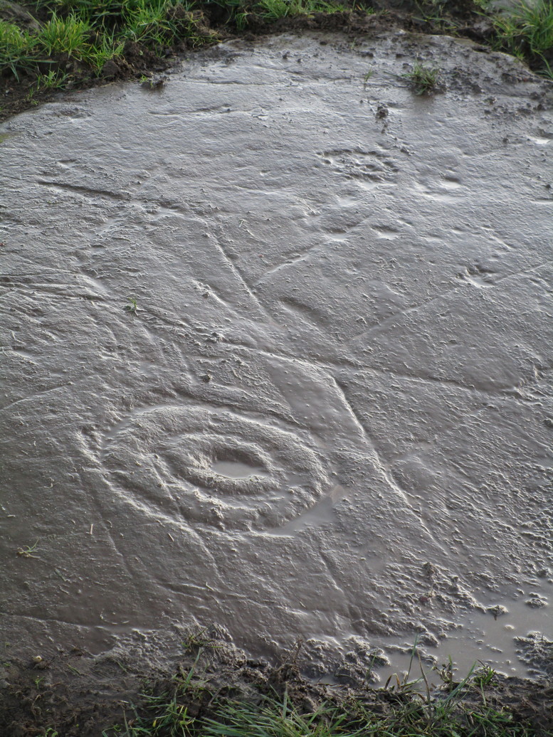
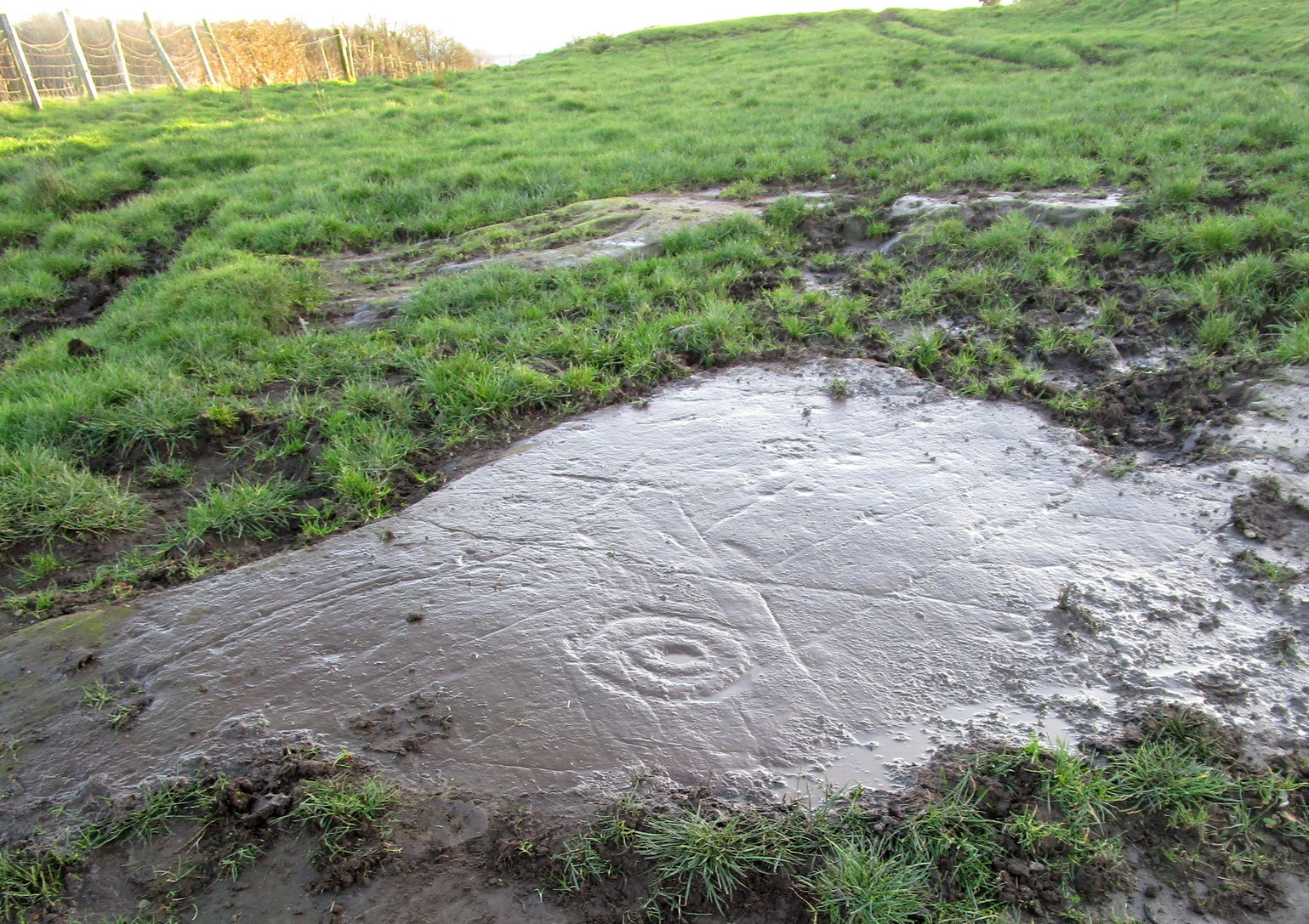
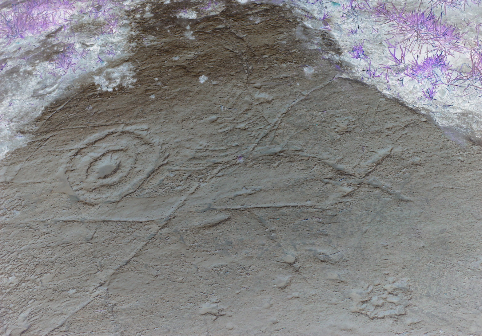
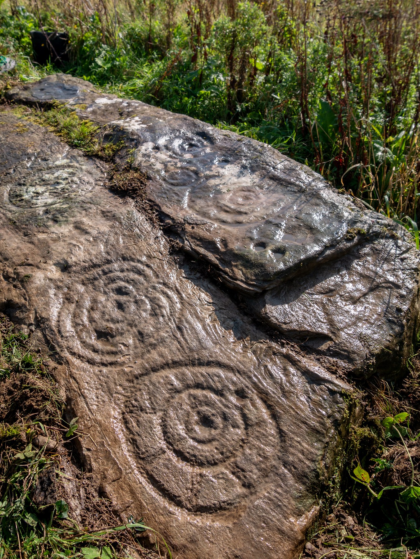
Amidst the cluster of at least twenty petroglyphs found at Castleton, this example close to the fence 60 yards southeast of the farmhouse, wasn’t included in the earlier surveys by Morris (1981) and van Hoek. (1996) At this spot there a large smooth sloping rock broken into separate parts with natural cracks running over it at different angles, partially covered in soil. The stone faces north. On the easternmost side there exists a number of carved symbols, most notable of which is a large double cup-and-ring. You can’t really miss it! The other elements however, can be a little more troublesome to see…
Cup, rings & crossCastleton 11 carving
A curious motif is the quite notable ‘cross’ that’s been pecked onto the stone, above the primary cup-and-ring. This cross is probably a later addition to the petroglyph, perhaps added to christianize the original mythic function. From the cross, it looks as if a curved line has been carved down towards the double-ring, nearly linking them together, which could also be viewed as a movement from the pre-christian to the new christian meaning conferred upon the stone. …Just an idea…
It should be noted that a faint cross was also cut into natural cracks in the Castleton 2 carving, 380 yards northwest of here.
There are two more cup-and-rings on the stone, both on the right-hand side of the cross. These were carved quite separately over large periods of time, as evidenced by their degrees of erosion. One cup-and-ring (if you can call it that) is a somewhat erratically executed series of peck-marks that strives to join up with each other, almost failing miserably, creating a somewhat disjointed cup-and-ring. Next to this, but much much fainter, is a cup-and-half-ring that was obviously carved decades, if not centuries earlier. You can just make them out in the two photos here, to the right of the cross.
Carving in negative
Another very faint cup-and-half-ring also exists to the left of the primary motif that was only visible from one or two angles when we visited the place the other day, but barely shows up on any of the photos we took. There are a number of single cup-marks, mainly between the double-ring and the smaller cup-and-rings, some of which are probably natural, but several seem to have been worked upon by human hands.
A now-hidden petroglyph—known as “Castleton-3” in the Morris and van Hoek surveys—consisting of multiple cup-and-rings, exists beneath the mass or gorse bushes about forty years to the southwest. We could do with cutting this back so we can see the carving again.
References:
Morris, Ronald W.B., The Prehistoric Rock Art of Southern Scotland, BAR: Oxford 1981.
van Hoek, M.A.M.,”Prehistoric Rock Art around Castleton Farm, Airth,” in Forth Naturalist & Historian, volume 19, 1996.
Cup-and-Ring Stone: OS Grid-Reference – C 30754 37541
Archaeology & History
Incredible setting -incredible carving
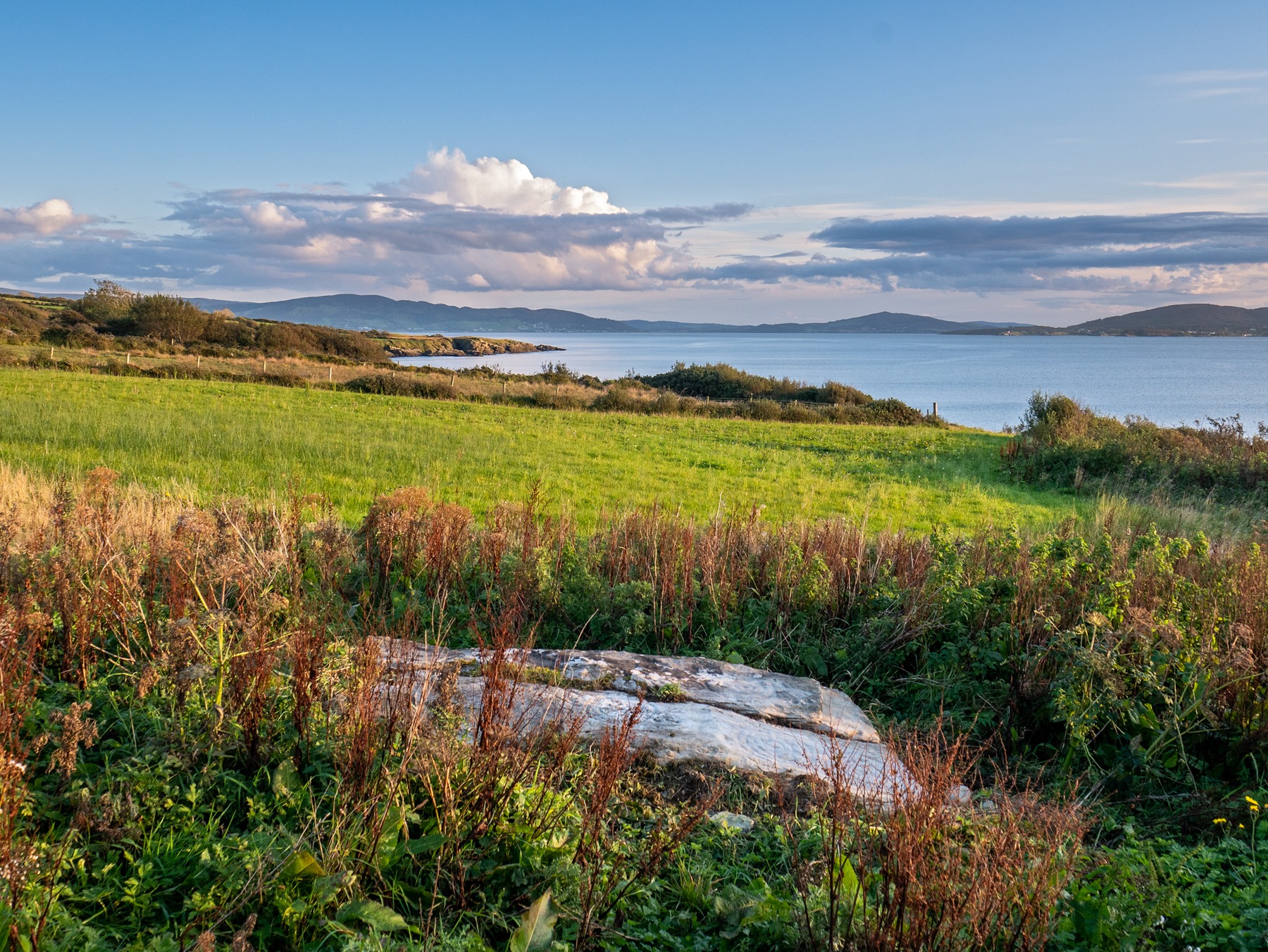
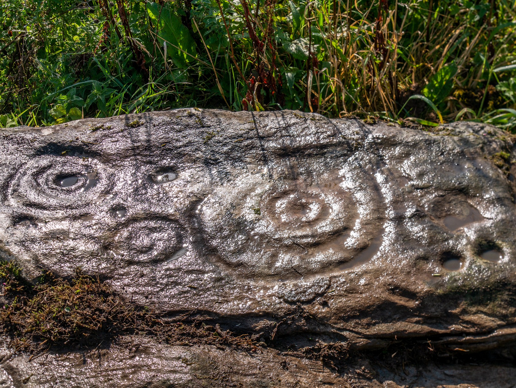
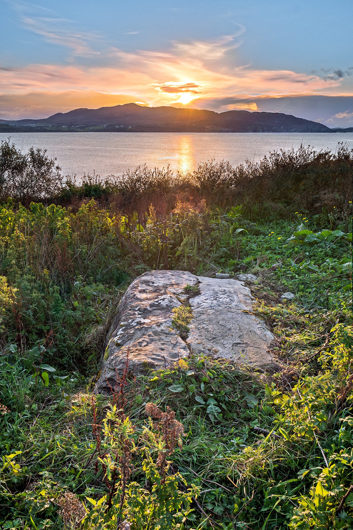
This is an incredible find—dare I say a beautiful find—uncovered beneath the soil a few years ago on farmland close to the shore of Loch Swilly by one of the farm-workers. We were lucky inasmuch as when it was found he noticed curious markings on it. Informing the farmer, between them they peeled back the rest of the soil and found the incredible carving that we see here in Bettina Linke’s photos.
Etched onto a sloping stone overlooking the blue panorama that is Loch Swilly, this petroglyph has a 180º view of the landscape, from the southeast through to the northwest. This panorama—unimpaired by trees thanks to its proximity to the sea loch—was probably an important ingredient in the mythic function of the carving and is something we’ll return to shortly…
Local rock art specialist, Liam McLaughlin was informed of the discovery and, along with Bettina Linke, they met up with the farmer who showed them the carving. I have little doubt that they were very impressed by what lay before their eyes! They told that the rock,
“is aligned east-west with the visible motifs, apart from a few cup marks, situated at the western end of the outcrop. Interestingly, the northern half/leaf is little worn and individual peck marks, made millennia ago, are clearly visible, suggesting it may have been covered for most of the time. The southern half is clearly worn and smoothed out and therefor appears to have been exposed for a considerable amount of time.”
Archetypal cup-and-ringsAncient solar motif?
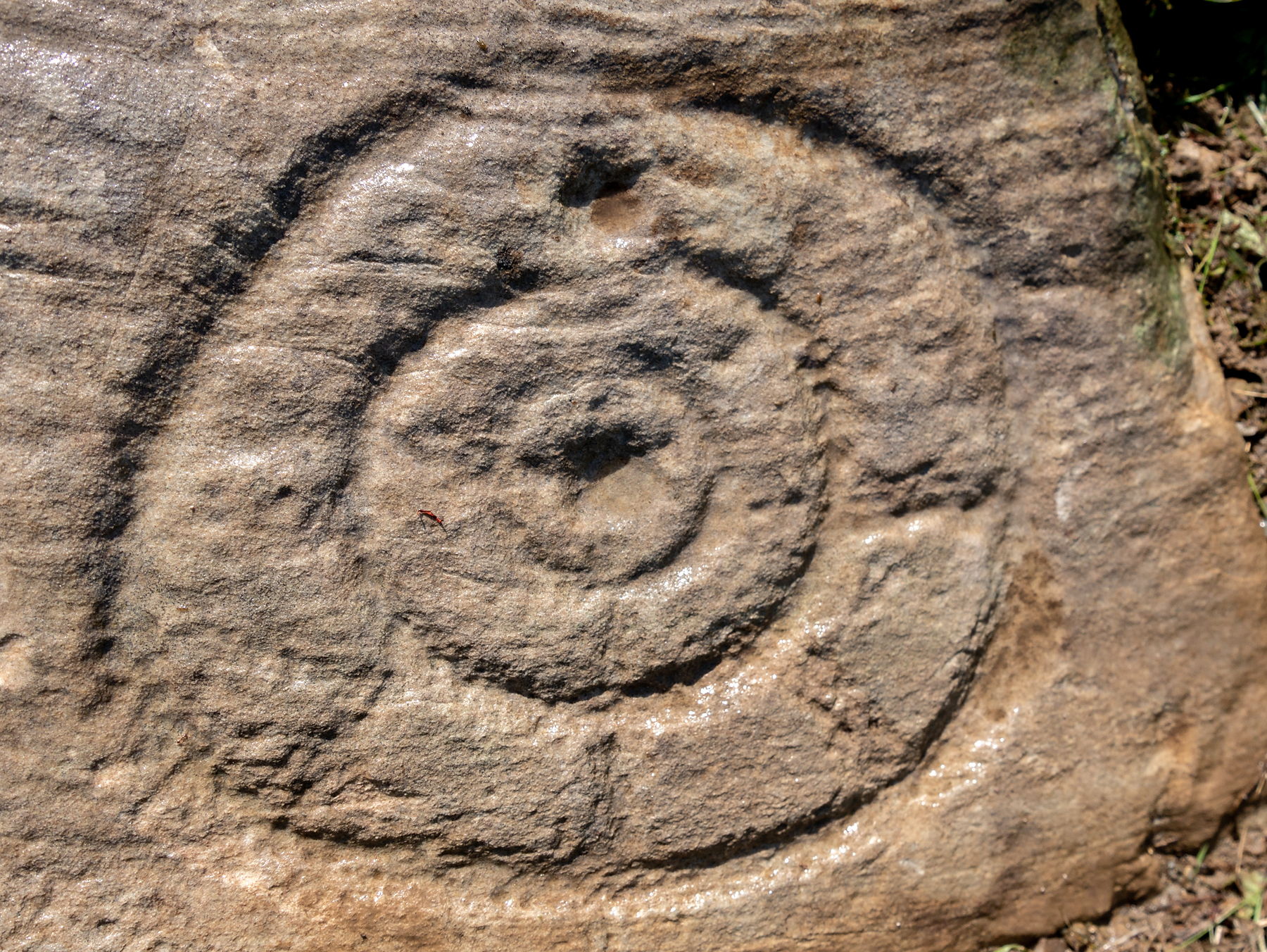
One of the most impressive elements in the overall design is the solar motif, i.e., a series of concentric rings (in this case three) with a number of ‘spokes’ reaching outwards as if to indicate the rays of the sun itself. This is shown clearly in one of Bettina’s photos here. This symbol is found on other neolithic carvings in Ireland: not least the incredible designs in the Newgrange complex where the solar alignment is unmistakable.
The discovery of the carving was reported to the Irish National Monument Service and added to the Heritage Environment Inventory where a detailed report was subsequently written, much of which is extracted here:
“The rock art panel is on an outcrop of bedrock, aligned east to west and slightly sloping in this direction towards Lough Swilly and Knockalla Mountains, also known as the Devil’s Backbone. It lies in an arable field near a field wall in rough ground. Visibility is good to the SE, S, W, and NW across Lough Foyle and the Fanad peninsula.”
On the northern section of the stone,
“There are three large motifs and well preserved with cup and pecking marks between them. There are traces of a fourth large motif on the east end but the rock surface has been eroded or damaged, making it impossible to ascertain the design of the motif.
“Starting from west to east, the top large motif has three rings and a diameter of 43cm. The centre cup mark is shallow and has a diameter of 5cm. There is second shallow cup mark between the 2nd and 3rd ring in the southern part of the motif. Its diameter is 3cm. One tail, is running from the inner ring outwards to the west and a second one is running towards the north. Peck marks, covering the motif, are still visible, particular in the rings.
“The motif below has four rings and a diameter of 39cm. The centre cup mark is very shallow and has a diameter of 4cm. And like in the above motif it has a tail running northwards. But a special mentioning has to be made of the unusual heart shape of its rings with the indentation to the south. Peck marks are still visible in the rings. As far as could be made out, there are five cup marks between those two motifs with diameters between 3cm – 5cm. This part also contains several single peck marks of about 1cm in diameter.
“The next large motif below has a diameter of 37cm, three rings and a centre cup with a diameter of 3cm. A tail appears to divide the motif into an eastern and western half. Another tail seems to run from the centre cup through the inner and middle ring towards east.
“Large peck marks of 1cm diameter cover the entire motif, which can be particular well seen in the embossed space between the middle and outer ring. There are more, large peck marks above the motif to the west as well as four possible shallow and small cup marks. Although the two closed to the motif, in what appears to be a twin configuration, could be two independent but slightly damaged peck marks.
“All of the three motifs on the northern wing leave the distinct impression that they may have been sun wheels with some spokes no longer visible or not visible during our visits.
“The southern wing:
“Like the northern ring the large motifs are placed in the western end of the wing with only a few cup marks on its eastern tip. The edges of the carvings are rounder and more worn, although some rings and cup marks are distinctively deeper. The latter might suggest that these motifs were carved at a different time and by different hands. It also appears that this wing was longer exposed than the northern one.
“The motifs are as followed from west to east: two deep cup marks on the northern side. Diameter for the upper one 5cm in diameter, for the lower one 4cm. There could be a shallow third one below and a damaged one to the south.
“Next in the centre of the wing is a large, three ringed motif with a diameter of 40cm and a centre cup mark, 3.5cm in diameter. Some of the photos show possible if faint tails or spokes, suggesting that this also could be a sun wheel motif. No visible peck marks. Below is a small double ring motif with a diameter of 17cm and a centre cup mark with a diameter of 2cm. Just below and to the south-east is a cup mark, circa 3 cm in diameter. Beside it to the east another cup mark about 5cm in diameter. There are one or two, maybe three circa 2.5cm cup marks in the white lichen area to the north-east of the small ringed motif. And some faint peck marks appear between the large 3 ring motif above and the small ringed motif close to the natural split of the bedrock. The next motif below is a deep double ring motif with a diameter of 26cm and a centre cup mark of 5cm. No tails or spokes could be detected. The white lichen area with up to three possible single cup marks is just beside it, close to the natural dividing crack.
“In the middle of the southern wing are faint traces which suggest that there could have been another motif, now destroyed, of an estimated diameter of 28cm.
“The eastern tip has one large cup mark of 10cm and 3 small cup marks between 2.5cm and 3cm. There might be a fifth but damaged cup mark.”
Somerville’s astronomical linesThe setting sun: a mythic function?
The fact that the stone itself is aligned east-west and pointing towards the outline of the Knockalla Mountains, suggesting “a solar/sunset alignment at the equinoxes” may well be true, but whether this was intended or not is another matter.
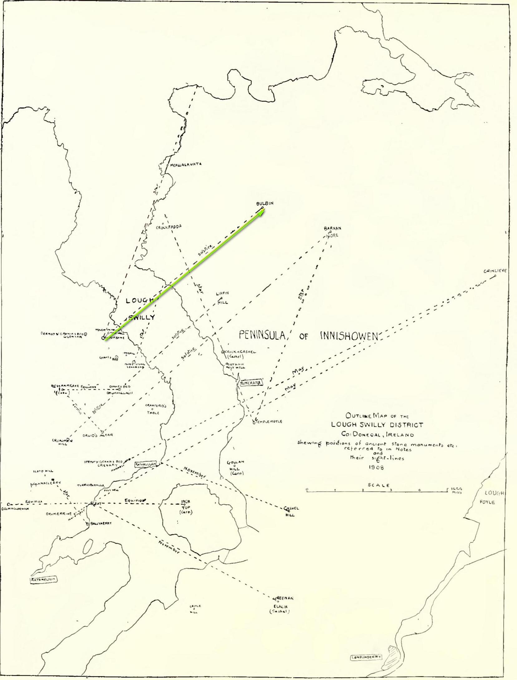
Intriguingly, one of the archaeo-astronony pioneers, Boyle Somerville (1909) wrote a article in the Journal of the Royal Society of Antiquaries of Ireland about a number of summer solstice alignments he thought existed in this precise locale. Amongst them was one he found running from the standing stone at Cloghbane on the other side of Loch Swilly—known as the White or Rowan Stone—heading northeast to the small mountainous peak of Bulbin, approximately 7.1 mile away. Somerville found that,
“The outline of the mountains visible to the northward from Cloghbane shows two sight-lines that undoubtedly were used from this position. One is for the summer solstitial sunrise over the prominent peak Bulbin; the other is over a low and small but conspicuous round-topped headland, towards the mouth of the Lough, which is in line with an exactly similar hill behind it; their two summits being practically coincident, forming a single sky-line; so that, from Cloghbane, their angle of elevation by theodolite is the same.”
The primary motifs
The first alignment is the relevant one here: it not only relates to the rising sun at solstice in 1000 BC, but our Glebe petroglyph lies right on the edge this alignment! (give or take a few yards) Whether or not this is a coincidence we cannot say for certain, but the ‘solar motif’ in the design would seem a strong indicator that implies some sort of solar function here.
As always with cup-and-rings, their non-linear designs tickle our minds with possibilities, probabilities and that there thing called the mysterious, which Einstein described as “the source of all true art and science…”
One final and important thing to anyone who may want to visit this site: please contact the farmer and ask his permission if you want to see it. Cheers. 😉
Acknowledgements: Massive, huge huge thanks to Bettina ‘Grianan Swilly’ Linke for the superb photos and data for this site profile. And (although he doesn’t know it yet!) thanks are also due to the farmer and his employee who rediscovered the carving and to Liam McLaughlin who put pen to paper and told the rest of us about it.
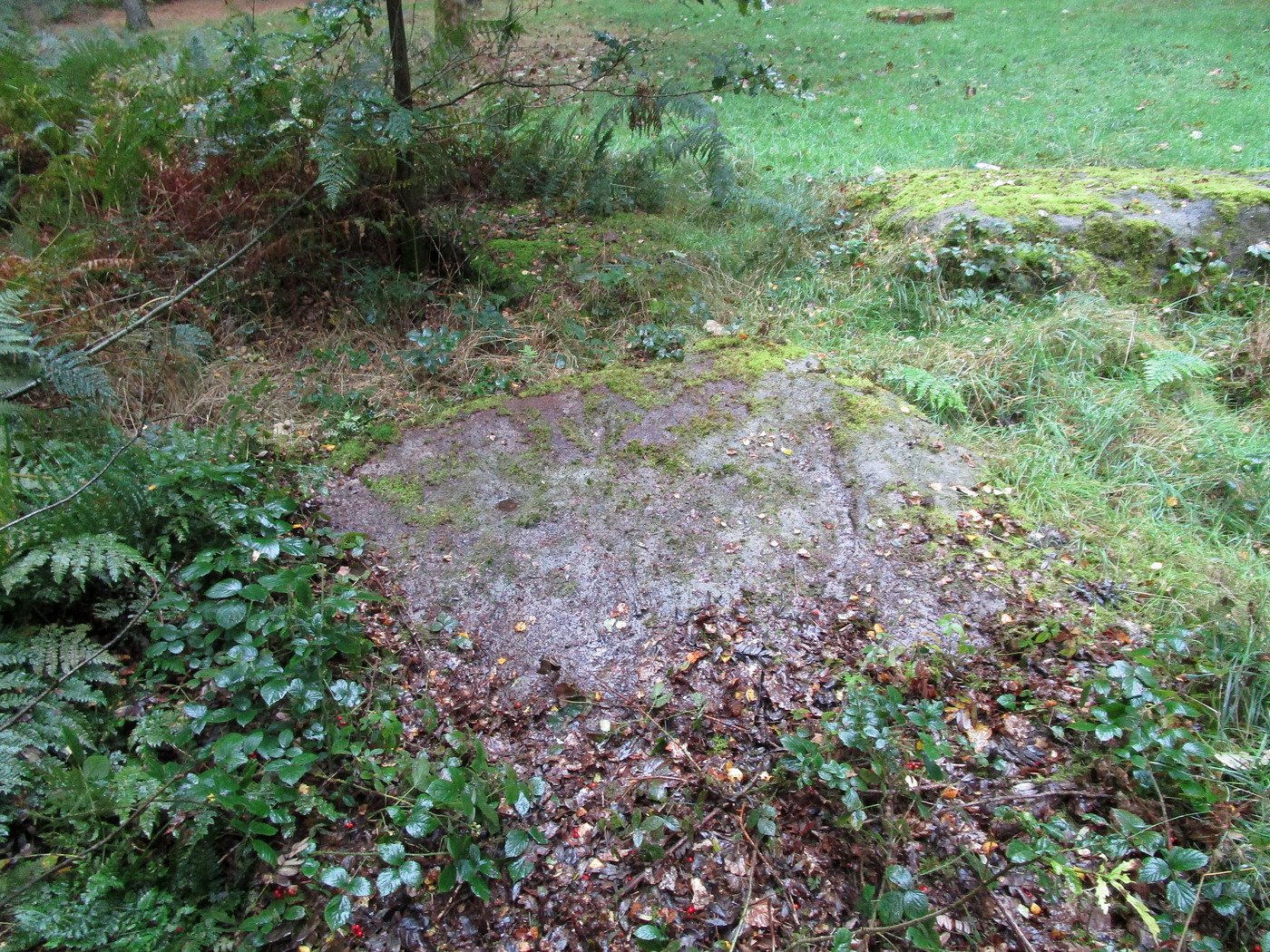
Follow the same directions as if you’re visiting the impressive Fairy Stone carving, then 3 yards east is the Cottingley 2 double cup-and-ring, keep walking past through trees for another 5-6 yards where you’ll come across this reasonably large curved flat stone. Y’ can’t really miss it
Archaeology & History
Cup, with ring faintly visible
This was another carving in the small cluster by the Fairy Stone that I found on my visit here in the 1980s—but it’s a pretty innocuous one to be honest. There’s a faded incomplete “ring” (not really visible on my photos due to pouring rain and very poor light when I was here) with a distinct cup-mark in the middle. Several inches away from the cup-and-ring is a carved line that arcs around it creating an incomplete oval design; and what seems to be a single cup-mark is visible at the top of this oval. Other marks on the stone are both natural as well as recent ‘scratches’.
Some elements of this carving—as with others in this petroglyph cluster—seems to be modern. The cup-and-ring seems to be the real deal, but the ‘oval’ seems to have been added much more recently, perhaps by the scouts who play around in this part of the woods.
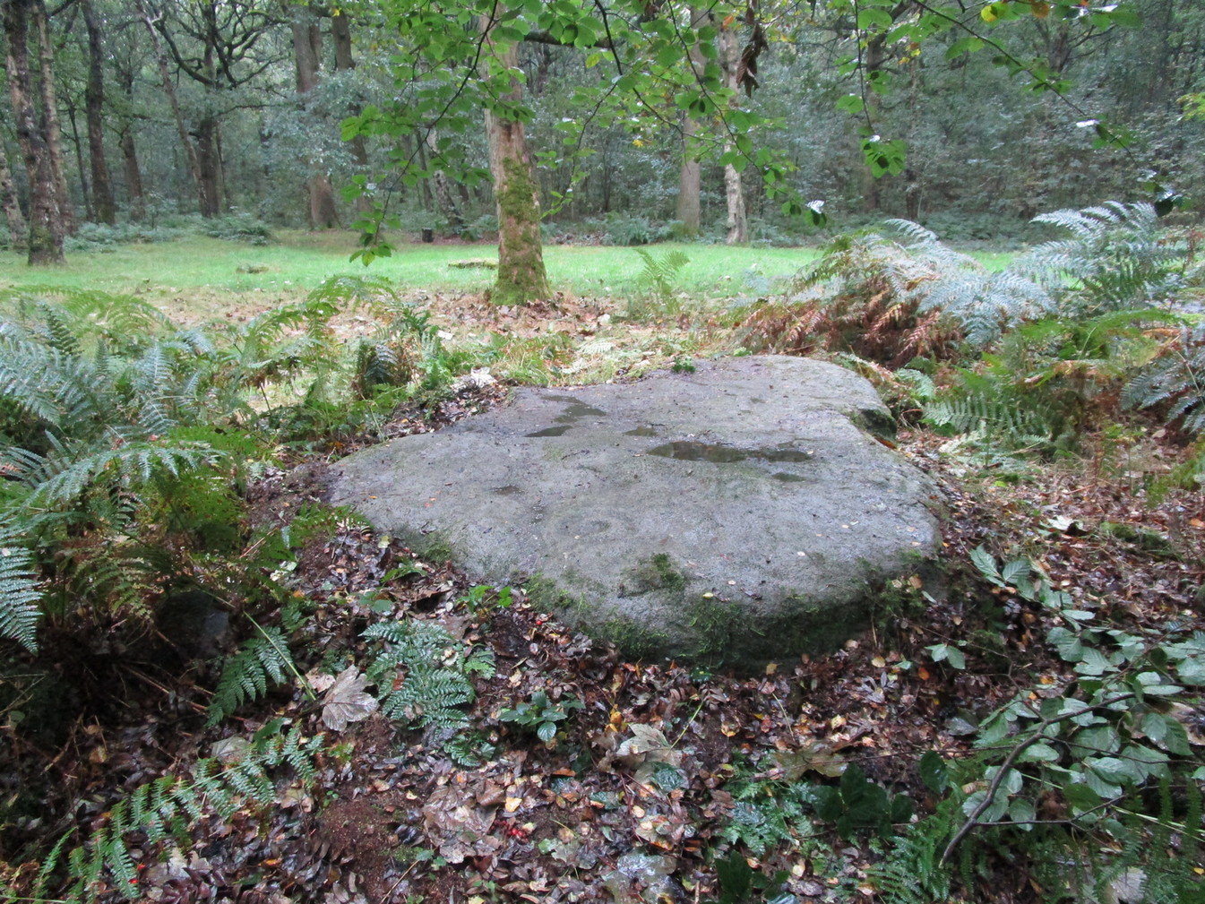
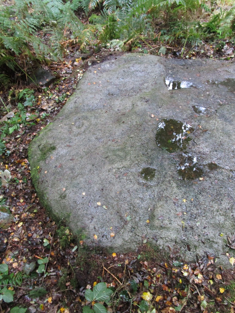
Get yerself to the Fairy Stone, then walk east past the adjacent woodland carvings—numbers 2, 3 and 4—from where you should walk about another 10 yards east across the grass, keeping your eyes peeled for a large flat stone measuring about 6ft by 10ft just as you go back into the tree cover north-side. You’ll find it.
Archaeology & History
This large carved rock is the easternmost known petroglyph in this small woodland cluster of five. (a sixth one can be found, but it’s several hundred yards east from here) Consisting of two distinct cup-and-rings in relative proximity to each other on the northern section of the stone, this design—unlike others in this group—has a greater sense of stylistic authenticity to it. Despite this, one of the two cup-and-rings seems to be a more recent addition to the rock, as close inspection shows peck marks that aren’t very well eroded as you’d expect on rock of this type if it was truly ancient. The more faded cup-and-ring on its northwestern section looks to have a greater sense of age about it when we look at its erosion level….perhaps…
The 2 Cup & RingsThe 2 cup-and-rings
We have to take into consideration when looking at this carving and the others nearby that possess some quite peculiar design-elements, that this section of woodland is used extensively by boy scouts who do what boy scouts do in their teenage ventures: from making fires, climbing trees and, perhaps, scribing on stones if/when their elders aint looking. It’s an important ingredient that has to be taken into consideration when looking at the more rash motifs hereby—this carving included. The more faded cup-and-ring on this, however, may be the real deal. And hopefully, next time I visit this site, She’ll not be dark and pouring with rain (much though I love such weather), so I’ll be able to get some better photos!
Follow the same directions as if you’re visiting the impressive Fairy Stone carving, then check out the overgrown rock three yards away, to the east. You might have to rummage under the scrubbage to see it, but you’ll find it if you want to!
Archaeology & History
I first found this stone in the 1980s when I’d been shown the Fairy Stone carving which, at the time, was thought to be all alone. But I used the olde adage: “where’s there’s one cup-and-ring, others tend to be“—and found this and several others closed by.
Large messy cup-and-ring
It’s a relatively small, slightly-domed earthfast rock, upon which we find an unusually large cup-and-double-ring design with a carved line running from the large central cup out to the edge of the stone. However, the carved lines that constitute both the inner and outer rings are ‘crude’ in form and style when compared to the vast majority of other British petroglyphs; and for some reason, this aspect of the design has me casting doubts over its prehistoric authenticity. I hope I’m wrong!
References:
Bennett, Paul, ‘Tales of Yorkshire Faeries,’ in Earth 9, 1988.
Bennett, Paul, The Old Stones of Elmet, Capall Bann: Milverton 2001.
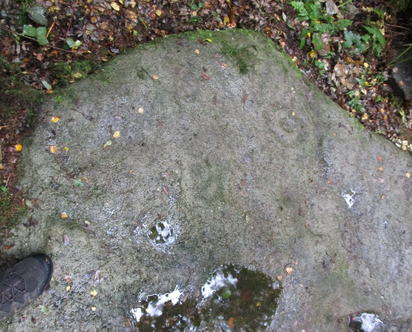
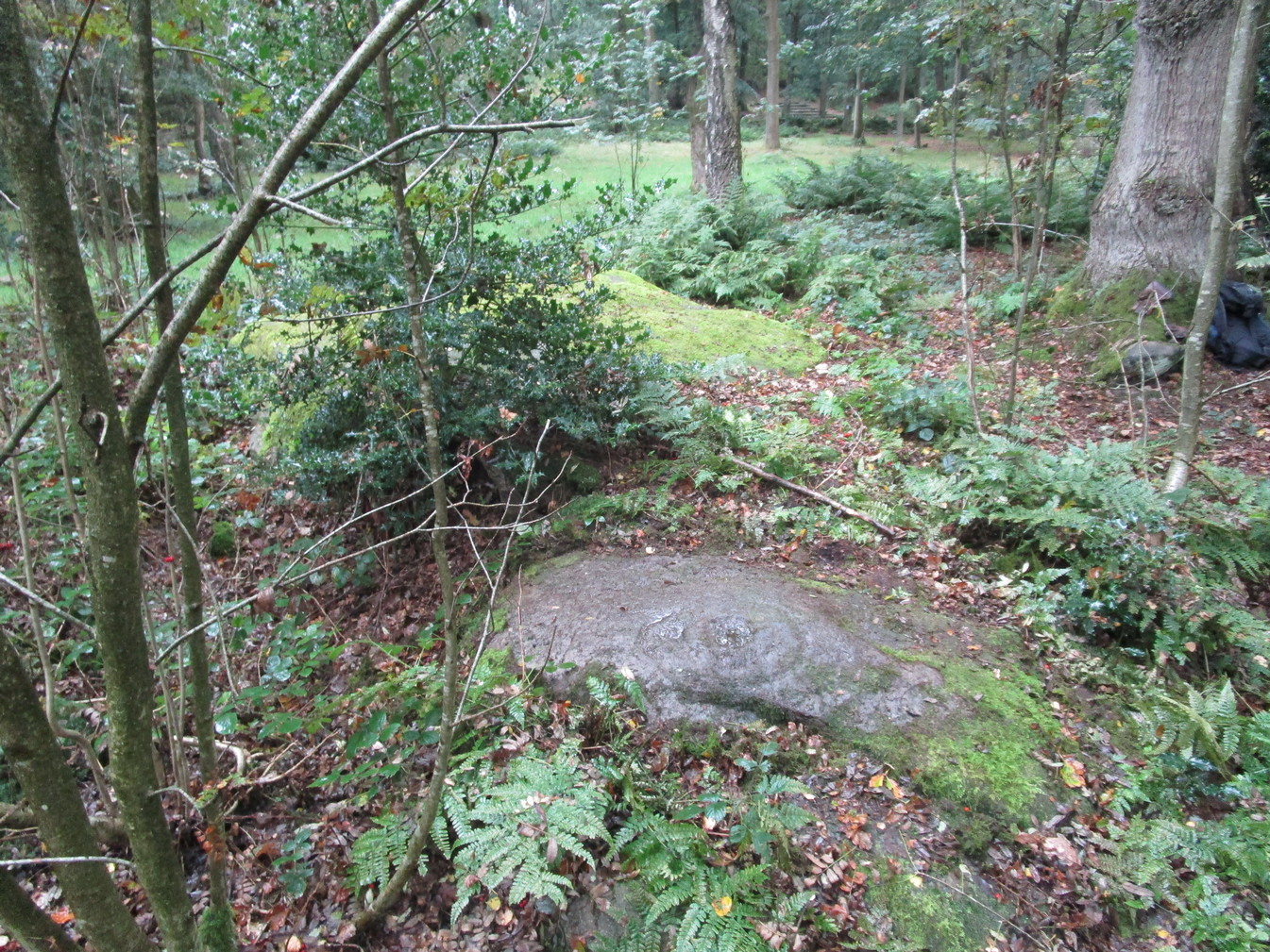
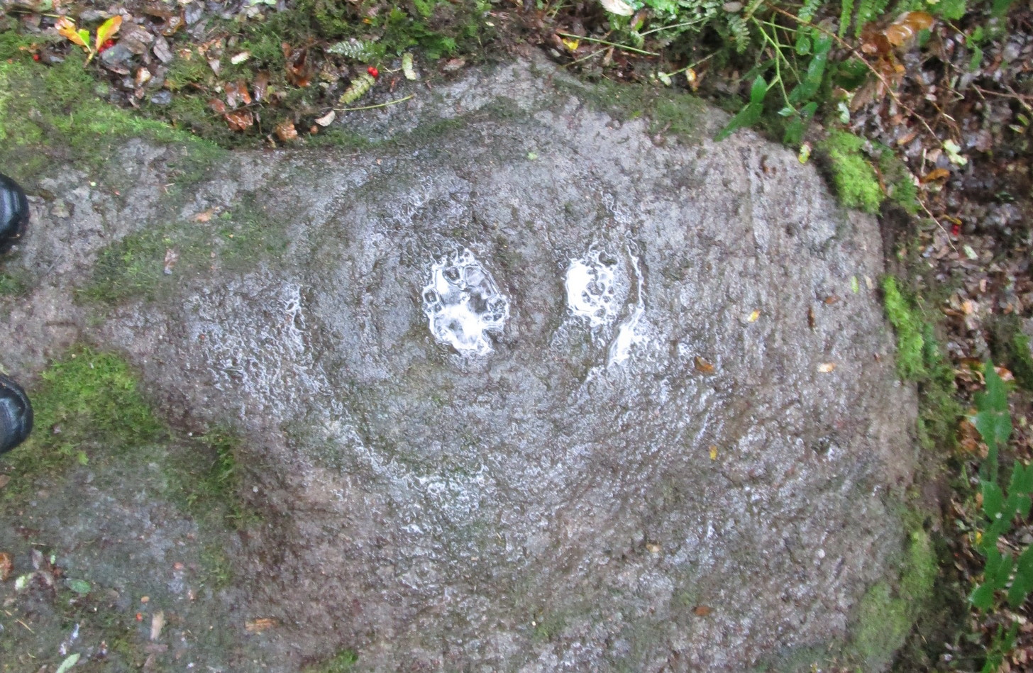
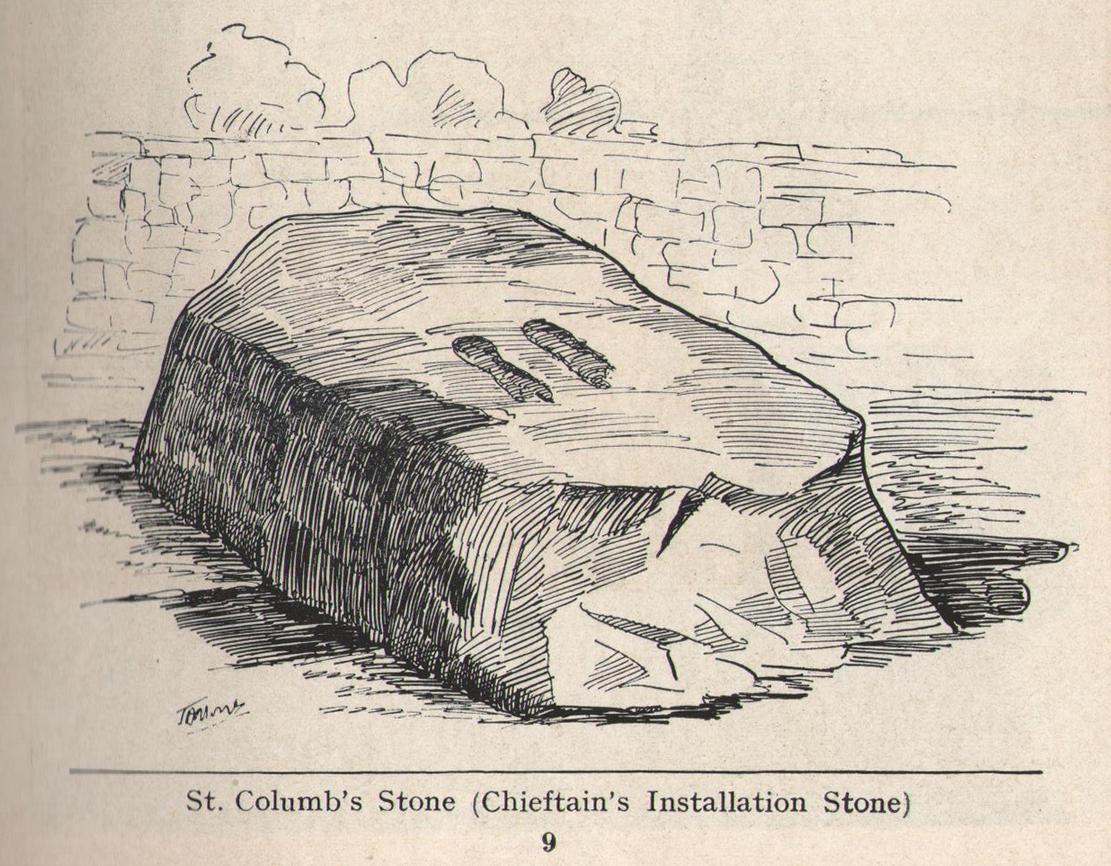
To be found in the grounds of Belmont House School, just 1¾ miles (2.8km) north of Derry’s otherColumba’s Stone, this is one of the many petroglyphic “footprints” that folklore ascribes to Ireland’s saint Columb/Columba/Columbkille (and other variants). Said to have originally been carved at the great fortress of Grianan of Aileach, 4½ miles (7.2km) to the west, this great block of stone—roughly 6 feet square on top—has the distinct sculpturings of two feet, each about 10 inches long, etched into its sloping surface. Archaeologically speaking, there’s little more to say about the stone; but its traditions are another thing altogether and are of considerably greater importance…
Folklore
Like the carved footprint on top of Dunadd in Argyll with its association of tribal initiations, the traditions relating to this footprint follows the same path, so to speak. It was H.P. Swan (1938) who gave us a good summary of the olde lore here, telling that,
“It is almost absolutely certain that it was brought from the Grianan of Aileach after its destruction, probably by an O’Doherty for his own installation. If so, the task of removal was no joke, for the stone weighs some seven tons. It was the “crowning stone” of the Kinel-Owen, or, in other words, the stone upon which the chieftains of the great O’Neill clan were inaugurated. They reigned in Aileach for many centuries.
“At his installation, as supreme head of the clan, the newly-chosen chief was placed upon this stone, his bare feet in the footmarks; a peeled willow wand was put into his hand, as an emblem of the pure and gentle sway he should exercise over his tribe; an oath was administered to him by the chief ecclesiastic in the neighbourhood, that he should preserve inviolable the ancient custom of his country, and deliver the succession peaceably to his tanist (successor); after which, descending from the stone, he turned himself thrice backwards and thrice forwards, to signify that he was ready to meet all foes, from whatever quarter they might come; and was then, with wild acclamations, hailed as their chief by his assembled clan.
“At the time of Ireland’s conversion to christianity by St Patrick, that holy man visited the Grianan (about AD 443), where this stone had been so used for centuries before; Owen was then King; he was converted from Paganism to the new faith and baptised by Patrick; at the same time, the saint consecrated this stone, and blessed it as the crowning-stone of the Kinel-Owen for ever. Time, however, has proved his blessing futile, as may be read in the account of the Grianan, which was deserted by the Kinel-Owen after its destruction by the O’Briens in 1101.”
The ritual described here cannot be taken lightly, nor seen as a presentation of fiction, for its ingredients are found echoed in kingship rites in many cultures.
References:
Swan, Harry Percival, The Book of Inishowen, William Doherty: Buncrana 1938.
St Columbkille’s place in Irish history was considerable and, said Maghtochair (1867), he was said to have “founded more than one hundred churches and religious houses.” His feet, also, have been carved or burned into a number of rocks scattering the Irish landscape. Not to be confused with his ‘feet’ that are carved near Londonderry, the ones here have been classed in the archaeological inventories as a bullaun and, wrote Brian Lacy (1983) in the Donegal Archaeological Survey, can be found on,
“A 2m long ledge of rock outcrop containing two depressions, c.0.33m in diameter x ).1m deep. They are known locally as St. Columbkille’s footprints.”
As can be seen in the above photo, the ‘footprints’ seem to have been artificially outlined at some time long ago, to make them more notable.
References:
Lacy, Brian, Archaeological Survey of County Donegal, Donegal County Council 1983. p.307
Maghtochair, Inishowen – Its History, Traditions and Antiquity, Journal Office: Londonderry 1867.
Sconce, James, “Cup-Marked Stones,” in Transactions of the Edinburgh Field Naturalists, volume 5, 1907.
Swan, Harry Percival, The Book of Inishowen, William Doherty: Buncrana 1938.
Acknowledgements: Big thanks to Catherine, of the We Love Donegal website.
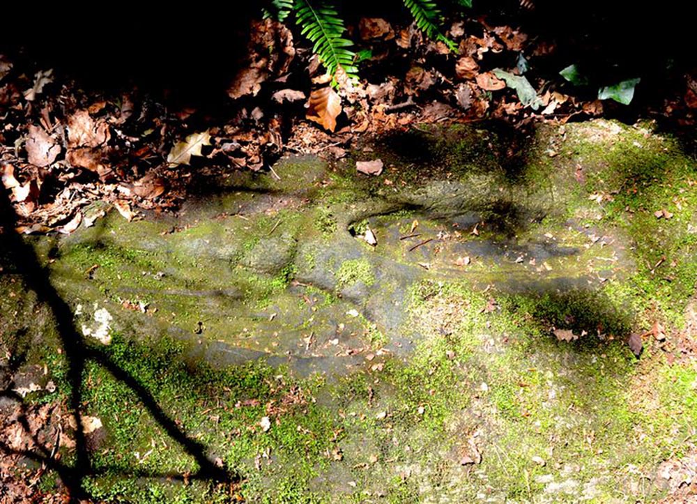
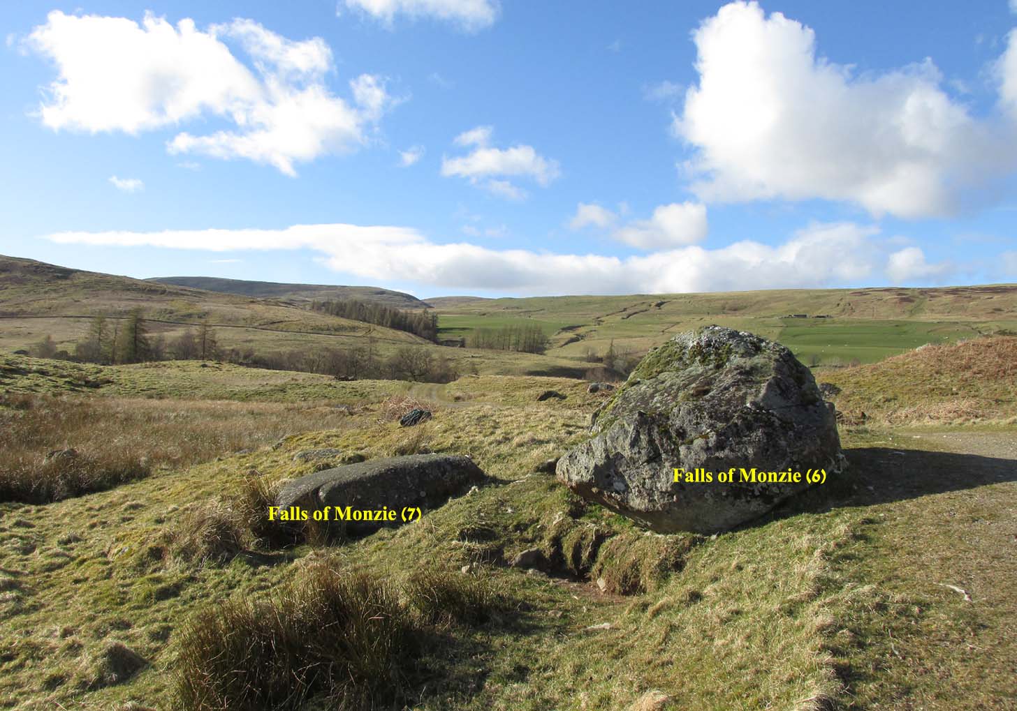
A couple of miles east of Crieff, take the A822 road from the Gilmerton junction towards the Sma’ Glen. After literally 1¾ miles (2.8km)—just 100 yards before the track up to Connachan Farm—you’ll reach a dirt-track on your left that leads into the hills. Go on here and after an easy walk of 400 yards or so, you’ll reach the conspicuous boulder known as the Falls of Monzie (6) stone. Two or three yards to its side is a large flat stone. That’s it!
Archaeology & History
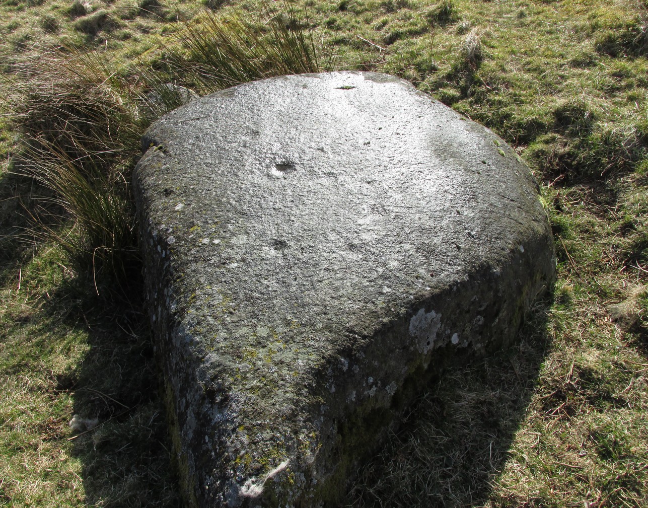
This large flat smooth earthfast rock, is possessed of a number of very faint cup-marks. Altogether there are at least nine cup-marks, most of which are closing in to the middle of the stone, with other single cups near the western and southern edges.
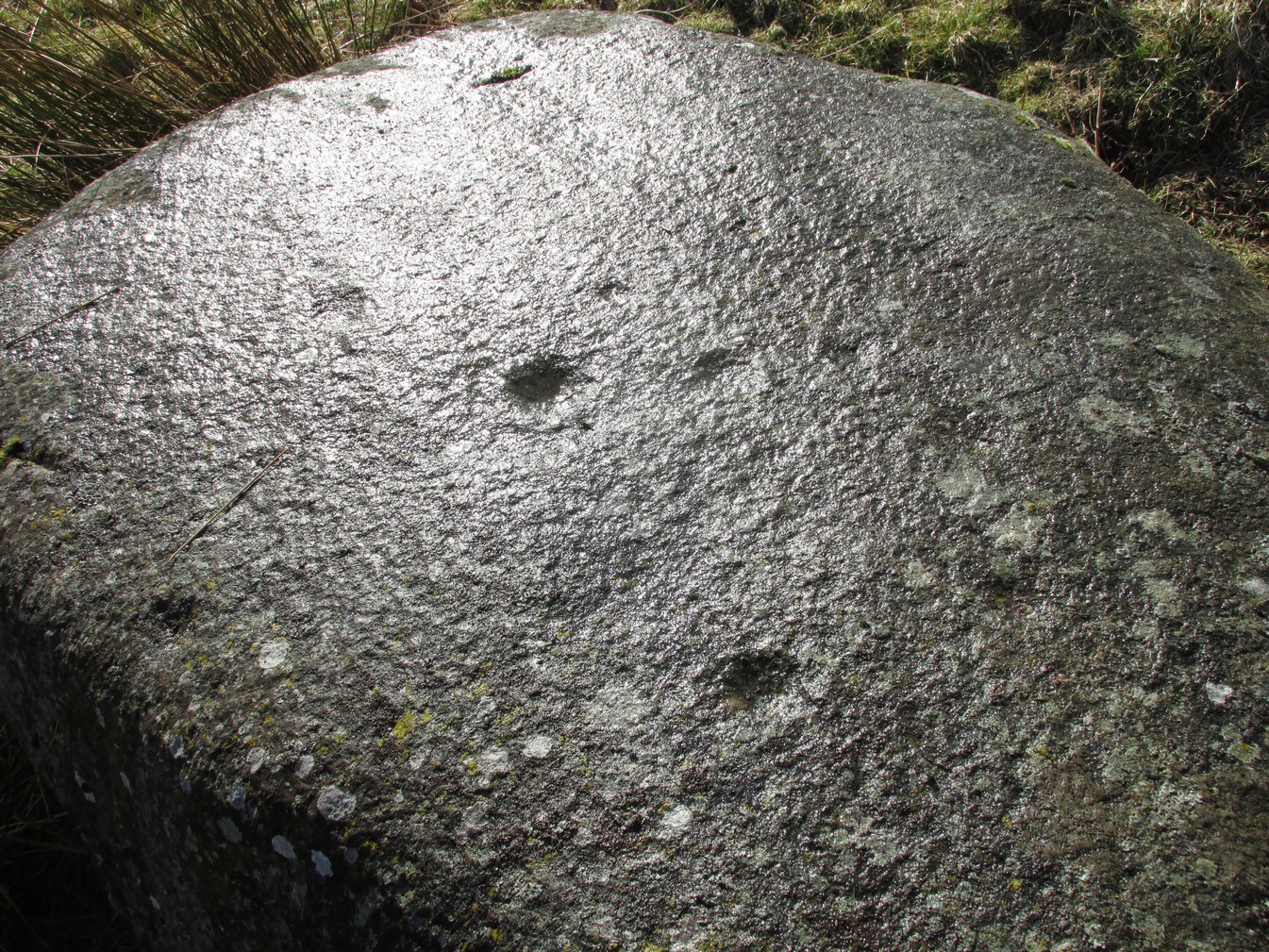
The faint cupmarksClose-up of cups
Near the middle of the rock, one cup has an equally faint semi-circular arc, just visible on the photos here. Close-up photos of this semi-circle seem to suggest it was more complete in ages gone by, but the erosion is such that it’s difficult to say with any certainty. (possibly the computer-tech kids could give us a bit more certainty). The nearest other carving with more definite cup-and-rings can be found on the Falls of Monzie (8) stone, about 200 yards to the west.
Follow the same directions as if you’re visiting the Wester Glentarken (1) carving, but some 10-15 yards before reaching it, you’ll notice this smaller rock with a series of curious naturally-eroded features on it.
Archaeology & History
This rounded stone has a series of natural deep cracks and undulating geological features on its surface, some of which look like elongated man-made cup-marks—but they’re not! The only man-made ingredient on this stone is the deep single cup-mark close to the centre of the stone, as you can see in the photo. That’s it—nowt else!
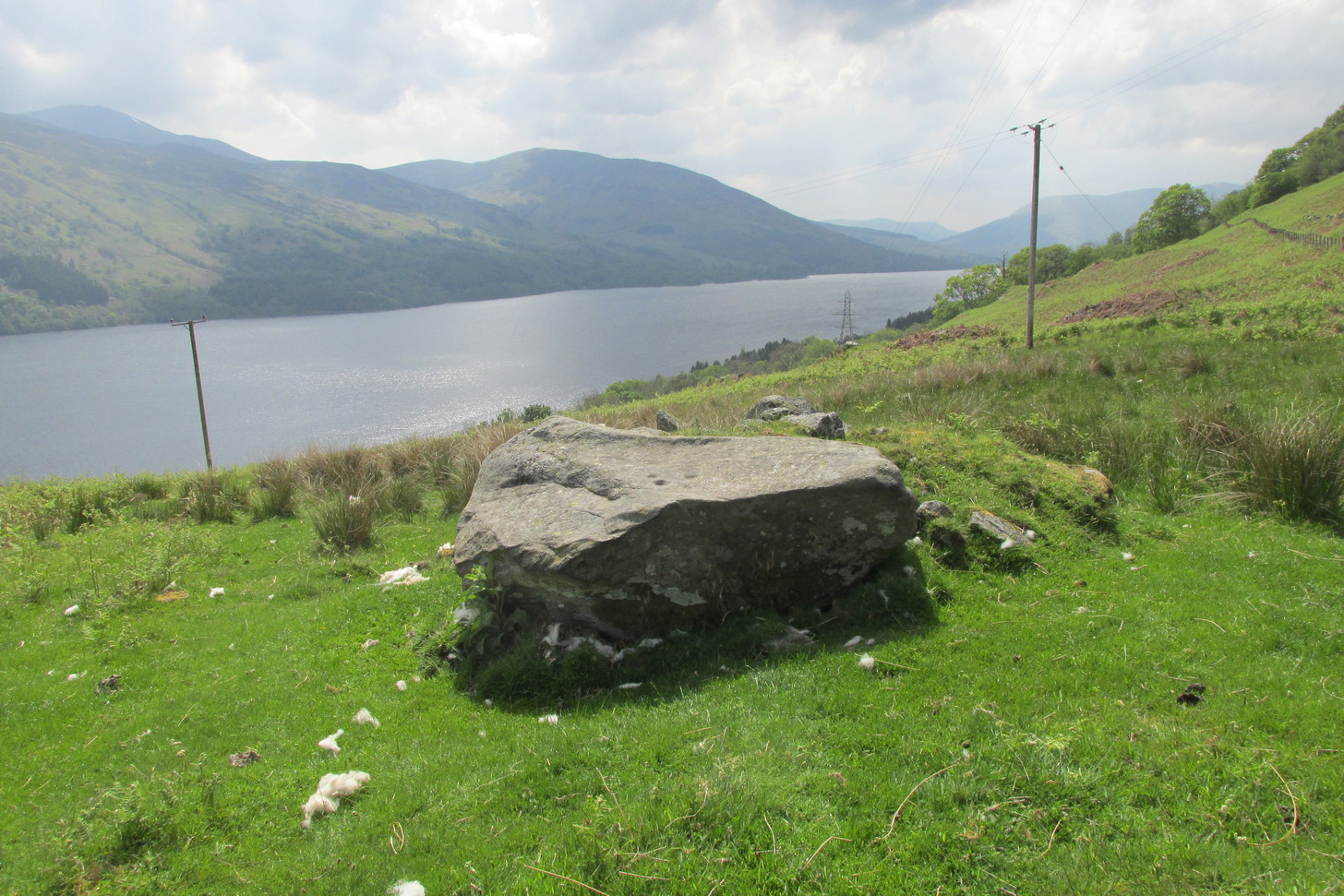
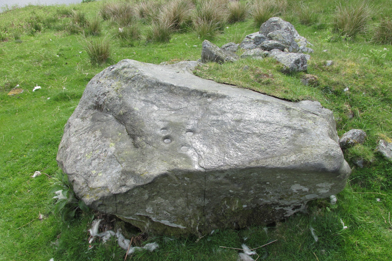
1½ miles out of St Fillans on the A85 road to Lochearnhead you’ll reach the boating marina by the lochside. A hundred yards or so past this, park up. Cross the road and walk 50 yards to your right then follow the dirt-track up into the trees. After ⅓-Mile (0.5km) turn left to the old house on your left and follow the green path around it, then around the right-side of the rocky knoll in front of you. Once you’re on the level ground around the knoll, walk forward for less than 100 yards. Y’ can’t really miss it!
Archaeology & History
4 of the 5 main cups
A simple design, but a clear one, of four deep cup-marks which can be seen on the eastern side of the stone, with a solitary one—much more faint—just over the rise on the more western section of the rock.
There are a number of other large sections of rock around the knoll with what appear to be cup-markings of various forms, but apart from perhaps one or two exceptions, the vast majority of them—as Currie (2005) also noted—seem to be natural.
References:
Currie, George, “Wester Glentarken, Perth and Kinross (Comrie parish), cup-marked rocks,” in Discovery & Excavation Scotland, vol. 6, 2005.