From the Askwith Moor car-park, walk down the road (south) for 2-300 yards until you reach the gate on the right-hand side of the road. Go thru this and turn immediately left, following the fence along, parallel to the road for about 100 yards (if you reach the small disused quarry, you’ve gone 100 yards too far), then walk into the heath, up near the top of the little peak and walk down the other side of the slope for about 80 yards. You’re getting damn close — look around!
Archaeology & History
First found on the afternoon of May 13, 2010, in the company of Dave Hazell — though at the time the light was poor and the sky was grey and overcast, not allowing for any decent images being made. We returned here yesterday under a lovely clear sky for most of the day (and without the polluting roars of planes from the nearby airport, thanks to that great Icelandic volcano [keep it going!], making it even better) and got some decent photos this time.
Sketch of basic designClose-up of some cups
It’s only a small low stone, slightly sloping (similar in size and form to carving no.535 about 100 yards west of here), and is gonna be very difficult to find when the heather is in full growth. But thankfully when we found it last week, the heather had been burnt back. Whilst there are two large and very notable cups here — one on the west-facing vertical edge of the stone, the other on its south-facing slope — several others are more troublesome to see clearly, both through a mixture of age and erosion. The other cups are a little smaller aswell, being very similar in status to the curious small cup-markings on the Lattice Stone carving (no.481). One cluster of these smaller cups are arranged in a curved T-shape formation around the middle to eastern-side of the rock. Below this are what seems to be a long singular cup, but upon feeling this — the Beckensall technique — the hardworking Keighley volunteer Michala Potts found it seemed to consist of three small cups all linked to each other. Attached to this section, a small groove runs up to the aforementioned T-formation cluster. Whilst at the top-end of the stone is what seems to be another larger cup-marking, but I’m not sure whether it’s Nature’s handiwork, or artificial. A few more visits here might enable us to say one way or the other!
There are no other archaeological remains immediately adjacent. Another “possible” cup-marked rock (more than twice the size of this stone) can be found about 30 yards further uphill, next to another large stone. But one of the nice things about this small carving is its position in the landscape: an excellent view opens up of mid-Wharfedale below you, and the uphills of Rombald’s Moor is on the far side of the valley. Make of it what you will…
References:
Boughey, Keith & Vickerman, E.A., Prehistoric Rock Art of the West Riding, WYAS 2003.
To get here, follow the same directions to reach the ornate Lunar Stone. Once here, walk about 20 yards west towards where the brow of the hill begins to slope down. Amble about and you’ll easily find it.
Archaeology & History
This is a fascinating carving. Fascinating, inasmuch as it seemingly keeps changing appearance when Nature moves her daylight hues and whimsical unpredictability betwixt the hills, surrounding landscape and human observer. Depending very much where you stand and when you look at this small rock — dappled with unacknowledged veils of sunlights, grey winds and other natural forces — determines what the stone shows you. This carving as much as any upon this hill shows once again the hugely neglected dynamic between human purveyor and Nature’s powerful subtlety: an organic exchange of moods from stone to man and back again; very much how our ancestors saw things to be…
Pecked lines clearly visible on the far end of the rockCarving from above
For if we were to merely pay attention to what the reference books tell us about this carving (good reference books though they are!), we’d simply be seeing a rock possessing a “cup and partial ring and two other possible cups”, as Boughey & Vickerman (2003) and other students might do. But then, if conditions change, only subtly, and we gaze instead of study, other things can emerge. And just such a thing happened when we came here yesterday…
On my first visit here I could only see a single cup-marking, with another ‘debatable’ close by. The light of day wasn’t quite right it seemed. But when we visited here yesterday, the sun, the light, the land and our ambling minds saw much more unveiled from this old grey surface. Whilst two cups-and-rings seem to link with another cup on the lower end of the stone, amidst the natural cracks and fissures, on the higher end are very distinct carved pecked lines, one of which has been blatantly cut onto, or upon, the long curving crack which runs from one end of the stone to the other. As this carved line emerges out of the natural crack, it heads upwards. As it does so, another line has been pecked running off it to the left and then curves back down the sloping rock-face once again. But in this previously unrecognised carved section, these lines may extend even further up the rock…..it’s hard to say for sure. We could do with greater analysis of its surface, with further observations under yet more lighting conditions.
References:
Boughey, Keith & Vickerman, E.A., Prehistoric Rock Art of the West Riding, WYAS 2003.
Hedges, John (ed.), The Carved Rocks on Rombalds Moor, WYMCC: Wakefield 1986.
Difficult to locate when the heather’s deep, but, from the Askwith Moor Road car-parking spot, walk up the road till you hit the fencing that cuts across Snowden Moor on your right. Follow the fence across the moor for about 300 yards where the moorland slope increases downhill. Go down here, keeping to the northern side of the fence and zigzag about. Good luck!
Archaeology & History
Cup-marked stone, Snowden Carr
On the hillside west of the Snowden Moor Settlement is this previously unrecorded cup-marked stone, discovered by Richard Stroud in May 2005. From the photo you get the impression there are perhaps 10 cup-markings etched onto the stone here, but looking at the site in the cold light of day, we both reckoned that perhaps just two or three of them were man-made. This is one of them carvings which has you scratching your head about the problems with some “carvings” and the difficulty one can sometimes have when it comes to answering the simple query about whether they’re natural or man-made.
It’s worth a look this one — not least because, when the conditions are right and the heather’s been burnt back, there’s one helluva decent prehistoric settlement very close by, giving you even more to puzzle over…
From the large parking spot by the roadside along Askwith Moor Road, walk up (north) 250 yards until you reach the gate with the path leading onto Askwith Moor. Follow this along, past the triangulation pillar until you reach the Warden’s Hut near the top of the ridge and overlooking the moors ahead. Naathen — look due south onto the moor and walk straight down the slope till the land levels out. If you’re lucky and the heather aint fully grown, you’ll see a cluster of stones about 500 yards away. That’s where you’re heading. If you end up reaching the Woman Stone carving, you’ve walked 100 yards past where you should be!
Archaeology & History
Discovered on the afternoon of May 13, 2010, amidst another exploratory ramble in the company of Dave Hazell. We were out looking for the Woman Stone carving and a few others on Askwith Moor, and hoping we might be lucky and come across another carving or two in our meanderings. We did find a previously unrecorded cup-marked stone (I’ll add that a bit later) — and a decent one at that! — but a new cairn-field was one helluva surprise. And in very good nick!
Cairn A, looking northwestCairn A, looking east
There are several cairns sitting just above the brow of the hill, looking into the western moors. Most of these are typical-looking single cairns, akin to those found on the moors above Ilkley, Bingley and Earby, being about 3 yards across and a couple of feet high amidst the peat and heather covering. But two of them here are notably different in structure and size (and please forgive my lengthy description of them here).
We found these tombs after noticing a large section of deep heather had been burnt back, and a large mass of rocks were made visible as a result. Past ventures onto these moors when seeking for cup-and-ring carvings hadn’t highlighted this cluster, so we thought it might be a good idea to check them out! As I approached them from the south from the Woman Stone carving (where we’d sat for a drink and some food, admiring the moors and being shouted at by a large gathering of geese who did not want us here), it became obvious, the closer I got, that something decidedly man-made was in evidence here.
Cairn A, looking south
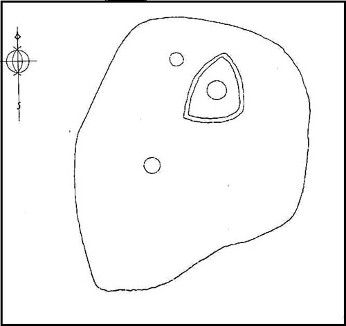
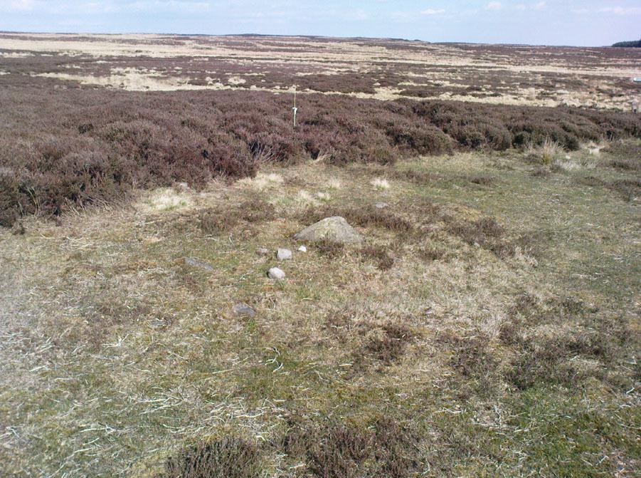
Walking roughly northwards out of the heather and onto the burnt ground, a cairn-like feature (hereafter known as “Cairn A”) was right in front of me; though this seemed to have a ring of small stones — some earthfast, others placed there by people — surrounding the stone heap. And, as I walked around the edge of this large-ish cairn (about 9 yards in diameter and 2-3 feet tall), it was obvious that a couple of these outlying stones were stuck there by humans in bygone millenia. The most notable feature was the outlying northernmost upright: a small standing stone, coloured white and distinctly brighter than the common millstone grit rock from which this monument is primarily comprised. As I walked round it — adrenaline running and effing expletives emerging the more I saw — it became obvious that this outlying northern stone had long lines of thick quartz (or some crystalline vein) running across it, making it shine very brightly in the sunlight. Other brighter stones were around the edge of the cairn. It seemed obvious that this shining stone was of some importance to the folks who stuck it here. And this was confirmed when I ambled into another prehistoric tomb about 50 yards north, at “Cairn B.”
Cairn B, looking northCairn B, looking east
Cairn B was 11 yards in diameter, north-south, and 10 yards east-west. At its tallest height of only 2-3 feet, it was larger than cairn A. This reasonably well-preserved tomb had a very distinct outlying “wall” running around the edges of the stone heap, along the edge of the hillside and around onto the flat moorland. Here we found there were many more stones piled up in the centre of the tomb, but again, on its northern edge, was the tallest of the surrounding upright stones, white in colour (with perhaps a very worn cup-marking on top – but this is debatable…), erected here for some obviously important reason which remains, as yet, unknown to us. Although looking through the centre of the cairn and onto the white upright stone, aligning northwest on the distant skyline behind it, just peeping through a dip, seems to be the great rocky outcrop of Simon’s Seat and its companion the Lord’s Seat: very important ritual sites in pre-christian days in this part of the world. Near the centre of this cairn was another distinctly coloured rock, as you can see in the photo, almost yellow! Intriguing…
The smaller “Cairn C”
Within a hundred yards or so scattered on the same moorland plain we found other tombs: Cairns C, D, E, F, G and H — but cairns A and B were distinctly the most impressive. An outlying single cairn, C, typical of those found on Ilkley Moor, Bingley Moor, Bleara Moor, etc, was just five yards southwest of Cairn A, with a possible single cup-marked stone laying on the ground by its side.
Just to make sure that what we’d come across up here hadn’t already been catalogued, I contacted Gail Falkingham, Historic Environment team leader and North Yorkshire archaeological consultant, asking if they knew owt about these tombs. Gail helpfully passed on information relating to a couple of “clearance cairns” (as they’re called) — monument numbers MNY22161 and MNY 22162 — which are scattered at the bottom of the slope below here. We’d come across these on the same day and recognised them as 16th-19th century remains. The cairnfield on top of the slope is of a completely different character and from a much earlier historical period.
We know that human beings have been on these moors since mesolithic times from the excess of flints, blades and scrapers found here. Very near to these newly-discovered tombs, Mr Cowling (1946) told that:
“On the western slope of the highest part of Askwith Moor is a very interesting flaking site. For some time flints have been found in this area, but denudation revealed the working place about August, 1935. There were found some twenty finished tools of widely different varieties of flint. A large scraper of red flint is beautifully worked and has a fine glaze, as has a steep-edged side-blow scraper of brown flint. A small round scraper of dull grey flint has the appearance of newly-worked flint, and has been protected by being embedded in the peat…One blade of grey flint has been worked along both edges to for an oblong tool… The flint-worker on this site appears to have combed the neighbourhood to supplement the small supply of good flint.”
All around here we found extensive remains of other prehistoric remains: hut circles, walling, cup-and-ring stones, more cairns, even a probable prehistoric trackway. More recently on another Northern Antiquarian outing, we discovered another previously unrecognised cairnfield on Blubberhouse Moor, two miles northwest of here.
References:
Cowling, Eric T., Rombald’s Way: A Prehistory of Mid-Wharfedale, William Walker: Otley 1946.
Jack, Jim, “Ancient Burial Ground and Bronze Age Finds on Moor,” in Wharfedale Observer, Thursday, May 27, 2010.
From Shipley Glen, walk up to the Dobrudden caravan park on the western side pof Baildon Hill and then in the long grasses immediately north of here, on the Low Plain, this old carving could once be found. I’m told it’s been moved in recent years (but have a mooch round anyway – there’s a number of other old cup-and-rings in the locale).
Archaeology & History
This small carving is not in its original position, having been moved to where it now sits a short distance northeast of the Dobrudden caravan park. It was first described briefly in Mr Baildon’s magnum opus here, seemingly omitted from the Hedges (1986) and reclassified as ‘stone 169’ by Boughey & Vickerman (2003). I’m not 100% certain that the illustration here by Joseph Rycroft and carving no.169 are one and the same – but they seem incredibly alike. If anyone knows for sure, one way or the other, please lemme know and I’ll amend as necessary!
References:
Baildon, W. Paley, Baildon and the Baildons – part 7, Adelphi Press: London 1913.
Boughey, Keith & Vickerman, E.A., Prehistoric Rock Art of the West Riding, WYAS 2003.
Hedges, John (ed.), The Carved Rocks on Rombalds Moor, WYMCC: Wakefield 1986.
From Earby, go eastwards up the steep moorland Coolham Lane. A coupla hundred yards up past the little reservoirs on your right there’s a tall, large wooden stile to climb over, up the old heaps of quarried stone and onto the flat moorland plain of Bleara Moor. You’re here! If the heather’s grown back however, you’ve no chance of seeing ’em!
Archaeology & History
One of at least a dozen small cairns on NW of Bleara Moor
When we came up here the other day (ostensibly to check out the great Bleara Lowe tombs on top of the moor), a grey wet day scattered its more darkened light across the moor, which thankfully had been burnt back a few months previous. If this hadn’t happened, we’d have never seen what we found: a scattering of at least a dozen small single cairns, typical of those found on the upper and lower slopes of Green Crag Slack on Ilkley Moor. They’re on the lower northwest-facing plain of Bleara Moor and all are roughly the same size: about 3 yards by 3 yards across and only a foot or two in height, much overgrown in peat and vegetation. Although we found a good number of these small cairns where the heather had been burnt away, there also seemed to be others in the long heather itself, but this was, of course, hard to say with any certainty. A few more exploratory ventures in and around the moor would be good after the next heather-burning sessions!
From East Morton village, take the moorland road, east, and up the steep hill. Where the road levels out there’s a right turn, plus (more importantly!) a trackway on your left which leads onto the moor. Go up this track for a few hundred yards until you’re on the moor proper (by this I mean the track’s levelled out and you’re looking 360° all round you with all the moor in front of you). Just before the track starts a slight downhill slope, go into the heather on your right, for about 80 yards. You’re damn close!
Archaeology & History
I first came here many years back in my mid- to late-teens with an old school-friend Jon Tilleard, wandering about adventurously, occasionally stopping here and there when I found some stupid cup-mark or other seemingly innocuous scratch on the rocks, gerrin’ all excited and jumping about like a tit! But when we visited the place again a few days back my response was somewhat different. I was worse! But for good reason…
Primary features of CR-107Close-up of main features
The potential variations visible in this carving are peculiar, to say the least. Ones first impression shows a carving similar in many ways to that shown in Hedges (1986) fine survey; but upon closer inspection a number of initial visual responses begin to look murky. A seeming cup-with-double-ring aint what it seems! To me at least (sad fella that I am!), it’s far more intriguing and far less certain, with a number of oddities still left.
The central feature of the carving is the lovely near-cup-and-double-ring! As we can see in the photo here, there are some insecurities in the top-right of the outer ring. To the upper right of this is another cup-with-partial-ring that was not included in the Hedges (1986) survey, nor Boughey & Vickerman’s (2003) updated work. There are some obvious pecked carved lines — whose specific definition yet remains unclear — in and around this area of the petroglyph; but in the “official” illustration these elements or ingredients were somehow missed.
Eclipse Stone, looking west
When we visited the stone the other day, the naturally eroded lines on the rock seemed pretty obvious; but the more we looked, the less secure we were about some of them. Thankfully the light kept changing about, allowing us to get different perspectives — and with the low sunlight of evening casting itself across the rock, some additional features seemed obvious. In particular, what seemed like two natural “scratches” on the stone turned out to have been pecked and carved and the straight lines ran into the double cup-and-ring on the left-side. One of these — the lower and shorter of the two — seems to run into the central cup, but this aint certain. The longer top line has an even more circuitous venture: entering the outer ring, it passes onto the top-inner ring and then bends along its edge, before exiting again on the right-hand side, through the outer ring and heading out towards the large natural eroded cutting a few feet away (see my crappy drawing to get an idea). Other faint aspects on this stone may have the hand of man behind them…
My shit sketch!Hedges 1986 sketch
There are certainly a few other cups on the stone: one with a near semi-circle on its lower and right-hand side. The long nature-worn cut, right-of-middle, may have had the hand of man cutting into the cup at the bottom; and another couple of “is it? — isn’t it?” enhanced natural cups seem possible on the left side of the rock. There is also what looks like a distinct single cup-marking on the west-facing vertical face of the stone (you walk towards it from the track). It looks pretty decent, but I’ll let them there “professionals” assess the validity or otherwise of that one! But the other unmistakable and very curious ingredient is the deep, worn arc beneath the primary double-ring feature. This is, as the photo shows, separated by a long natural crack running halfway down and along the stone, above which possibly the double-ring feature touches. This large ‘arc’ feature gives the distinct impression of being a big smile! However…
Turn the image of the central feature upside down and you get a very different effect indeed. A rainbow above the surface of the Earth, with (perhaps) a pool in which the sun has reflected? Or an underworld venture? Looking at it from a few angles gives the impression of a comet moving across the sky, aswell as an eclipse with the diamond-ring effect. But as with cup-and-ring in general, there are plenty of other potentials! Which also begs the question: was it to be looked from the top or bottom (or left or right for that matter)?
I could waffle about this particular carving for much longer, showing that it had quite an effect on me. Check it out and sit with it for a while… It’s superb!
References:
Boughey, Keith & Vickerman, E.A., Prehistoric Rock Art of the West Riding, WYAS 2003.
Hedges, John (ed.), The Carved Rocks on Rombalds Moor, WYMCC: Wakefield 1986.
From East Morton village, take the moorland road, east, and up the steep hill. Where the road levels out there’s a right turn, plus (more importantly!) a trackway on your left which leads onto the moor. Go up this track and keep walking till you hit a moorland ‘footpath’ signpost. Just before this walk due west (your left) into the heather for about 10 yards. Look around! (if the heather’s long and overgrown, you might have trouble finding it) If you find carved stone 109, you’re less than 10 yards off this one!
Archaeology & History
First reported by Stuart Feather and described in a short note of the Yorkshire Archaeological Register* of 1977. This was one of two small carved stones next to each other amidst the “denuded remains of a cairn 3m in diameter and 0.35m high.” The stone we can still see here is a small one, seemingly near the very centre of the cairn, with its carved face looking northwards. The carving is a simple double-ring surrounding a central cup: an almost archetypal cup-and-ring stone.
Crap photo of the double-ring
The other ancient carved stone that was once seen next to this (catalogued as carving 111) has in recent years been stolen by an archaeological thief no less! Any information that anyone might have telling us who’s stolen this heritage piece, or where it might presently reside, can be emailed to me in confidence. Or…the thief who’s taken it can return the carving to the site and put it back where it belongs before we find out where you live. Simple as!
(Soz about the poor photo of this carving. For decent ones of this stone you need to get here when the sun’s in a better position. I’ll hopefully get some better images next time we’re up there when the light’s better.)
References:
Boughey, Keith & Vickerman, E.A., Prehistoric Rock Art of the West Riding, WYAS 2003.
Hedges, John (ed.), The Carved Rocks on Rombalds Moor, WYMCC: Wakefield 1986.
Moorhouse, S. (ed.), “Yorkshire Archaeological Register: 1977,” in Yorkshire Archaeology Journal, volume 50, 1978.
* Does anyone have any idea who you report such new discoveries to so that they can be reported in Yorkshire Archaeology Society’s ‘Register’? I’ve asked ‘em several times about a number of previously unrecorded sites that we’ve located, so that they can make a record of them, but I never get a reply.
Takes a bitta finding this one. From the Twin Towers at the top of the moors (Whetstone Gate), walk east along the footpath, past the towers for about another 100 yards, looking out on the other side of the wall until you meet with some walling running downhill onto Morton Moor. Follow this walling for a few hundred yards till it drops down a small valley; then follow the valley down, keeping to its left-hand side, swerving a little round Black Knoll above you. Cross the dried-up stream and about 100 yards ahead of you (southeast), heading towards the Sweet Well, zigzag about (once the heather’s grown back here, this’ll take some finding!). Good luck!
Archaeology & History
Cup-markings, looking north
There’s no previous history to this site and archaeological records indicate no prehistoric remains in this region. However, we (that is Dave, Mikki and me) found this and a number of other sites yesterday in a bimbling wander, to and fro, through boggy-heaths and deep heather. It’s a previously unrecorded cup-marked stone, with what seems like an attached burial cairn right by its side (yet again!). The cairn is 3 yards by 2 yards across. Two very distinct cup-marks can clearly be seen near the top of the small stone, with a possible third just below. A curious though natural yoni-like erosion can be seen on the lower side of the stone which may have some significance to people into that sorta thing! Whether it had owt to do with the cup-markings is another thing altogether!
From East Morton village, take the moorland road, east, and up the steep hill. Where the road levels out there’s a right turn, plus (more importantly!) a trackway on your left which leads onto the moor. Go up this track and keep walking till you hit a moorland ‘footpath’ signpost. Just before this walk due west (your left) into the heather for about 10 yards. Look around! (if the heather’s long and overgrown, you might have trouble finding it)
Archaeology & History
Thought to be one of several carvings that were first reported by Stuart Feather and described in the Yorkshire Archaeological Register* of 1977: near the “denuded remains of a cairn” (there are in fact two here) is “a further cup-marked rock adjacent.” This is thought to be the one registered in John Hedges’ (1986) survey as ‘stone 91’. It’s a cute little thing, about 10 yards south of carving 110 (itself sited near the centre of a much-denuded burial cairn).
Carving 109, when wet!and when dry!
Similar in design to some of the Baildon Moor cup-marked stones (see carving no.126), the primary design here is a simple one: five cup-markings run along the edge of the small stone, with a small carved “line” running between two of the cups, as if denoting separation; whilst on the lower middle part of the stone is another, single cup, a little more worn than the others. It seems likely that this carving, like its double-ringed companion a few yards away (and others on this part of the moors) was in some way associated with the nearby prehistoric cairns.
References:
Boughey, Keith & Vickerman, E.A., Prehistoric Rock Art of the West Riding, WYAS 2003.
Hedges, John (ed.), The Carved Rocks on Rombalds Moor, WYMCC: Wakefield 1986.
Moorhouse, S. (ed.), “Yorkshire Archaeological Register: 1977,” in Yorkshire Archaeology Journal, volume 50, 1978.
* Does anyone have any idea who you report such new discoveries to so that they can be reported in Yorkshire Archaeology Society’s ‘Register’? I’ve asked ’em several times about a number of previously unrecorded sites that we’ve located, so that they can make a record of them, but I never get a reply.