Take the B936 out of Auchtermuchty, and park at the small car park for Auchtermuchty Common on your right just before Lumquhat Mill. Follow the path through the Common southwards and along the narrow strip until the Common opens out past the boundary stone. Head for the sign board on the right and when you get there turn left and march straight up the hillock and the stone is ahead of you in front of a gorse bush.
Archaeology & History
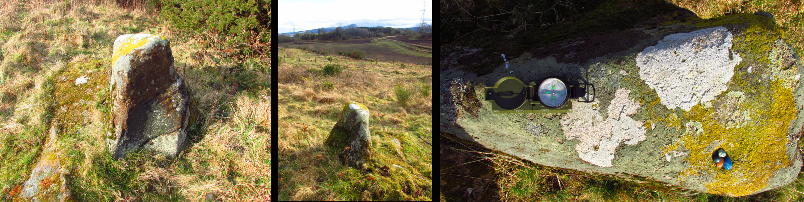
A curious little stone that I found quite by chance. It is wedge shaped in plan, bearing one large cup mark on its top surface. The cup is approximately 2″ in diameter and about ¾” deep. The raised part of the stone is about 3′ high, it is 3′ long and about 13″ wide at the blunt south end, although at ground level it is nearly 3′ wide at this end.
The stone is orientated due N-S, the south end aligning with the peak of East Lomond (a mythic hill of which at least one legend survives), while the north end points to the river port of Newburgh. It gives the impression of having been carved as a direction marker from what was a much larger stone, which, if this is the case may have originally borne more cups.
Left to Right 1.Facing North – the stone looks to have been cut down from a larger boulder. 2. The summit of East Lomond due South. 3. Aligned North – South.The cup mark.
Folklore
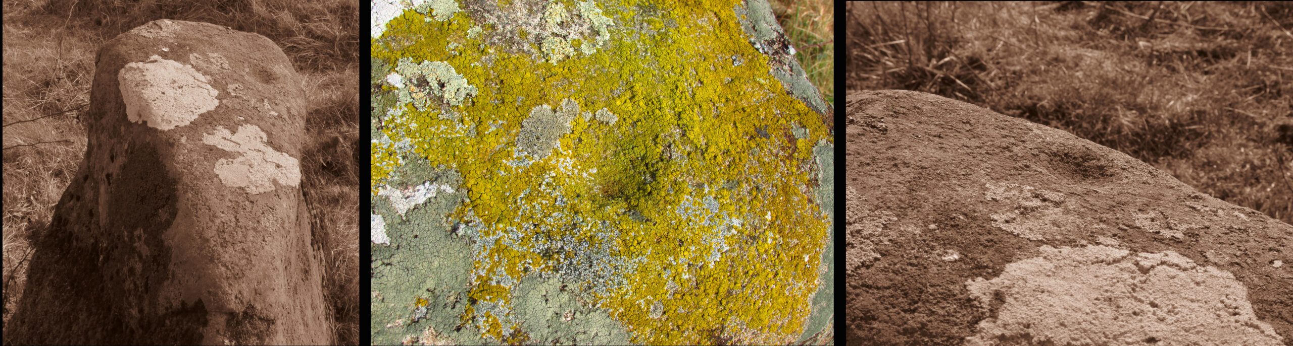
The first time I visited, there were three small polished coloured stones at the foot of the rock, while the second time there were four stones within the cup. A long term resident out walking his dog told me he knew of no folklore relating to the stone, but that over the last thirty years he had kept seeing offerings of stones in the cup, so the rock clearly still has some ritual significance for local heathens/pagans…
Tumulus (destroyed): OS Grid Reference – TL 5801 5874
Archaeology & History
Site marked on 1886 map
In times of olde on this prominent tree-covered hill, a tomb of some ancient ancestor once lived. It had already been destroyed by some retards by the time the Ordnance Survey lads came here in 1885; but thankfully, memory gave its existence the note it deserved. The place had thankfully been given the once-over by some archaeologists in the middle of that century, giving us a pretty good idea as to its size and nature. Measuring some 90 feet across and fourteen feet high, this was no mere toddler!
A Mr W.T. Collings (1846) gave his Intelligence Report to the archaeological journal of the period, from which the following description is gained:
“The excavation of this tumulus in 1845 was made from east to west, commencing from the eastern side, in the direction of its centre, in which, at a depth of about three feet, there was found a cinerary urn in an inverted position, slightly tilted on one side, and surrounded by charcoal and burnt earth. It was filled with charcoal, but contained only one small fragment of bone. This vessel, which was of the simplest manufacture, moulded by the hand, and sun-baked, measured in height five inches, and its diameter at the largest part was five inches and a half. From the deep red colouring, and the general appearance of the surrounding soil, it would seem that a small hole had been first dug, charcoal and bones burnt in it, the vase placed on the fire in an inverted position, and the whole covered up. About ten feet eastward of the central deposit, on the south side of the line of excavation, and half a foot deeper, a deposit of fragments of bone was found apparently calcined, but with little charcoal or burnt earth, forming a layer not more than three inches thick, and two feet in circumference. There were several pieces of the skull, a portion of the alveolar process, inclosing a tooth, apparently that of a young person, pieces of the femur and clavicle, and other fragments. A little to the north of this spot there appeared a mass of charcoal and burnt earth, containing nothing of interest. After digging five or six feet deeper, operations were discontinued; and on the next day shafts were excavated from the centre, so as completely to examine every part, without any further discovery, and in every direction charcoal was found mingled with the heap, not in patches, but in fragments.”
Collings reported the existence of another burial mound a short distance to the south. It was one of at least five such tumuli in the immediate locale, all of which have been destroyed by retards in the area.
References:
Collings, W.T., “Archaeological Intelligence,” in Archaeological Journal, volume 3, 1846.
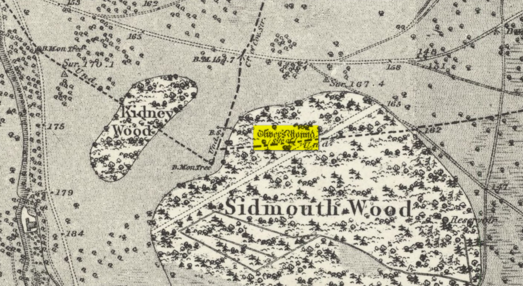
Tumulus (destroyed): OS Grid Reference – TQ 192 735
Also Known as:
Oliver’s Mount
Archaeology & History
Roque’s 1746 map
Oliver’s Mound was highlighted as early as 1746 on John Roque’s map of the Country Near Ten Miles Round (London) as still standing. One hundred and fifty years later, when the Ordnance Survey lads came to map the area, it had gone. We don’t know exactly when it was demolished, so Historic England (not necessarily a good measure of accuracy) tell us its demise occurred “between 1760 and 1868”, so giving themselves at least some degree of safety!
As we can see in Mr Roque’s old map, an avenue of trees led up to the barrow. This avenue will have been created when Richmond Park and its gardens were laid out.
The round barrow was most likely Bronze Age in origin. The historian and folklorist Walter John (1093) reported that in 1834, three skeletons were found at a depth of a yard beneath the surface.
Folklore
Site shown on 1873 map
Traditional tells that the name of this barrow comes from when the religious extremist, Oliver Cromwell, and his men, set up camp here. A slight variant tells that Cromwell stood here to watch a skirmish.
Tumulus (destroyed): OS Grid Reference – TQ 222 709
Archaeology & History
It seems that a great number of prehistoric remains used to exist in and around the Wimbledon Common area. This one is mentioned only briefly in Thomas Stackhouse’s (1833) rare work on early British remains, where he wrote:
“Near an old single-trenched Camp at the South West comer of Wimbledon Common, is a very small flat Barrow cut into the form of a cross: I don’t know that it has been noticed by any writer.”
The “single-trenched Camp” he described is today known as Caesar’s Camp hillfort. By the time the Wimbledon historian William Bartlett (1865) came to write his survey, the site had been destroyed. In Mr Johnson’s (1903) survey, he seems to confuse this site with the large barrow cemetery that used to exist on the northern edges of Wimbledon Common described by William Stukeley and others.
(the grid-reference to this site is an approximation).
References:
Bartlett, William A., The History and Antiquities of Wimbledon, Surrey, J. & S. Richards: Wimbledon 1865.
Johnson, Walter, Neolithic Man in North-East Surrey, Elliot Stock: London 1903.
Tumulus (possible): OS Grid Reference – TQ 2856 7555
Also Known as:
Mount Nod
Archaeology & History
Located on the old boundary line between Clapham and Battersea, what might have been a forgotten tumulus, whose memory was thankfully preserved by the renowned folklorist and historian Walter Johnson (1903), was described in his work on prehistoric Surrey. He seemed to think it serious enough to add to his survey, where he told us that,
“there still exists, near Cedars Road, Clapham, what may possibly be a round barrow. It is in the garden of a house opposite St. Saviour’s Church, and is visible to anyone passing along the old, narrow passage called Wix’s Lane. Mr. J.W. Grover, who brought the matter before the Archaeological Association in 1884, had been struck by the discovery that old maps marked the spot ‘Mount Nod Fields.’ …The mound must originally have been 70 or 80 feet across, but had been tampered with on one side for the construction of an ice-house. Mr. Grover suggested that the mound may be of Celtic date. To us, the height—some 12 feet or more—together with marked signs of reconstruction at a comparatively modern date, indicate the necessity of withholding judgment. The original tumulus may simply have been increased in height, but…digging alone could settle the question.”
Local historian Michael Green (2010) has found that there were prehistoric tombs on Clapham Common only 500 yards away, so this one along Cedar Road was not in isolation. Is the site named on the boundary perambulation records? Has it been explored since Johnson wrote about it and, if so, has its veracity as a prehistoric tomb been ascertained, or is it merely the remains of some post-medieval creation?
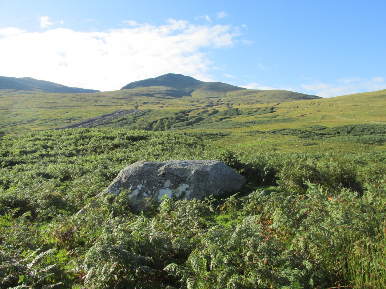
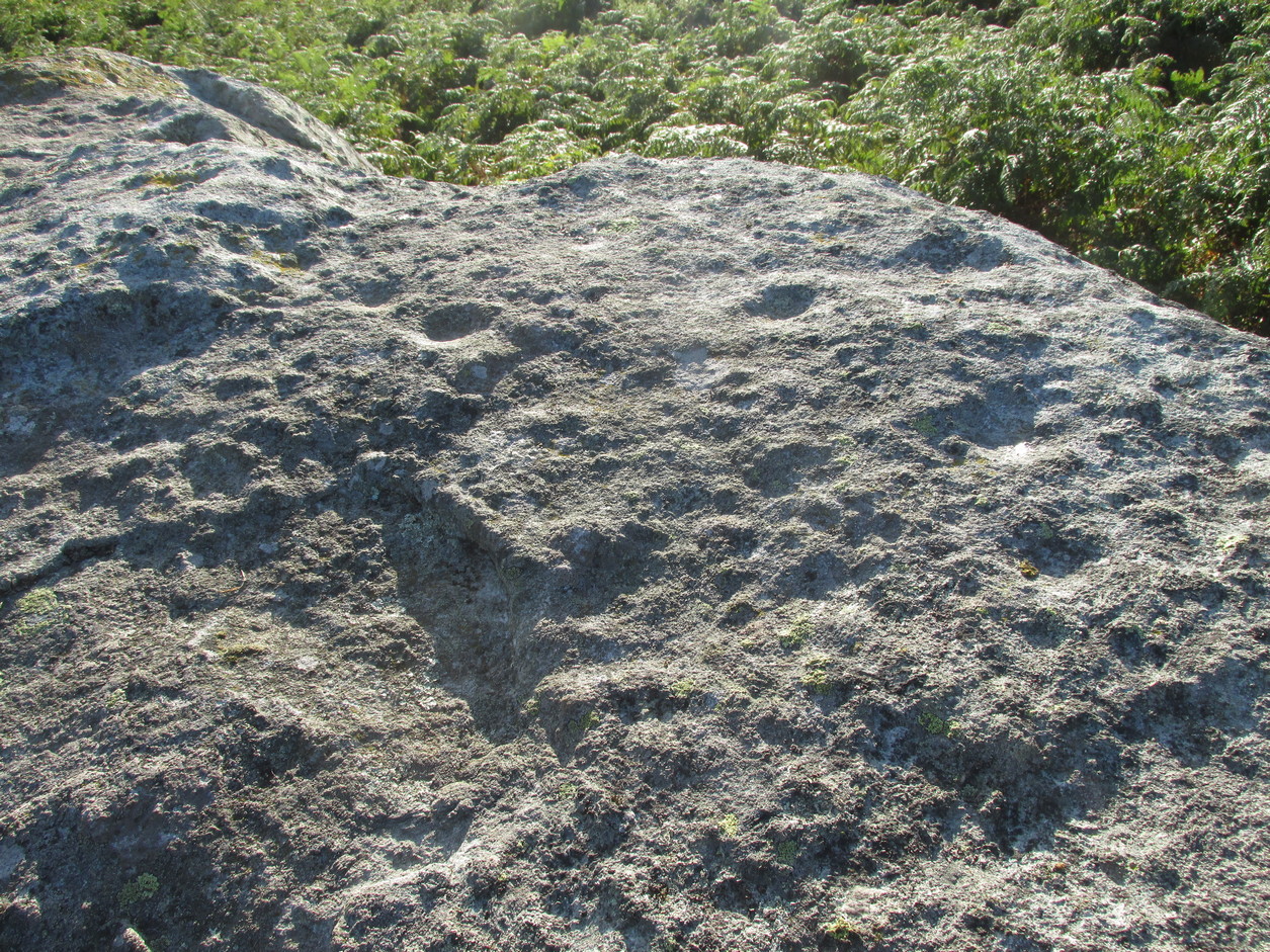
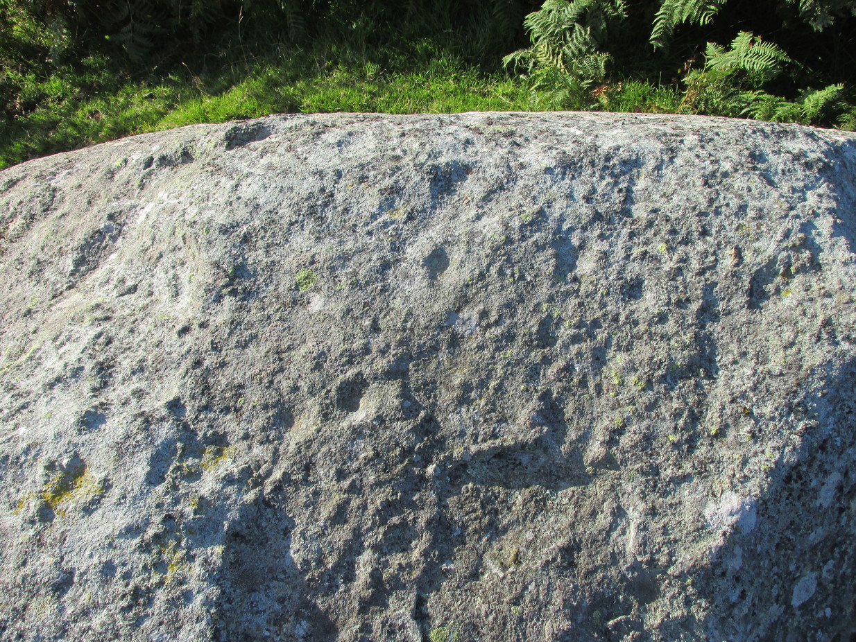
From Killin, take the A827 road to Kenmore. 6 miles along, on your right, is the track down to the Big Shed at Tombreck. Keep on the A827 for exactly ⅓-mile (0.53km), and opposite the driveway to Craggantoul is a small parking spot. A few yards on the road, over the burn, go thru the gate on your left. Follow the straight line of walling up for 400 yards it meets where another line of walling running right (E), into the boggy pasture-lands. Walk along here for roughly another 400 yards then go up the slope as if walking up Ben Lawers (N). You’ll come to 2 large boulders next to each other where the slope levels out. It’s the one on your left!
Archaeology & History
This carving is really for the purists amongst you. It’s like most of the carvings along this contour line in that the design is simplistic. Consisting of at least nine cups all on top of the stone, they can be difficult to see amidst the rough garnet and lichen-encrusted rock.
Cupmarks on its west faceLooking down on the cups
On one of our visits here, when the light cut across the surface at a lower angle, it seemed as if one of the cups had a faint ring around it; but it looked as if the outline of it had been started, but then for some reason the ring was never actually carved. This outline is very faint. We’ve found examples of this at two of the Duncroisk carvings, several miles to the west, where the faintest trace of a ring was outlined, but never carved. Of the cup-marks: five of them are carved on the east-side of the rock and are pretty easy to see (with the ring around one of them), whilst the other four—slightly more difficult to make out—are on its west side. A couple of hundred yards north you can see the Cragganester 10 carving.
Stone Circle (destroyed): OS Grid Reference – NX 7079 5018
Archaeology & History
This stone circle was destroyed sometime in the early 1780s by some moron who cared little for our ancient sites. Its destruction was described by Robert Muter in 1794—the earliest known reference to the site—when he told:
“Near the Roman camp there is a Druidical temple, which was destroyed within these eight years, by the hands of an ignorant Goth, who carried off the stones, split them, and applied them to build a contemptible bridge over an insignificant rivulet, called Buckland Burn. The stones were seven in number, of round granite, and of unequal sizes. The smallest at least three feet in diameter.”
In the 1850s, when the Ordnance Survey lads came this way to map and seek out the place-names of the area, the ‘Clownstane’ was one such place they listed. In seeking an explanation of the word, a local man told them the folk memory from seventy years prior:
“Mr. Bell of Balgreddan says the name Clownstane originated from the Stones of a Druid Circle which stood convenient to this place and which was broken up and removed to build a bridge near by.”
Fred Coles (1895) included the site in his survey of the Kirkcudbright circles, simply reiterating how,
“According to Dr Muter, the stones “were seized by some vandal for the building of Buckland Bridge.””
Stone Circle (destroyed): OS Grid Reference – NX 691 447
Archaeology & History
In an area littered with neolithic and Bronze Age remains, the great Fred Coles (1895) reported a stone circle that was destroyed sometime roughly between 1890 and 1911. When he visited the place with his colleague, Mr E.A. Hornel in 1887, the megalithic ring had already been tampered with. It was, he said,
“found to consist of five granite boulders, all of them large, in situ, and the ridgy grassy hollows of five others—removed, no one can say when. In the centre of this nearly true circle, 90 feet in diameter, is a slight mound, possibly artificial.”
In 1911, when the Royal Commission lads visited the area, they could find no stone circle and reported how “no information could be obtained concerning it” from the local farmer. This might have been because he destroyed it. Some land-owners do such things, as we know; but in this case we may never know.
The site was listed without comment in the Master’s magnum opus (Burl 2000), but he gave it the “uncertain status” category; whilst John Barnatt (1989) questioned whether this was a destroyed stone circle or merely a natural setting that Cole had misinterpreted.
References:
Barnatt, John, Stone Circles of Britain– volume 2, BAR: Oxford 1989.
Burl, Aubrey, The Stone Circles of Britain, Ireland and Brittany, Yale University Press 2000.
Royal Commission Ancient & Historical Monuments, Scotland, Inventory of Monuments and Constructions in Galloway – volume 2: County of the Stewartry of Kirkcudbright, HMSO: Edinburgh 1914.
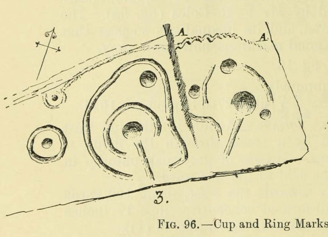
Amongst a good cluster of petroglyphs, this ornate little fella may have been one visited by George Hamilton (1886) when he visited Balmae and outlying districts, seeking out petroglyphs! We don’t know for certain though, as his descriptions are somewhat vague. However, a few years later the great Fred Coles (1895) came a-wandering in search of the same carvings and, as happens in this line of business, uncovered a few new ones during his rummaging. This was one of them, which he described, very simply, as hiding
“but a few yards from Ross View Cottage, on its N.W. … (with) eight cups being associated with four rings and several grooves, both straight and curved.”
It was only a few years later when the Royal Commission lads (1911) came in search of it and they told how,
“the main design is a central ringed cup with a connected groove, and two outer cups which an outer circle curves eccentrically to enclose.”
But when Ron Morris (1979) explored the area in the 1970s, he was unable to locate this and a number of other carvings that had been reported by Coles. Since then, the carving has been relocated at the grid reference cited above. Also since then, a great deal many more carvings have been found in this locale by the experienced petroglyphic fingers of Maarten van Hoek. (1993)
Morris, Ronald W.B., The Prehistoric Rock Art of Galloway and the Isle of Man, Blandford: Poole 1979.
Royal Commission Ancient & Historical Monuments, Scotland, Inventory of Monuments and Constructions in Galloway – volume 2: County of the Stewartry of Kirkcudbright, HMSO: Edinburgh 1914.
van Hoek, M., “Balmae”, in Discovery & Excavation Scotland, 1993.
Turn right off the A93 at Cargill onto the side road by Keepers Cottage and up the hill to Gladsfield Wood at the top on your right. Park up at the top side of the Wood and walk straight along the narrow track for around 450 yards and what may be the remains of the stone will be seen between a pair of mature trees.
Archaeology & History
In 1862 the stone was described in the Ordnance Survey Name Book for Perthshire:
‘And about 150 yards from the same object [Hangie’s Well], in a north-westerly direction, there is a small Standing Stone, having the appearance of the ancient monumental standing stones.’
It seems the stone had been removed by the time Fred Coles (1909) came to see it nearly fifty years later. He told us:
“On the day of my visit the mist was so abnormally dense and confusing that it was with considerable difficulty the wood itself was identified; and as its interior is an utter wilderness of trees, shrubs, brambles, broom, wild roses and tall grass, besides being a pheasantry, it is just possible that the monolith searched for evaded my zeal. I think not, however, because, hearing a hedger at work on the Newbigging side of the wood, I made for him; and after plying him with various questions, could get no statement to the effect that he had, though living so near, ever seen any conspicuously tall Stone in the wood.
“On retracing my steps, I searched a fresh portion of the wood, and noticed one biggish block of whinstone lying on the grass in a slight hollow of the ground. It was somewhat cubical, about 2 feet 6 inches square, and fractured. This may he a portion of the former monolith, possibly; and with this dubious result I had to be content.”
In 1967 the archaeologist O.G.S. Crawford described “a sharp-edged boulder standing near the spot marked on the map,” but was not certain if it was the stone. It had no markings on it.
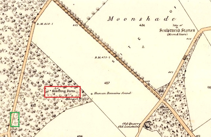
25 in OS map of 1866 showing original position of stone outlined red and position of possible remains of stone in green
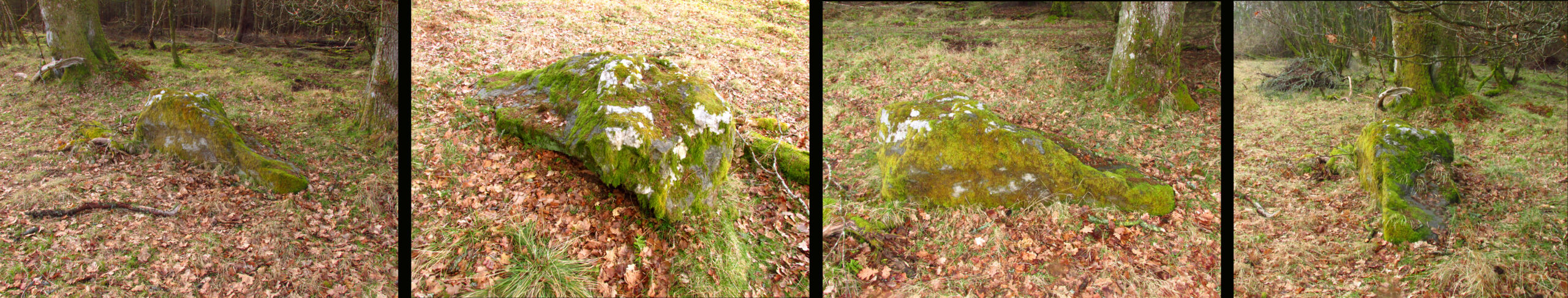
Moving on to 2020, and I found the same impenetrable jungle that Coles described more than a century earlier. When a site has been destroyed I can normally take a photograph of where it once was, but not in this case. I continued westward over difficult and potentially ankle snapping terrain that had recently been replanted with conifer saplings, until I got out of the planting area to a line of mature trees next to the track through the wood.
One large elongated stone presented itself that had clearly lain there for many years judging from the moss growth, a short distance away at NO 15641 35478. Could this be the top part of the standing stone, dragged from its original position some 500 feet to the north-east? It is of grey whinstone, heavily veined at the base, with white quartz and tapering to a pointed tip. It has a squarish base measuring approximately 3 feet across by at least 2 feet deep and is some 7 feet in length. It doesn’t look to be natural, so is it a likely candidate for our missing stone? Felled by a man with a hammer and chisel and dragged by a heavy horse to the edge of the field as part of the ‘improvements’, so beloved of nineteenth century landowners…
We can’t prove it is the remains of Hangie’s Stone which may, after all, still lie buried in the boscage…
The possible remains of Hangie’s Stone
The stone in its original position was next to the Roman road from Camelon via Stirling and Muthill to Kirriemuir near to the junction of a road to Inchtuthill Roman Fort, so may have once been a way marker, although it is not of Roman origin.