Standing Stone: OS Grid Reference – SE 01814 42411
Getting Here
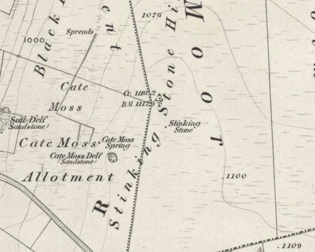
One of two ways to get here really. The easiest is from Sutton-in-Craven: go through the village and up the steep hill (don’t take the right turn as you start up the hill). Go all the way up until the hill starts to level out and on the left-side of the road you’ll notice a boundary stone stood upright (this is the Sutton Stoop). Stop here. Of the 2 gates, climb over the top-most one and walk down the path into the adjacent field, heading over to the gap a couple of hundred yards away where the gate to another field is. That’s it!
Archaeology & History

Now here’s a weird one. With a name like this you’d expect there to be plenty of info or historical comments. But despite all the books and journals in my huge library, aswell as visiting town libraries and exploring the resources on-line, there’s nowt written about this ‘ere spot. Not a jot! Even the usually satisfactory place-name fellas have a thing-or-two to say about sites with names such as this—but even their old tomes are closed-lipped. Hmmmmm…..
I visited the place several times to try ascertain what this site was, thinking — perhaps — that it was an old boundary stone whose name had been convoluted from some older, more obvious title.* The nearby Sutton Stoop boundary stone, right by the roadside, seemed a good indicator to such an assumption, as it was a recognised boundary marker with written history and a meeting point along the local perambulation. But the curiously-named Stinking Stone was neither on the same line, nor ever had been according to old records, and couldn’t be located either. There had been obvious quarrying and other industrial destruction along the hilltop where the old stone was marked and it seemed logical to assume that it had been destroyed in bygone years by that usual breed of capitalist industrial halfwits. Until a psilocybin venture one afternoon, last season…
Twas a lovely sunny day, though windy on the tops as usual. I was out with a couple of neophytes showing them Psilocybes and various other species, chewing them here and there and talking the way of healthy usage. We passed by an old well, long forgotten, before heading onto Stinking Stone Hill. Bimbling somewhat, and ruminating about the moss of colour, we decided to sit by the walling in-field and dream for a short while. As we hit the old gate the Stinking Stone came up right before us. Literally!
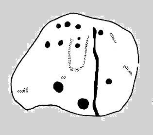
There in the old walling, blunt as you like, stood this four-and-a-half-foot tall standing stone, smoothed on one side by a short aeon of weathering, upright and proud as if it had been stood there for centuries, awaiting attention! I exclaimed a few triumphant expletives; rubbed myself here and there over the old thing, then sat for a while behind the wind with the old upright, solidly embedded in old earth — then awaited the dream…
Twas a good day…
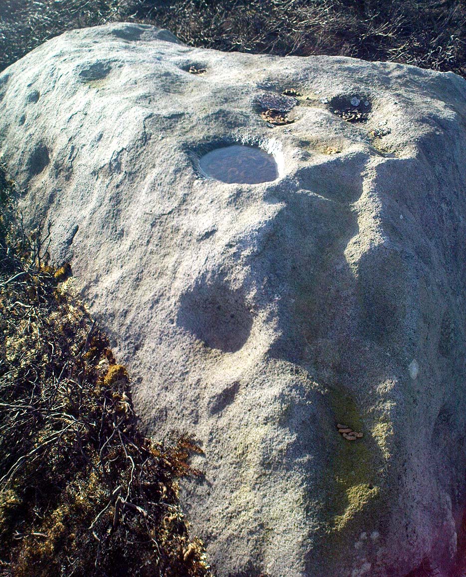
And then I returned home and later sought what I could on a possible etymology. Around the hilltop a hundred yards away were small depressions and the faded remains of industrial workings, like I said; and with this in mind the awesome Mr Wright (1905) told us about the existence of ‘Stinking coals’, “an inferior kind of coal” no less. Referring us to a work from 1818, we’re told,
“The Stinking-coal is noted for containing a great proportion of sulphuret of iron, thick seams or layers of these pyrites running in it. In consequence of this it cannot be used for smelting purposes.”
Another account from 1868 telling us that:
“On opening the body, it contains a strong sulphureous smell, characteristic of the disease; hence it is called the stinking ill; and the stomach and bowels are prodigiously distended with air, having the same intolerable foetor.”
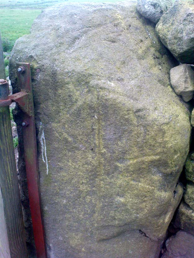
This old worn gatepost however, perhaps has a history that only goes back a few centuries. It has been cleaved in half, as you’ll see if you visit it; but its western face is old and worn and it’s been embedded in the ground for a long time. On its northern face are the curious etchings of carvings, which are more akin to wounds from some past offence (perhaps when it was split in half), cleaved by metal toolings and dragged by farmers to be fixed in into present spot. It’s history may not be truly ancient. Twouldst be good to know for sure though…
References:
- Wright, Joseph, The English Dialect Dictionary – volume 5, Henry Frowde: Oxford 1905.
* ‘Stinking’, stone-king or King Stone? Unlikely though…
© Paul Bennett, The Northern Antiquarian