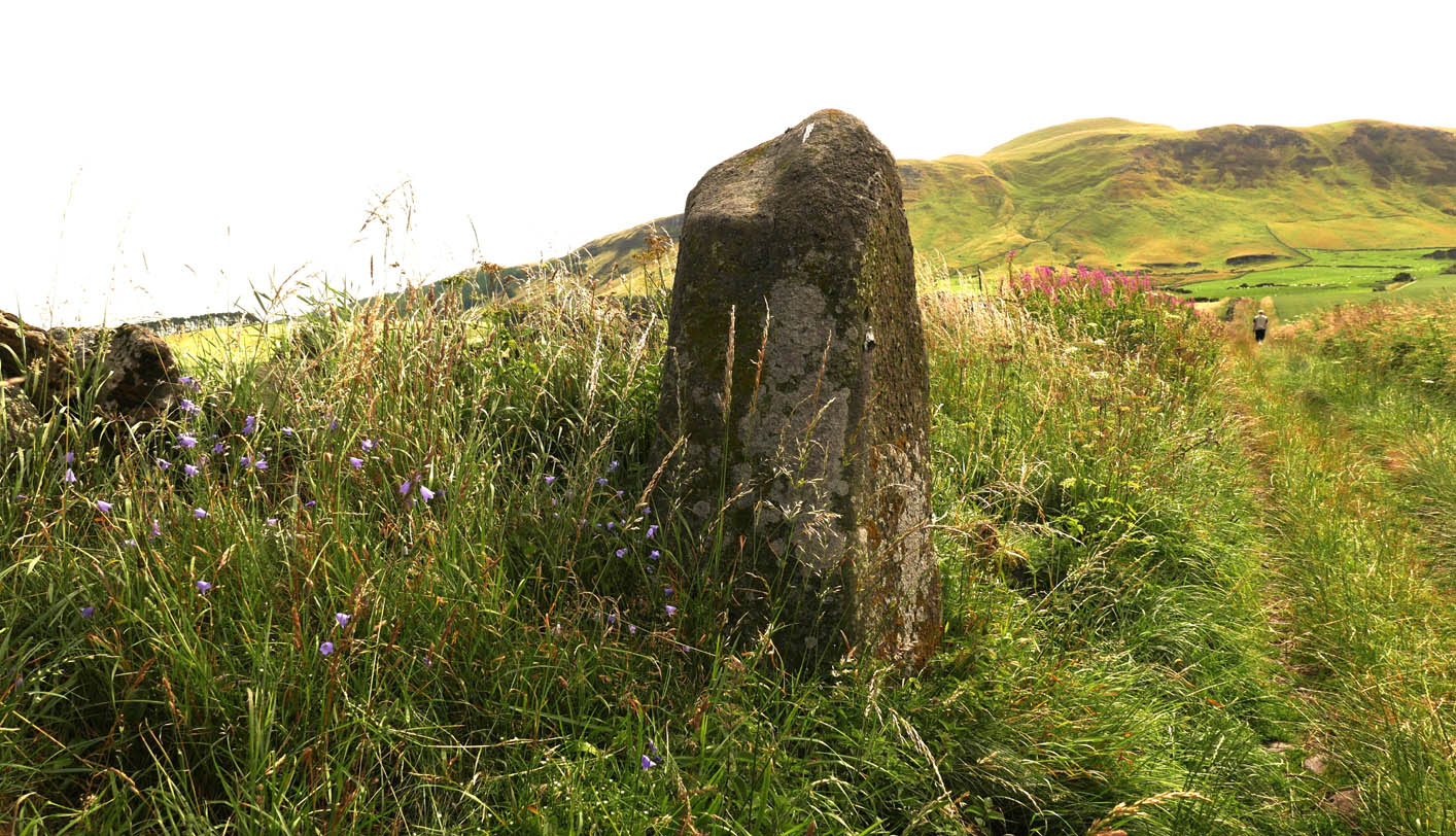
To find this stone take the A91 to Gateside and turn into Station Road. Follow to the end, then turn right. 200 yards on there is a parking spot for the Bunnet Stane, and a track to follow. As you go up this track towards the Bunnet, approximately 280 yards on is this beauty.
Archaeology & History
At over 6ft high, this previously unrecorded standing stone has quite a presence on this slight incline. It’s hard to tell the true height as he is set in a grassy bank with a drystane wall behind. It has obviously been used as a gatepost at some time in the past, but there’s no hint of being moved for that purpose. There are many ancient relics in this area and there used to be a stone circle across the road and behind Nether Urquhart Farm, along with several burial cairns. I reckon there is a lot more to be found, and we fully intend to go back there.
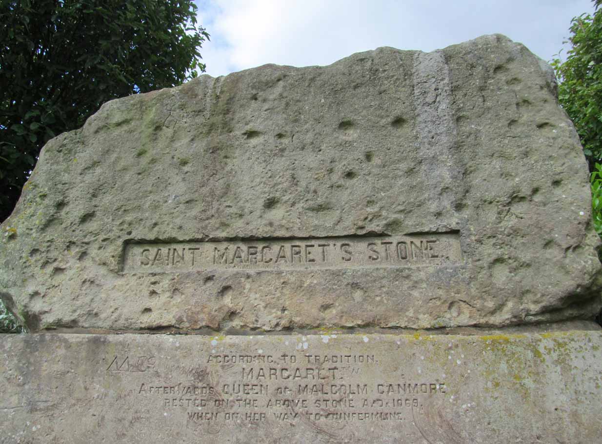
Take the A823 road out of Dunfermline south towards Rosyth. A half-mile before you hit the motorway roundabout, at the roundabout where Carnegie Avenue takes you east, turn west and park up along the road where the modern business park lives. 30-40 yards from the roundabout, set back on the pavement, you can’t really miss the huge flat slab of stone, covered in cup-markings, resting on a stone plinth with ‘St Margaret’s Stone’ stamped on it!
Archaeology & History
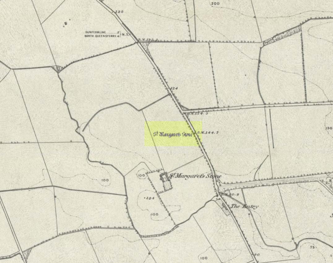
On the 1856 OS-map of this area, St Margaret’s Stone is shown at the roadside just above a farm of the same name, a short distance away from its present location. In October 1879, Alexander Stewart (1889) told us that funds were raised and steps taken to properly fix and preserve this ancient ‘resting-place’ of Queen Margaret on the Queensferry Road. It was quite a few years later before it was moved the few hundred yards further to its present location.
Cups on stone’s edge
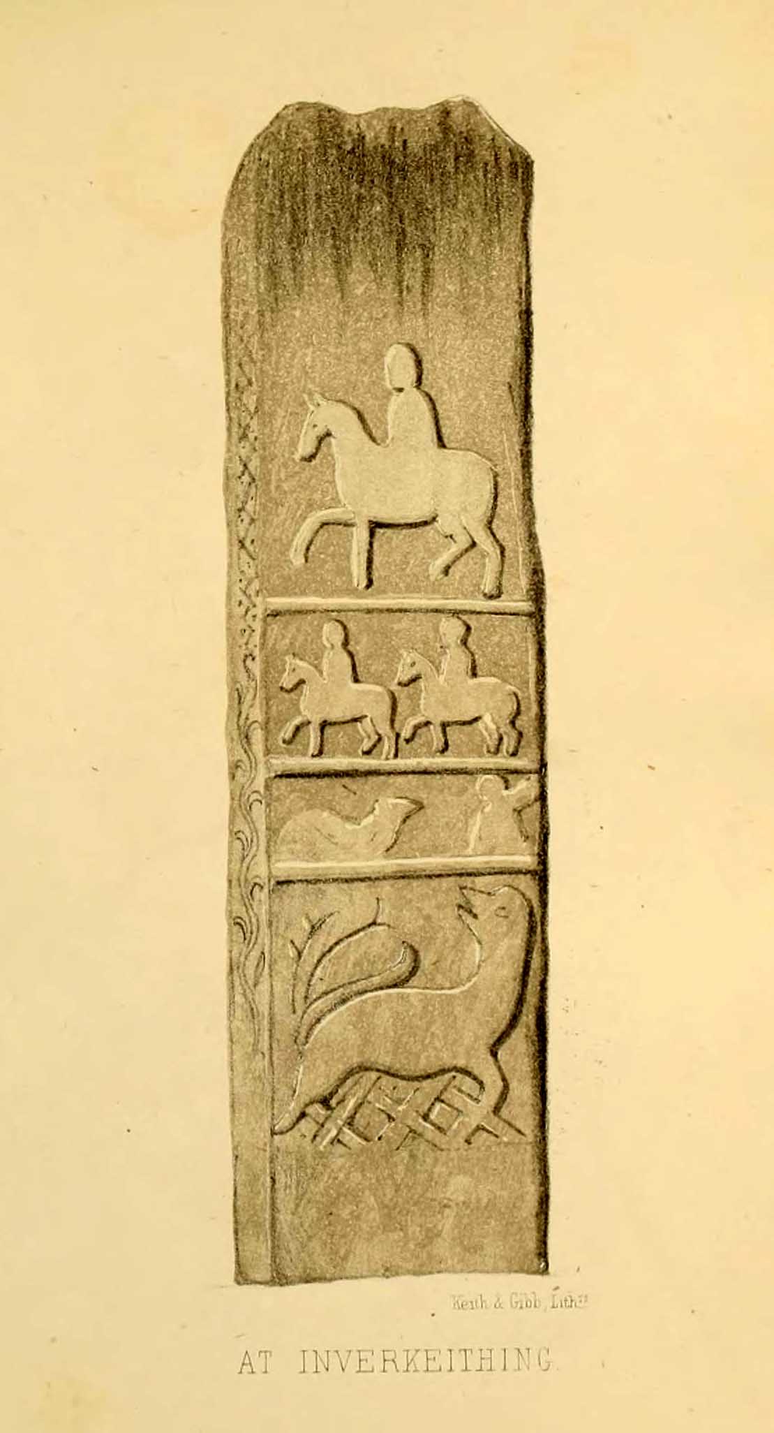
Early writers tell us that originally its position in the landscape was on the crest of one of the rises in the land between Dunfermline and the sea, making it visible for some considerable distance. This would seem to have been a deliberate placement. In my mind, and in accordance with the placement of many a prehistoric tomb, St Margaret’s Stone may originally have been part of a neolithic or Bronze age cairn, long since gone. The size and shape of the rock implies it too, with similarities here of the impressive cist or gravestone found inside the Netherlargie North cairn at Kilmartin. However, this wasn’t the thought of the prodigious Scottish historian, William Skene. He thought that St Margaret’s Stone originally stood upright, being a Pictish-style standing stone that was mentioned in the first Statistical Account of the area. The brilliant Scottish antiquarian, John Stuart (1856)—who gave us an illustration of the ‘standing stone’ in question—told us:
“It has been supposed by some that “St. Margaret’s Stone,” a block now lying on the side of the highway leading from Inverkeithing to Dunfermline, and about midway between these places, can be identified with the standing stone referred to in the Statistical Account. Mr Skene has noted below a sketch of St. Margaret’s Stone:- “The sculpture upon this stone has been lately chipped off in mere wantonness, so as to leave few traces of the subject recorded upon it.” He farther states that it formerly stood erect, and was called “The Standing Stone.” According to Mr. Skene’s measurement, St. Margaret’s stone is about nine feet and a half in length, one foot in thickness, and four feet broad at the widest end, and broken off to a narrow point at the other.”
The missing ‘standing stone’
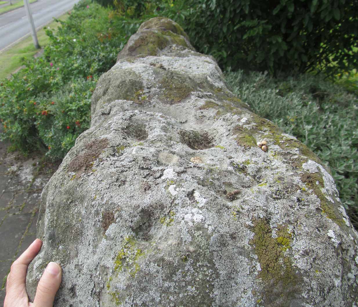
In this instance, Skene was confusing St Margaret’s Stone with the lost Pictish monolith (left) that used to exist nearby, which had carved horse figures and other memorial designs upon it and which he thought had faded away. Whereas the large slab we are looking at here, and which Skene visited and measured, is covered on one side by a gathering of prehistoric cup-markings—much earlier than any Pictish or early christian carvings. At first glance, it seems that some of these cups may well be natural, but it has to be said that some of them are distinctly man-made. And if we were to believe the archaeo-accounts of the stone, the cupmarks are only to found on one side of the stone. This is incorrect. As we can see here, a number of cupmarks run along the edge of the stone. We cannot say for sure whether all of them are artificial, but they certainly look like it! Also, on the other side of the flat surface, one or two single cups are visible. It would be good if we could get an artist to give us a detailed impression of the prehistoric carvings without the modern engraving of St Margaret’s Stone etching on the main face. (is there anybody out there!?)
The Royal Commission (1933) lads visited the stone in 1925 and, several years later in their write-up, told us simply:
“This stone…stands with its main axis due north and south and measures 8 feet 6 inches, by 4 feet 7 inches, by 1 foot 6 inches. On one side the entire surface is cup-marked, the markings varying in size from 1¼ inches to 3¼ inches and having an average depth of from ½ to ¾ inch.”
When the Scottish petroglyph writer and explorer, Ron Morris (1968) came to the site, he gave it an equally brief description, merely telling us:
“On standing stone (8 1/2 feet high, 4 1/2 feet wide), built in to roadside fence, over 80 cups, up to 4in in diam, 3/4in deep, some run together as rough dumbells.”
It’s well worth checking out!
Folklore
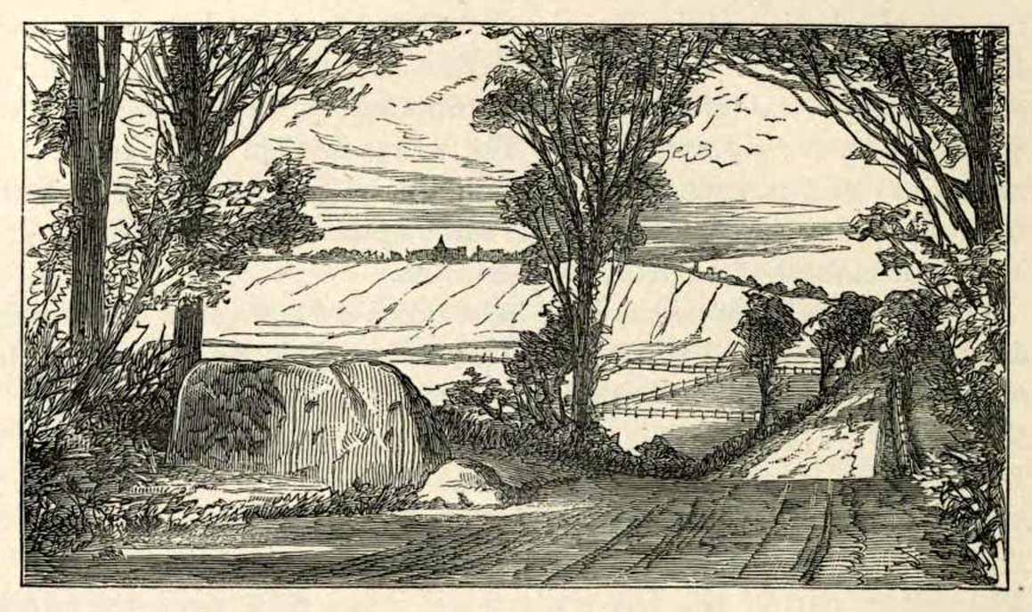
St Margarets Stone in 1825
When the Saxon Queen Margaret landed on the shores just west of Queensferry at Rosyth Castle (NT 1087 8200), legend reputes that she and her entourage made Her way north towards Dunfermline. Halfway along the ancient track She rested at this large stone which, thereafter, gained the name by which we know it today. It was said that Queen Margaret subsequently visited the stone on a regular basis for periods of solitude. The tale probably has some germ of true in it. Additional ingredients also told that,
“The large stone here is associated with St Margaret and was visited by women who hoped to conceive or sought a successful birth. The eight-foot high stone is said to mark the resting place of St Margaret when she journeyed between Queensferry and Dunfermline. Margaret had eight successful pregnancies and probably needed to rest quite a few times on her travels!”
The fertility aspects of the rock were not the only pre-christian virtues attached to it. We also find that oft-cited motif of rocks moving of their own accord: in this case, as J.B. MacKie (1905) told us, local people had always
“been told that the stone rose from its bed and whirled thrice round in the air every time it heard the cock at the adjoining farm crow.”
Cocks crowing are symbolic of sunrise, obviously, and this lore may simply represent a folk memory of the spirit in/of the stone being animated at that time of day. It’s a motif found at ancient sites all over the place!
Royal Commission Ancient & Historical Monuments of Scotland, Inventory of Monuments and Constructions in the Counties of Fife, Kinross, and Clackmannan. HMSO: Edinburgh 1933.
Rupert-Jone, John A., Rosyth, A. Romanes: Dunfermline 1917.
Stewart, Alexander, Reminiscences of Dunfermline and Neighbourhood, Scott Ferguson: Edinburgh 1889.
Standing Stones (destroyed): OS Grid Reference — NO 4128 1769
Also Known as:
Dairsie Stones
Archaeology & History
View of the field where the stones stood (Paul Hornby)
Recent archaeological investigations at the site which has become known as the Dairsie Hoard—where many pieces of broken Roman silverware were seemingly deposited in one spot, adjacent to a dried bog “which may arise from a former spring” of water—brought about the discovery of much earlier megalithic remains. The position of two previously unrecorded standing stones were found during the archaeological dig here. In the most recent edition of Current Archaeology, Fraser Hunter (2018) described the position of the Roman silverware close to some ancient pits or sockets in the ground. This “group of features was…intriguing”, he told,
“for two of them contained stumps of standing stones, one in association with probably Bronze Age pottery. This hoard had been buried in a memorable, perhaps even a sacred site, between an intriguing wet spot on one side and, on the other, two standing stones, which were already ancient by the time the silver was buried. Such burial of valuables in association with prehistoric monuments can be readily paralleled elsewhere. It suggests this silver was placed under the care of the gods, probably as a sacrifice rather than a burial for safekeeping.”
Two thousand years before the Roman silver deposit had been deposited, megaliths here stood. Sadly they’re long gone, leaving more questions than answers as usual…
References:
Hunter, Fraser, “Solving a Silver Jigsaw,” in Current Archaeology, 335, February 2018.
Acknowledgments: Many thanks to Paul Hornby for use of his photo in this site profile.
There are no previous literary references to this small portable cup-marked rock, relocated recently by Paul Hornby during one of his various antiquarian meanderings. Found in association with a much later architectural structure, it position in the landscape (near the top of a hill) would suggest that is was most probably located in a prehistoric cairn in earlier days—all traces of which have vanished. But we cannot be sure of this and I’m merely speculating.
Moonzie cup-marked stone
Site of carving
The thin, fairly flat stone is about 18 inches across, by a foot wide, and consists of what seems to be 10 cup-marks (no rings, sadly), of which six of them are the real deal. No other carvings officially exist anywhere near it and its isolation is an enigma… such as it is with petroglyphs…
Due to the fact that the stone can literally be picked up and moved by anyone, we’re hoping that it can be seen by local archaeologists and perhaps placed into a museum for safe-keeping.
Travelling South along the A916 just past Craigrothie, turn right down to Chance Inn, and turn left at the T junction. and follow the road on to just past the left hand bend when Waltonhill Farm will be seen on the right. The Stones form part of the structure of a dwelling house and are not accessible to the public, but are visible from the public highway further down the road as the light coloured irregular shaped stones at ground level either side of the door of the south-facing house.
Archaeology & History
According to a piece published in the Fife Herald & Journal in 1905:-
“Once upon a time, so runs the legend, Samson challenged the devil to match him at boulder throwing. As challenger, Samson stood on the West Lomond; Satan stood on the East. The signal was given; two mighty rocks whistled through the air. ‘The De’ils Stane‘ fell where it now lies, on the road-side about a quarter of a mile west from Waltonhill Farm. Samson, though handicapped by three miles greater distance, flung his stone fully four hundred yards beyond that of Satan, and with such force that it split into three parts; which parts are now built into Waltonhill barn.”
The light-coloured stones at ground level are the likely remainsAnother view of the stones
This is of course a variant of a creation myth that is to be found throughout Britain, of an Age of Giants who strode the land quarrelling with each other and the mortal humans. The original names of the Giants have been lost in the aeons of oral transmission of the legend from pre-history, and replaced by that of a probably equally legendary Middle Eastern strong man from the Christian’s Bible, in combat with the Christian’s Naughty Man. And to prove the point of Christianity’s superiority over the old animistic cults of the land, the De’il has to be demonstrably the Loser.
The house owner told me that what is now the farmhouse bearing the stones, was originally the barn, that they rebuilt after 40 years of dereliction, and interestingly she had heard something about some Samson’s Stones, but not about the nearby De’il’s Stane, which shows that these ancient legends are still being orally transmitted.
The stone was thrown over 10 miles from West Lomond (right)
There are five ‘odd’ stones either side of the doorway, along the base of the wall facing the Lomond Hills, of irregular shape and lighter colour than the rest of the building’s walls. These are the likely candidates for the Samson’s Stones (unless anyone can come up with more convincing evidence). While the legend speaks of three stones, it is quite feasible that the masons dressed these when they built the original barn, making five stones out of the three. They look like they may be successive horizontal slices of a larger square to triangular sectioned stone. Pure speculation on the writer’s part, but are these the remains of a lost standing stone(s) that had to be demolished in order for the barn to be built, pieces of which were incorporated into the building to give the original stone’s magical protection to the farmer’s animals and crops?
References:
Fife Herald & Journal, 1st November 1905, quoted in John Ewart Simpkins’ County Folklore – Volume VII: Fife, with some notes concerning Clackmannan and Kinross-shires, Folk-Lore Society by Sidgwick& Jackson: London 1914.
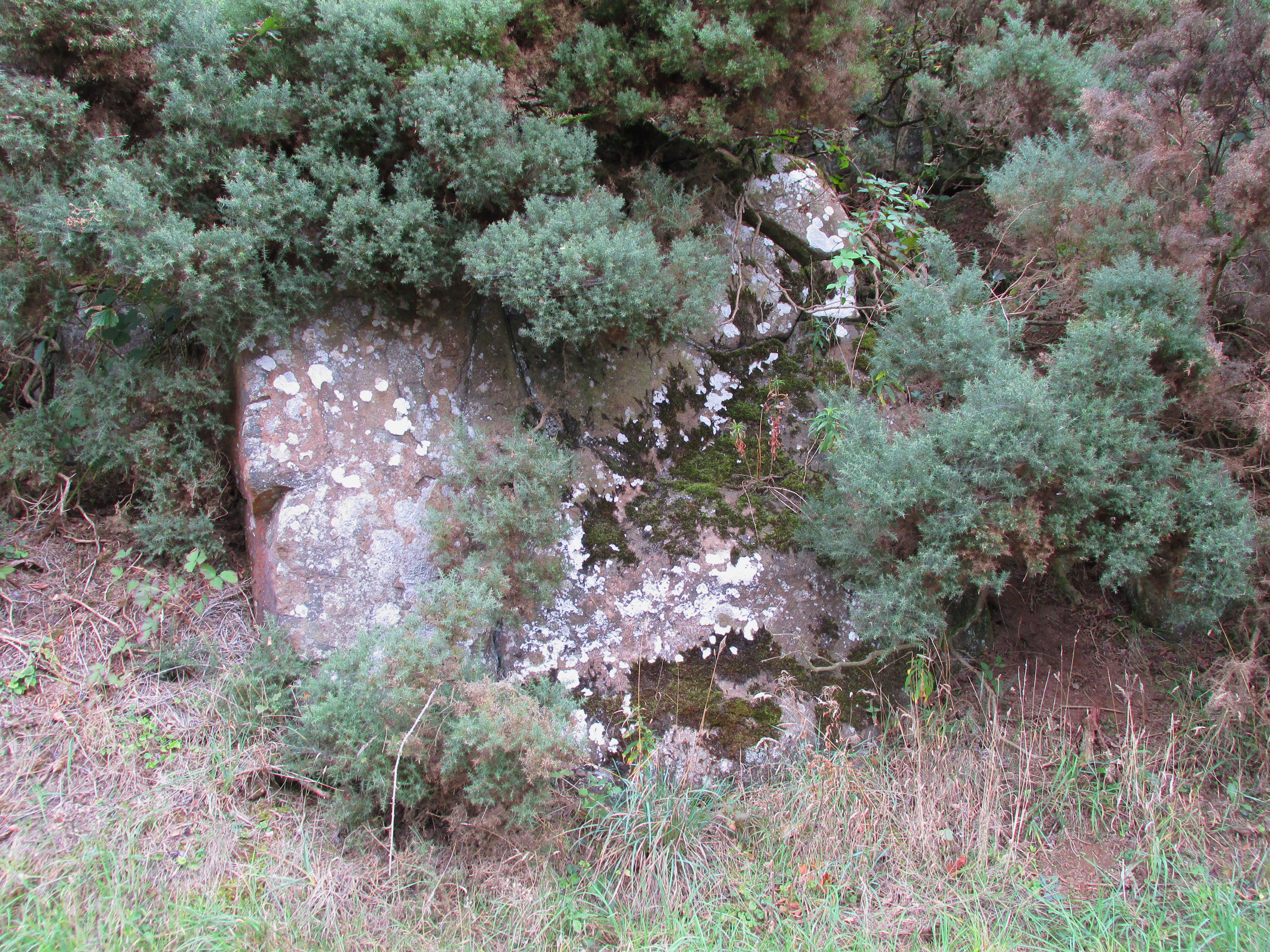
Travelling South along the A916 just past Craigrothie, turn right down to Chance Inn, and turn left at the T junction. and follow the road on to just past the left hand bend when Waltonhill Farm will be seen on the right. Continue south down the road a few hundred yards until it takes a slight right turn. The De’il’s Stane, a huge flat faced slab of rock, will be seen at the roadside on the left side of the road, partly obscured by gorse.
Archaeology & History
According to a piece published in the Fife Herald & Journal in 1905:-
“Once upon a time, so runs the legend, Samson challenged the devil to match him at boulder throwing. As challenger, Samson stood on the West Lomond; Satan stood on the East. The signal was given; two mighty rocks whistled through the air. ‘The De’ils Stane’ fell where it now lies, on the road-side about a quarter of a mile west [sic] from Waltonhill Farm. Samson, though handicapped by three miles greater distance, flung his stone fully four hundred yards beyond that of Satan, and with such force that it split into three parts; which parts are now built into Waltonhill barn”.
The roadside location, just south of the bend
The De’il’s Stane, a huge slab of rock!
This is of course a variant of a creation myth that is to be found throughout Britain, of an Age of Giants who hurled rocks around and strode the land quarrelling with each other and the mortal humans . The original names of the Waltonhill Giants have been lost in the aeons of oral transmission of the legend from pre-history, and replaced by that of a probably equally legendary Middle Eastern strong man from the Christian’s Bible, in combat with the Christian’s Naughty Man. And this was of course done to prove the point of Christianity’s superiority over the old animistic cults of the land, and the De’il had to be demonstrably the loser.
De’ils Stane thrown by the Man in the Red Velvet Suit from East Lomond (Left)
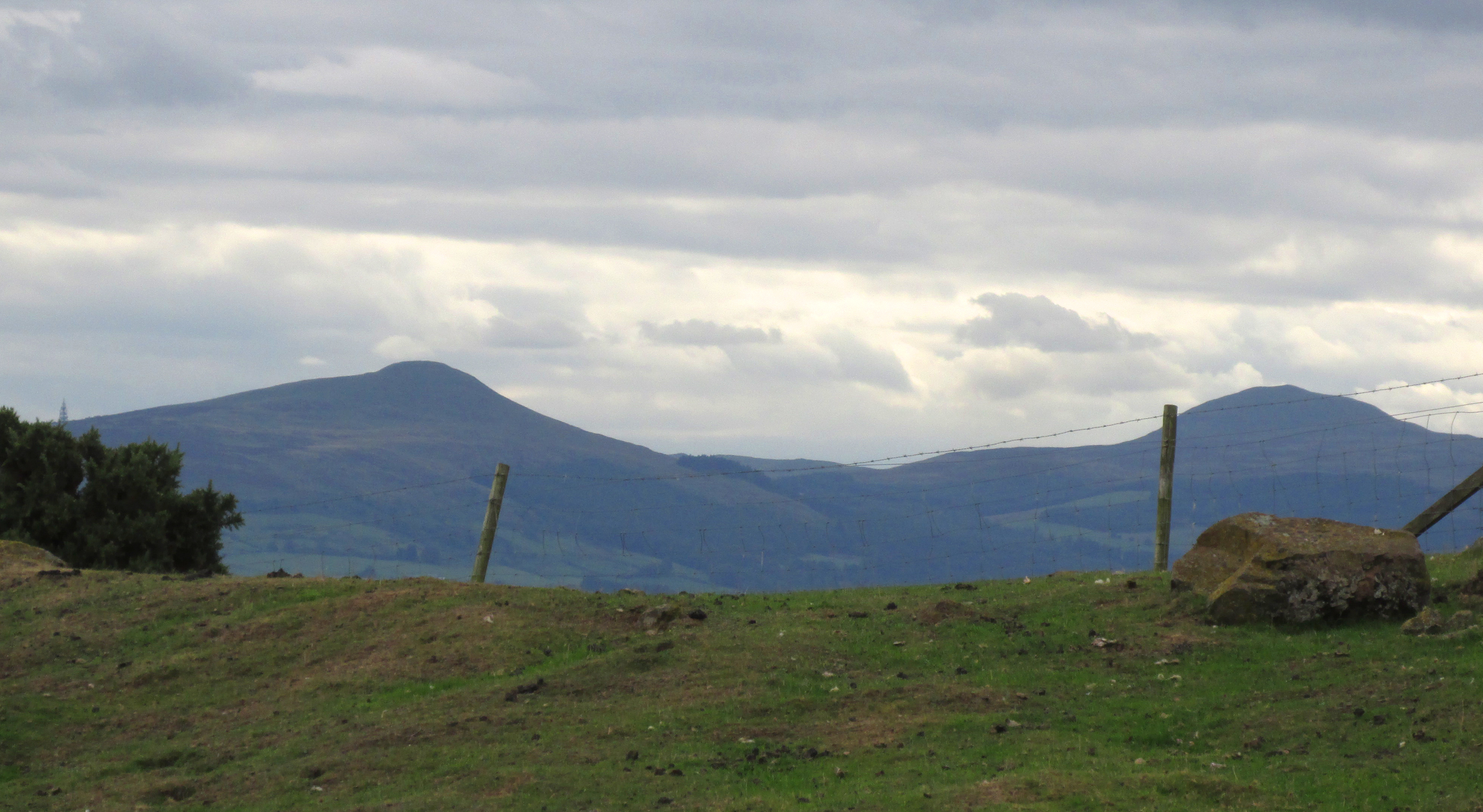
Owing to the Stone being partly hidden by gorse, it was not possible to make a close inspection of the rock for carvings etc. A further visit will no doubt be made to try to clear some of the gorse so a closer inspection can be made. The Stone’s size (approximately 15′ high by 20′ wide by 4′ thick) and the way it is resting against a natural bank, does give a credence to the legend of its having been slung by a giant from East Lomond, clearly visible nearly 7¾ miles away.
Reference:
Fife Herald & Journal, 1st November 1905, quoted in John Ewart Simpkins’ County Folklore – Volume VII: Fife, with some notes concerning Clackmannan and Kinross-shires, Folk-Lore Society by Sidgwick& Jackson: London 1914.
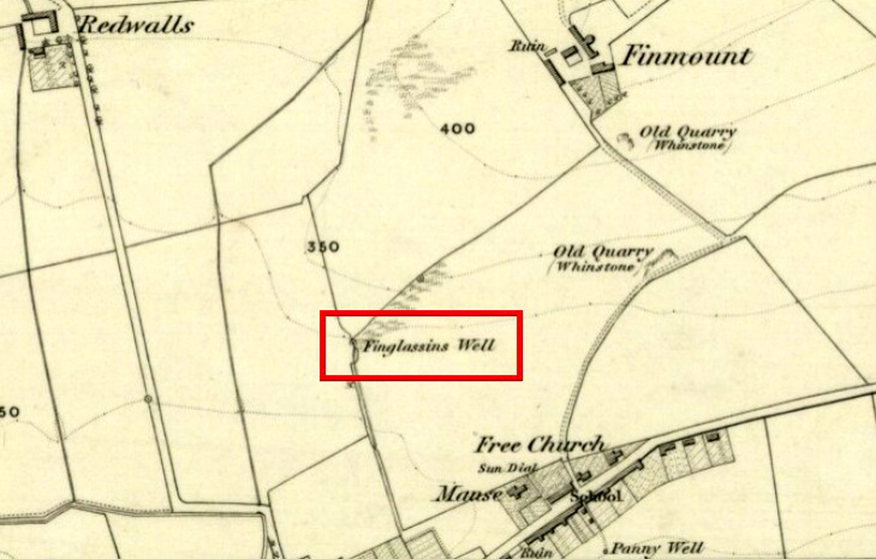
In Kinglassie village, from the Main Street follow Redwells Road and turn right where it forks and follow the track until you get to the derelict ground; then turn left up the slope, following the eastern (right hand) edge of the wall up to the well.
Archaeology & History
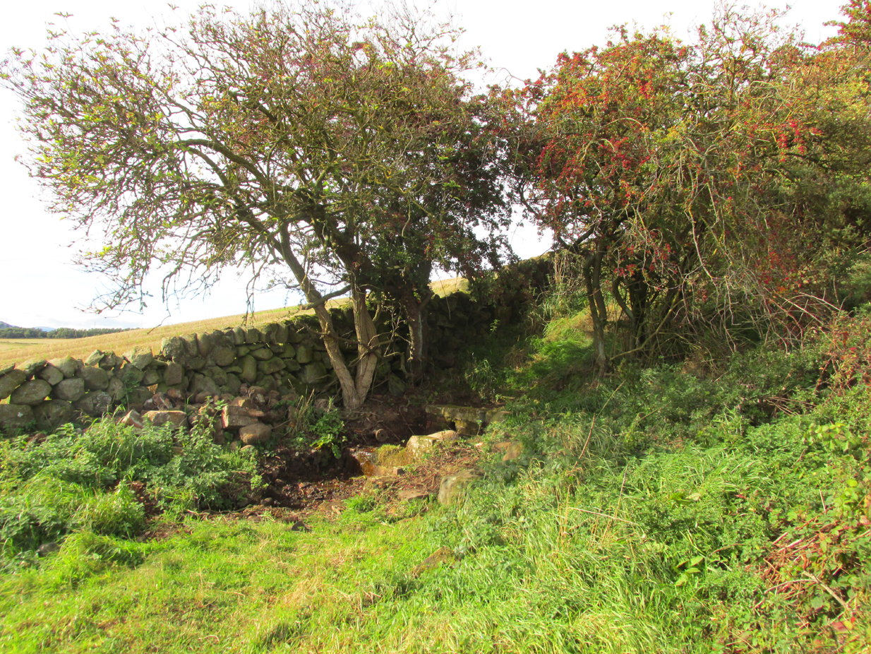
Under its bower of hawthorn & elder
Sheltered under its bower of hawthorn and elder bushes, at a distance it has the romantic look of an ancient holy well. But close up, the spring issuing from Finglassins Well shows evidence of having been connected up to the public water supply, with ugly brickwork and pipes obliterating any previous structures that may or may not have existed there. There even seems to be doubt as to its name. Ordnance Survey and Nicolson Street Atlas show it as ‘Finglassins Well’.According to the Canmore citation, which lists it as ‘St Finglassin’s Well’ or ‘St. Glass’s Well’:
This spring is now piped into a trough. There are several boulders nearby but no dressed stone and it is doubtful if there was ever any structure here. It is known by both names.
A well of fine water…
Past industrial despoilation..
So who was the patronal saint, who is remembered variously as Finglassin, Glass, Glascianus, and Glastian? There seems to be some difference of opinion among the various sources, even as to whether any saint existed at all. Alban Butler, in his Lives of the Saints, tells:
“St. Glastian, Bishop and Confessor in Scotland: HE was a native of the county of Fife, and discharged in the same, during many years, the duties of the episcopal character with which he was honoured. Amidst the desolation which was spread over the whole country, in the last bloody civil war between the Scots and Picts, in which the latter were entirely subdued, St. Glastian was the comforter, spiritual father, and most charitable protector of many thousands of both nations. He died in 830, at Kinglace in Fifeshire, and was particularly honoured in that country, and in Kyntire. According to the ancient custom of that country, his name is frequently written Mac-Glastian, the word Mac signifying son.”
Bishop Forbes of Brechin, writing of St Glascianus in Kalendars of Scottish Saints:
“Of the life of the saint we have no details. The collect in the Breviary runs in these terms – ‘Grant we beseech Thee, Almighty God, that we, who celebrate the anniversary of blessed Glascianus, Thy confessor and bishop, may by the intercession of his devout prayers, be deemed meet to attain to eternal joys through out Lord’ He is known in the parish of Kinglassie (or Kinglassin), near Kirkcaldy, of which frequent mention is made in the Register of Dunfermline.”
In the Old Statistical Account of 1792, Reverend James Reid, writing of the origins of Kinglassie:
“It is the opinion of some, that the name is originally Gaelic, and expressive of the situation; others trace it from a saint, whose name was Glass, and point out a well of fine water, called St. Glass’s well.”
Reverend J.M.Cunnynghame, in the New Statistical Account of 1845 wrote:
“While some have supposed that the village after which the parish is called, derives its appellation from a spring denominated St Glass’s Well, others, with apparently greater reason, have traced the name to Gaelic words signifying the ‘head of grey land’. This idea seems to be corroborated by the large extant of inundated, marshy, and mixed surface which….still stretches itself to the immediate vicinity of the village. The preferable conjecture concerning the the derivation of the name acquires additional support from the circumstance, that a locality, somewhat elevated above the channel, along which the water runs from the swamp alluded to, has received the appropriate designation of ‘Finglassie’ signifying the ‘termination of the gray land, or mixed bog.”
W.J.Watson, in The Celtic Place Names of Scotland gives the derivation of Kinglassie from the gaelic ‘cill glaise’ – ‘church of the brook’, and further:
“A well near the church is known as St Glass’s Well or St Finglassin’s Well. Here again, the stream ‘glais’ on which the church stands has been made into a saint; Findgassin is ‘find glaisín’ – ‘holy streamlet’. Near the church is an eminence called Finmont, for ‘finn monad’, later ‘fionn mhonadh’ – ‘white hill’, here probably ‘holy hill’. The real saint of Kinglassie is unknown.”
A closer view
I am inclined to discount Cunnynghame’s laboured interpretation in view of Watson’s later linguistic analysis, as well as bearing in mind he was a minister of a Kirk that went out of its way to deny and denigrate the native pre-Reformation saints. Because of its position and ambience despite past industrial despoilation, I am inclined to a saintly attribution to the well, which as in so many cases in Scotland has lost its true history owing to the depredations of the Reformation. If Watson’s interpretation of ‘Finmont’, ½ mile north-east of the well, is indeed ‘Holy Hill’ then Finglassins Well may have been a part of an ancient, perhaps heathen ritual landscape.
References:
Reid, James, Parish of Kinglassie, Old Statistical Account, Fife, 1792.
Cunnynghame, J.M. Parish of Kinglassie, New Statistical Account , Fife, 1845.
Butler, Alban, The Lives of the Fathers,Martyrs and Other Principal Saints, James Duffy: Dublin 1866.
The multiple-ringed petroglyph of Raith, Kirkcaldy
On the more south-side of Kirkcaldy, head for the roundabout at the meeting of the A910, B925 and B9157, heading out west along the Auchtertool road; but just 60-70 yards past the roundabout, take the first right along Raith Drive. Wibble along here for a few hundred yards until you reach Raith Gardens. Walk down here for 50 yards and cross onto to the grasses opposite where a path runs parallel with a large old stone wall. Barely 2 feet above ground level, keep yer eyes on the walling!
Archaeology & History
Close-up of the carving
This is a peculiar one. A very peculiar one! Found embedded in some very old walling, it is similar in size, style and design to the curiously un-eroded multiple-ringed Binn-1 petroglyph 3.9 miles (6.2km) southwest, this concentric four-ringed ‘cup-and-ring’ stone actually seems to have no central cup. That aint too unusual. But the oddity here is its complete isolation—not merely from any other petroglyphs, but from any other neolithic or Bronze Age site.
The concentric rings are incomplete on the outer two rings, with openings or gateways to the inner two rings (a common element). Several parallel scars are clearly visible that have been cut across the surface of the stone, affecting the clarity of the carving. Whether these scars are geophysical, or were caused when the carving was moved and fit into the wall, we do not know.
The stone may or may not have been a portable one, typical of those attached to cairns or tomb-covers; or it may have been broken from a large piece of rock. We just don’t know. The design is typical of those found in relation to prehistoric tombs, yet none are known to have been here. In 1872 The Antiquary Journal covered the story of four stone coffins being found when the first Co-op building was being built in Kirkcaldy, on top of which was “an earthen urn” – but where was that exactly? Did the carving come from there? We do know that the walling in which the carving has been fixed was once part of an old Abbot’s Hall – but whatever was here before that, history seems to have forgotten.
A fascinating little mystery this one…..
Acknowledgements: Huge thanks to Penny Sinclair for showing us to this little-known site. Cheers Pen. 🙂
From Burntisland, go up the Cowdenbeath road for just over half-a-mile, then turn right and walk into the woods up the footpath. Go uphill, over the first stile until you reach the field less than 200 yards above. Follow the line of the trees, right, along the edge of the field for about 100 yards, then walk uphill into the trees again until you reach a small rocky outcrop. That’s the spot!
Archaeology & History
Rediscovered in the summer of 2003, this is one in a small cluster of little-known petroglyphs on the western slopes of the hill known as The Binn. Found less than a yard away from another carving, this ornate-looking fella consists of a wide cup-mark with three very well-defined concentric rings around it. A carved line runs out from the central cup, down the gentle slope of the rock and out of the rings entirely; whilst 60° left of this line, a second one runs from the central cup to the inner edge of the third concentric ring. To the left of the 3-rings is another concentric system, with one clear ring around a faint shallow inner-cup and what seems to be a faint outer secondary ring. A possible third isolated cup-mark is to the top-left of the multiple rings.
The carving under the overhang
Close-up of the multiple rings
This is one of two carvings that are right next to each other and it is curious inasmuch as the erosion on it seems negligible. This may be due to the overhanging rock which shelters it considerably from normal weathering processes. Indeed, if the carving was uncovered from beneath a covering layer soil, the lack of erosion on it makes complete sense. However, I have to say that I was slightly skeptical about assigning any great age to this particular design—and until we get an assessment from a reputable geologist we should perhaps be cautious about giving it a definite prehistoric provenance. It’s still very much worth seeing though. The carving on the adjacent rock however, is a different kettle o’ fish altogether!
Acknowledgements: Huge thanks to Penny Sinclair for guiding us to this little-known site. Cheers Pen. 🙂
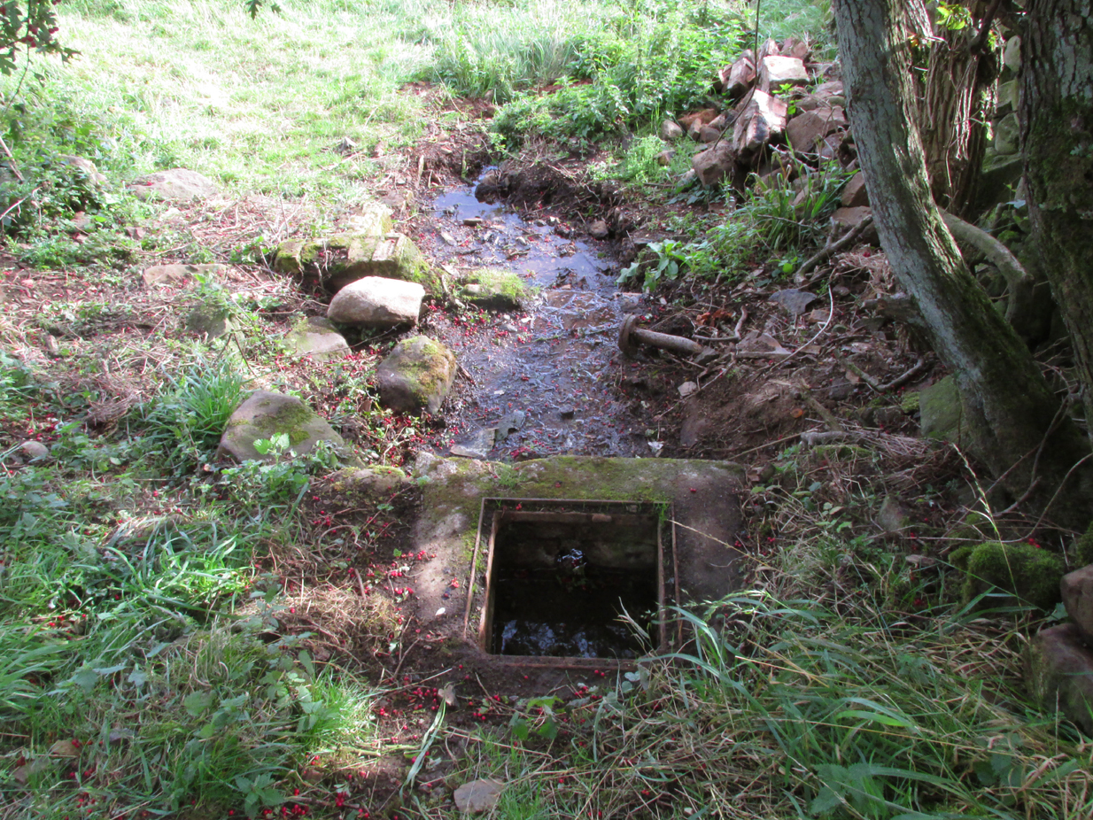
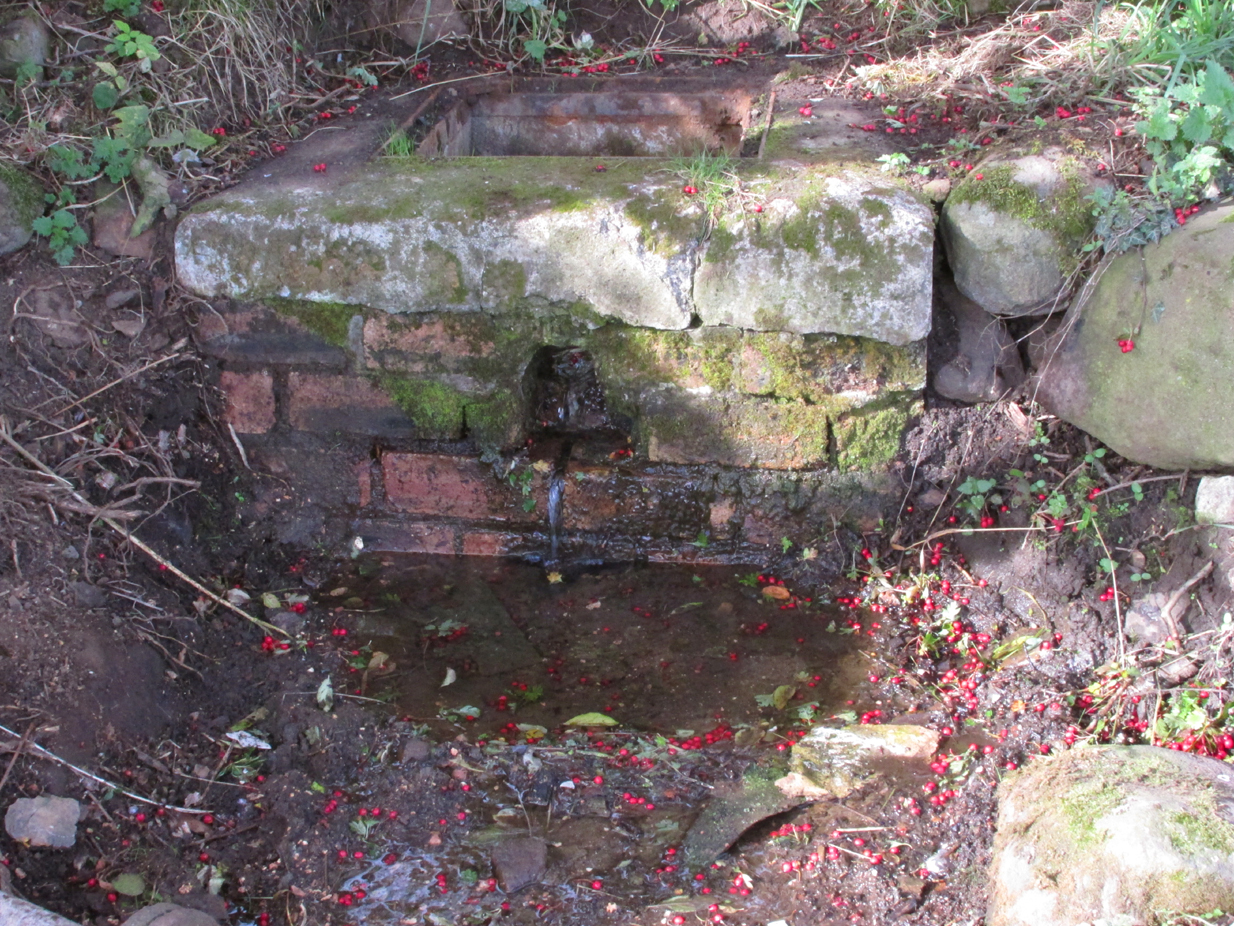
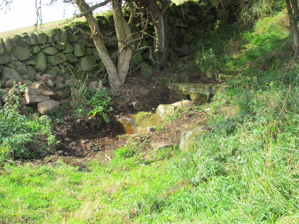
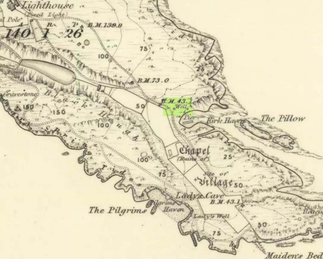
This seems to be the only ‘St John’ dedication on the Isle of May: a small island littered with more saint’s names, seemingly, than Iona and Lindisfarne combined! Illustrated on the 1855 OS-map, without name—and on the present-day large-scale OS-maps too, 20 yards or so from its 1855 position—the standard archaeo-historical records say nothing of the place. Thankfully antiquarian and folklore accounts have preserved evidence of its title. When the Victorian traveller Thomas Muir (1868; 1883) visited the Isle of May, he told how the islanders struggled to maintain a good water supply during a drought there in the 1860s. St. John’s Well was, he told,
“A pump standing by the path above Kirk Haven. The water good, but a little brackish. During all the drought of this summer we pumped water out of this well to supply our cattle.”
After Æ. J.G. Mackay’s (1896) visit to the island he told that here, along with the other holy wells on May,
“their brackish waters have lost the magic virtue they were credited with in early christian, possibly in pagan times.”
In more recent times it was described in W.J. Eggeling’s (1985) natural history survey. St. John’s Well was,
“the well within the high, cylindrical, whitewashed wall-surround lying across Haven Road from the Coal House. Also known as the Pump Well. It is a guiding mark for boats entering Kirk Haven.”
Folklore
St. John’s Day (June 24) was the christian name given to the traditional Midsummer Day, or days, around which good heathen festivals occurred; but we can find no ritual accounts of activity specific to this Well. Help!
References:
Dickson, John, Emeralds Chased in Gold; or, The Isles of the Forth, Oliphant: Edinburgh 1899.
Muir, Thomas S., The Isle of May – A Sketch, Edinburgh 1868.
Muir, Thomas S., Ecclesiological Notes on some of the Islands of Scotland, David Douglas: Edinburgh 1883.
Simpkins, John Ewart, Examples of Printed Folk-lore Concerning Fife, with some Notes on Clackmannan and Kinross-shires, Sidgwick & Jackson: London 1914.