Tammy Mill’s Well, Laurieston, Falkirk, Stirlingshire

Healing Well (lost):  OS Grid Reference – NS 910 790

Also Known as:

  1. Tammy Milns Well

Archaeology & History

This all-but-forgotten site situated somewhere on the north side of Lauriston was mentioned in Falkirk’s Notes & Queries (1906) journal, but its whereabouts is somewhat of a mystery (to me at least!).   In a series of question and answers about the site, the editor of the journal, James Love, told us:

“Mr Charles Brown, factor to the Marquis of Zetland, kindly informs us that on a late occasion there passed through his hands a copy of a feu contract by the Right Honorable Francis Lord Napier in favour of Alexander Cowie, brewer, at New Merchiston (now Laurieston), of a piece of ground lying to the north of Mary Street.  This is dated 7 August, 1762 and contains the following clause:  ‘Providing also that the said Alexr Cowie and his foresaid have the Liberty of the water of Tammy Milns Well in common with the said Lord Napier’s other vassals ay New Merchiston.'”

The well was mentioned again in 1781 with similar historical information.  As to the name of the well, Mr Love wrote,

“it would appear, from the circumstance, that an old infirm man belonging to the village, called Thomas Mills or Milns, used to sit with his wooden cup at the spring which flowed from the face of the hill, over which the present structure now stands, and served out to the weary passers-by the cooling and refreshing draught for any small pittance they in their generosity might think proper to give him.  After the lands of Lauriston passed into the hands of Sir Laurence Dundas, he took the advantage of such a copious supply of what then was pure water, and built the present reservoir over the spring, and had it conveyed to Kerse House by means of leaden pipes.”

But he fails to tell us what “the present structure” was that covered the well, nor the whereabouts of the “reservoir over the spring”; and as there’s no such feature on any of the Ordnance Survey maps at the time he wrote his article, nor beforehand, I remain puzzled as to its exact position.  This situation isn’t helped by the earlier description, which said it was found on “a piece of ground lying to the north of Mary Street”.  There are two wells literlly on the other side of Mary Street, but Kerse House meanwhile—whose water supply came from the well—is about 1½ miles to the north!  All in all there are more questions than answers here.  Added to this, in John Reid’s (2009) magnum opus on local place-names, the site is mentioned, albeit in passing, where he gives us the vague grid-reference of just NS 91 79, but this may just be educated guesswork on his part.  It would be good to know exactly where it was…

References:

  1. Love, James (ed.), “Tammy Mills (or Milns) Well, Laurieston”, in Local Antiquarian Notes & Queries, Falkirk – volume 1, 1906.
  2. Reid, John, The Place-Names of Falkirk and East Stirlingshire, Falkirk Local History Society 2009.

© Paul BennettThe Northern Antiquarian


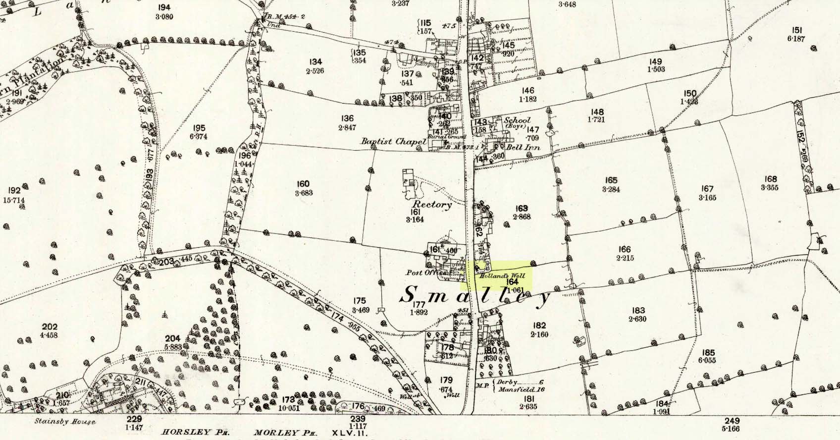
Holland’s Well, Smalley, Derbyshire

Healing Well:  OS Grid Reference – SK 4077 4436

Also Known as:  

  1. Holly Well

Archaeology & History

Hollands Well on 1881 map

Once visible near the middle of the village, references to this local water supply seem pretty scant.  According to Kenneth Cameron (1950) it gained its name from a local man called Robert Holland.  This may be the case; but there is a curious entry found in a notice regarding the Land Enclosures of Smalley from November 6, 1784.  In it we read that the land here was at that time owned by one Samuel Kerry (well known in the village as he built The Rose and Crown pub in 1768) who was living “upon the Common” and had “part of a croft” here.  Therein was mentioned a water source named the ‘Holly Well’ instead of the Holland Well.  I can only assume that the two are the same, as the proximity of them are very close indeed.  The account told that,

“a disused well in the triangular croft at the back of the sixth milestone in the village marks the site of (Samuel Kerry’s) original home, and he is said to have dug the “Holly Well” close by for brewing purposes, which has long supplied the vicinity with good water.”

The name ‘Holly’ may infer that a holly tree grew by the side of the well, and that the title ‘Holland’ was a corruption later grafted onto the site.  Are there any local historians out there who know more…?

References:

  1. Cameron, Kenneth, The Place-Names of Derbyshire – volume 2, Cambridge University Press 1950.
  2. Kerry, Charles, Smalley in the County of Derby, Bemrose: London 1905.

© Paul BennettThe Northern Antiquarian


Homer Well, Looe, Cornwall

Healing Well (lost):  OS Grid reference – SX 25 53

Archaeology & History

This curiously-named and long lost well would almost have us believe that the Greek poet and philosopher himself was a-wandering in this neck of the woods.  But that sadly wasn’t the case.  It seems to have been mentioned just once in Looe’s early Town Books:

“In 1621 that part of West Looe Down which lieth on the West part of the Homer Well, was let to rent, for two crops, at 6s.8d. per acre”

In Courtney & Couch’s (1880) Cornish dialect work, the word homer is said to mean “homeward”; this is also echoed in Wright’s (1905) magnum opus. It seems to imply that it was a drinking well used by folk traveling the short distance from Looe village, across the river and onto or over West Looe Down towards their cottage or farmhouse; akin to a refreshing resting place halfway home, so to speak.  Sometimes the word homeward can be taken to simply mean “at home,” in which case it would suggest that the Well was simply next to someone’s house.  We may never know…

References:

  1. Bond, Thomas, Topographical and Historical Sketches of the Boroughs of East and West Looe, J. Nichols: London 1823.
  2. Courtney M.A. & Couch, T.Q., Glossary of Words of Use in Cornwall, English Dialect Society: London 1880.
  3. Wright, Joseph, English Dialect Dictionary – volume 3, Henry Frowde: London 1905.

© Paul BennettThe Northern Antiquarian