Described by the early 20th century antiquarian and megalithomaniac Fred Coles (1903) as being situated “about 1¼ mile SE from the church at Ythan Wells,” all trace of this stone circle has long gone, and had already disappeared when Coles was surveying the region, telling merely that it had been here “in open fields.” All subsequent explorations looking for remains of the site has proven fruitless.
References:
Barnatt, John, Stone Circles of Britain – volume 2, British Archaeological Report: Oxford 1989.
Standing Stone (destroyed): OS Grid Reference – SP 257 282
Archaeology & History
We have found only one reference to this lost standing stone that could once be seen adjacent to the very well-preserved Chastleton Barrow Camp to the east of the village. In her scarce little work on the history of Chastleton House, Margaret Dickins (1900) told that,
“the oldest thing to be seen at Chastleton is the prehistoric stone, which till lately served as a field gate post on the Barrow Hill.”
This monolith was one in a series of megalithic sites in and around the village that have been destroyed due to the actions of ill-informed land-owners. In this case, the standing stone was in close association with the subsequent Iron Age encampment (this missing stone should not be confused with the nearby Goose Stones, greatly damaged).
References:
Bennett, P. & Chanter, James, The Complete Rollright Stones, forthcoming
Cross (destroyed): OS Grid Reference – TQ 3077 8093
Also Known as
Stone Cross of the Strand
Archaeology & History
First mentioned in Latin manuscripts from 1274 CE, the best description of this long lost monument, curiously, appears to be in Gover’s Place Names tome. In a slightly edited format he told us the following:
“There was a stone cross “without the bar of the New Temple” traditionally supposed to have been erected by William Rufus “in devotion to the Holy Cross and for the health of the souls of himself and his mother, Queen Maud… It was in the Strand, possibly on the site of the present church of St. Mary. It is referred to as crucem lap’ in 1274; la Crois de Piere in 1293; …Stonecrouch in 1337; crucem fractum in 1342…”
In subsequent notes Gover et al (1942) tell of a man they found in historical records to be Thomas le Barber, “described alternatively as being Thomas le Barber atte Stonecourche” in the Calendar of Rolls records of 1337, and again in the 1339 accounts.
Of the cross itself, information is minimal and scattered. It was destroyed several centuries ago but is mentioned in a number of old books on the history of the city. The historian Thomas Allen (1829), for example, told that
“opposite to Chester Inn stood an ancient cross. On this cross in the year 1294, the judges sat to administer justice, without the City.”
It was also a site where legal pleas for the county of Middlesex were to be held, at “the Stone Cross of lad Straund” as it was then known. Due to the early administrative function delivered from this cross, it strongly implies the place to have been a moot site prior to the erection of the cross, probably dating from the period in which tribal elders met here.
A Mr Newton tells in his London in the Olden Time that the top of the cross was damaged and knocked off by the crazy christians around the time of the Reformation and that for many years stood headless. When Vallance (1920) came to describe it, he told merely that,
“the Strand Cross, near Covent Garden. This cross was hexagonal on plan, and comprised four stages. It was standing in 1547, but was ultimately removed, its site being occupied by the Maypole, which was spoken of in 1700 as new.”
The Strand Cross would have been on the ancient ley (not one of those ‘energy lines’ invented by New Age fantasists) described first of all by Alfred Watkins (1925)—running from St. Martins-in-the-Field to St. Dunstan’s in Fleet Street—but he seems to have been unaware that the monolith ever existed. The alignment was subsequently described in more detail in Devereux & Thomson’s (1979) work on the same subject, but its existence seems to have evaded them too! Chris Street (2010) did include it in his much more detailed walk down the same ley. A maypole was also known to exist close to the site of the cross; with one account showing that the two monuments existed at the same time in 1543.
As the site seemed to have been an early moot spot, the Strand Cross may have been an omphalos in early popular culture (before the christians of course), or at the very least, a site of popular animistic tradition.
Cross (destroyed): OS Grid Reference – TQ 3180 8181
Archaeology & History
Site of Cow Cross on 1896 map
Not far from the long lost Fag Well could once be seen this old stone monument. Although not illustrated on the first Ordnance Survey maps of the inner city, it is highlighted on the 1896 edition (as shown here), just where Cow Cross Street meets Charterhouse Street—right by the boundary line—and is marked as ‘Site of Cow Cross’.
The cross gained its named from the cattle market that was held here from very early times, on the boundary of the lands of the Knights Hospitallers in the 12th century. Cattle itself–both horses and cows—were actually slaughtered at the market by the cross: a practice that has thankfully stopped (in public at least). Despite the place-name being referenced in many early accounts, actual descriptions of the cross are few and far between due to it being destroyed at quite an early date. When John Stow came to write his history of London in 1603, he told that it was no longer standing. Whether the cross replaced an earlier standing stone, we simply do not know…
References:
Gover, J.E.B., Mawer, Allen & Stenton, F.M., The Place-Names of Middlesex, Cambridge University Press 1942.
In truly that most unholy of places in England—Westminster, London—there was, in bygone times, a slightly more sacred site which, earlier still, might have been where a standing stone stood…. Might…. But such days are long gone down there. A gathering place of local people in very early times, the Broken Cross was, according to Vallance (1920),
“erected by the Earl of Gloucester in the reign of Henry III (1216-1272), but it did not stand very long. Its site is said to have been ‘the place of the meeting of the Folkmote…near St. Martin’s-le-Grand, about midway between the Northgate of the precinct (of St. Paul’s) and the church of St. Vedast.’ On 5th September 1379, agreements were drawn up for letting the stations about the Broken Cross to five divers persons. The cross was bodily taken down in 1390.”
Yet its name was maintained in street-names for many years later, simply as ‘Broken Cross’. Its position would have been very close to Cheapside.
George Gomme (1880) pointed out that such early folk moots were the development of tribal gatherings grafted from megalithic meetings onto early christian assemblies, pointing out how such assemblies for laws and councils were made at nearby St. Paul’s as early as 973 AD.
Settlement (destroyed): OS Grid Reference – TQ 932 733
Archaeology & History
An extensive site that was uncovered when a housing estate was being built on the south-side of Power Station Road at the end of the 20th century. During the Spring and Summer of 1998, the Canterbury Archaeological Trust began cutting trenches across the land and did some minor excavation work on the west side of the area, finding some traces of early human activity.
A second series of investigations was then undertaken by the Hertfordshire Archaeological Trust over the Autumn and Winter months of 1998-99, with the Kent Archaeological Rescue Unit then taking over for the rest of the year. Their team split the land into eight large sections and began a more detailed analysis and uncovered a huge number of finds. Amidst this, wrote Brian Philp (2002), there
“included an important collection of Bronze Age material, including large clay-weights, perforated baked-clay slabs and a good range of pottery types. Of special interest was the spinal bone of a large whale, perhaps washed up on the nearby shore.
“The picture now emerging is that of a substantial Bronze Age settlement site, spread across several acres and probably farming the adjacent land… It seems likely that three large ponds and…eight stone-lined pits were primarily for water-storage, both for watering cattle and for other agricultural or semi-industrial purposes… All this seemed to be happening about 900-400 BC on what still appears to be the largest Bronze Age settlement so far discovered on this important island.”
The archaeocentric place-name of Barrows Hill rises a mile to the southwest.
References:
Philp, Brian, Archaeology in the Front Line, KARU: Dover 2002.
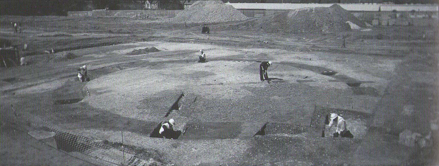
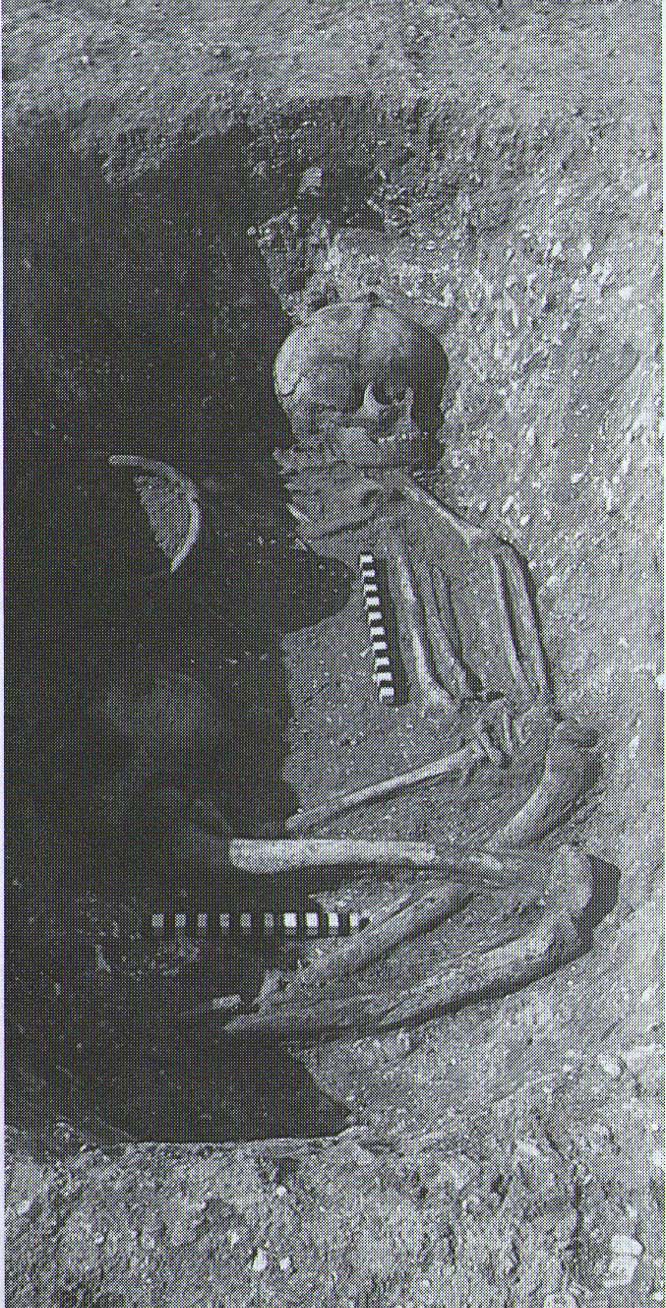
Tumulus (destroyed): OS Grid Reference – TR 389 661
Archaeology & History
A little-known site which archaeologist Brian Philp (2002) called “a Bronze Age barrow”. When the old Greyhound Stadium at Ramsgate was being demolished for a new housing estate, planning conditions required an archaeological evaluation and so Philps and his team set out to explore the area in February 2000. They weren’t to be disappointed! Unearthing a ring ditch nearly 20 yards (18m) across, they found that it had been cut into the local chalk some three feet deep. Although there was no obvious entrance, the northeast section of the ancient monument,
“was found to be covered by a compact layer of flint metalling. This was a wide and well-made surface or platform, perhaps of Iron Age date, which clearly covered the silted ring-ditch, Nearby was a large male skeleton in a very shallow grave and with head missing due to later disturbances.”
The excavated ring ditch (after Philp 2002)
The crouched skeleton (after Philp 2002)
But the best was yet to come! In another section of the circular monument, cut into the chalk itself, they found a complete male skeleton laid in typical foetus position, on its left side, with a large beaker pot positioned in front of it. These beakers are pretty common and tend to be seen as once holding food enabling the dead to eat in their journey into the Land of the Dead. It makes sense. The entire monument has since been completely destroyed.
References:
Philp, Brian, Archaeology in the Front Line, KARU: Dover 2002.
This settlement site was found thanks to the good work of the Bromley & West Kent Archaeology Group in the 1960s, when they decided to do follow-up work to what Brian Philp (2002) described as “doubtful sites reported mainly in the 19th century.” Time and again these “doubtful sites” at least turn into something of value — and such was the case here! The group commenced digging selective trenches in July 1964 in a small wooded area near to Baston Manor and they soon came across “a stratified deposit of late-Neolithic (2500 BC) pottery and flint.”
In successive returns to the site over two years, 5630 items—primarily fire-cracked stones, flints and more than 200 pieces of pottery, some of which was highly decorative—were unearthed and the site was recognised as an important settlement arena many thousands of years ago. In Kent, this was a rarity! Philps’ resumé of the site and its many remains told,
“Sometime about 2500 BC, a group of late-Stone Age farmers had selected this quiet hillside (now just in Hayes) to settle and live. Here they must have farmed small cultivated areas close to their huts and herded sheep and cattle to fresh areas and nearby streams. These were the first occupants of the West Wickham valley over 4000 years ago…”
On the east side of Warrengate Road, approached from Welham Green via Dixons Hill Road, or from Brookmans Park via Bradmore Lane.
Archaeology & History
1920 photo of the Public House. The Maypole is thought to have been in the grounds to the rear
The exact position of the pole is not marked on the 1896 25″ OS map, as it is probable that it had been removed by the middle of the nineteenth century (like the majority of the permanent Hertfordshire maypoles), but local belief in the 1950s and 60s was that it had been in the garden of the Old Maypole (originally known as ‘The Maypole’) public house, which adjoined the smithy in Warrengate Road, Water End. The public house is stated to have been built around 1520, with later additions, but is now a private house.
The population of Water End and nearby Welham Green was predominantly employed in agriculture, domestic service and straw plaiting, but the area’s proximity to London probably speeded the demise of the ancient traditions like maypole dancing .
The 1896 OS-map showing the grounds to the rear of the pub
Doris Jones-Baker writes: “The old Hertfordshire maypoles, on May Day decorated with ribbons and a bunch of spring flowers at the top, were described as being ‘as high as the mast of a vessel of a hundred tons, painted often in a diagonal or spiral pattern from bottom to top in yellow and black, or often in vertical stripes of red, white and blue’”
Interestingly, the rear of the public house garden adjoins the Swallow Holes, a geological feature where the intermittent flowing waters of the Mimmshall Brook disappear into the chalk in as many as 15 sink holes. Hertfordshire has an ancient tradition of ‘woe-waters’ related to the local geology, where the flowing or not of a stream or spring was seen to herald ‘sorrow to come’. From personal memory the Mimmshall Brook is normally a dry stream bed which can in winter suddenly turn into a raging torrent, flooding the land behind The Old Maypole. Any tradition of it having been a woe-water has though been lost. But it is just possible that long ago the coming of May Day was also seen to herald the end of flooding of the Mimmshall Brook and may explain the siting of the pole.
The last year that people danced is not recorded, but the local maypole tradition continued; this writer remembers ribbon dancing as a very small child to a fiddle accompaniment around a maypole erected at the nearby, but long demolished Waterend C.E. Primary School, which closed in 1960.
Folklore
As well as Maypole dancing, Hertfordshire had a rich tradition of May day ritual and song, which despite the county’s proximity to London, survived long enough for some of it to be recorded for posterity. While there does not seem to be any ritual recorded for North Mymms, the following was recorded at nearby Hatfield. “On may morning, dressed in white and holding bunches of Hawthorn or, in late seasons, blackthorn blossoms the children sang door to door a local version of the May song, which began:
‘A bunch of May I bring unto you
And at your door I stand,
Come pull out your purse,
You’ll be none the worse
And give the poor Mayers some money….’”
References:
North Mymms Local History Society, North MymmsPictures From The Past, Welham Green, 2002
Jones-Baker, Doris, The Folklore of Hertfordshire, B.T.Batsford, London, 1977
Kingsford, Peter, North Mymms People in Victorian Times, Brookmans Park, Hertfordshire, Privately Published, 1986
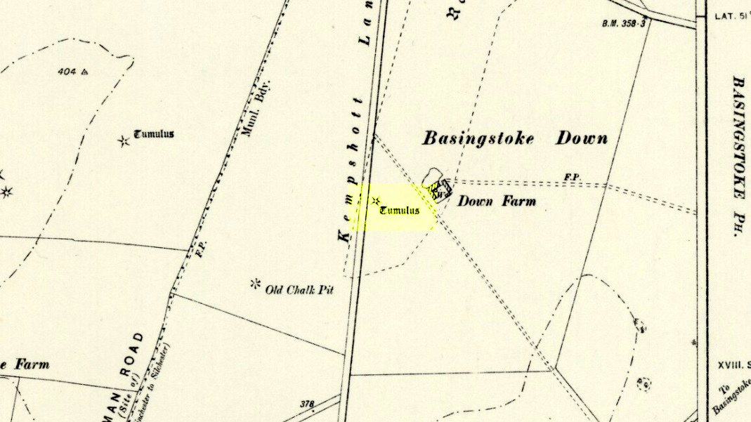
Barrow (destroyed): OS Grid Reference – SU 6018 5013
Archaeology & History
Downs Farm tumulus on 1897 map
On the western edges of Basingstoke, at Kempshott, could once be found this ancient site—destroyed many decades ago. It was one of number of similar prehistoric burial mounds in the area. First described in a listing of tumuli by Mr Andrews (1898) who told us that it was “oval” in shape, the monument was completely destroyed in 1939 and according to the Royal Commission (1979) lads,
“its site now lies beneath a house at the southwest corner of Kempshott Lane and Homesteads Lane.”
When the house where it once stood was being constructed, a collared urn was recovered from the tomb, which the Royal Commission thought indicated “that the monument (was) likely to have been of early Bronze Age date”—but obviously we cannot be sure. The site was listed in Leslie Grinsell’s (1979) extensive survey of prehistoric tombs in the area, in which he suggested it may have been a long barrow.
References:
Andrews, S., “A Short List of Some Tumuli in North Hampshire,” in Proceedings of the Hampshire Field Club & Archaeological Society, volume 4, 1898.
Grinsell, Leslie V., “Hampshire Barrows – part 3,” in Proceedings of the Hampshire Field Club & Archaeological Society, volume 14, 1940.
Royal Commission on Historic Monuments, England, Long Barrows in Hampshire and the Isle of Wight, HMSO: London 1979.
Willis, G.W., “Bronze Age Burials round Basingstoke,” in Proceedings of the Hampshire Field Club & Archaeological Society, volume 18, 1953.