Snowden Carr Carving (581), Askwith, North Yorkshire

Cup-and-Ring Stone:  OS Grid Reference – SE 17799 51005

Getting Here

Cowling’s 1937 sketch

Take the same direction as for cup-and-ring carving 582 from the Askwith Moor Road parking spot, walk up the road (north) 300 yards until you see the disused quarry on the moor to your right.  From here, head down onto the moor, straight down past the quarry for about 200 yards, angling slightly to your right.  You’ll notice some overgrown scattered mass of rocky ‘lumps’ in the heather — a cairnfield no less! — go just below these and watch out for some rocks emerging from the heather.  This carving (and its neighbours) is on one of ‘em!

Archaeology & History

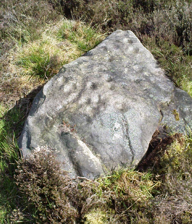
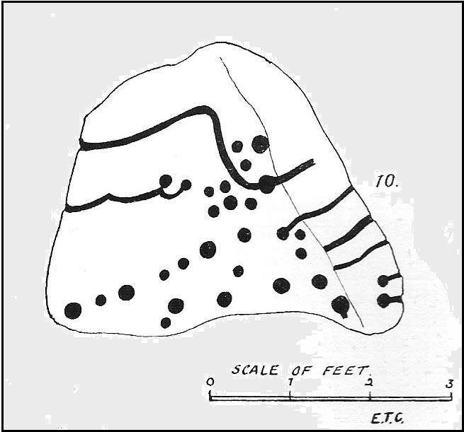
This impressive carving is one of a cluster of petroglyhs that are very close to each other, in the ruins of a cairn-field (though there’s some debate as to whether it’s medieval, prehistoric, or just quarry-spoil).  Peppered with many cups on the upper surface of the stone, we also have carved lines and cup-marks along the east-facing edge of the rock aswell.  I think it was Eric Cowling (1937) who was the first person to describe this stone (where he listed it as stone no.10 in his Otley survey), telling us that close to the Snowden Carr 582 carving,

“On the rise above No.9, is a cope-shaped boulder which is almost covered with cup markings and winding grooves.  One broad groove winds from the ridge, rising from a cup, and is continued to the margin.  Two cups are linked by a curve which is continued to the same edge.  The eastern side of the stone is almost upright and bears two cups with grooves running to ground level.”

Due to the similarities in design on this stone and that of carving no.618 in Fewston valley bottom a half-mile away, Cowling thought that it likely that the same person did both carvings.  Well….y’ never know!

References:

  1. Boughey, Keith & Vickerman, E.A., Prehistoric Rock Art of the West Riding, WYAS 2003.
  2. Cowling, Eric T., “Cup and Ring Markings to the North of Otley,” in Yorkshire Archaeological Journal, volume 33, 1937.
  3. Cowling, Eric T., Rombald’s Way: A Prehistory of Mid-Wharfedale, William Walker: Otley 1946.

© Paul Bennett, The Northern Antiquarian


Snowden Crags Necropolis, Askwith Moor, North Yorkshire

Cairnfield:  OS Grid Reference – SE 176 514

Also Known as:

  1. Snowden Moor Cairnfield

Getting Here

From the Askwith Moor Road parking spot and walk up the road for about 500 yards an head to your right (east) onto he moor, above the rocky ridge known as Snowden Crags.  After 100 yards or so of walking through the heather, the entire cairnfield is under your very feet!  If the heather’s grown, you probably won’t see a thing.

Archaeology & History

First described in Eric Cowling Rombald’s Way (1946), where he mentions around 30 cairns on the moorland plain immediately west of the Snowden Moor settlement. These were plainly visible when Richard Stroud and I visited here in 2005, thanks mainly to the fact that the heather had been burnt away.  Once it’s grown back, virtually all of these tombs will be hard to find.  I first had fortune to see some of these tombs on a visit here with Graeme Chappell about 15 years ago, but only a little of the cemetery was then visible.  Following another visit to the site this week, a great deal more has become visible, thanks again to heather-burning on the moors.

One of around 30 cairns on the ridge
…and another one!

Curiously omitted from the Nidderdale Archaeological survey report of sites in this region (anyone know why?), the cemetery itself stretches from the western edge of the Snowden Moor settlement, several hundred yards west along the flat moorland plain towards the moorland road, stopping a short distance before the line of old grouse butts.  It is highly likely that some of the stones in the grouse-butts originated in some of the prehistoric cairns along the ridge.  And if summat aint done about it, there’s a likelihood this could easily happen again in the near future.

…and another!

The easternmost cairn touches the very edge of the D-shaped settlement; and another of them is right next to a cup-marked stone.  Whilst a number of the cairns along this ridge are much like those found on the moors above Ilkley, Bingley, Middleton, Askwith Moor, Earby, etc — averaging 2-3 yards in diameter and less than 2 feet high amidst the peat and decaying herbage — one notable feature to many of these tombs is the inclusion of a rather large, singular boulder, against which or around are propped the smaller stones, typical of cairns found elsewhere in the region.  This ‘large boulder’ characteristic is not common at other tombs in the mid-Pennines, but seems specific to this graveyard.   Neither do the large boulders seem set in any particularly consistent fashion.  There is the possibility that they were originally above the smaller cairn of stones, but this is purely hypothetical and non-verifiable without excavations.

The important Snowden Crags cairn circle, discovered by the hardworking Keighley volunteer Michala Potts on Thursday, 20 May, 2010, can be found on the northern part of this cairnfield.

References:

Cowling, Eric T., Rombald’s Way: A Prehistory of Mid-Wharfedale, William Walker: Otley 1946.

© Paul Bennett, The Northern Antiquarian


Weston Churchyard, Askwith, North Yorkshire

Cup-and-Ring Stone:  OS Grid Reference – SE 1774 4663

Also Known as:

  1. Carving no.568

Getting Here

Dead easy this. From Otley, take the north road over the River Wharfe and turn left following the signs to Askwith, where you’ll hit Weston village first. Once here, take the small left turn down to Weston Hall and the accompanying church. Go into the churchyard and check the graves!

Archaeology & History

This is a real curiosity.  It’s found in the graveyard of All Saints church, Weston, where one of the graves has several small stones on it, with this small stone with the following cup-and-ring designs upon it.  A plaque has been attached to it as a memorial to one ‘Susan Mary Dawson’.  Strange…

Sid Jackson’s 1958 sketch
Cup-marked stone deliberately placed on a christian grave

It was first written about by Sidney Jackson (1957), but where it first came from and why it has been placed here in a christian setting is something of a mystery.  It’s also odd inasmuch as although we know that there was some form of  ritual or geomantic use of cup-and-rings in relation to neolithic and Bronze Age burials — that such a tradition has been performed by this particular family on this grave.  It is obviously highly unlikely that this family had any knowledge whatsoever of burial traditions in relation to cup-and-ring art (please, shoot me down in flames if you know otherwise), so this re-use of this prehistoric stone is likely to be little other than fortuitous. But then, the occult history of some of the influential families in and around this region in relation to witchcraft, ancient kingship and esoteric practices, might indicate otherwise…

Does anyone know anything about the Dawson family history which might throw light on this modern use of a prehistoric tomb marker?  It has all the hallmarks of once coming from a prehistoric cairn, but we know little of its history prior to 1957.

References:

  1. Boughey, Keith & Vickerman, E.A., Prehistoric Rock Art of the West Riding, WYAS 2003.
  2. Jackson, Sidney, ‘Cup-and-Ring Boulder, Weston Churchyard,’ in Cartwright Hall Archaeology Group Bulletin, 2:16, 1957.

© Paul Bennett, The Northern Antiquarian


Old Man of Snowden, Askwith, North Yorkshire

Standing Stone (destroyed?):  OS Grid Reference – SE 1765 5032

Archaeology & History

Eric Cowling (1946) described this lost or destroyed stone as “a squat standing stone at junction of the Askwith bridge-path with the Otley-Timble highway, saying how it gave its name to Stoop Hill, “which it surmounts.” But in several ambles here in search of this old stone, we’ve yet to locate it; though we did find the Stoup Hill cup-marking and possible neighbour on the southern edge of the hilltop.

Folklore

In days of olde, the ‘Old Man’ was the fabled companion of the legendary ‘Old Woman,’ or great cailleach (the christian cult stupidly, somehow, turned this mythic figure into their ‘devil’ – to which it has no relationship whatsoever).  Although no specific folktale remains here, the name of this lost stone tells that it had some mythic tale underscoring it; perhaps simply that it marked the burial of some forgotten chief or elder.

References:

  1. Bennett, Paul, The Old Stones of Elmet, Capall Bann: Chieveley 2001.
  2. Cowling, E.T., Rombald’s Way: A Prehistory of Mid-Wharfedale, William Walker: Otley 1946.

© Paul Bennett, The Northern Antiquarian


Snowden Carr Carving (600), Askwith Moor, North Yorkshire

Cup-Marked Stone:  OS Grid Reference – SE 17987 51162

Also Known as:

  1. Coped Stone

Getting Here

Follow the same directions as to reach the Tree of Life Stone carving.  From here walk 7 or 8 yards east.  You can’t miss it!

Archaeology & History

Coped Stone carving (after Boughey & Vickerman)

About 20 feet away from the more renowned Tree of Life Stone — and seemingly linked to it by a small stretch of ancient walling that runs between the respective stones — is this rather large boulder close to the walling with at least seven cup-marks on it.  A number of vague lines run down and around the edges of some of the cups, but they can be somewhat hard to see if the light conditions aint right (I don’t recommend trying to suss it out on dark grey overcast days — unless you’ve got awesome eyes!).  Immediately next to this rock is a large collection of small stones, looking to be the remains of some man-made construction from time past.  The nature of this pile of rocks has yet to be ascertained, but it would be reasonable to assume that it was at one point earlier a much larger pile that has been plundered for use to make the drystone walls hereby.  Less than 10 yards below this and the Tree of Life Stone carving is a line of ancient walling, at least Iron Age in nature, possibly earlier, running for some distance east-west up and across the moorland.

Cup-marks near top of the stone

The carving was described for the first time, albeit very briefly, by Eric Cowling (1937) in his lengthier description of the Tree of Life Stone, saying how “a small coped stone to the east has several scattered cups” on its surface — meaning this old thing!  Boughey & Vickerman’s (2003) survey (2003) describe it as a “medium-sized, upstanding, worn rock.  Seven or eight possible cups, mostly at the top of S face, but one at its bottom of E face.”

…And the poor old fella has had nowt else said of it until now!  I reckon this carving will only be of interest to the most serious of meditators or hardened rock-art freaks!

References:

  1. Boughey, Keith & Vickerman, E.A., Prehistoric Rock Art of the West Riding, WYAS 2003.
  2. Cowling, Eric T., “Cup and Ring Markings to the North of Otley,” in Yorkshire Archaeological Journal, part 131, 33:3, 1937.
  3. Cowling, Eric T., Rombald’s Way: A Prehistory of Mid-Wharfedale, William Walker: Otley 1946.

© Paul Bennett, The Northern Antiquarian


Todholes, Weston, Lanarkshire

Standing Stone (destroyed): OS Grid Reference – NT 038 456

Archaeology & History

This standing stone used to be positioned on the old boundary line between the Carnwatch and Dunsyre parishes.  It might be a good idea to check out the perambulation records to see if owt went off here, before its destruction.  About five-feet tall, it was positioned on a small rise in the ground, 500 yards south of Todholes.

References:

  1. Royal Commission on the Ancient & Historical Monuments of Scotland, Lanarkshire: Prehistoric and Roman Monuments, HMSO: Edinburgh 1978.

© Paul BennettThe Northern Antiquarian 


Greystone Allotment, Weston, North Yorkshire

Cup-and-Ring Stone:  OS Grid Reference – SE 18433 49648

Also Known as:

  1. Carving no.541 (Boughey & Vickerman)
  2. Greystone Rock

Getting Here

Although cited as being on Weston Moor, it is closer to Askwith village. From the village, take the north road and shortly before reaching the T-junction, park-up (somewhere!). There’s a small copse of trees on your right and fields above them – that’s where you’re heading. You might have to bimble about a bit before the rock catches your attention, but it’s worth the wandering.  Look around!

Archaeology & History

Sketch of the design c.1985

This is an excellent, archetypal cup-and-ring stone that’ll be loved by any real rock art student!  Cups-and-multiple rings are the main visual feature to this stone, along with another 20 single cups and another primary cup-and-ring, all on a medium-sized sloping rock face.  The carving was first described by Cowling & Hartley (1937).  Since their initial discovery, several other writers have mentioned it with little further comment.  The smaller but impressive double cup-and-ring carving 543 can be seen at the bottom left of the woodland in front of you – well worth seeing if you’re visiting here!

References:

  1. Boughey, Keith & Vickerman, E.A., Prehistoric Rock Art of the West Riding, West Yorkshire Archaeology Service 2003.
  2. Cowling, Eric T., Rombald’s Way, William Walker: Otley 1946.
  3. Cowling, E.T. & Hartley, ‘Cup-and-Ring Markings to the North of Otley,’ in Yorkshire Archaeological Journal, 33, 1937.
  4. Hotham, John Paul, Halos and Horizons, Hotham Publishing: Leeds 2021.

© Paul Bennett, The Northern Antiquarian