Not too difficult to locate if you don’t mind wandering to and fro in deep heather. From the Askwith Moor Road parking spot, walk up the road (north) 300 yards until you see the disused quarry on the moor to your right. From here, head onto the moor, straight down past the quarry for about 200 yards, angling slightly to your right. You’ll notice some overgrown ‘lumps’ in the heather — deemed as a cairnfield by archaeologists — go just below these and watch out for some rocks emerging from the heather. This carving (and its neighbours) is on one of ’em!
Archaeology & History
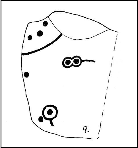
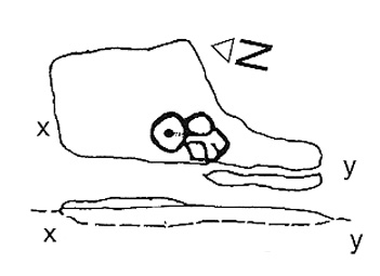
This curiously-shaped large rock has several worn cup-and-rings on its upper surface, with several cup-marks aswell. Two deeply etched lines running down the edge of the rock have also been pecked away as part of the carving, in contrast to the distinguishing natural water-worn line that runs diagonally along and down to the bottom of the stone.
The site was first described by Eric Cowling (1937), who labelled it as Carving no.9 in his survey, saying:
Carving 582, looking SWCarving from above
“At the eastern and lower end of the barrow group on Snowden Carr is a cluster of angular boulders, one of which has several markings cut on the upper surface. There is a cup and ring on the highest, and alongside two rings are joined together and enclose separate cups. One corner of the area is isolated by a groove running from edge to edge, and within this enclosure are three cups.”
Catalogued as ‘stone 582’ in Boughey & Vickerman’s (2003) survey, their description of the carving was one with “fourteen possible cups, several with indications of a ring, some of which intersect; grooves.”
References:
Boughey, Keith & Vickerman, E.A., Prehistoric Rock Art of the West Riding, WYAS 2003.
Cowling, Eric T., “Cup and Ring Markings to the North of Otley,” in Yorkshire Archaeological Journal, part 131, 33:3, 1937.
Cowling, Eric T., Rombald’s Way: A Prehistory of Mid-Wharfedale, William Walker: Otley 1946.
From the Askwith Moor car-park, walk down the road (south) for 2-300 yards until you reach the gate on the right-hand side of the road. Go thru this and turn immediately left, following the fence along, parallel to the road for about 100 yards (if you reach the small disused quarry, you’ve gone 100 yards too far), then walk into the heath, up near the top of the little peak and walk down the other side of the slope for about 80 yards. You’re getting damn close — look around!
Archaeology & History
First found on the afternoon of May 13, 2010, in the company of Dave Hazell — though at the time the light was poor and the sky was grey and overcast, not allowing for any decent images being made. We returned here yesterday under a lovely clear sky for most of the day (and without the polluting roars of planes from the nearby airport, thanks to that great Icelandic volcano [keep it going!], making it even better) and got some decent photos this time.
Sketch of basic designClose-up of some cups
It’s only a small low stone, slightly sloping (similar in size and form to carving no.535 about 100 yards west of here), and is gonna be very difficult to find when the heather is in full growth. But thankfully when we found it last week, the heather had been burnt back. Whilst there are two large and very notable cups here — one on the west-facing vertical edge of the stone, the other on its south-facing slope — several others are more troublesome to see clearly, both through a mixture of age and erosion. The other cups are a little smaller aswell, being very similar in status to the curious small cup-markings on the Lattice Stone carving (no.481). One cluster of these smaller cups are arranged in a curved T-shape formation around the middle to eastern-side of the rock. Below this are what seems to be a long singular cup, but upon feeling this — the Beckensall technique — the hardworking Keighley volunteer Michala Potts found it seemed to consist of three small cups all linked to each other. Attached to this section, a small groove runs up to the aforementioned T-formation cluster. Whilst at the top-end of the stone is what seems to be another larger cup-marking, but I’m not sure whether it’s Nature’s handiwork, or artificial. A few more visits here might enable us to say one way or the other!
There are no other archaeological remains immediately adjacent. Another “possible” cup-marked rock (more than twice the size of this stone) can be found about 30 yards further uphill, next to another large stone. But one of the nice things about this small carving is its position in the landscape: an excellent view opens up of mid-Wharfedale below you, and the uphills of Rombald’s Moor is on the far side of the valley. Make of it what you will…
References:
Boughey, Keith & Vickerman, E.A., Prehistoric Rock Art of the West Riding, WYAS 2003.
Dead easy this. From Otley, take the north road over the River Wharfe and turn left following the signs to Askwith, where you’ll hit Weston village first. Once here, take the small left turn down to Weston Hall and the accompanying church. Go into the churchyard and check the graves!
Archaeology & History
This is a real curiosity. It’s found in the graveyard of All Saints church, Weston, where one of the graves has several small stones on it, with this small stone with the following cup-and-ring designs upon it. A plaque has been attached to it as a memorial to one ‘Susan Mary Dawson’. Strange…
Sid Jackson’s 1958 sketchCup-marked stone deliberately placed on a christian grave
It was first written about by Sidney Jackson (1957), but where it first came from and why it has been placed here in a christian setting is something of a mystery. It’s also odd inasmuch as although we know that there was some form of ritual or geomantic use of cup-and-rings in relation to neolithic and Bronze Age burials — that such a tradition has been performed by this particular family on this grave. It is obviously highly unlikely that this family had any knowledge whatsoever of burial traditions in relation to cup-and-ring art (please, shoot me down in flames if you know otherwise), so this re-use of this prehistoric stone is likely to be little other than fortuitous. But then, the occult history of some of the influential families in and around this region in relation to witchcraft, ancient kingship and esoteric practices, might indicate otherwise…
Does anyone know anything about the Dawson family history which might throw light on this modern use of a prehistoric tomb marker? It has all the hallmarks of once coming from a prehistoric cairn, but we know little of its history prior to 1957.
References:
Boughey, Keith & Vickerman, E.A., Prehistoric Rock Art of the West Riding, WYAS 2003.
Jackson, Sidney, ‘Cup-and-Ring Boulder, Weston Churchyard,’ in Cartwright Hall Archaeology Group Bulletin, 2:16, 1957.
Very troublesome to locate when the heather’s deep. To get here take the Askwith Moor Road heading north and park-up at the big gritted parking spot halfway along. Cross the road (west) and walk up a little and onto the moorland track. When you hit the triangulation pillar, walk down (left) onto the moor, heading for the small rise in the land a few hundred yards away. Once there, start walking down its sloping south-face, watching for any evidence after 100 yards. Be vigilant!
Archaeology & History
One of 4 hut circles in very good state of preservation
This small settlement was first found on 18 July, 2004, when a small group of us, in search of the troublesome Man Stone carving, were lucky to be on the moors shortly after the heather had been burnt back, amidst this archaeologically rich area of Askwith Moor, on the northern end of Hollin Tree Hill.
There were at least four hut circles found here (on the right of the track as you walk up the slope), with one in particular — the northernmost of the group — in a very good state of preservation. This particular circle measured approximately 20 feet in diameter, with an entrance to the south side. It is marked by a low earthfast boulder on the northeast side, visible even when the heather is deep.
Although we counted four such circles, it’s very likely that an intensive search would uncover more remains on this hillside. In revisiting this site in October 2016, the heather had grown back over the entire complex and the circles were very difficult to see; but we were able to discern the one on the very top of the hill (the one in the photo). The other hut circles, lower down the slopes, were notable only by zigzagging back and forth until we walked onto loose walling.
From the Askwith Moor dusty parking spot, walk up the road for 160 yards where, on each side of the road, you’ll see a straight line running across the moors. On the left-side (west) walk onto the moor for 50-60 yards along this line, then dead straight west into the heather for another 50-60 yards and look around. It’s hard to see if the heather’s grown.
Archaeology & History
Found by Richard Stroud on July 20, 2004, this single hut circle is in faint evidence. About twenty feet across with a section of the low walling either missing, or more probably buried in the peat. Although no other hut-circles were immediately visible, this was probably because of the excessive heather-growth. I have little doubt that others will be close to this one, as the area is littered with prehistoric sites. The petroglyph catalogued as Askwith Moor 529 is very close to this hut circle.
Take the same directions as to reach the Snowden Crags Necropolis, and where the small rounded hill rises up on the eastern end of the plain, look around and you’ll find the stone in question.
Archaeology & History
Up near the edge of the Snowden Moor settlement, just a few yards away from Carving-570, is this medium-sized earthfast boulder with what seems to be three or four cup-markings on its western-face. Boughey & Vickerman (2003) describe the stone as with a “deep gully, cups and enlarged cup, perhaps weathered carving but could be natural” — which seems a reasonable assessment. Certainly the cups seem weathered, although a couple of them may have been man-made. At the side of the rock are the remains of a small cairn, and it is positioned next to the beginning of the Snowden Moor Cemetery.
References:
Boughey, Keith & Vickerman, E.A., Prehistoric Rock Art of the West Riding, WYAS 2003.
Cowling, Eric T., Rombald’s Way: A Prehistory of Mid-Wharfedale, William Walker: Otley 1946.
Follow the directions to reach the Snowden Moor settlement and, from the Upper D-shaped enclosure (at SE 1782 5131) walk west up the sloped hillock 30 yards west and, on its top, head to its northern edge where a small cairn can be found. The carving is next to it.
Archaeology & History
Very close to what seems to be the boundary between the Snowden Moor Settlement and its adjacent Cemetery is this small earthfast rock with three cup-markings on it, two of which may be linked by a small line. I have to say that we have to be cautious about the veracity of this carving. By the side of this stone is what seems to be the remains of a cairn.
References:
Boughey, Keith & Vickerman, E.A., Prehistoric Rock Art of the West Riding, WYAS: Wakefield 2003.
Follow the same directions as to reach the Tree of Life Stone carving. From here walk 7 or 8 yards east. You can’t miss it!
Archaeology & History
Coped Stone carving (after Boughey & Vickerman)
About 20 feet away from the more renowned Tree of Life Stone — and seemingly linked to it by a small stretch of ancient walling that runs between the respective stones — is this rather large boulder close to the walling with at least seven cup-marks on it. A number of vague lines run down and around the edges of some of the cups, but they can be somewhat hard to see if the light conditions aint right (I don’t recommend trying to suss it out on dark grey overcast days — unless you’ve got awesome eyes!). Immediately next to this rock is a large collection of small stones, looking to be the remains of some man-made construction from time past. The nature of this pile of rocks has yet to be ascertained, but it would be reasonable to assume that it was at one point earlier a much larger pile that has been plundered for use to make the drystone walls hereby. Less than 10 yards below this and the Tree of Life Stone carving is a line of ancient walling, at least Iron Age in nature, possibly earlier, running for some distance east-west up and across the moorland.
Cup-marks near top of the stone
The carving was described for the first time, albeit very briefly, by Eric Cowling (1937) in his lengthier description of the Tree of Life Stone, saying how “a small coped stone to the east has several scattered cups” on its surface — meaning this old thing! Boughey & Vickerman’s (2003) survey (2003) describe it as a “medium-sized, upstanding, worn rock. Seven or eight possible cups, mostly at the top of S face, but one at its bottom of E face.”
…And the poor old fella has had nowt else said of it until now! I reckon this carving will only be of interest to the most serious of meditators or hardened rock-art freaks!
References:
Boughey, Keith & Vickerman, E.A., Prehistoric Rock Art of the West Riding, WYAS 2003.
Cowling, Eric T., “Cup and Ring Markings to the North of Otley,” in Yorkshire Archaeological Journal, part 131, 33:3, 1937.
Cowling, Eric T., Rombald’s Way: A Prehistory of Mid-Wharfedale, William Walker: Otley 1946.
Takes a bit of finding this – but if you like your rock art, it’s worth the search! You can follow directions for the getting to the Man Stone then, when you reach it, look to the near horizon to the east. Get to the bottom of the sloping hillside where a large rounded boulder sits and walk up the slope about 10 yards. Look around here cos you’re very close.
Woman Stone carvingCarving highlighted in chalk
Alternatively, from the Askwith Moor Road, follow the path to the triangulation pillar on Shooting House Hill. Keep going for another 100 yards and check a small path to your left (south). Follow this down until you get to the top of the slope. Go to the bottom of the slope and look around!
This carving is best checked out in winter and early spring: if you go here in summer & autumn there’s bracken covering the entire site & you’ll never find it!
Archaeology & History
Drawing by Inmaculada Ibanez-Sanchez
This stone was first discovered by Graeme Chappell and I during one of our many ambling explorations here in the early 1990s and was first mentioned in my Old Stones of Elmet (pp.149-152). Marija Gimbutas would have loved this seemingly matriarchal-looking cup-and-ring carving, suggestive of many Mother Goddess images she found across Europe – hence its title!
Woman Stone design (after Boughey & Vickerman)
I don’t think that the old-school archaeological types would lower themselves to say such a thing, but as I aint one of them I’m quite confident in saying that this carving does seem to be a pictorial representation of a female figure: one of the earliest of its kind in the British Isles? (check its nearby male compatriot, the Man Stone – a distinctly human figure and one of the earliest of its kind in the British Isles) Very close by we are left with old place-name remnants pointing directly at the presence of pre-christian goddess remains in the mythic landscape – an issue I’ll expand on in the near future.
In the survey by more recent rock art students Boughey & Vickerman (2003), their illustration of the carving makes it look even more like an early female figure! (though I hear they don’t like people giving the carvings names – unless, of course, one of them lot names it…)
References:
Bennett, Paul, The Old Stones of Elmet, Capall Bann: Milverton 2001.
Boughey, Keith & Vickerman, E.A., Prehistoric Rock Art of the West Riding, WYAS: Wakefield 2003.
Gimbutas, Marija, The Language of the Goddess, Harper-Collins: San Francisco 1989.
Gimbutas, Marija, The Civilization of the Goddess: The World of Old Europe, Harper-Collins: San Franciscoo 1991.
Follow the same directions to reach the Tree of Life Stone, then walk up the well-worn footpath up the slope for about 100 yards and, as you get to near the top of the hill, just watch out for a large-ish stone on the right. That’s it!
Archaeology & History
First described by Eric Cowling 1937, here we have what here looks like a faded cup-and-ring plus at least eight other cup-markings near Snowden Crags (though Boughey & Vickerman [2003] counted only 6 cups here). In more recent years it has become known as the “Fence Stone” due to its proximity the straight line of fencing which ran across the moor hereby. Cowling’s description of the site told:
Faded cup-and-ringCowling’s 1937 drawing
“The spur of hill separating Snowden Carr from Snowden Craggs is surmounted by a D-shaped enclosure which has a small level area in the highest corner. Here, on a triangular table stone amongst the heather, is a well-cut cup, ring and radial groove running to the margin of the surface. Four other cups appear to have no definite arrangement.”
He went onto say that “many of the boulders which surround this table are marked with cups.” They are indeed!
References:
Boughey, Keith & Vickerman, E.A., Prehistoric Rock Art of the West Riding, WYAS 2003.
Cowling, Eric T., “Cup and Ring Markings to the North of Otley,” in Yorkshire Archaeological Journal, part 131, 33:3, 1937.
Cowling, Eric T., Rombald’s Way: A Prehistory of Mid-Wharfedale, William Walker: Otley 1946.
Acknowledgements: A huge thanks to James Elkington for use of his photo for this site profile.


")


")