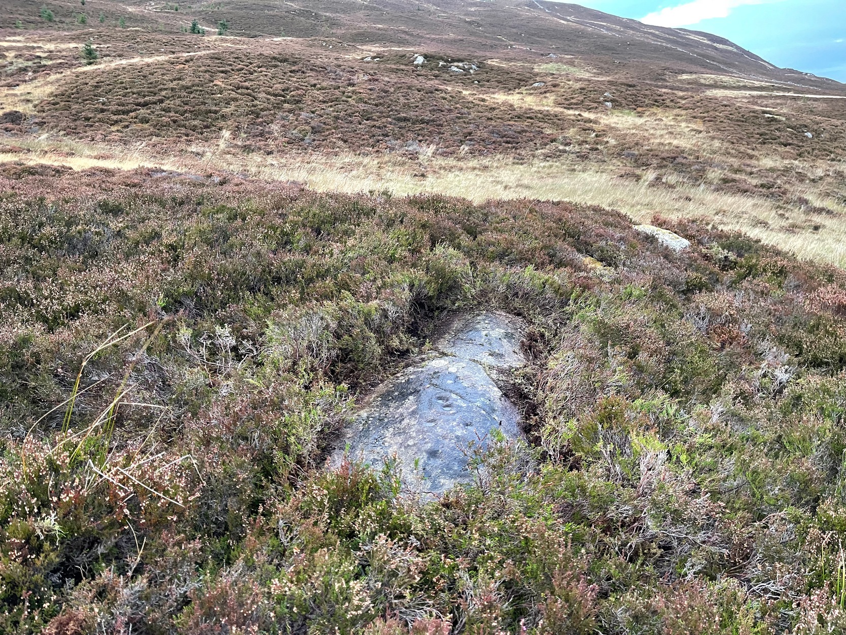
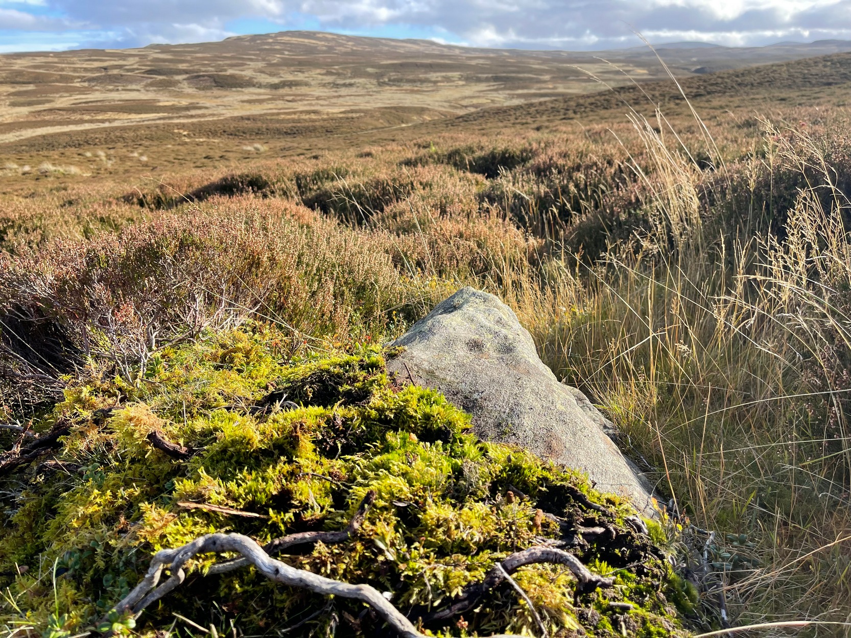
Like many of the Craig Hill carvings, this takes some finding when the heather’s deep… If you can locate the Craig Hill hut circle (there are actually several of them close to each other), face uphill (looking at the trees) and then from the hut circle walk diagonally to your right (northeast) and walk up the slope for 30-40 yards. A large boulder is in front of you and, just past it at the edge of a small rock-face, a fallen tree is your marker. Just a few yards above and past this is an earthfast elongated stretch of rock. You’ll find it…
Archaeology & History
Some cups & 2-in-a-ring
On my visit to this carving I arrived near the end of the day. Within the hour, beneath an already cloudy grey sky, night had fallen; and so, obviously, my assessment of this carvings design was somewhat hampered…
It’s one of several quite separate petroglyphs that almost collide with each other on adjacent rock faces. Etched across this, an elongated slightly convex stone, we find a series of cup-marks in no particular order, mainly running along the topmost section of the stone. Others fall away at the edges, with what seemed like one or two at the more northeastern end of the stone. However, due to the poor lighting when I came here, I struggled to make out the full design and so probably missed some important elements. I’ll update this if/when I visit it again – or if a fellow antiquarian visits the spot and sends in some good images.
From Kenmore village, just as you’re going out of the village towards Aberfeldy (A827 road), turn right as if you’re going on the minor road on the south-side of Loch Tay. Almost immediately on this road, turn left and take the tiny, steep road uphill towards Amulree. After 2½ miles uphill, the road begins to level out and a small loch is on your left (north). Just past it, on the same side, a track runs onto the moors. Walk along here for nearly a mile where the track splits: keep to your left and the track follows the line of walling. Now’s the hard bit: after literally ⅔-mile, walk downhill and cross the burn (stream), then less than 50 yards up the slope on the other side, zigzag around…
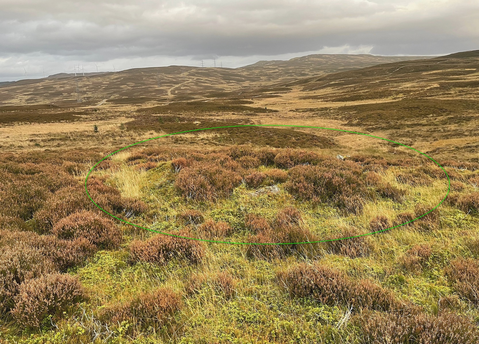
Archaeology & History
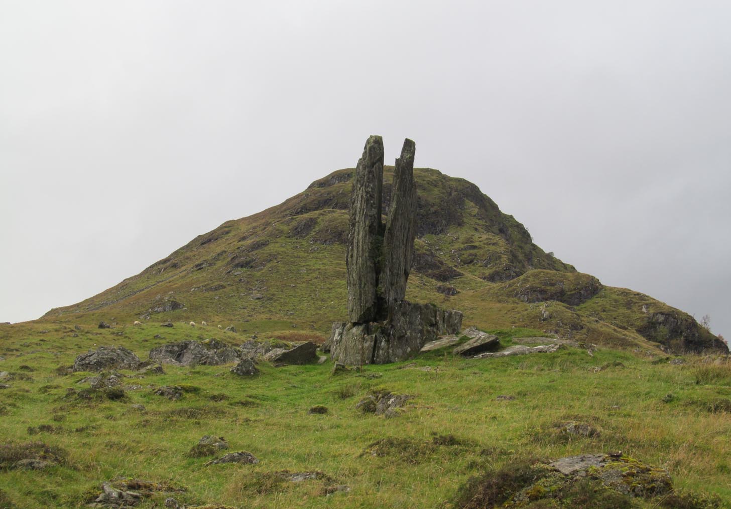
Craig Hill circle looking SW
Overlooking a small (unnamed) burn immediately to the right and a large wide marshy hollow to the front, is this small and seemingly singular hut circle, in a good state of preservation, surrounded by the scattered mass of cup-and-ring stones—some complex, some very plain—all over this moorland slope. It’s a very long journey to take just to visit a single hut circle, but I’d assume that you’d be wanting to see the petroglyphs surrounding it too—so mebbe have a look at this whilst you’re fondling the rock art!
Internally this is quite a small circle, measuring barely 5 yards (east-west) by 6 yards (north-south), seemingly with its entrance on the north. Its small size suggests it was constructed for the use of just one person; two at the very most. The structure is still in very good condition considering its age (possibly Bronze Age), with minimal damage apart from Nature’s wind and weathering. The circle is made up primarily of a number of large rocks with many filling stones, with the walling being a yard or so wide all round. In all likelihood, the rest of the building would have been made of timber, with a typical tented roof. It’s an excellent spot to base yourself to explore all the cup-and-ring stones on these slopes. Perhaps, just perhaps, this might have been a shaman’s hut, looking over the ancestral images on the rocks hereby…. ♥
Take the long steep zigzag road from Kenmore to Amulree, and just where the road begins to level out, park up near the isolated hut by the roadside at the side of the lochan. Just past here, a track on your left takes you onto the moors, past the lochan. Nearly a mile along the track splits: bear to the right, uphill slightly, then it’ll wind downhill and you’ll pass another track on your right. Ignore it, keep walking along and where you find a grassy little passing-place on your right—stop! Now walk uphill, onto the moor, through the heather for 175 yards and the land has levelled out. Look around!
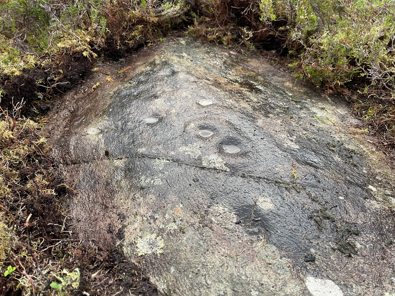
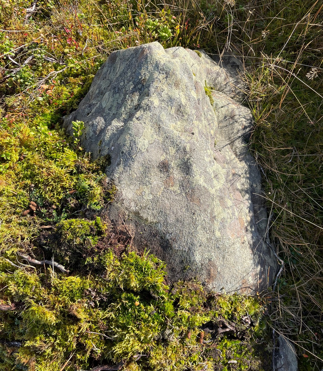
Archaeology & History
Cupmarks from above
I came across this very basic carving when checking out a couple of others close by and found that it hadn’t been recorded before. It’s nothing special to look at, but is an outlier of the main Craig Hill cluster of carvings a few hundred yards to the west. The design consists of at least two cup-marks that have been etched near the top of the rock, although when I wet the stone it seemed as if a third one was next to the other two, as if in a line. The sun was at its peak when I found it, which meant that I couldn’t get any decent photographs to illustrate this—even when I watered the olde thing! It’s another carving that will only be of interest to the real petroglyph fanatics amongst you.
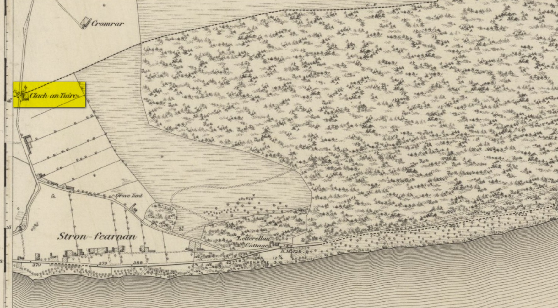
Pretty easy to find unless the vegetation takes over! From Fearnan take the road to Fortingall. Just as you’re going out of Fearnan, in the walling by the very last house on the right-hand side of the road is this large earthfast boulder. Y’ can’t miss it!
Archaeology & History
I first visited the Clach an Tuirc – or the Boar’s Stone – in 1981 when I stayed at Fearnan for a few weeks and, after clambering on top, looked down on the several simple cupmarks. Forty years later, I returned with a camera!
First highlighted on the 1862 OS-map, Fred Coles (1910) made a brief note of the petroglyph in one of his megalithic surveys, but only noticed a single cup, saying:
“Near Cromraor, close to the cottage at Clash na Tuirc, stands the large boulder bearing that name, the Boar Stone. Its highest point is about six feet above the road, and bears one very distinct cup-mark.”
But there are several cup-markings on top of the stone, just as William Gillies (1938) described.
Folklore
Not far from here tradition tells of a legendary figure who is known today only as the Lady of Lawers (whom tradition asserts to have been a member of the Stewart family, from Appin, Argyll – they of the daemonic Red Book of Appin). She made various prophecies, one of which said “that when Clach an Tuirc, the Boar’s Stone at Fearnan, would topple over, a strange heir would come to Balloch.” Though as the stone still aint toppled, we’re still waiting… (let’s just hope this doesn’t augur more of those selfish tories into our mountains who bring with them their mantras of “gerrof mah land”)
References:
Coles, Fred, “Report on Stone Circles Surveyed in Perthshire (Aberfeldy District),” in Proceedings Society Antiquaries, Scotland, volume 44, 1910.
Gillies, William A., In Famed Breadalbane, Munro Press: Perth 1938.
MacMillan, Hugh, ‘Notice of Two Boulders having Rain-Filled Cavities on the Shores of Loch Tay, Formerly Associated with the Cure of Disease,’ in PSAS 18, 1884. ???
Yellowlees, Walter, Cupmarked Stones in Strathtay, Scotland Magazine: Edinburgh 2004.
Acknowledgements: Huge thanks for use of the 1st edition OS-map in this site profile, Reproduced with the kind permission of the National Library of Scotland.
Clach na Sgoltadh, Glen Lyon (photo – Lisa Samson)
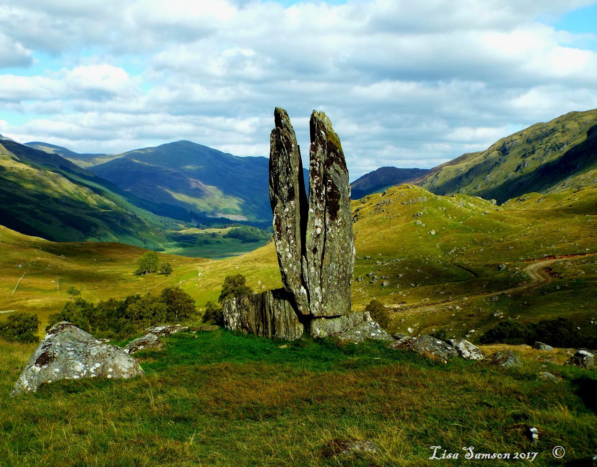
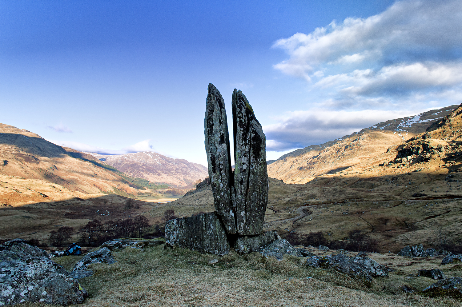
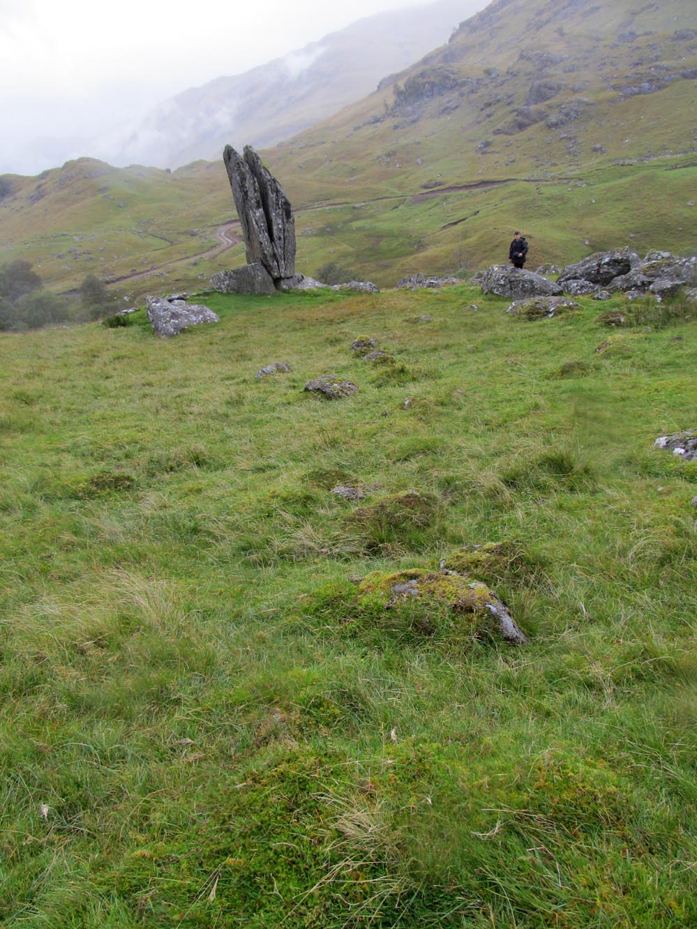
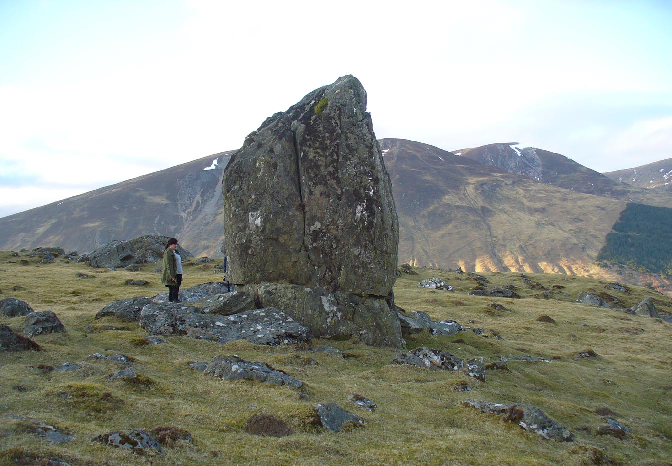
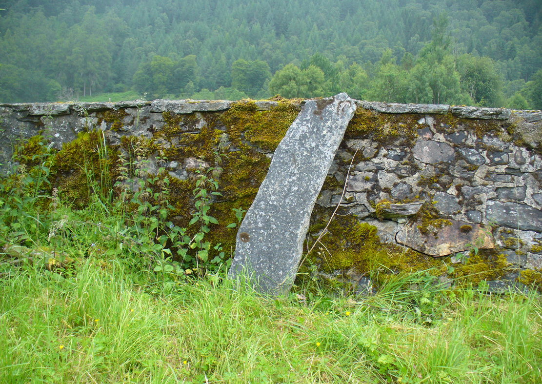
From Fortingall take the road into the legendary Glen Lyon. About 8 miles along, a short distance past the Adamnan’s Cross standing stone, you reach the tiny hamlet of Camusvrachan. On your left is a singular dirt-track, past some cottages. Go along here and over the river bridge until you reach the junction on the other side. From here, turn right and a half-mile on when you reach the farm and manor-house on your right, park up. From here you’ll see a track going uphill. Walk straight up and after a half-mile or so, keep your eyes peeled to your right. You cannot fail to see this impressive giant on the slopes above you!
Archaeology & History
This is a truly mighty monolith! — a beauty no less! Standing upon a rocky ridge nearly halfway along the glen, the landscape it looks across is, without doubt, some of the finest in the British Isles. To our ancestors who, until just two hundred years ago peopled this and nearby glens in great numbers, this great stone would have been well known and had old myths told of it. Today we have only bare fragments.
To give an ‘archaeological survey’ of any kind to this site would seem somewhat of an anathema, as it is generally deemed to be little other than one of Nature’s incredible creations. We’ll come to that in a minute. But what is quite certain is that a line of very old and very low-lying walling runs from up the slope and almost straight down to Clach na Sgoltadh. You can see it pretty clearly in the photograph below. The walling stops at the giant stone and continues no further downhill from the other side of the giant upright.
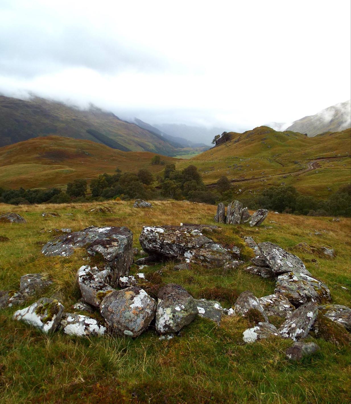
Walk diagonally down the slope about 30 yards south-east from the stone and you’ll find a small but distinctly man-made ring of stones, low to the ground, with an entrance on its northeastern side. It’s somewhat of a puzzle as it’s too small for a hut circle (I laid down in it in various ways and found you’d have to lie foetal all night if you were to use it as your own little abode), and it equally too small as an animal pen – unless it was for just one animal, which is most unlikely. The small circular construction wouldn’t seem to be prehistoric, but it would be good to know what it is.
So, we do have some very slight archaeological association with the site, albeit minimal, with the very ancient walling that leads to the stone being the most intriguing.
Small stone ‘hut’Low line of walling
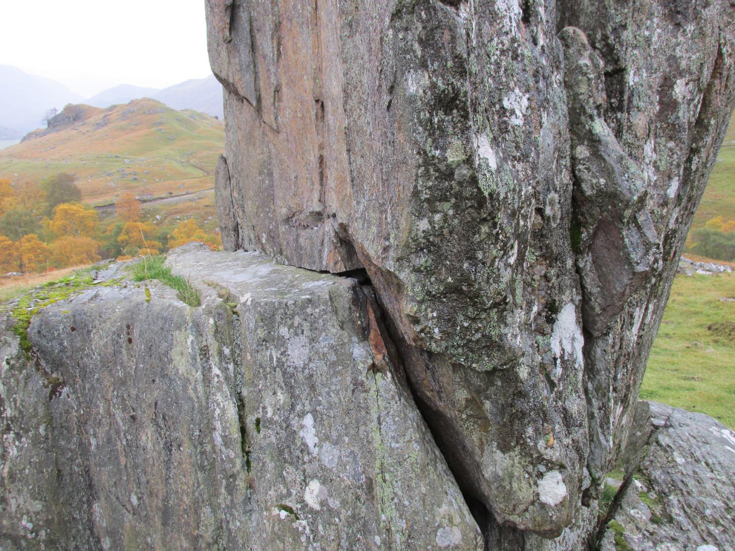
The stone is generally attributed to be a geological creation. I certainly cannot say, as I have no expertise in the subject. However, in the opinion of just about everyone with whom I’ve visited this stone, I seem to be the only one who doesn’t think it’s man-made. A number of people have each insisted to me that it’s been stood upright by humans due to the quite distinct ‘squaring’ of the upright stone, particularly at the north-facing base. —and been seemingly bemused at my own lack of conviction. It does look as if it could have been cut and squared just as they all say but, let me repeat, I’m no expert at geology, and so all I can say is that I simply don’t know one way or the other. (useless prick that I am!)
“Perhaps a stone mason might know?” someone suggested—which seemed to be a good idea. Certainly a stone mason would surely be able to tell if it had been cut and dressed at the base, where it fits into the large earthfast rock….
Cue Chris Swales: a reputable stone mason from near Skipton, North Yorkshire. Chris and his friends took a week long whistle-stop tour in and around the Loch Tay region and thought they’d visit Glen Lyon. I heard about this and so asked him if he’d have the time to visit this stone giant and, if possible, let us know his opinion: is is a natural obelisk, or does it look to have been erected by humans? I told him my opinion and that of the geologists who give it an entirely natural provenance.
It was a few weeks later when he got back in touch and I asked him if he’d been up to Clach na Sgoltadh.
“I did,” he said. “it’s bloody impressive Paul. And what a gorgeous landscape too. I’d love to go there again.”
“Aye, it is Chris. And what did you think of the giant stone then? In your opinion is it man-made or natural?”
“Well I don’t know for certain Paul,” he said, “but in my opinion I’m 95% sure that it’s man-made.” He said it plain as day, just like a typical daan-to-Earth Yorkshireman. Chris isn’t into any the energy ley-line stuff, so his words carry more weight than those who wanna spice-up a site by projecting their own beliefs onto a place. As a result, I was somewhat taken aback by his words.
“What—are you sure Chris?!” I asked.
Cut & dressed stone?
“Like I said – I’m not 100% sure Paul. I can’t really say it 100% – but I’m 95% certain that people cut and dressed the base of that stone and put it there. If it’s natural, then I’d like to know how they think that’s the case. I’m willing to be shown otherwise, but in my opinion, on the whole, it’s man-made. People stuck that stone there!”
It would be great to get another stone mason’s opinion about this site; and it would definitely be good to read a geological viewpoint, but I’m not aware of any papers regarding this stone. (does anyone know of any?) For my part: I can only reiterate that I’m ‘unsure’ whether or not this is man-made. I’m simply not qualified to give an objective opinion.
The curious thing is: if this isNature’s handiwork, then it would have been held in greater reverence to our ancestors than if it had been erected by people. Impressive creations of Nature were always deemed to be inhabited by genius loci of truly archaic potency. And in these deep impressive mountains, where the names of nature spirits still abound, this—without doubt!—would have been a place of considerable awe and sanctity. May it remain as such…
Folklore
Looking to the west immediately uphill and behind Clach na Sgoltadh is the rising rounded hill of Creag nan Eildeag. Legend has it that the great Celtic hero Fionn stood atop of this crag and fired one of his arrows at the stone, splitting it in half and leaving the stone as we see it today.
In a small cleft in the stone, quartz deposits can be seen along with an effigy of the Virgin Mary. However, the title of the Praying Hands of Mary is a modern attribution and has no historical or mythic veracity.
References:
Stewart, Alexander, A Highland Parish; or, The History of Fortingall, Alex MacLaren: Glasgow 1928.
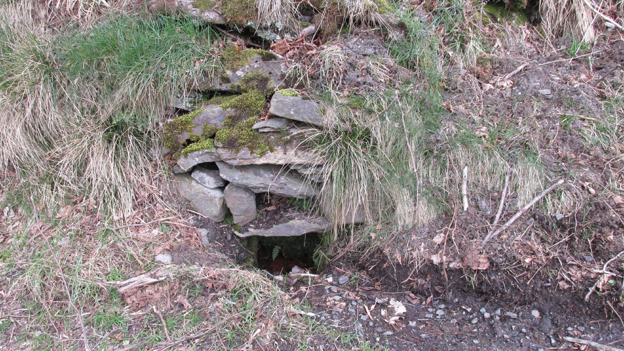
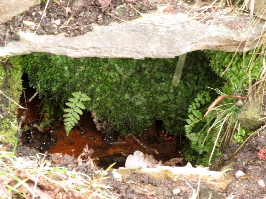
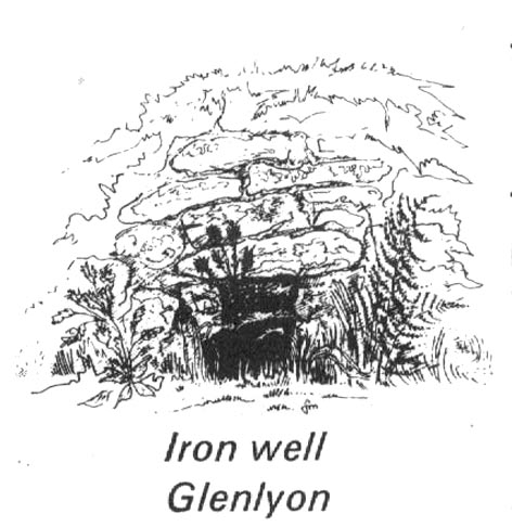
From Fortingall village, head west and turn down into the incredible beauty that is Glen Lyon. As you enter the trees, a half-mile along you pass the small gorge of MacGregor’s Leap in the river below. 2-300 yards pass this, keep your eyes peeled for an old small overgrown walled structure on the left-hand side of the road, barely above the road itself. A large tree grows up above the tiny walled enclosure, within which are the unclear waters that trickle gently….
Archaeology & History
In previous centuries, this all-but-forgotten spring of water wasn’t just a medicinal spring, but was one of the countless sites where sympathetic magick was practised. The old Highlanders would have had a name for the spirit residing at these waters, but it seems to have been lost. The site is described in Alexander Stewart’s (1928) magnum opus on this stunning glen, where he wrote:
“Still a few yards more and Glenlyon’s famous mineral wishing well is seen gushing up, surrounded by its wall of rough stones now sadly in need of repair. It has a stone shelf to receive the offerings of those who still retain a trace of superstition or like to uphold old customs as they partake of its waters. The offerings usually consist of small pebbles, but occasionally something more valuable is found among them. The roadmen may clear that shelf as often as they like, but it is seldom empty for long.”
A local lady from Killin told us that she remembers the stone above the well still having offerings left on it 20-30 years ago. Hilary Wheater (1981) sketched it and called it the Iron Well.
Close-up of the waters (photo by Paul Hornby)Hilary Wheater’s sketch
The waters in this small roadside well-house actually emerge some 50 yards up the steep hillside (recently deforested) and in parts have that distinct oily surface that typifies chalybeates, or iron-bearing springs – which this site is an example of. Its medicinal properties would help to people with anaemia; to heal women just after childbirth; to aid those who’d been injured and lost blood; as well as to fortify the blood and stimulate the system.
Across the road from the well, Stewart (1928) told of a giant lime tree that was long known to be the meeting place for lovers (perhaps relating to the well?), and the name of the River Lyon here is the Poll-a-Chlaidheamh, or ‘the pool of the sword’, whose history and folklore fell prey to the ethnic cleansing of the english.
References:
Stewart, Alexander, A Highland Parish, Alexander Maclaren: Glasgow 1928.
Wheater, Hilary, Aberfeldy to Glenlyon, Appin Publications: Aberfeldy 1981.
In a discussion about the ancient chapel to St. Eonan (the local name in these parts for Adamnan) that once existed near the Bridge of Balgie in Glen Lyon, the local historian Duncan Campbell (1886) informed us that,
“St. Eonan built his chapel near the only stone circle in Glenlyon. The stones of this circle have been removed within my memory. The place is called Clachaig.”
The same writer (Campbell 1888) later told how its remains were still visible around 1848 CE. Campbell’s (1910) later memoirs also mentioned his childhood recollections when the stone circle was in situ, telling that the
“place above the churchyard to Clachaig, named so, the Place of Stones, (was) because the old Druidic stone circle was there.”
We don’t know exactly where the megalithic ring stood; and although modern analysts think the site may have been underneath the invading forestry commission plantation, local lore puts it closer to the graveyard above Kerrowmore.
Enhanced image of curious near-circular form close by
A local dowser thinks that the upright slab in the graveyard at Kerrowmore may be the one remaining stone left here after the circle’s destruction. A quick meander back and forth on a rainy day here, on the geological ridge at the back (south) of Kerrowmore, found only a curious near-circular earthwork that might have been the original site, but it may be fortuitous. A nearby rock outcrop known as “Coill a’ Bhaird” may have been related to the circle.
Folklore
A local man (thanks Tom) said how tradition tells that some of the stones from this circle were taken and used in making the drive to Meggernie Castle last century.
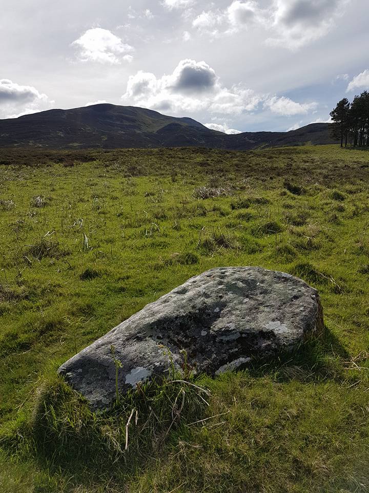
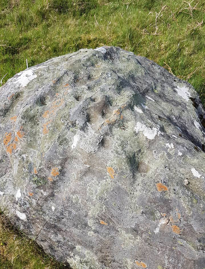
If you take the path up to Schiehallion (the great hill of the faeries) from the car park near the Braes of Foss, just a hundred yards or so past the first set of trees onto the moorland, keep your eyes peeled for the long stone on your right, a few yards off the path. Upon its upper elongated surface you’ll notice a series of cup-markings etched onto it, oh so long ago now…
Close-up of cups (photo by Michelle Allan)
Located below the legendary Schiehallion, or Mountain of the Faeries, this carving is best visited over the winter and spring months (before the bracken encroaches). On its upper surface there are about 25 cup-marks, many of them pecked to about an inch deep, with one of them being more than 6 inches across and 2 inches deep. Weathering over the ages has effected them. It seems to have been rediscovered in the early 1970s and is, officially speaking, an isolated carving; this is most unlikely—and needs the keen eyes of fellow antiquarians to find others in this beautiful neighbourhood.
Acknowledgements: Massive thanks to Michelle Allan for allowing us to use her photos of the Leachd Nam Braoileag carving in this site profile.
Get to Pubil at the top of Glen Lyon, then walk on the track on the north side of Loch Lyon. Several miles along you turn up Glen Meurain. When you reach the crossing of the stream, follow the waters up Allt Meurain for about 3-400 yards until you find a small flat section of marshland right by the streamside. You’ll notice rocky undulations of human remains here, and a distinct small cairn of rocks near the top of this section. Have a good rest here (and I’d advise avoiding the place in the summer months).
Archaeology & History
Remote indeed is this small cairn—less than 3 feet high and 4 feet across—sitting by the burn-side in a place many miles from any human habitation. It is found amidst a small cluster of other archaeological remains close to each other, as if indicating a settlement of sorts, abandoned probably around the time of the Highland Clearances. Although it is highlighted on modern OS-maps in antiquated lettering, the cairn here looks like it is only a few centuries old. A larger mass of rubble stone is found adjacent to the small pile of rocks, from which it may originally have been taken. Without archaeological analysis we will not know for certain the real age of this old tomb.
MacRee’s Cairn & adjacent rubble
Folklore
The small grassy hillside immediately across the trout stream here is known as Sith Trom’aidh – the Sad Fairy mound, whose history appears to have been lost. Alexander Stewart (1928) told that this cairn was the burial place of one of Colin Campbell’s dairymaids, found and slain here during a skirmish with cattle raiders in the 16th century.
References:
Stewart, Alexander, A Highland Parish; or, The History of Fortingall, Alex MacLaren & Sons: Glasgow 1928.
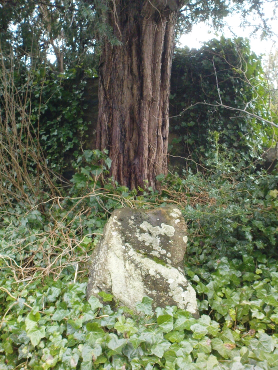
Go into the Fortingall churchyard, turning left through the gates (walking across in front of the enclosed sacred yew tree), towards the dip in the walling past the graves. Go over this wall, turning left and through another small gate. Immediately through the gate, note the small upright stone on your right, below an offspring of the old yew tree. That’s the spot!
Archaeology & History
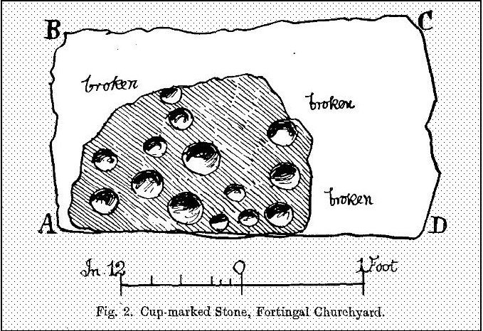
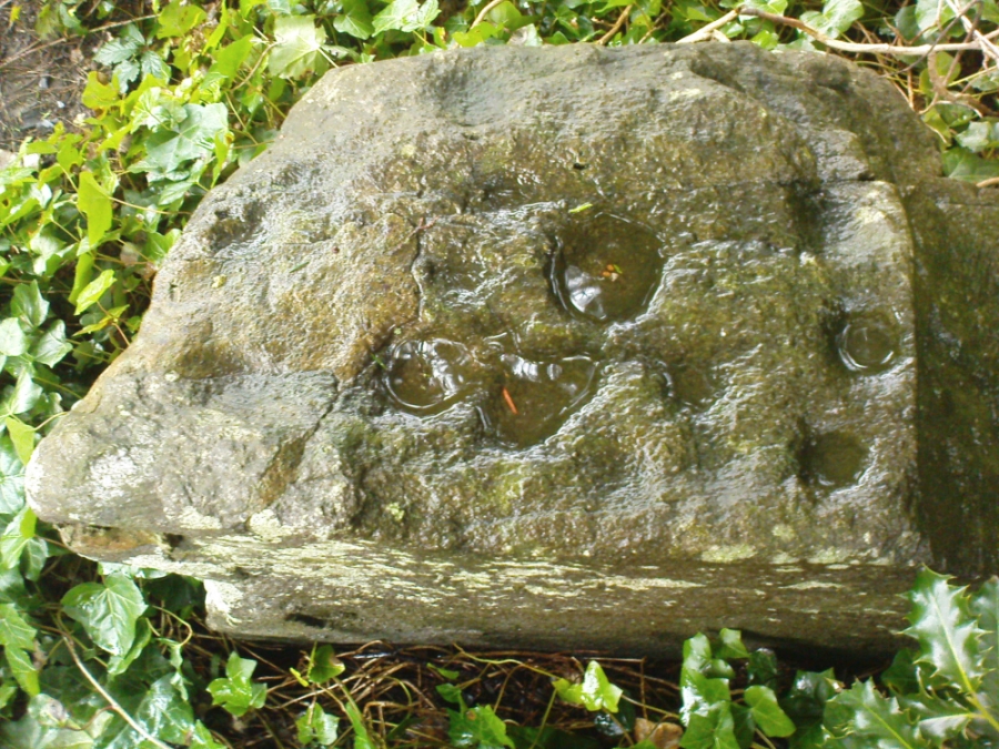
In the legendary churchyard at Fortingall — home to remains from a panoply of beliefs — below the sacred yew tree we find the remains of this hewn piece of stone, recovered from the Earth beneath the roots of the old tree more than 100 years ago. Upon its crown we see a cluster of cup-markings: Fred Coles (1910) counted 14, I counted 13, the Ordnance Survey boys counted 9, and other surveyors are somewhere in between.
Fred Cole’s sketch of the stonePhoto of the cup-markings
Described and illustrated in the Strathtay rock art survey of Sonia Yellowlees (2004), it seems that the earliest mention of the stone was by our Perthshire megalith hunter Fred Coles (1910). When he wrote about it, the site had only recently been rediscovered. He told that he was,
“informed by Rev. W. Camphell, minister of the parish, that in 1903, when some alterations were being made in that portion of the burying-ground belonging to the late Sir Donald Currie of Garth, the workmen came upon this Stone lying at a depth of 8 feet, at a point not many feet distant from the stem of the famous Yew-tree. Noticing the cup-marks on the Stone, the workmen raised it and set it up erect on the site it now occupies, close to the western wall of the Garth burial-ground — about 25 feet from the spot where it was unearthed: In the plan annexed (fig.2) the oblong bounded by the letters A B C D shows the dimensions of the base, and the small cup-marked surface, evidently much broken, and 2 feet 10 inches above ground, shows all that now remains of the work of the prehistoric artificer. There are no rings or grooves, and the cups, except for clearness and neatness of finish, do not present any special features.”
…and another angle.
Mr Coles then made some intriguing suggestive remarks regarding the position of the carving beneath the ancient yew tree (which to those of you who aren’t aware, is believed to be the oldest yew tree in Europe and has a pagan altar next to it), wondering whether the animistic tradition of the tree had anything to do with the carving itself. It would certainly make sense. But there is also the possibility that the carving was brought from elsewhere and placed by the tree at a later date. We simply don’t know.