From Askwith village go up the Moor Lane and at the crossroads go straight across, down and along Snowden Carr Road until the road levels out and, watch carefully, for a small crag of rocks in the fields above on your left. Keep a keen eye out for the gate into the field immediately below these rock, right by the roadside (it’s easily missed). This carving is the first rock on your right 10 yards through the gate.
Archaeology & History
Cup-marks on CR613
This relatively large, two-tier rock, has simple cup-markings on the topmost level of the stone: thirteen of them according to Boughey & Vickerman (2003). We looked at this last week, in poor daylight and were unable to ascertain how many cups were on the stone; and again yesterday when the conditions were excellent, and found there are at least fifteen cups carved on the rock. However, we didn’t really give this stone too much attention (bad of us, I know) as the calling of the adjacent Naked Jogger carving was sticking out demanding our attention!
References:
Boughey, Keith & Vickerman, E.A., Prehistoric Rock Art of the West Riding, WYAS 2003.
Start at the Askwith Moor parking spot on Askwith Moor Road, then walk down the road (south) 300 yards till you reach the gate and track on the other side of the road, heading southeast. Following the track onto the moor and take the footpath on your right after 75 yards. Follow this along until you hit the gate & fence. Climb over this, then follow the same fence along (left) and down, and keep following the fence and walling all the way on until you reach the very bottom southwestern edge of Askwith Moor itself. Now, walk up the slope to your right and, near the top of this rise 200 yards or so away are 2 or 3 rocks close to each other. You’re here!
Archaeology & History
On the small, unnamed hill at the very far southwestern edge of Askwith Moor, within the unrecorded Lower Lanshaw enclosure is this previously unrecorded cup-marked stone that has been found thanks to further heather burning operations hereby. But it’s nowt much to shout about if you’re after big colourful designs. This is merely one of the many single cup-marked rocks scattering the Yorkshire uplands. The large pecked cup, nearly 2 inches in diameter, is found on the lower eastern end of a long, sloping stone. Along the same ridge are also faint remains of ancient walling.
A very faint cup-and-ring stone can be found just over the brow of the hill from here, about 30 yards northeast (at SE 16059 50875) in the northeastern edge of the Bronze Age enclosure walling.
Follow the directions to reach cup-and-ring Carving 581 and this small stone is about 10 yards above it, up the slight slope amidst the heather. You might have to look around a bit though, as it’s a small flat stone and gets easily overgrown.
Archaeology & History
Broken cup-and-ring stone
Founds amidst a cluster of what Eric Cowling called “a barrow group,” or a cluster of cairns, is this excellent little carved stone, with a number of cup-and-rings close to what is now the northern edge of the rock. But this small stone has blatantly been split off from a larger piece (perhaps split in half), but a brief scramble in the heather here couldn’t locate the other part of the stone — which is a great pity. For although we have four or five cup-and-rings linking onto each other, where the stone has been split, one of the cups has been cut away and it seems obvious that there was more carved onto the other lost section of the stone — wherever it may be! There is the possibility that this stone was thrown down from a nearby cairn and was broken in the course of its movement; but we might only find this after the heather’s been burnt back in the near future. Anyway, Boughey & Vickerman (2003) discerned this as a
“small square rock with smooth level surface. Six cups, five with incomplete rings and some running into one and other.”
It’s a good one (despite what my poor photos may infer) and well worth a look at if you’re into your rock art!
References:
Boughey, Keith & Vickerman, E.A., Prehistoric Rock Art of the West Riding, WYAS 2003.
Cowling, Eric T., Rombald’s Way: A Prehistory of Mid-Wharfedale, William Walker: Otley 1946.
From Askwith village go up the Moor Lane and at the crossroads go straight across (Snowden Moor is to your left). Go down and along Snowden Carr Road until the road levels out and, watch carefully, about 500 yards on from the crossroads on your left you’ll see a small crag of rocks in the fields above. Stop and go through the gate walking up the field. At the top is a gate: go thru this and turn right, up the footpath for 100 yards, keeping your eyes peeled! You’re damn close!
Archaeology & History
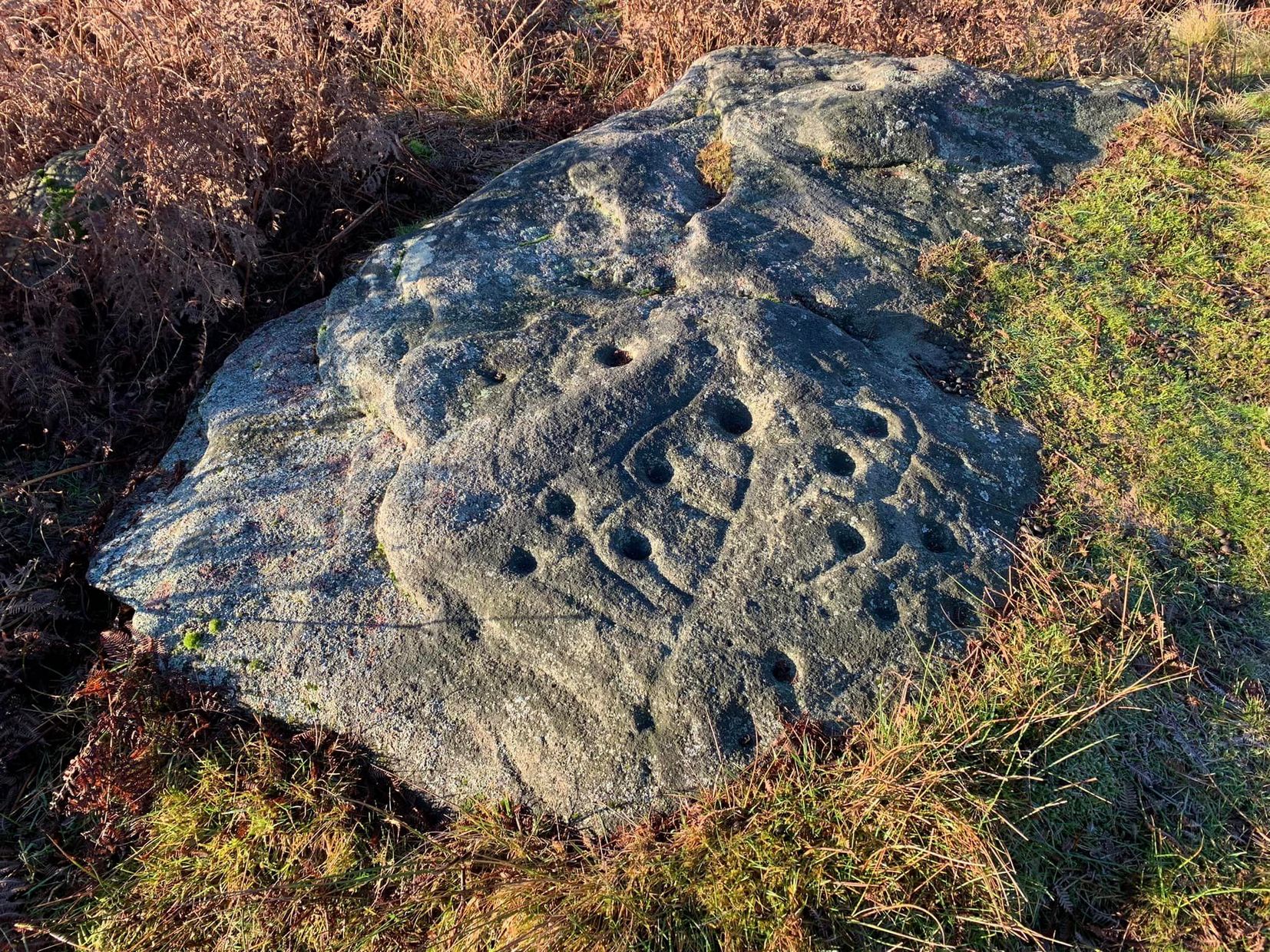
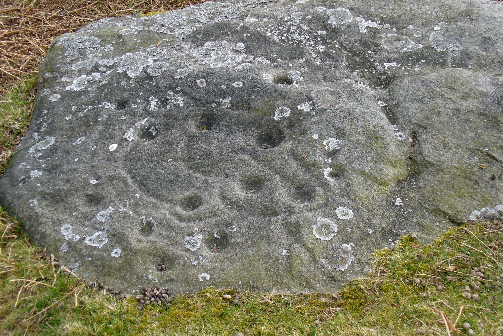
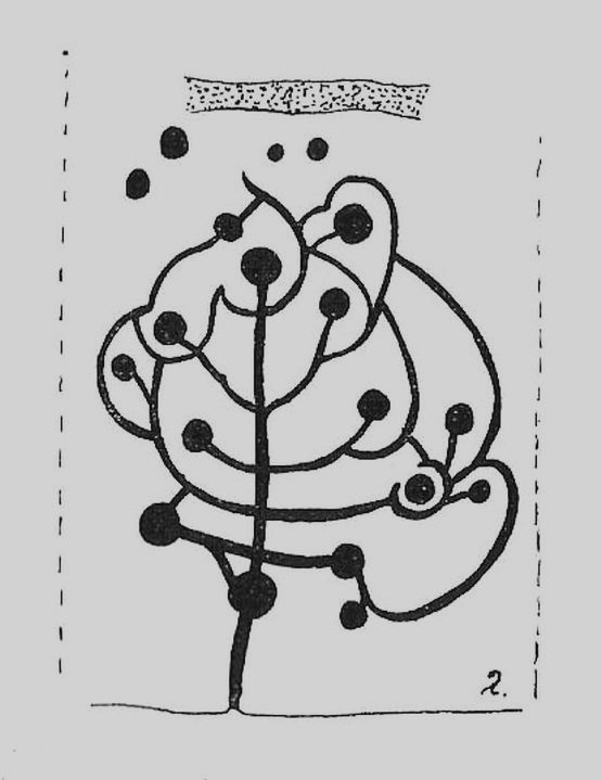
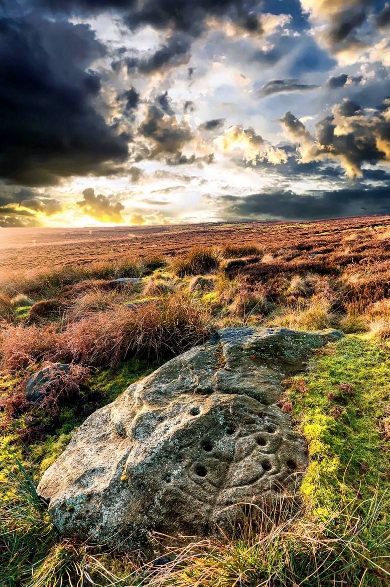
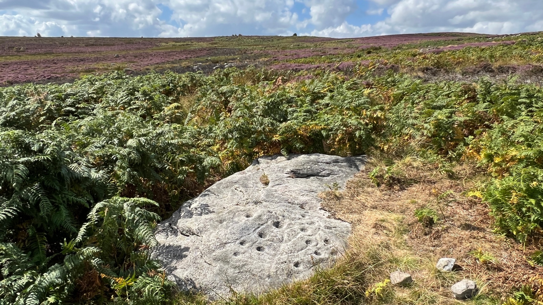
The most well-known and one of the more decorative of all the carvings in and around the Snowden Moor region is the Tree of Life Stone. In the 1930s, Eric Cowling first reported how, “this fine marking is the only one which appears to be known to the people of the district,” due in part to it being a site of local social activities (though nothing is said of this place in William Grainge’s [1895] survey). Cowling (1937) described the carving thus:
close-up of main featuresEric Cowling’s sketch
“This stone lies alongside the bridle path which skirts the southwest corner of the enclosed moorland above the hamlet of Low Snowden. A large flat rock surface at ground level has a number of cups joined together by a series of curved grooves, which in their turn are connected to a central straight groove. Immediately above the design, a broad groove has been cut across a raised central area as though to isolate the markings from several scattered cups which are to be found on the remaining surface.”
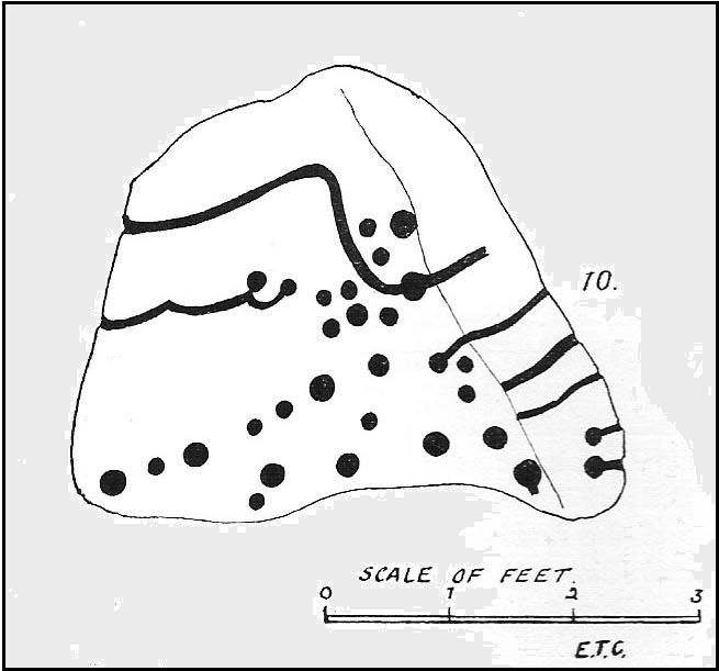
The modern surveyors Boughey & Vickerman (2003) tell us that this highly ornate stone comprises of,
“about 25 cups, with a group at the highest…end and a few isolated, but most in complex design with enclosing grooves suggesting a tree in fruit: hence the name ‘Tree of Life Rock.'”
The Tree of Life StoneBoughey & Vickerman’s sketch
The Coped Stone carving is just a few yards away and, on the slopes below here — as well as on the moor stretching above you — there is an excess of prehistoric remains: enclosures, hut circles, lengths of walling, cairns, other cup-and-ring stones — the vast majority of which has yet to be excavated in any formal sense (are any rich doods out there reading this who might wanna get things going…?). It appears that both the Coped Stone and the Tree of Life carving may have been linked by some ancient walling that appears to run between them.
Another possible variant on the Tree of Life Stone has recently been uncovered on the outskirts of Ilkley; but on this newly-discovered example we find the central ‘trunk’ of the ‘tree’ is a natural crack that runs up the middle of the rock. Up the ‘trunk’ are several short branches with cup-marks on either side, not unlike apples on a tree. Altogether there are at least 12 cups and one ring, with several curious lines, some of which seem geophysical in nature. After several visits to the site, it’s obvious that the ‘tree’ design is more obvious and there are additional faint carved sections on the stone which weren’t visible when it was discovered in heavy rain and poor light.
This is one of very few cup-and-ring stones with folklore attached. Cowling (1937; 1946) reported it to be site of early morning Beltane (May 1) gatherings. The title of the stone, the Tree of Life, was one he heard local people call this site, but “no reason is offered”, he said. About 100 yards below this we find a curious erectile, fertility image on the impressive carving 612, which (he says tenuously!) may (and that’s a dodgy “may”!) relate to the Beltane rites at the Tree of Life.
Tree of Life in situ
In more modern folklore, the old earth mysteries writer Guy Ragland Phillips (1976) suggested the Tree of Life Stone to be an important focal point along one helluva highly speculative ley line: running from the Irish Sea, across land and the Tree of Life stone, continuing way east until hitting the North Sea! If this old ley did have any validity (it doesn’t!), the Tree of Life’s carved partners east and west of here — the Coped Stone and carving no.597 — would have also been on the same line.
References:
Boughey, Keith & Vickerman, E.A., Prehistoric Rock Art of the West Riding, WYAS 2003.
Cowling, Eric T., “Cup and Ring Markings to the North of Otley,” in Yorkshire Archaeological Journal, part 131, 33:3, 1937.
Cowling, Eric T., Rombald’s Way: A Prehistory of Mid-Wharfedale, William Walker: Otley 1946.
Phillips, Guy Ragland, Brigantia — A Mysteriography, RKP: London 1976.
Acknowledgements: Many thanks to James Elkington and to Yorkshire Daz for use of their photos.
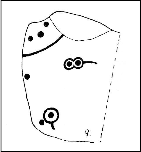
Take the same direction as for cup-and-ring carving 582 from the Askwith Moor Road parking spot, walk up the road (north) 300 yards until you see the disused quarry on the moor to your right. From here, head down onto the moor, straight down past the quarry for about 200 yards, angling slightly to your right. You’ll notice some overgrown scattered mass of rocky ‘lumps’ in the heather — a cairnfield no less! — go just below these and watch out for some rocks emerging from the heather. This carving (and its neighbours) is on one of ‘em!
Archaeology & History
This impressive carving is one of a cluster of petroglyhs that are very close to each other, in the ruins of a cairn-field (though there’s some debate as to whether it’s medieval, prehistoric, or just quarry-spoil). Peppered with many cups on the upper surface of the stone, we also have carved lines and cup-marks along the east-facing edge of the rock aswell. I think it was Eric Cowling (1937) who was the first person to describe this stone (where he listed it as stone no.10 in his Otley survey), telling us that close to the Snowden Carr 582 carving,
“On the rise above No.9, is a cope-shaped boulder which is almost covered with cup markings and winding grooves. One broad groove winds from the ridge, rising from a cup, and is continued to the margin. Two cups are linked by a curve which is continued to the same edge. The eastern side of the stone is almost upright and bears two cups with grooves running to ground level.”
Due to the similarities in design on this stone and that of carving no.618 in Fewston valley bottom a half-mile away, Cowling thought that it likely that the same person did both carvings. Well….y’ never know!
References:
Boughey, Keith & Vickerman, E.A., Prehistoric Rock Art of the West Riding, WYAS 2003.
Cowling, Eric T., “Cup and Ring Markings to the North of Otley,” in Yorkshire Archaeological Journal, volume 33, 1937.
Cowling, Eric T., Rombald’s Way: A Prehistory of Mid-Wharfedale, William Walker: Otley 1946.
Not too difficult to locate if you don’t mind wandering to and fro in deep heather. From the Askwith Moor Road parking spot, walk up the road (north) 300 yards until you see the disused quarry on the moor to your right. From here, head onto the moor, straight down past the quarry for about 200 yards, angling slightly to your right. You’ll notice some overgrown ‘lumps’ in the heather — deemed as a cairnfield by archaeologists — go just below these and watch out for some rocks emerging from the heather. This carving (and its neighbours) is on one of ’em!
Archaeology & History
This curiously-shaped large rock has several worn cup-and-rings on its upper surface, with several cup-marks aswell. Two deeply etched lines running down the edge of the rock have also been pecked away as part of the carving, in contrast to the distinguishing natural water-worn line that runs diagonally along and down to the bottom of the stone.
The site was first described by Eric Cowling (1937), who labelled it as Carving no.9 in his survey, saying:
Carving 582, looking SWCarving from above
“At the eastern and lower end of the barrow group on Snowden Carr is a cluster of angular boulders, one of which has several markings cut on the upper surface. There is a cup and ring on the highest, and alongside two rings are joined together and enclose separate cups. One corner of the area is isolated by a groove running from edge to edge, and within this enclosure are three cups.”
Catalogued as ‘stone 582’ in Boughey & Vickerman’s (2003) survey, their description of the carving was one with “fourteen possible cups, several with indications of a ring, some of which intersect; grooves.”
References:
Boughey, Keith & Vickerman, E.A., Prehistoric Rock Art of the West Riding, WYAS 2003.
Cowling, Eric T., “Cup and Ring Markings to the North of Otley,” in Yorkshire Archaeological Journal, part 131, 33:3, 1937.
Cowling, Eric T., Rombald’s Way: A Prehistory of Mid-Wharfedale, William Walker: Otley 1946.
Walk about a mile along West Lane from Askwith village, towards Ilkley, until you reach a notable rounded bend in the road where, in the field immediately above you (behind the thorns) on your left, is a small scatter of large rocks at the edge of the field. One of these is what you’re after! (although this stone is just a couple of yards from the roadside, you can’t just pull up here and have a look — unless you’re an idiot! — without causing one hellova bad accident. So don’t do it!)
Archaeology & History
Carving no.509, Askwith
First described in Boughey & Vickerman’s (2003) survey, this is a curious “design” — if indeed that’s the right word! On the upper surface we can see, very clearly, one large cup and two deep curved lines set away from the cup-marking. One of these lines appears to curve along and down the edge of the rock and, on the shaded side below (somewhat overgrown with nettles when we were looking at it), what may be another large cup-mark and a continuation of the same “carved” line, roughly as drawn in the 2003 survey. It looks pretty good (if you’re a sad rock-art freak like me), but there could be another reason for the markings…
A mile upstream on the eastern edges of the wooded Scales Gill valley (known in previous centuries as both St. Helen’s Ghyll and the Fairy Dell), recent forestry and industrial work has scarred a number of rocks with engraved lines upon more faded cups or gunshot marks. When we wandered up here a few days ago and found a couple of these recently scarred stones, I remarked on how, in years to come, unless we made note of these very modern curves and grooves on the rocks, that future archaeologists will be cataloguing them as cup-and-ring stones. Several hours later on the way back home from our moorland wanderings, we ventured upon this, stone no.509.
I mention this for good reason: as a century back, only 100 yards away, are the remains of what was an old quarry that used industrial machinery similar to the ones that have made the recent curved markings on the stones a mile up the valley. And as we can see quite clearly with this stone and its companions, they’ve been moved and dumped into their present position at the field-side. We should keep this ingredient in mind when looking at this stone, just in case the archaeologists who’ve logged this as prehistoric have got their dates out by a few thousand years. With any luck however, I’ve got it all wrong…
References:
Boughey, Keith & Vickerman, E.A., Prehistoric Rock Art of the West Riding, WYAS 2003.
From the Askwith Moor car-park, walk down the road (south) for 2-300 yards until you reach the gate on the right-hand side of the road. Go thru this and turn immediately left, following the fence along, parallel to the road for about 100 yards (if you reach the small disused quarry, you’ve gone 100 yards too far), then walk into the heath, up near the top of the little peak and walk down the other side of the slope for about 80 yards. You’re getting damn close — look around!
Archaeology & History
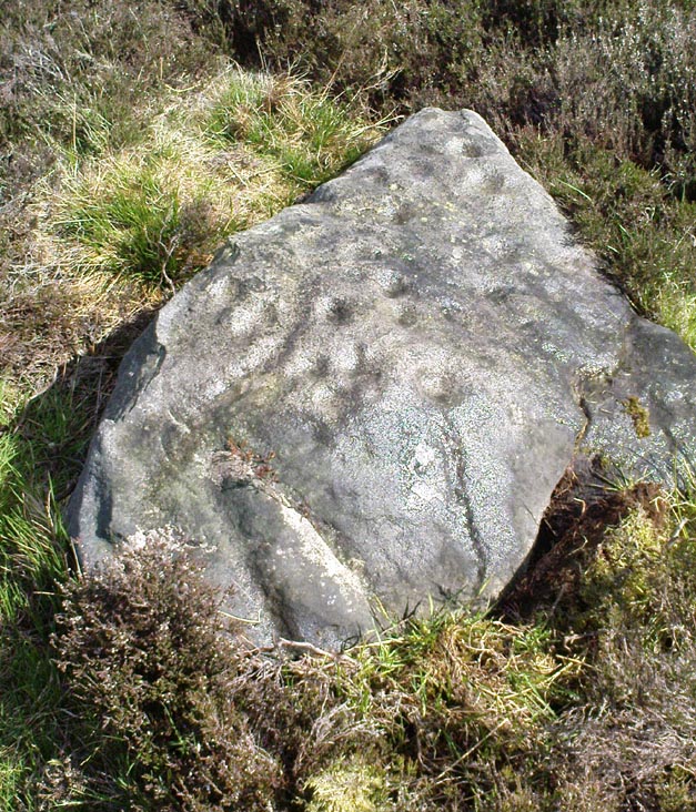
First found on the afternoon of May 13, 2010, in the company of Dave Hazell — though at the time the light was poor and the sky was grey and overcast, not allowing for any decent images being made. We returned here yesterday under a lovely clear sky for most of the day (and without the polluting roars of planes from the nearby airport, thanks to that great Icelandic volcano [keep it going!], making it even better) and got some decent photos this time.
Sketch of basic designClose-up of some cups
It’s only a small low stone, slightly sloping (similar in size and form to carving no.535 about 100 yards west of here), and is gonna be very difficult to find when the heather is in full growth. But thankfully when we found it last week, the heather had been burnt back. Whilst there are two large and very notable cups here — one on the west-facing vertical edge of the stone, the other on its south-facing slope — several others are more troublesome to see clearly, both through a mixture of age and erosion. The other cups are a little smaller aswell, being very similar in status to the curious small cup-markings on the Lattice Stone carving (no.481). One cluster of these smaller cups are arranged in a curved T-shape formation around the middle to eastern-side of the rock. Below this are what seems to be a long singular cup, but upon feeling this — the Beckensall technique — the hardworking Keighley volunteer Michala Potts found it seemed to consist of three small cups all linked to each other. Attached to this section, a small groove runs up to the aforementioned T-formation cluster. Whilst at the top-end of the stone is what seems to be another larger cup-marking, but I’m not sure whether it’s Nature’s handiwork, or artificial. A few more visits here might enable us to say one way or the other!
There are no other archaeological remains immediately adjacent. Another “possible” cup-marked rock (more than twice the size of this stone) can be found about 30 yards further uphill, next to another large stone. But one of the nice things about this small carving is its position in the landscape: an excellent view opens up of mid-Wharfedale below you, and the uphills of Rombald’s Moor is on the far side of the valley. Make of it what you will…
References:
Boughey, Keith & Vickerman, E.A., Prehistoric Rock Art of the West Riding, WYAS 2003.
To get here, follow the same directions to reach the ornate Lunar Stone. Once here, walk about 20 yards west towards where the brow of the hill begins to slope down. Amble about and you’ll easily find it.
Archaeology & History
This is a fascinating carving. Fascinating, inasmuch as it seemingly keeps changing appearance when Nature moves her daylight hues and whimsical unpredictability betwixt the hills, surrounding landscape and human observer. Depending very much where you stand and when you look at this small rock — dappled with unacknowledged veils of sunlights, grey winds and other natural forces — determines what the stone shows you. This carving as much as any upon this hill shows once again the hugely neglected dynamic between human purveyor and Nature’s powerful subtlety: an organic exchange of moods from stone to man and back again; very much how our ancestors saw things to be…
Pecked lines clearly visible on the far end of the rockCarving from above
For if we were to merely pay attention to what the reference books tell us about this carving (good reference books though they are!), we’d simply be seeing a rock possessing a “cup and partial ring and two other possible cups”, as Boughey & Vickerman (2003) and other students might do. But then, if conditions change, only subtly, and we gaze instead of study, other things can emerge. And just such a thing happened when we came here yesterday…
On my first visit here I could only see a single cup-marking, with another ‘debatable’ close by. The light of day wasn’t quite right it seemed. But when we visited here yesterday, the sun, the light, the land and our ambling minds saw much more unveiled from this old grey surface. Whilst two cups-and-rings seem to link with another cup on the lower end of the stone, amidst the natural cracks and fissures, on the higher end are very distinct carved pecked lines, one of which has been blatantly cut onto, or upon, the long curving crack which runs from one end of the stone to the other. As this carved line emerges out of the natural crack, it heads upwards. As it does so, another line has been pecked running off it to the left and then curves back down the sloping rock-face once again. But in this previously unrecognised carved section, these lines may extend even further up the rock…..it’s hard to say for sure. We could do with greater analysis of its surface, with further observations under yet more lighting conditions.
References:
Boughey, Keith & Vickerman, E.A., Prehistoric Rock Art of the West Riding, WYAS 2003.
Hedges, John (ed.), The Carved Rocks on Rombalds Moor, WYMCC: Wakefield 1986.
Difficult to locate when the heather’s deep, but, from the Askwith Moor Road car-parking spot, walk up the road till you hit the fencing that cuts across Snowden Moor on your right. Follow the fence across the moor for about 300 yards where the moorland slope increases downhill. Go down here, keeping to the northern side of the fence and zigzag about. Good luck!
Archaeology & History
Cup-marked stone, Snowden Carr
On the hillside west of the Snowden Moor Settlement is this previously unrecorded cup-marked stone, discovered by Richard Stroud in May 2005. From the photo you get the impression there are perhaps 10 cup-markings etched onto the stone here, but looking at the site in the cold light of day, we both reckoned that perhaps just two or three of them were man-made. This is one of them carvings which has you scratching your head about the problems with some “carvings” and the difficulty one can sometimes have when it comes to answering the simple query about whether they’re natural or man-made.
It’s worth a look this one — not least because, when the conditions are right and the heather’s been burnt back, there’s one helluva decent prehistoric settlement very close by, giving you even more to puzzle over…