The most well-known of prehistoric monuments. They are ostensibly rings of upright standing stones, generally ellipsoid in structure (Alexander Thom did the 7-category assessment), with seemingly multifunctional usage: moot sites, ritual centres and probably alignments. Generally created from the late neolithic through to Iron Age period. In this category are also included sites now defined as ‘ring cairns’ and other circular neolithic and Bronze Age monuments – but it must be stressed that the function of such sites differs from the standard megalithic rings.
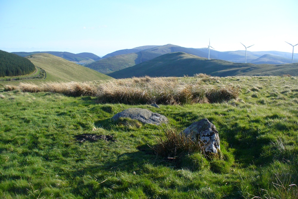
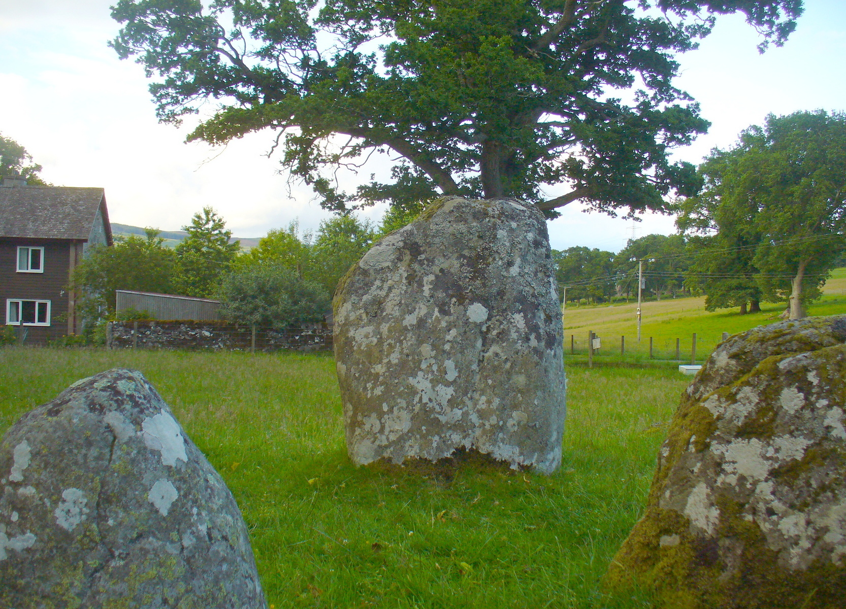
Takes a bitta finding this one. Best found by going along the gorgeous, little-known Dunning Glen in the eastern Ochils, till you reach Littlerig house. Cross the road from there and follow the line of the burn and forest till it veers sharp left. Keep along the fencing until the marshland levels out and streams fall away both east and west. From here, walk uphill until you reach level ground, then, looking down the Borland Glen, zigzag downhill for 100 yards. Keep your eyes peeled for stones emerging from the Juncus grasses.
Archaeology & History
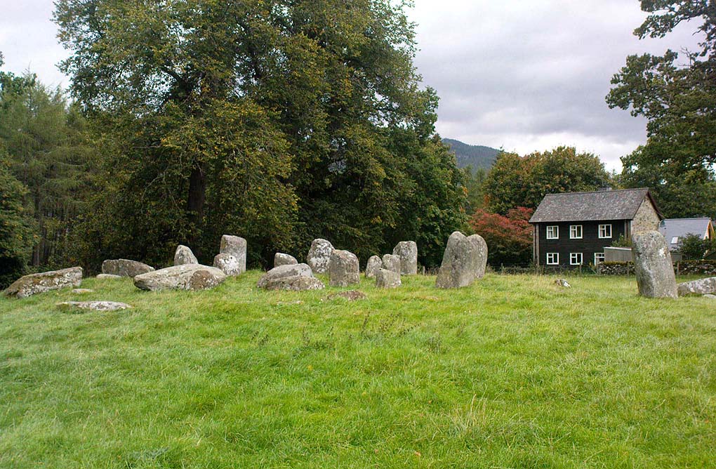
This four-poster stone circle isn’t included in Aubrey Burl’s (1988) survey of that name, nor his 2000 AD magnum opus on megaliths. The site appears to have only recently been rediscovered. Shown on modern OS-maps in non-antiquated lettering, this may be due to verification being required to authenticate its prehistoric status. It’s certainly in a peculiar position in the landscape here — and seems more likely to have been built just 100 yards uphill on the level grassland plain where views east, south and west open up almost with the majesty of Castlerigg!
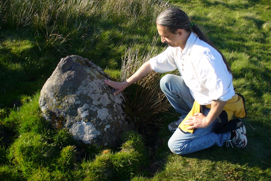
Fondling & puzzling over cup-marks on one of the stones
When Paul Hornby and I ventured here yesterday, we mistook the arc of three stones on the flat plain with the ring of stones that are down the Borland Glen slope ahead of us, so good was the position! But at least one thing came of this: of the arc of three stones shown in the photos here, one of the rocks possesses cup-markings, which you can make out here in one of the close-ups.
The dimensions of the four stones that make up the ‘circle’ down the slope was measured and described by the Scottish Royal Commission lads as follows:
It comprises four stones, which define a trapezium measuring 3.2m along its N and W sides, 2.7m along the S and 2.5m along the E. All the stones are set square at the corners with their long axes lying E and W, and they present a long flat face to the interior. The two on the N are markedly larger than the others, and that on the NW is also the tallest. The dimensions of the stones are as follows: NW – 1m by 0.5m and 0.65m high, NE – 0.8m by 0.4m and 0.3m high, SE – 0.73m by 0.43m and 0.2m high and SW – 0.73m by 0.38m and 0.4m high.
One of the most notable features a visitor to this site will find, is the utter silence as you walk up the slopes to reach the place. And then, once away in the opening landscape, a view of velvet Earth in all Her beautiful shades surrounds you – assuming you go here on a sunny day! Well worth the wander if quiet hidden megaliths are your pleasure…
References:
Burl, Aubrey, Four Posters: Bronze Age Stone Circles of Western Europe, BAR 195: Oxford 1988.
Burl, Aubrey, The Stone Circles of Britain, Ireland and Brittany, Yale University Press 2000.
Acknowledgements: Many thanks to Paul Hornby for use of his photos.
Stone Circles (destroyed): OS Grid Reference – SE 170 810
Archaeology & History
I was hoping to get a Northern Antiquarian team to explore this arena before moving to Scotland, as I lived in hope that we might uncover some remains of an important cluster of megalithic rings in this quiet North Yorkshire area — but we didn’t manage to get here. So this short profile is one based purely on texts.
A mile east of the standing stone and impressive cup-and-ring carvings of West Agra, was once to be found several stone circles — according to John Fisher (1865), who told us about them in his magnum opus on the history of the region. Not to be confused with the giant Druid’s Temple a couple of miles south, Fisher was contextualizing them with the “huge circles of upright stones” which our great heathen ancestors built. Although he made some mistakes trying to link the local place-names with these stone circles (a common pastime of Victorian writers), his remarks still make interesting reading. He told that,
“In this parish there are places which fully answer to this description, as well in situation and appearance, as in the names which they still bear. I refer more especially to Healey-Baals, Beldin Gill, and Baal Hill, which latter place is situate either upon or near to the range of hills known by the name of Healey-Baals. The very name of Baal-Hill, without reference to its appearance or locality, indicates that the place is a hill dedicated to the worship of the heathen god Baal; and the name Healey-Baals, according to the interpretation which I put upon these words, is, if possible, still more conclusive of the matter. I take it that the name of Healey is derived from Heil, holy or sacred, and ley, land consisting of fallow-ground, pastures, or meadows. If, therefore, I am right in my interpretation of the name of Healey, then Healey-Baals means simply land sacred to Baal. This supposition is strengthened by the circumstance of circles of upright stones having recently existed near to the place, and from ancient relics which have been found within the parish, and at but a short distance from Healey and Healey-Baals, which are supposed to have been used in the mystical rites of the Druids or priests of Britain, for at least antiquaries can assign no other use to them…”
There are very few other references I can find that tell of these lost stone circles. Edmund Bogg (1906) mentioned them briefly, saying that between Fearby and the hamlet of Healey a mile west, “there were formerly circles of upright stones and other relics suggestive of druidical origin.” But there’s little more.
In exploring the local field-names we find that three of them here carried the name “Standing Stones” – which seems to tell us where once we could find these old stones. It may be possible that some of the stones were removed into the hedgerows at the sides of the fields.
Folklore
Fisher told of the local tradition of quarterly fire ceremonies close by, which he thought may have related to religious practices at the stone circles, telling:
“There are traditions, too, which have been handed down to us, to the effect that the heathen custom of making feasts and Baal-fires (which although unknown to the persons making them, were in truth so made in honour of Baal) have been continued until very recent times in this district — and especially in Nidderdale — the remembrance of which is transmitted to us in the annual feast which is still held at Healey.”
References:
Bogg, Edmund, Richmondshire and the Vale of Mowbray, James Miles: Leeds 1906.
Cunliffe-Lister, Susan, Days of Yore, privately printed: Bath 1978.
Fisher, John, The History and Antiquities of Masham and Mashamshire, Simpkin Marshall: London 1865.
Smith, A.H., The Place-Names of the North Riding of Yorkshire, Cambridge University Press 1928.
‘Stone Circle’ (destroyed): OS Grid Reference – NS 86 95
Archaeology & History
In Alex Wilson’s (1901) rare work he gives the only reference of what may have been a stone circle once found in the township of Tullibody. On a talk given at the Alloa Archaeology Society in the 19th century, the site was mentioned by one of the speakers in his talk on the standing stones of Stirlingshire and district. Mr Wilson told us:
“…at a meeting in November 1871, Rev. Mr Bryson made one of his first speeches before the Society, and spoke of Boulders found in the district, and how these were gradually disappearing owing to the utilitarian spirit of the age. Mr Bryson related how that he had been informed that about 60 or 70 years ago there existed seven or eight boulders round about the Boulder at Tullibody, which Mr Duncan had spoken of.”
This is a brief but intriguing account! Whether we can ascribe the “seven or eight boulders” in the description as merely glacial erratics, or whether the ruins of a stone circle were here as the description seems to imply, we don’t know. If anyone has any additional information they can add to this account, please let us know.
References:
Wilson, Alex, Review of Proceedings since Inauguaration, Alloa Society of Natural Science and Archaeology, Buchan Bros: Alloa 1901.
Balbirnie stone circle – with Marion checking it out!
Take the A92 road running north out of Glenrothes towards Freuchie and, after a couple of miles out of town, you’ll hit the B969 road on your left. Across from here on the other side of the road, you’ve just passed a small B-road that takes you to Markinch. That’s where you need to be! Go along there for less than 100 yards and turn first right, swerving along the tree-lined road for 200 yards or so. Watch out, just before the first house on your left, for a footpath which leads into the woods. Walk down it, barely 10 yards!
Archaeology & History
This is a lovely megalithic ring in a lovely setting – albeit a new one. The circle was originally positioned some 125 yards northwest of here and would have been destroyed, but was thankfully reconstructed by Fife Council before road-widening of the A92 was done. And the job’s a good one! But as Burl (2005) tells, this wasn’t the first time Balbirnie had been threatened with damage:
The southeast stones & cistsBalbirnie from the roadside, looking SE
“With some stones removed in the eighteenth century, dug into in 1883 when bones and sherds were found, damaged by trees, it was finally excavated and restored in 1970-71,” before the main road was built. Thankfully it’s still here – and an excellent stone circle it is! However, the reconstructed site here doesn’t show the circle in its entirety. Originally there were ten standing stones making up the ring, as opposed to the seven you can see today.
The site was built amidst the scatter of other larger, and once more impressive, mythically important monuments than the circle – but it’s as likely that the circle added more to the sacred dimensions of the region as a whole when it first came to be built. For on the other side of the A92 we can still see the denuded remains of the Balfarg Riding School Henge, with imitations of its internal upright posts resurrected into position to give an idea of what once stood inside the sacred enclosure. And then about 200 yards west of that, the gigantic Balfarg Henge is impressively surrounded by a modern housing estate, built with the henge in mind, with its outlying megaliths and internal level surface area graciously intact. It’s a truly impressive prehistoric area all round, although the Balbirnie stone circle was built some considerable time after the two henges had been done, many centuries later…
Before the circle was moved, the consensus profile of the site was that given by the Royal Commission (1933) lads following their visit here in June 1925, when they told it looked like this:
Royal Commission ground-plan, c.1933
“At the southern end of a small wood on the east side of the main road from Kirkcaldy to Falkland, about 180 yards south of Balbirnie Lodge, are the remains of a large circular cairn and of the setting of standing stones by which it was once surrounded… The circle, which has had a diameter of some 48 feet, has been composed of sandstone boulders. Four of these are still in place, but one other on the southeast has been slightly displaced, while against the stone on the northeast lie two large boulders, which apparently have been transferred to this position. Any other stones that may once have existed have been removed or destroyed. The greatest height above ground of any of those that survive is 5 feet 6 inches, while one, which rises no more than 2 feet, measures in circumference as much as 9 feet 9 inches at the base. The cairn itself seems to have been broken into at two points. No record of these excavations appears to be extant, but a number of fragments of cinerary urns from the site are preserved in the National Museum. These indicate that, as might have been inferred from its general character, the monument was sepulchral and dates from the Bronze Age.”
Sepulchral indeed. When the stone circle was excavated at the beginning of the 1970s by J.N.G. Ritchie (1974) and his mates, it was discovered this was a primary function of the site. As Burl (2000) wrote:
“At Balbirnie patches of cremated bone lay underneath some circle-stones. Whatever the ceremonies here they were interrupted when the site was converted into a cemetery. Four or five cists associated with a late beaker and a jet button were constructed within the ring. The date of about 1650 BC came from wood alongside the beaker. Stretches of low walling were put up between the stones forming a continuous barrier…analogous to the embanked stone circles elsewhere in Britain that seem generally to belong to a period in the mid-second millennium… But the first cists did not long remain undisturbed and were seemingly rifled when later cists were built that contained the cremations of women and children… One of these later cists held a food-vessel and a flint knife.
“The stone circle was further abused. A low cairn was piled over all the cists. Sherds of deliberately broken urns, one with barley impressions, were scattered amongst the boulders, intermingled with small coagulations of burnt human bone. This last phase at Balbirnie occurred late in the second millennium BC, for a C-14 determination of…1200 to 900 BC came from the land surface that had built up within the ring during the centuries while the stone circle remained open to the weather.”
Measuring 49 feet across at the widest, this flattened ellipse also possessed a curious rectangular section of laid stone, near the middle of this circle, almost ‘Roman-road’ like in appearance and covering about a quarter of the internal arena. It’s visible today at the reconstructed site and looks almost intrusive! Measuring some 11 feet by 9 feet, the flat stone surface has been suggested as a place where corpses were rested.
Also found within two of the tombs inside the circle were the cup-and-ring marked stones of Balbirnie 1 and Balbirnie 2, showing yet again the relationship that some of these carvings have with spirits of the dead.
References:
Burl, Aubrey, “Intimations of Numeracy in the Neolithic and Bronze Age Societies of the British Isles (c.3200-1200 BC),” in Archaeological Journal, volume 133, 1976.
Burl, Aubrey, Rings of Stone, BCA: London 1979.
Burl, Aubrey, The Stone Circles of Britain, Ireland and Brittany, Yale University Press 2000.
Burl, Aubrey, A Guide to the Stone Circles of Britain, Ireland and Brittany, Yale University Press 2005.
Denston, C.B., “The Cremated Remains from Balbirnie, Fife,” in Archaeological Journal, volume 131, 1974.
Ritchie, J.N.G., “Excavation of the Stone Circle and Cairn at Balbirnie, Fife,” in Archaeological Journal, volume 131, 1974.
Royal Commission on the Ancient & Historical Monuments, Scotland, Inventory of Monuments and Constructions in the Counties of Fife, Kinross and Clackmannan, HMSO: Edinburgh 1933.
Acknowledgements: Huge thanks to Marion Woolley for getting us out to see this and the related neolithic monuments. Cheers m’ dears!
Stone Circle (destroyed): OS Grid Reference – NS 906 925
Archaeology & History
Clump of trees near the site of the olde circle…
This is another megalithic ring that appears to have been destroyed, sometime around 1923. It was one of a series of very important Bronze Age monuments that could once be seen along the ridge of Hawk Hill on the eastern outskirts of Alloa. A series of important prehistoric tombs scattered the area, and a tall early medieval cross was erected near the site to try christianize this important heathen arena. Sadly, we have few details available of the circle itself. The Royal Commission (1933) report simply said of it:
“This circle occupied a site immediately behind the lodge at the eastern extremity of the same (ridge) as the cairn (on Hawk Hill). It was, we are informed, entirely removed about ten years ago.”
In the cultivated field there is a curious circular clump of trees which I thought might harbour some of the fallen monoliths, but a scattering of overgrown stones within them did not have that prehistoric pedigree about them. Perhaps better luck might be had in the trees at the end of the field… The tall Hawk Hill Cross can be seen just a couple of hundred yards or so immediately to the west.
References:
Royal Commission on Ancient & Historical Monuments, Scotland, Fife, Kinross and Clackmannan, HMSO: Edinburgh 1933.
Virtually nothing is known of a stone circle that was described in the 18th century old Statistical Account of Scotland, where a ring of stones was seen “in the parks of Gleneagles.” Its exact whereabouts remains unknown and the grid-reference given for the circle is an approximation. The writer told that this was “supposed to have been places of Druidical worship,” and it is mentioned alongside the megalithic sites at nearby Sheriffmuir and the Glebe.
The circle is mentioned without further details on the Canmore website. A number of stones above St. Mungo’s Well looked promising when I was bimbling in the area the other week — and as the landscape levels out above the well towards Glen Devon, we have a promising panorama, but there was nothing there. It would be good to have a team of us bimbling round here to see what could be found. However, the site may well have been destroyed. Any further information about this site would be hugely welcome!
References:
Sinclair, John, The Statistical Account of Scotland, 1791-1799 – volume 3, EP: Wakefield 1979.
From Dunblane, head out east up and along Glen Road up towards Sheriffmuir. Turn left at the junction of the Sheriffmuir Inn and keep going for about 3 miles, keeping your eyes peeled for the TV mast on the left-hand side of the road. 100 yards past this, you can park-up. Walk down the road another 100 yards until you get to the next gate in the fence. According to Ordnance Survey, the circle is/was across the road from here.
Archaeology & History
Although local tradition and historical accounts tells of a circle of seven stones nearby, there’s little to be seen at the position shown on the OS-map. On one side of the road, just above the embankment, there are hardly any rocks at all to even remotely ascribe as being touched by humans – i.e., there’s nowt there! On the other side of the road, close to the parking spot, we do find a small cluster of rocks, perhaps hinting at a cairn structure, and then another longer stone embedded in the embankment 20 yards further down – but even these ‘remains’ (if you could call them that) seem flimsy evidence indeed of any megalithic structure here. There is also a small arc of small stones by the roadside in the same area — but even these would be stretching imagination into psilocybe realms to call them a stone circle! So I’m not sure what’s happened here. My gut feeling told me that the position of this ‘stone circle’ shown on the OS-map was wrong, but that some remains of it would be found nearby. But that could be bullshit.
Nevertheless, there are what seems to be the remains of prehistoric walling and possible enclosures close by, so a greater examination and bimble in the heathlands here is on the cards in the coming weeks. If anyone living close by has further information on this spot, or fancies walking back-and-forth through the boggy moors (it’s arduous and not for the faint-hearted) in search of such sites, lemme know! I have the feeling that there’s more to be found along this stretch of countryside.
Whether this site was the “druidical circle” mentioned in the Old Statistical Account of Scotland “in the heights of Sheriffmuir,”(vol.3, p.210), or the lost Harperstone Circle, we cannot be sure. But an early account of this lost circle was written in John Monteath’s (1885) collection of Dunblane folktales. He told:
“About two miles south-west of the village of Blackford, on the Sheriff-muir road, and near to the farm-house of Easter-Biggs, is an arch of stones, seven in number, called the “Seven Stanes,” varying from perhaps a ton to two tons each. One of these is of a round prismatical shape, and stands in an erect position. Beside these lies a large bullet of stone, called “Wallace’s Puttin’ Stane,” and he is accounted a strong man who can lift it in his arms to the top of the standing one, which is about four feet high, – and a very strong man who is able to toss it over without coming in contact with the upright one. At one time few were to be found of such muscular strength as to accomplish this – not so much from the actual weight of the stone itself, as from the difficulty of retaining hold of it, it being very smooth and circular. This difficulty, however, was obviated about seventy years ago, by the barbarous hand of a mason, to enable himself to perform the feat, since which time a person of ordinary strength can easily lift it…”
It would seem there are or were additional prehistoric sites scattering the eastern edges of the Ochils within a few miles of each other along this ridge, as several accounts from both local newspapers and learned journals talk of a number of places, of differing dimensions. The lost Harperstone Circle is a case in point; and another ‘circle’ mentioned by A.F. Hutchison in 1890, measuring just “10 – 12ft in diameter, of 5 or 6 stones, each about 2ft high” (probably a small cairn circle) differs from Monteath’s description on the Wester Biggs ring.
Folklore
In Monteath’s (1885) account of local Dunblane traditions, the following narrative was given which local people held dear as a truthful statement of these ancient stones:
“Some antiquaries might suppose the ‘Seven Stanes’ to have been, in former times, a Druidical place of worship; but tradition contradicts this, in a manner so distinct and pointed, that none, in anyway acquainted with the connection which, in Scotland in particular, exists between oral testimony and written records, but must be struck with the plausibility of the story which tradition affords…
“The “Seven Stanes” then, instead of being the remains of a Druidical place of worship, tradition informs us, are intended to commemorate a glorious victory obtained by an army of Scottish patriots under Wallace over an English army 10,000 strong, who were taken by surprise and cut to pieces. Wallace, who was not less remarkable for the celerity of his movements than the strength of his arm, determined not only to intercept it, but formed, at the same time, the most daring plan of cutting off their retreat, as if already assured of victory. For this purpose he divided his brave followers into three divisions; one of which he dispatched in the night to the “Seven Stanes” – another was stationed at the Blackhill of Pendreigh, to fall upon the rear – and Wallace himself, with his division, lay on the Muir of Whiteheadston.”
References:
Hutchinson, A.F., “The Standing Stones of Stirling District,” in The Stirling Antiquary, volume 1, 1893.
Monteath, John, Dunblane Traditions, E. Johnstone: Stirling 1885.
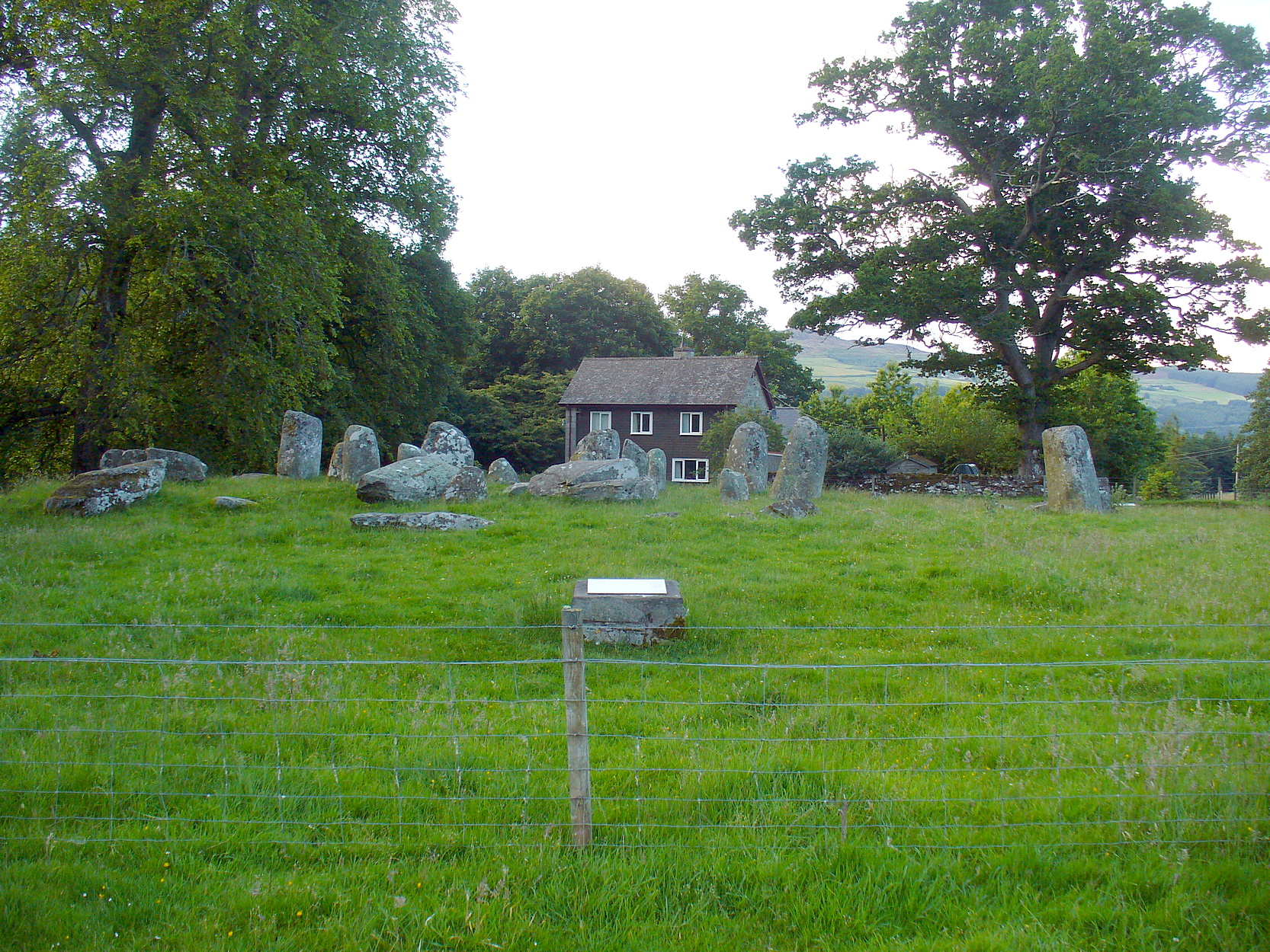
Take the A827 road that runs from Kenmore (top-end of Loch Tay) to Aberfeldy, and about 2 miles outside Kenmore, once you come out of the woodland (past the hidden standing stones of Newhall Bridge) and the fields begin on the east-side of the road, a small dirt-track leads you slightly uphill to the farm and house of Croftmoraig. The stone circle is right in front of the house less than 100 yards up the track (you can see it from the road).
Archaeology & History
A truly fascinating site, whose history is much richer than its mere appearance suggests. It has mythic associations with both moon and sun, a cup-marked stone to the southwest, and an earlier structure that had Aubrey Burl (1979) suggesting was possibly “the dwelling-place of a priest, a witch-doctor, a shaman.” Not bad at all!
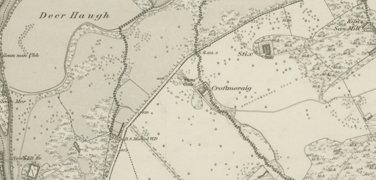
Croft Moraig on 1867 map
The sad thing today is its proximity to the increasingly noisy road to Aberfedly whose begoggled drivers care little for the spirit of place or stones. Here sits a feel of isolation and tranquility broken. But at least the cold information of its architecture is available for tourists and archaeologists alike; at least their depersonalized appreciations are served!
Described first of all (I think) in the old Statistical Account by Colin MacVean (1796), he told Croft Moraig to be one of “several druidical temples” in the area, “perhaps the largest and most entire of any in Scotland,” he thought:
“It is about 60 yards in circumference, and consists of three concentric circles. The stones in the outermost (ring) are not so large as those in the inner circles, and are not, like them, set on end.”
Hutcheson’s 1889 planCroft Moraig, looking N
The first decent archaeocentric evaluation of Croft Moraig was done in the 19th century by Alexander Hutcheson (1889), who gave us not only the first decent ground-plan of the site, but was also the first person to note that there were some faded cup-and-ring markings at the circle. After first directing his antiquarian readers to the site, he described the multiple rings of stones here, that had been built on top of an artificial platform of earth and stones:
“The circles are concentric, three in number, and occupy a little plateau which may be artificial, as the outer circle just covers it, on the gentle slope which here rises towards the south from the public road.
“I have prepared and exhibit a plan of the circles, and for reference have distinguished the stones by numbering them in the plan. The inner circle consists of eight stones all standing, with one exception, No. 3, which presumably has fallen inwards. The next or second circle consists of thirteen much larger stones, nine of which stand erect; Nos. 3 and 5 have presumably fallen in, while Nos. 7 and 9 have fallen outwards. The outer circle is formed by a number of smaller stones placed so as to form a sort of rampart. These are recumbent, and lie generally with their larger axes in the direction of the rampart. The circle measures, over the stones, as follows:
“Inner circle, West to East, 25 ft. 6 ins., North to South, 22 ft. 6 ins.
“Second circle, West to East, 40 ft North to South, 41ft 3in
“Outer circle, West to East, 58 ft North to South, 58ft
The stones are all rounded or water-worn boulders of dolerite, granite, schist, &c. The stones marked A and B are large blocks, 6 feet 6 inches high, 4 feet broad, and 2 feet 6 inches thick, standing upright. C seems to be a large (section) which has fallen from B, and lies flat on the ground.
“At the south-west side and in the line of the outer circle lies the cupmarked stone… If, as has been suggested, the two large blocks A and B formed the entrance to the circles, then the entrance faced towards the south-east. The blocks vary in height from 3 feet to 7 feet above ground, while of those which I have supposed to have fallen, their dimensions are, naturally from the ground-hold having to be added, much greater, amounting in one of them to 9 feet 6 inches long. There is a longish low mound of small stones, like an elongated cairn, which might yield something if it were to be searched. It lies just abreast of the cup-marked stone. I have referred to the recumbent stones in the two inner circles as having probably stood at one time erect. This I have presumed for several reasons, the principal being that one end of each of these stones corresponds in position with the circle formed by the standing stones; and while this is the case the recumbent stones do not preserve a uniformity of direction, but lie indifferently outwards and inwards from the lines of circularity, and at differing angles from these lines…”
Fred Coles’ site planOne of the cup-marked stones
Some twenty years later, the legendary northern antiquarian Fred Coles (1910) brought his lucidity to Croft Moraig and with it, even greater attention to detail. In a lengthy description of each and every aspect of the circle that has yet to be equalled he gave the reader the most detailed description we have. I hope you’ll forgive me adding Mr Coles’ prolonged description, but it is most valuable for anyone wanting to explore the site in greater detail. He wrote:
“As will be seen from the plan…the structural portion of Croft Morag consists, first, of a roughly circular, earthen mound (lettered in small type a-t), some 3 feet high, which is marked off by several stones of a more or less slab-like character, set irregularly upon a circumference of, approximately, 185 feet. This outermost setting, or revetment of stones is visible now only at certain fragments of the arcs; i.e., it is well-defined on the SW at a, where a long Stone, 6 feet 5 inches by 2 feet lies flat, and bears numerous cup-marks…; on the S arc there are five small Stones (b, c, d, e, f) all earthfast and flattish; on the SE are three similar Stones (g, h, i); on the E arc, four (j, k, l, m); on the N arc, very slightly to the west, one very large Stone (n) flush with the ground at the edge of the bank and a good deal overgrown with grass, measuring 8 feet 6 inches by 3 feet 3 inches; farther to the NW are five stones more (o, p, q, r, s), the last three having only very small portions visible; and, still farther round, is the last of what I consider to be these ridge-slabs (t) close under the edge of the great fallen sloping stone D. Thus the total number of measurable and separate stones now resting on the outermost ring is twenty.
“The stones of the intermediate ring constitute the imposing feature of the circle. They are thirteen in total number in the present condition of the circle, but they probably numbered eighteen when the circle was complete. Nine of them are the tallest in the whole group; four of these are prostrate on the W arc. By striking a radius from the common centre of the circle through the centres of these great stones which are erect, to the outermost circumference, the following measures are obtained: from centre of E, the NNW stone, to the ridge 14 feet 6 inches; from F, NNE stone to the ridge 13 feet 4 inches; from G to ridge 14 feet 4 inches; from H to ridge 13 feet 4 inches; and from I, the SE stone, only 10 feet 6 inches. The four fallen blocks, lying as shown A, B, C, D, no doubt stood on this intermediate ring, the diameter of which measured from centre to centre is 38 feet. Now, it must be observed that between A and B and A and I there are Stones (shaded in the plan); these two are erect, the one near B measuring 3 feet in length, 2 feet in breadth, and 3 feet 4 inches in height; it is quite vertical, and is undoubtedly in situ. The other small erect Stone midway between A and I has much the same size’ and features. Between B and C there is shown in outline another of these small stones ‘in line’ with the great pillars which remain on the E arc; and it is quite clear that if this remarkable and novel feature of alternating each tall stone with a very small but vertical block was originally carried out all round this intermediate ring, there would have been eighteen stones in all. Without the most arduous and careful excavation in these interspaces however, it would be extremely difficult, if not impossible, to prove that these small blocks did once stand on the eastern semicircle.
“As illustrating the general size of the great stones, when fully exposed to view, the dimensions of the four fallen blocks are here given: A, 7 feet 7 inches by 4 feet 10 inches, and fully 2 feet thick; B, 9 feet 2 inches by 3 feet 9 inches (on the upper face), and 2 feet 9 inches thick; C, 8 feet by 4 feet, and 3 feet fi inches thick; D, 7 feet by 4 feet 6 inches, and 3 feet thick at its vertical outer edge.
“The five upright stones of the intermediate ring measure as follows: I, the SE stone, 5 feet 6 inches in height, and in girth 11 feet; H, the east stone, 5 feet 8 inches in height, pyramidal in contour, and in girth 11 feet 4 inches; G, the NE stone, 5 feet 3 inches in height and 11 feet in girth; the next stone, F, 5 feet 7½ inches in height and 13 feet 6 inches in girth; and stone E, nearest to the north on the W arc, stands 6 feet 3 inches in height and measures round the base 9 feet 3 inches.
“The stones forming the inner ring, which is a broad oval in form, are eight in number, quite erect, with one exception; the fallen one (shown in outline) is due south of one set at the north point and the distance between these two is 23 feet 8 inches. If however, the distance between the N Stone and the E one at the SSE be taken, this diameter is 26 feet, as against one of 21 feet taken between the NW and SE stones. Measured from the centre of the fallen stone a space of 10 feet 3 inches divides that from the centre of the erect stone on the east, and an equal space divides it from the centre of the stone on the west. Between the N stone and that on its southwest an equal space of 11 feet 3 inches exists as between that stone and its SE stone; but between these last two there is a third almost exactly midway. The fallen stone measures 5 feet 10 inches by 3 feet 9 inches; the NW stone is 4 feet 6 inches in height, the SW stone 3 feet 6 inches, the N stone 3 feet 4 inches, the NE one 2 feet 6 inches, and the stone between it and the fallen block 3 feet 4 inches in height.
“In addition to the feature above noticed, of tall stones alternating with much smaller ones, Croft Morag possesses another noticeable arrangement in the presence of two great massive monoliths (U and V on the plan) standing like the remains of a portal, nearly eight feet outside of the boundary ridge on the SE. Neither of these stones is now absolutely vertical, stone U leaning considerably out towards the SE, and V having a very slight lean inwards to the circle. The former is 6 feet 2 inches in vertical height with a basal girth of nearly 12 feet, which is probably an under-estimate, for there are two large fragments (w and x) which appear to have been severed from this stone, the edges of which nearest the fragments are rough and sharp. The latter (V) stands 6 feet 4 inches in height and girths 11 feet 8 inches…
“…Besides its complexity of arrangement and the great number of measurable stones, forty-two in all, this circle is emphasised by the existence of a cup-marked stone set in a portion of its structure…on the SW arc… There are nineteen cups in all, only two of which differ much in diameter and depth from the rest, and there does not appear to be anything in their design to suggest a meaning or lend a clue to their symbolism.”
When the monument was excavated by Stuart Piggott and his mates in 1965, it was found to have been built over many centuries. As Aubrey Burl told:
“The first phase, of the late neolithic, consisted of about 14 heavy posts arranged in a horseshoe shape about 25ft 10in x 22ft 10in (7.9 x 7m) with a natural boulder at its centre. Burnt bone was found near this. Outside was a surrounding ditch and at the E was an entrance composed of 2 short rows of posts.
“In the second phase the timbers were replaced by 8 stones graded in height towards the SSW, also erected in a horseshoe 29ft 10 x 21ft (9.1 x 6.4m). A rubble bank was heaped up around it. On it at the SSW was a prostate stone with over 20 cupmarks carved on it. Other cupmarks were ground into the NE stone.
“Finally a circle of 12 stones, about 40ft (12.2m) is diameter, was erected around the megalithic horseshoe with a pair of stones forming an entrance at the ESE. Graves may have been dug at their bases later.”
Fred Coles mentioned a couple of other local names given to the site, one of which – Mary’s Croft – he thought may point “to a dedication to the Virgin.” Another curious place-name next to the site is called Styx,
“which appears to be the modern abbreviated form of the Gaelic word stuicnean. This, Mr Dugald McEwan affirms, meant ground full of overturned forest-trees; and it is therefore probable that in the remote past all the land surrounding the Stone Circle was a deep forest, and perhaps because of its seclusion, this site was selected as the most fitting for the erection of the principal Circle of the district.”
Alex Thom’s ground-plan
When the engineer and archaeoastronomer Alexander Thom (1967) came to examine Croft Moraig, he found the outlying stones to the southeast could have been solar alignment indicators, albeit poor ones. However, the geometric structure of the ring appeared to further confirm the use of his Megalithic Yard by those who built the circle. Thom’s illustration shows his finding, which he described briefly as follows:
“Two concentric circle and an ellipse. The circle diameters drawn are obviously too large and could be as small as 58.5ft outer circle and 41.0ft inner. Outer circle diameter58.5ft = 21.5 MY. Perimeter 67.5 MY = 27 MR. Inner circle diameter 41.0ft = 15.1 MY. Perimeter 47.3 MY = 18.9 MR. Ellipse drawn has major axis 11 MY, minor axis 8 MY, distance between foci is 7.5 MY. Perimeter is 30.0 MY = 12 MR. This ellipse looks slightly large but the triangle on which it is based and the perimeter are almost perfect.”
Folklore
Old lore told that the standing stones of Newhall Bridge 850 yards away (777m) were once connected with the Croft Moraig circle. William Gillies (1938) told this tradition saying,
“that at one time there was a paved way connecting the circle, of which these stones are the remains, with the great Croftmoraig circle.”
Croft Moraig, looking W
Fred Coles also noted that one of the stones in the circle (stone D in his plan) had “been polished by the sliding of generations of children”. This playful action on stones elsewhere in the UK and around the world sometimes relates to fertility rites (i.e., the spirit of the stone could imbue increased fertility upon the practitioner), but Coles made no mention of such rituals here.
References:
Burl, Aubrey, Rings of Stone, Frances Lincoln: London 1979.
Burl, Aubrey, The Stone Circles of Britain, Ireland and Brittany, Yale University Press 2000.
We know very little about the site that once stood here — even Aubrey Burl (2000) found no history here. It seems that antiquarian records were never made in this outlying district and even folklore records seem to have missed this region! (surely not?) A. Lindsay Mitchell (1992) told that the circle here had been built into the church, but knew no more.
First described in the old Statistical Account of Scotland in 1794, even then it was in the past tense, as they said that “a Druidical temple is said to have stood in the vicinity of Balkethly. Not the smallest vestige can now be seen.” Balkaithly Farm is a few hundred yards east of Dunino. In the New Statistical Account of the region in 1845 it was reported that three stones close to the west wall of the minister’s garden at Dunino were said to be part of the ruined circle. The site had truly gone. By 1925 when the Royal Commission (1933) lads visited the place to look for any remains, they told:
“The stone circle which formerly existed near the church at Dunino has now been entirely destroyed, but what are believed to be portions of some of the original stones are built into the dyke on the north side of the roadway at the south-west of the churchyard, about 100 yards east of its junction with the main thoroughfare to St. Andrews.”
A few hundred yards west of the circle, “a short cist containing a fine food-vessel urn was accidentally discovered during ploughing on the farm of Beley.” This was sent to Edinburgh’s National Museum.
Folklore
Locally, there are several places alleged to have been the actual spot where the circle once stood. Several stones within nearby Dunino church have typical Mason marks carved on them which, local folklore says, identifies them as coming from the circle and then subsequently being built into the church. Also in the churchyard is a small carved upright stone, which local people visit and leave offerings upon.
References:
Batchelor, Richard A., Origin of St. Andrews: Moon, Magicians and Maidens in Fife, Shieling: St. Andrews 1997.
Burl, Aubrey, The Stone Circles of Britain, Ireland and Brittany, Yale University Press 2000.
There appear to be no records of any prehistoric circle of any form in the area less than a mile northwest of Whaley Bridge, where the intriguing place-names of Ringstones Clough and Ringstone farm can still be found, nearly 750 years after first being mentioned in local history records. Described by place-name authority J.M. Dodgson (1970) to be simply a “ring of stones” or “stone ring,” little is said of the place in Aubrey Burl’s standard texts. Thankfully we are helped out by R.A. Barnett, who found a reference to the place in John Barnatt’s (1990) local survey, where he gave us a bit of local lore:
“A local man working at the farm said there was a stone circle under the concrete floor of the buildings and that he had seen a photograph showing men sitting on the stones…….. It is not known how much credence to place on this account, it may well be apocryphal.”
Nobody as yet has located this alleged photo. It would be great if anyone could find it!
The site was first mentioned as early as 1285 AD in records of the Palatinate of Chester, as both ‘Ryngstones’ and ‘Ryngstanes’; then later in the Minister’s Accounts of 1550 as the name we know today. But another document found in the Public Records Office dated 1357 AD describes simply le Rynge, or “the ring” itself perhaps. It is described consistently as the standard place-name in numerous other documents from thereon. Was this a cairn circle? A stone circle? A circular enclosure? And where exactly was it? What monument gave this area of land its name?
Good looking contenders for the position of the circle include both Brownough Hill and Black Hill; and what is the story behind the Dipping Stone, above the original source of Ringstone Clough?
References:
Barnatt, John, The Henges, Stone Circles and Ringcairns of the Peak District, Sheffield Archaeological Monographs 1990.
Dodgson, J.M., The Place-Names of Cheshire – volume 1, Cambridge University Press 1970.


sm")
sm")
")
