Mitton Church Cross, Great Mitton, Lancashire

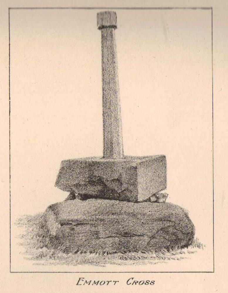
Cross:  OS Grid Reference – SD 7154 3896

Getting Here

Great Mitton Churchyard Cross (after ‘QDanT’)

Take the B6246 road northwest out of Whalley, or else east from Hurst Green, until you hit the little village of Great Mitton, with its churchyard in the middle.  Go into the churchyard and you’ll find this weird-looking cross!

Archaeology & History

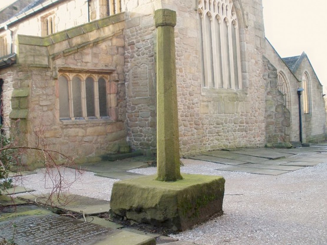
The curious-looking upright in the churchyard here has a mixed history by all accounts.  The oldest portion of the cross is universally ascribed to be the top section, rediscovered when it was dug up “shortly before 1801.” (Ackerley 1947) It possesses a carving of the crucifixion on one side, and some curious figures carved on the other, which some ascribe to being Jesus, but could well be the triple female element which would still have been prevalent in peasant culture at the time it’s thought to have been carved.  The original shaft carrying the ‘cross’ had long since been destroyed and so, according to Jessica Lofthouse (1946),

Carved crosshead (© ‘QDanT’)
Early drawing of cross-head

“In 1897 it was ‘re-erected to commemorate the 1300th anniversary of the reintroduction of christianity into Britain,’ with the new shaft we see today.  This is the oldest relic in Mitton.”

In J. Buckler’s early 1841 drawing of both sides of the carved cross-head we can see in greater detail the nature of the medieval rock art and this was described in Aymer Vallance’s (1920) decorative analysis of carved crosses in England.  He told that

“the cross-head at Mitton, Yorkshire…is peculiar inasmuch as the crucifixion is sculptured on both faces, but in totally different fashions.  That on the west face has the arms stretched horizontally, within a sexfoil frame, and might well be of the thirteenth century.  Whereas the sculpture on the east face, though much more weatherworn, is of a style that could not have been designed before the fourteenth, or perhaps even the fifteenth century.  The arms of the Christ in this instance are drawn upwards in an unusually oblique direction.  It is impossible that these two representations could have been executed at one and the same date.  The circular outline of the head, too, is peculiar, and suggestive rather of a gable-cross than of a standing cross.  Possibly the west face only was sculptured in the first instance, for a gable-cross, the sculpture on the east face being added later in order to adapt the stone for the head of a churchyard cross.”

Although I’ve gotta say that the three carved figures with the upright arms strikes me more as three females than any crucified character and may be an early depiction of the three Mary’s.

One of the early ministers at Mitton church was none other than John Webster, who wrote the highly influential work, Displaying of Supposed Witchcraft, which denounced much of the Church’s obsession and murder of countless people under the auspice of some spurious devil and demonological bollocks which, even today, some still suffer to endure.   Webster was only at Mitton for a few years, before moving into deeper Yorkshire and setting up at Kildwick.

References:

  1. Ackerley, Frederick George, A History of the Parish of Mitton, Aberdeen University Press 1947.
  2. Lofthouse, Jessica, Three Rivers, Robert Hale: London 1946.
  3. Vallance, Aymer, Old Crosses and Lychgates, Batsford: London 1920.

Links:

  1. Pictorial Journey of East Lancashire Crosses

© Paul Bennett, The Northern Antiquarian


Withgill Cross, Great Mitton, Lancashire

Cross:  OS Grid Reference – SD 7060 4062

Getting Here

Withgill cross location (after QDanT)

From Great Mitton village, go up (north) the slightly winding B6243 road for a mile, then take the left turn up the minor country lane, for about 300 yards, till you reach a tiny crossroad of tracks, one leading down to Scott House and the other up to Withgill Farm.  Stop here!  You’re damn close.  From what our man ‘QDanT’ says, this is now to be found behind the hedge by the roadside, on the side of the road where the track runs up to Withgill Farm, tucked low and overgrown close to the ground.  Good luck!

Archaeology & History

Described by Mr Ackerley (1947) as being found

“in the coppice beside the gate to Withgill is the base of another road-side cross,”

Cross-base (after QDanT)

all but overgrown by ivy and lost to the causal eye.  Thankfully our man Danny got on his bike and found the remains of the little fella, all-but invisible beneath the vegetative growth!  Beneath the vegetation, John Dixon told there to be “some interesting 17th century graffiti,” but there’s not much that remains of the old cross.

Folklore

There is a curious story about a legendary church that was once supposed to have been up the track on the hill just above here at the farm.  The story goes,

“that when Mitton church was built, it ought to have been built on Withgill Knowle: that there was a church somewhere about there, and that the stones from it were carted down to Mitton in one night and used in building the present church.”

This bitta folklore is a motif found commonly at prehistoric sites, where stones from our ancient places were uprooted and moved (destroyed) to give way to the new christian mythos.  To my knowledge, no such prehistoric sites are known hereby.  Mr Dixon – over to you dear sir!

References:

  1. Ackerley, Frederick George, A History of the Parish of Mitton in the West Riding of Yorkshire, Aberdeen University Press 1947.

Links:

  1. Pictorial Journey of East Lancashire Crosses
  2. Teddy’s Exploration of the Withgill Cross Base

© Paul Bennett, The Northern Antiquarian


Maen Achwyfan, Whitford, Flintshire

Cross: OS Grid Refence – SJ 129 788

Also Known as:

  1. The Stone of Lamentation
  2. St Cwyfan’s Stone

Getting Here

Maen Achwyfan Cross (after J.O. Westwood)

Go north on the A5026 from the town of Holywell for about 3 miles; at the hamlet of Lloc take the turning first right towards Trelogan village for another mile – the ancient cross stands in the corner of a field at the junction of 3 roads at the turning from Whitford to Trelogan, halfway between Whitford and Sarn. The cross can also be reached via Pantasaph from the A55.

History

The cross probably dates from 1000 AD and is said to be the tallest wheel-headed cross in Wales, standing at 11 feet 3′ in height. The metal fence surrounding the cross spoils the monument quite a bit, but it is there for security reasons.  It is richly decorated on all sides and on the cross-head. Much of the decoration is Celtic in origin, but there are also Viking influences here, probably Northumbrian. On the south face there is a human figure standing on a serpent that has associations with the Norse god Odin; also a three-legged horse that may also be connected to Odin. The north-west face has Celtic pattern-work in the form of the letter “X” and below that another figure (naked) holding a spear. The north-east face is rather eroded, but there is some Celtic-style decoration. There is more knotwork and chainwork elsewhere on the cross with other animal figures.  The wheel-head has a distinctive central boss and a four star-shaped cross radiating from the boss.

Folklore and Legend

The cross is also called ‘The Stone of Lamentation’ because penances were carried out at the cross in the Middle Ages. This act would have concluded with weeping and the ‘act of contrition’ by pilgrims visiting the site whilst making their way between St Winifred’s Well and St David’s.  Legend says that St Cwyfan, a local 7th century Celtic saint preached on this site and set-up the cross – hence the name, Maen Achwyfan.  One local legend tells us that Queen Boudica fought her last battle against the Romans close by in the fields called ‘Cydio ar Leni’ or ‘The fields of the seizing legions’.  During the Middle Ages the monks of Basingwerk Abbey preached at the cross and also set up a chapel for pilgrims just to the south at Whitford.

References:

  1. Allen, J. Romilly, “Celtic Crosses of Wales”, in Archaeologia Cambrensis, 1899.
  2. Owen, Rev. Elias, Old Stone Crosses of the Vale of Clwyd and Neighbouring Parishes, Bernard Quaritch: London & Oswestry 1886.
  3. Sharkey, John, Celtic High Crosses of Wales, Carreg Gwalch: Llanrwst 1998.
  4. Westwood, J.O., Lapidarium Walliæ – The Early Incised and Sculptured Stones of Wales, Oxford University Press 1879.

Copyright © Ray Spencer 2011


Foldys Cross, Towneley, Burnley, Lancashire

Cross:  OS Grid Reference – SD 8523 3066

Also Known as:

  1. Foldy’s Cross

Getting Here

To get to Towneley Park head to the south side of the town close to a junction of two roads heading towards Todmorden and Bacup, from here the park and hall are signposted. The old cross stands 300 metres south-west of Townley Hall in the centre of some pathways leading in the direction of Todmorden road (the A671).

Archaeology & History

Foldys Cross, Burnley (Taylor, 1906)

Foldy’s Cross is a tall slender monument on a carved circular pedestal which sits upon a set of seven square-shaped steps. It dates from 1520 when it stood at the south side of St Peter’s parish church, Burnley. It was set up to commemorate a chaplain of St Peter’s church by the name of John Foldy or Foldys, and was then the town’s market cross or St Peter’s churchyard cross. In 1780 it was badly damaged by a Puritan mob, but the Towneley family rescued it and had it brought to their estate where it was repaired in a haphazard way and placed at the north-eastern side of the hall on the Avenue. In 1911 Burnley Borough Council had the cross completely restored for its Jubilee Year celebrations with various sandstone pieces added to replace sections of the cross including the plinth and set of seven steps – which are thought to be an exact copy of the original ones. The cross was then placed in its current position 300 metres to the south-east of Towneley Hall at an intersection of footpaths leading towards Todmorden road.

The original design of Foldy’s Cross was of the Gothic style which can be seen in the cross-head. It is made of sandstone and has an octagonal shaft with a moulded plinth with sunken panels. These panels contain lettering in the Gothic script. The cross-head is very nice with its decorated four arms, one of which is sunk into the shaft to support the head itself; this appears to be the original moulded head or cap with nicely carved emblems and fleurons on the collar – all typically Gothic in style. In the middle of the cross-head is a rather crude crucifix scene and on the other side the letters “IHS”. On the plinth the inscription reads in Latin:

‘Orate pro anima Johannes Foldys, capellani qui istam crucem fieri fecit Anno Domini MCCCCCXX’

— which when translated reads as, “Pray for the soul of John Foldys, chaplain who caused this cross to be made in the year of Our Lord 1520”.

The cross is now grade II listed and the English Heritage Building identity number is 467232.

References:

  1. Peace, Richard, The Curiosities of England – Lancashire Curiosities, The Dovecot Press Ltd 1997.
  2. Taylor, Henry, The Ancient Crosses and Holy Wells of Lancashire, Sherratt & Hughes: Manchester 1906.

© Ray Spencer, 2011


Grimeford Cross, Adlington, Lancashire

Cross:  OS Grid Reference – SD 6200 1284

Also Known as:

  1. Headless Cross

Archaeology & History

Within the Harris Museum, Preston can be found the Upper section of a pre-Conquest stone ‘cross’. Though much damaged on three of its sides the main face displays the upper section of a horned-helmeted figure holding a sword before it. The spreading horns suggest an important figure from the Viking period in Lancashire (c.900). This large and important piece of sculpture was found during the construction of Rivington reservoir on the River Yarrow near the village of Grimeford, Anderton in the 19th century.

Also found at that time during the reservoir construction was the lower section of a ‘cross’ shaft. This shaft is decorated on all four sides with carvings which include: the figure of a man from the waist down; a trellis filled with geometrical ornamentation of horizontal and vertical straight lines repeated to form a band known as a fret; a modified version of T-fret; and a combination of vine scroll and frets. The top of the shaft serves as the base for what is possibly a post medieval sundial base which has been adapted for use as a direction stone with directions to “Preston, Wiggan, Boulton, and Blagburn” (spelled as on the stone) being carved on the sides.  I would suggest that the two fragments are parts of the same monolith and may even depict the Viking Gunnolf (the latter being my own fancy).  This headless ‘cross’ is sited at the junction on the old road near the Millstone pub in Anderton and Grimeford Lane on the way to Rivington (SD 618 130). The stone is known as the ‘Grimeford Headless Cross’ or more locally as the ‘Headless Boggart’.

Folklore

Legend has it that there used to be a chapel near the junction and a tunnel running to a nearby farm on a hill. In the 16th century shortly before troops came to destroy the chapel, a priest hid in the tunnel and became trapped underground. His body was never found. Many people are said to have seen a ghost at the Headless Cross.

Addenda

To complement John’s entry, here are Mr Taylor’s notes written more than a hundred years ago in his Ancient Crosses and Holy Wells (1906), where he told:

“The HEADLESS CROSS — These words appear on the ordnance maps at a hilly spot in the extreme south-eastern corner of the hundred, five hundred feet above sea level, and distant one mile from the village of Adlington and about the same distance north from Blackrod.  Both villages have histories going back into the far past… A ‘Windy Harbour’, near the cross, sufficiently indicates the breezy nature of the situation.  The well and the ancient stocks are shown in close proximity to the cross.  The remains of the stocks are still in existence.

“Respecting the Headless Cross and others in this locality, Mr J.W. Crompton of Rivington Hall, writes (February, 1899):

“‘In reply to your note, I never heard of any cross, ancient or modern, in Rivington proper.  There was a tenement known as Butter Cross. Possibly some ancient cross may have existed there, but I know of no record to it.  There used to be a Headless Cross in Anderton, but old Mr Ridgeway, of Ridgemont, removed it many years ago, when he had sporting rights rented in that township, and I believe and old road surveyor broke up a cross in Anglezark to repair his roads early in this century: his name was Gerrard.  Crosses seem to have been specially erected to warn people of dangerous moors they were about to cross, and as a call to prayer in this part of the country, they were frequent.’

“…The subjoined deed is printed in the Chartulary of Cockersand Abbey, circa 1184-1190:

‘Grant in frankalmoign from Ranulf Gogard and his heirs to God [and the canons of Cockersand] for the health of the souls of his mother and his wife Edith, of all the land from Fulford to the path which crosses Rascahay Brook, between Heath Charnock and Adlington, as it was marked out by the crosses and marks of the said canons; with comon right of Charnock, in wood and plain, feeding grounds and mast in all other liberties.'”

References:

  1. Taylor, Henry, The Ancient Crosses and Holy Wells of Lancashire, Sherratt & Hughes: Manchester 1906.

© John Dixon, 2010


Whalley Crosses, Whalley, Lancashire

Crosses:  OS Grid Reference – SD 7326 3616

Also Known as:

  1. Paulinus Crosses

Getting Here

Site of church & crosses

Dead easy to find.  Get to the centre of Whalley and walk into the churchyard.  Don’t confuse it with the ruins of the old abbey, or you won’t find the place!

Archaeology & History

I here wish to draw your attention to the three standing crosses in the churchyard (the crosses do not stand in their original positions having being ‘thrown down’ during the Commonwealth and used amongst other things as farm gate-posts):

1) THE EASTERMOST CROSS (Taylor ‘C’):  Standing opposite the chancel door (Priest’s Door, early 13th century retaining the original ironwork and bronze head knocker) is a much-worn cross shaft that only under certain lighting conditions that can any decoration is made out. It has scrollwork as pat of its ornament and a pelleted border. Two figures, heads surrounded by halos, can be made out just above the shaft centre. The head of the cross is not original but of the late 14th century. The cross originally stood over 11ft in height (see drawing reconstruction). Fragments of this cross are built into the fabric of the church, the top section of the shaft and parts of the cross head are held in Blackburn Museum. One fragment can be made out in the outside Chancel wall displaying the pelleted border and some scrollwork. Another fragment is built into the back wall of the Sedilia and is in good condition. A further fragment is built into the back wall of the Bishops Throne, last stall, south side, east adjacent the Sanctuary.

The shaft is set in a broken oblong base that one may have held two or more shafts in the form of a ‘Calvary’.

Cross no.2 in 1904 (after Taylor, 1906)

2) THE WESTERMOST CROSS (Taylor ‘A’):  Originally panelled crosses of this type were brightly painted in red, yellow, green, blue and white. All four sides are decorated but only the east face survives clearly enough to be made out. The shaft was divided into seven panels with roll-mouldings running along each of the panels, of which only six now exist (part of the upper panel, displaying the hallowed head of a figure and cross arm are held by Blackburn Museum). The two lowest panels and the top panel contain geometric and interlace patterns. Halfway is a sculptured panel containing a hallowed human figure, arms akimbo (raised as if giving a blessing). Either side of the figure are two serpents with open mouths. This design is repeated on the side face of the shaft along with two interlace panels. Above the figure panel is one depicting the figure of a bird (an eagle or pelican in her piety?). The lower panel shows that of a beast (a dog or a lion?).

Crosses 1  and 2 clearly show Hiberno-Norse influences, so named after the second and third generation Irish Norwegians who settled Lancashire in the 10th century whose artistic culture became dominant.

Cross no.3 in 1904 (after Taylor, 1906)

3) THE CROSS OPPOSITE THE PORCH (Taylor ‘B’):  This magnificent cross is in a fair state of preservation, although a portion of the upper shaft and three arms of the head are missing. Originally it would have stood at around 10ft in height and is the oldest of the crosses being no later than the late 10th century. The central cross shaft measures approximately 2.2m high and is socketed into a square base stone carved with dog-tooth decoration. It is rectangular in cross section and tapers towards the top where it has been broken. A piece of the shaft about 0.75m in length is missing. All four sides of the shaft depict well-preserved late 10th century decoration comprising foliated scrollwork. The principal ornamentation is on the east and west faces and consists of a central rounded shaft or pole rising from the apex of a gable. At the top of the shaft are the mutilated remains of the carved central boss of the cross head.

Whalley’s Cross 3

The central rounded column forms the axis mundi (cosmic axis, world pillar), being a ubiquitous symbol that crosses human cultures. The image expresses a point of connection between the heavens and earth where the four compass directions meet. At this point travel and correspondence is made between higher and lower realms. Communication from lower realms may ascend to higher ones and blessings from higher realms may descend to lower ones and be disseminated to all. The spot functions as the omphalos (navel), the world’s point of beginning.

The axis mundi image appears in every region of the world and takes many forms: a hill or mountain (Pendle), a tree (Tree of Life, World Ash Tree, etc), a vine, a ladder (Jacob’s Ladder), a stone monolith, a maypole, Sufi whirling, etc. The foliated swirls represent interactive movement along the axis – transmission, unity within multiplicity.

The axis mundi concept has its origins in Indo-European shamanism, and a universally told story is that of the healer traversing the axis mundi to bring back knowledge (benefits/blessings, etc) from the ‘other world’. The Sufi concept of baraka and the Hindu mystical concept of akasha are akin to this.

All three crosses had cross heads of four arms of equal length, each widening at the outer end in an axe shape so that their rims nearly form a circle.

Editor’s Note:  Henry Taylor (1904) described the “remains of other pre-Norman crosses” at the point marked ‘D’ on his map of the church, adding:

“The Bishop of Bristol thus describes the fragments of other crosses at Whalley: ‘A pretty and delicate fragment forms part of the back of the sedilia; there is at least one piece in the south wall of the chancel, outside, and there are fragments lying on the ground.  One of these, showing a system of oval buckles, as it were, with straps through them, closely resembles a stone found — but now lost — at Prestbury…”

Folklore

Taylor mentions how the Whalley crosses were long known as the Paulinus Crosses, “who is said to have been made Archbishop of York in the year 627, and who, it is alleged, preached and baptised in the wild districts far removed from that capital, even in such remote places as Whalley… His name is also attached to an ancient cross…on Longridge Fell.”

References:

  1. Taylor, Henry, The Ancient Crosses and Holy Wells of Lancashire, Sherratt & Hughes: Manchester 1906.
  2. Whitaker, Thomas Dunham, An History of the Original Parish of Whalley and Honor of Clitheroe, Nichols, Son & Bentley: London 1818.

© John Dixon, 2010


Lilla Cross, Fylingdales Moor, North Yorkshire

Cross:  OS Grid Reference – SE 88923 98686

Also Known as:

  1. Lilla’s Cross

Getting Here

Lilla Cross is situated on Fylingdales Moor, north Yorkshire, between Pickering and Whitby at the junction of two major moorland footpaths. It is located close to the Fylingdales Ballistic Missile Early Warning Station – which resemble giant golf balls on the horizon.

Archaeology & History

Woodwark’s 1930s photo of Lilla Cross

The ancient cross is 10 foot high and free-standing but it sits upon what is probably a ruined Bronze-Age bowl barrow called Lilla Howe; the recumbent stones that lie around the base of the cross may form part of that. It is a sturdy, stocky cross that has some letters carved onto it, one in particular being a large letter “C” possibly meaning Christos (Christ) and with that a small thin cross; there are a few other faint letters but these are difficult to decipher now. A plaque on a nearby stone gives information about the cross. I think Lilla Cross was used as a sort of Medieval milestone or way-marker – hence the lettering on the cross.

In 1952 the cross was moved to Sil Howe near Goathland but 10 years later in 1962 it was returned to its original site on top of Lilla Howe. In the 1920s excavations on the barrow revealed some artefacts of jewellery, but no remains of Edwin’s trusty chief minister were found; the jewellery was, in fact, said to date from the mid 9th century. Lilla Cross has been referred to by historians as the oldest christian cross on the north York Moors.

Folklore

Lilla Cross on 1854 Map

According to the legend, in AD 625 or 626 King Edwin of Northumbria was travelling with his entourage across the moors, but an assassin had been dispatched by the king of the west Saxons to kill Edwin. The assassin lunged forward with his poison tipped sword, but Lilla his chief minister at the king’s court, leapt in between his sovereign and the swordsman. Poor Lilla took the full thrust of the sword and died on the spot thus saving the king from being murdered. King Edwin, who was greatly impressed by this selfless act of devotion, ordered that Lilla being a newly converted christian be buried here in a christian way though he asked that a number of articles be placed with the body including gold and silver. The king then had a cross erected in memory at the spot where Lilla died. But it seems likely that the cross dates from the 10th century, though there may have been an earlier Saxon cross here.

References:

  1. Ogilvie, Elizabeth & Sleightholme, Audrey, An Illustrated Guide to the Crosses on the North Yorkshire Moors, Village Green Press: Thorganby 1994.
  2. White, Stanhope, Standing Stones and Earthworks on the North Yorkshire Moors, Fretwell & Cox: Keighley 1987.
  3. Woodwark, T.H., The Crosses on the North York Moors, Whitby Literary & Philosophical Society 1934.

© Ray Spencer, 2011 


Ralph Cross, Westerdale Moor, North Yorkshire

Cross:  OS Grid Reference – NZ 67724 02092

Also Known as:

  1. Ralph’s Cross
  2. Young Ralph’s Cross

Getting Here

The cross stands high-up on Danby High Moor between Hutton-le-Hole and Castleton, just by the junction of two moorland roads to Rosedale and Westerdale, in north Yorkshire.  The monument stands on private land. (Ed. – though in Yorkshire, many of us ignore such signs)

Archaeology & History

Mr Woodwark’s 1930s photo of Young Ralph

First described in old deeds from the early 13th century, Ralph’s Cross stands nine feet high on a solid stone base.  There is uncertainty about its age; the present-day cross could date from the 18th century though some historians date it to around 1200, certainly the base could date from that time.  It seems likely that a much older cross once stood on this site — perhaps an Anglo-Saxon one that was actually made of wood.  At that time it may have been referred to as ‘The Roda Cross’ (Rude Cross).  More than likely the cross acted as a medieval highway marker because it stands at the junction of two moorland roads. Originally there were some letters carved on the cross, one in particular, being the letter “R” for Ralph was carved on the south face.

Over the centuries the cross has suffered damage and vandalism by being knocked down, particularly in the 1960s and again in 1984 after which it lay in two pieces. However, in 1985 the cross was lovingly restored and re-erected by some local men, Mr Robert Dixon, Mr Tom Rudd and Mr Michael Smith, at the English Heritage Commission’s stone masonry workshop at Mount Grace Priory.  The middle section of the cross was made from new stone from nearby quarries; the top section was not badly damaged, but a section of delta metal was inserted inside the shaft to make a secure link between the sections and the cross-head.  The cross is a listed monument.

A few hundred yards to the south stands another cross called ‘Old Ralph’ which is just 5 feet high and is located on Blackey Ridge. This cross dates from the beginning of the 13th century and is perhaps a memorial to Ralph, bishop of Guisborough.

Folklore

According to legend, the cross was set up to mark the resting place of a monk from Farndale and a nun from Rosedale.  They would often meet here and a romantic liason of sorts occurred, but they were found out by their superiors and came to a nasty end, possibly with their deaths.  But the most common folk-tale tells us that a farmer called Ralph from Danby found the dead body of a traveller at this spot.  He was so moved by this that he decided to erect a cross in memory of this poor unfortunate traveller, who had starved to death and was found to be penniless.  Ralph had a hollow carved into the top of the cross so that more wealthy travellers, those on horseback, might place a few coins for the benefit of any less fortunate travellers, or as a thanksgiving for having reached this point on their journey. The poor traveller was able to take a coin, if he/she could reach the hollow, and buy a hot meal at the nearest inn.  Ralph then vowed that such a terrible thing would never ever happen again, and it seems to have worked, thanks to him.

References:

  1. Ford, Joseph, Some Reminiscences and Folk-Lore of Danby Parish & District, Horne and Son: Whitby 1953.
  2. Ogilvie, Elizabeth & Sleightholme, Audrey, An Illustrated Guide to the Crosses on the North Yorkshire Moors, Village Green Press: Thorganby 1994.
  3. Woodwark, T.H., The Crosses on the North York Moors, Whitby Literary & Philosophical Society 1934.

© Ray Spencer, 2011


Emmott Cross, Colne, Lancashire

Cross:  OS Grid Reference – SD 888 401

Also Known as:

  1. Touch Cross

Archaeology & History

The Emmott Cross

At the north side of St Bartholomew’s church-yard, Colne, stands the medieval Emmott Cross or Touch Cross. It was re-erected here in 1967 by local historian Mr Wilfred Spencer and a team of volunteers having being removed from the grounds of Emmott Hall, Laneshawbridge, when the old hall was being pulled down. The cross had stood for centuries close to the famous Hallown Well, both of which were highly venerated by pilgrims travelling between Whalley Abbey and Yorkshire. It appears that originally the cross had stood at the side of the Stanbury to Haworth road over Herders, close by Emmott.

The cross shaft stands 7 feet tall and is referred to as of the English Gothic style, probably 13th century. It stands in an octagonal socketed stone base which is 2 foot high and 4 foot square. Its slender octagonal shaft tapers away towards the top where there is a carved capital or corona – this may once have held a cross head or some other religious object. There used to be some faint lettering on the shaft but this has now worn away. A local historian Dr Whitaker described the lettering as “I.H.S.” along with the Greek omega symbol.

Taylor’s 1906 sketch

It was to all intent and purposes a preaching cross to which pilgrims would congregate and listen to the word of God and many would be baptised in the Hallown Well at the same time. In the penal times of the 16th century the cross was in great use, but by the 17th century it was being referred to as a “papist cross”.  During this period in history it suffered damage and the shaft broken in two places; the cross-head taken away and smashed. For safety reasons the cross-shaft was removed to Colne church-yard but returned to the grounds of Emmott Hall in 1728 when relative calm had returned.

The slender cross shaft and its hefty base are said to weigh about 2 tons and I have no doubt it does. It is now grade 11 listed.

Folklore

The name Touch Cross probably comes about in the sense that pilgrims touched the cross in the hope of a safe pilgrimage, or the name may be something to do with a troop of soldiers who were stationed at the hall in the past. They touched the stone too, but for different reasons – that they would live to fight another day in battle.

References:

  1. Byrne, Clifford H., “A Survey of the Ancient Wayside Crosses in North East Lancashire,” unpublished manuscript, 1974.
  2. Taylor, Henry, The Ancient Crosses and Holy Wells of Lancashire, Sherratt & Hughes: Manchester 1906.
  3. Whitaker, Thomas Dunham, An History of the Original Parish of Whalley and Honor of Clitheroe, Nichols, Son & Bentley: London 1818.

© Ray Spencer, 2011


Annot Cross, Brierfield, Lancashire

Cross (destroyed):  OS Grid Reference – c. SD 881 353

Archaeology & History

Not included in the magnum opus of Henry Taylor (1906), the exact position of this long lost site remains unknown, as even the investigative abilities of Clifford Byrne couldn’t track it down!  It was erected in a region full of pre-christian remains and (at the time) living remnants of heathen folklore and practices between Worsthorne and Nelson.  Mr Byrne (1974) described his search for the place, saying:

“This cross is of ancient origin and no part of it now remains as far as can be ascertained by investigation, although the memory of it certainly remains, for an elderly gentleman living in the cottages of Holt Hill, Briercliffe, said instantly on being asked about he cross that he had often heard it referred to by older people when he was a boy, although he could not say exactly where in the hamlet the monolith had stood.  We are told that the cross is mentioned in a document in the year 1313 when Robert Briercliffe granted away the Sene intacks in the Holt Hill as it lay by Annot Cross on the south side.  This implies that it stood on the south side of the road (between) Thursden and Haggate, which is an old road from Burnley to Halifax…”

This would give a rough grid reference for its position around SD 881 353, but nothing appears to be there.  However, Byrne told of another intriguing bitta folklore a short distance away which may have had some relevance to the positioning of the cross.

“Down the road to Lane Bottoms, behind some bungalows, is a stone shaft in a depression in a meadow which we are told is an ancient standing stone.  Whether this is so is not easy to ascertain for the stone has apparently been used as a gatepost at some time, and further gives indication of having been utilised as a cattle rubbing post.”

Below here we find the old place-name ‘Burwains,’ which clearly indicate a site of a prehistoric burial, though nothing remains of such a place — officially at least.  Perhaps a couple of ventures in and around this area need to be done!  One final note that Byrne made related to the title of this lost cross, saying:

“The name “Annot” may be of Saxon origin, for the Saxon word annet means solitude, and this would have certainly fitted the area in ages past.”

References:

  1. Byrne, Clifford, A Survey of the Ancient Wayside Crosses in North-East Lancashire, unpublished report 1974.
  2. Taylor, Henry, The Ancient Crosses and Holy Wells of Lancashire, Sherratt & Hughes: Manchester 1906.

© Paul Bennett, The Northern Antiquarian