Go up the long winding Ilkley-Langbar country moorland road. A coupla miles along there’s a sharp bend in the road, left, with a dirt-track here that takes you onto the moors. Walk up here to the shooting house just east of Black Hill in the Middleton Moor enclosure and, once there, walk up the steepish slope to the left (west). Once on the level, head to the wall and about halfway along, look around. If the heather’s long and deep you’ll be lucky to find it. Good luck!
Archaeology & History
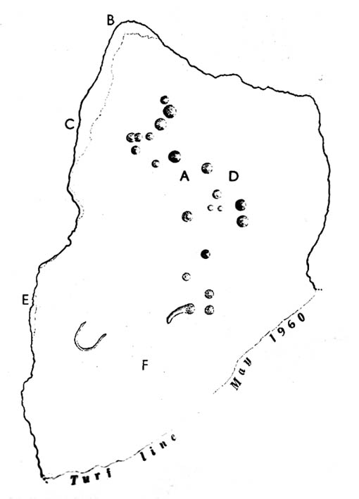
Photo by Richard StroudSketch of the carving
The carving was first discovered by Richard Stroud and I in April, 2005, amidst one of several exploratory outings to records known sites and, aswell, to keep our eyes peeled in the hope that we might find some new ones! This was the first we came across; but when we found it, just one faint cup seemed noticeable on the southern edge of the small rounded stone; but after fifteen minutes of carefully rolling back the vegetation, this very well-preserved carving was eventually unveiled before us. It’s in quite excellent condition! The most notable part of the design are the two deep cup-markings, with the topmost cup looking half-surrounded by smaller cups on its southern edge.
There is also a well-preserved, though overgrown burial cairn (probably for one person) just a few yards west of this stone. This is just about impossible to see unless the heather’s been burnt back.
Cursus (destroyed): OS Grid Reference – TF 125 078
Archaeology & History
Much of this site has unfortunately been completely destroyed. Thought by Colin Burgess (2001) to be one of the earliest cursus monuments, it was Paul Devereux (1989) who gave the clearest early description of this site,* telling:
“This site is to be found…between the village of Maxey and the River Welland, south of Market Deeping. When discovered by aerial photography the cursus was already partially destroyed… The northwest segment ‘starts’ almost on the banks of the Welland and goes southeast on a straight course to an obliterated point where a change of alignment occurred, and the cursus continues in a different direction. The total known length is 1930 yards (1.77km), and the width averages 190 feet (58 metres). The ditches themselves display subtly different orientations, but are in straight sections. The investigations of F. Pryor suggests that the northwest length of the cursus was constructed long after the southeast portion, when the latter’s ditches had become silted up (banks do not seem to have been present). The southernmost ditch of the southeastern section bisects two circular sites. Site A is particularly interesting. It occurs just east of the…change in direction, or junction of the two cursuses if such was the case.”
And such is the case, as recent discoveries have found. But before this was known for sure, Devereux wrote, that “a segment of cursus ditch emerges from this vaguely henge-like site, 450 feet in diameter, in the direction of the nearby church” of St. Peter.
The “henge-like site” described here has been defined by Oswald, Dyer and Barber (2001) as one of the enigmatic ’causewayed enclosure’ monuments – out of which emerges the other seperate alignment, the Etton Cursus, heading southeast.
References:
Burgess, Colin, The Age of Stonehenge, Phoenix: London 2001.
Loveday, Colin, Inscribed Across the Landscape, Tempus: Stroud 2006.
Oswald, A., Dyer, C. & Barber, M., The Creation of Monuments, EH: Swindon 2001.
Pennick, N. & Devereux. P., Lines on the Landscape, Hale: London 1989.
Pryor, Francis, Britain BC, Harper-Collins: London 2003.
* The OS-reference for this site is of the northwestern end of the cursus. The southeastern terminal is at TF139063.
Although very little of this cursus can be discerned on the ground, the scar of the monument is clearly visible from the air (as the GoogleEarth image shows, below). In 1989 the great archaeo-geomancer, Paul Devereux, visited the place hoping to see the monument, but said that no remains were visible at ground level, although noted how its western end is marked by the Long Bredy burial mound. Sitting amidst a mass of later neolithic and Bronze Age ceremonial remains, this old cursus aligned SE to NW. Devereux told how,
“the extended axis of the cursus…to the east, goes through a group of round barrows on the crest of a ridge on Black Down about a mile away. If diagrammatic material published by an investigating archaeologist is accurate, the alignment continues to the Nine Stones circle…immediately by the roadside a short distance west of Winterbourne Abbas.”
The monument has been measured at be at least 130 yards (100m) long and 28 yards in diameter at its greatest point.
References:
Pennick, Nigel & Devereux, Paul, Lines on the Landscape, Robert Hale: London 1989.
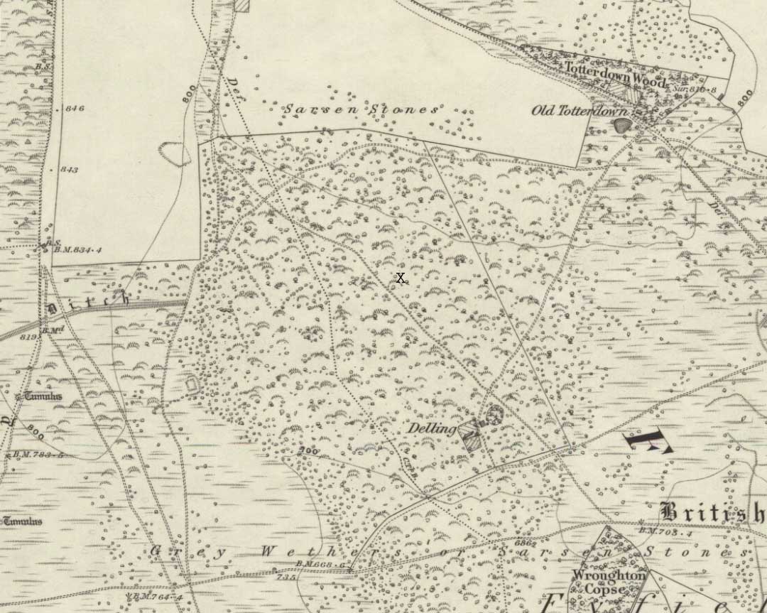
We were fortunate and taken here by the renowned local megalith authority, Pete Glastonbury – but without Pete’s help you might be ambling here and there for quite a while. It’s on the eastern side of The Ridgeway, down the slope past the stone known as The Polisher, across the flatland sea of many rocks until it begins rising again a few hundred yards east. Where a long straight embankment rises up a few feet (a boundary line), the rock’s just a few yards above it. Walk back and forth around here and you’ll eventually find it!
Archaeology & History
Lacaille’s 1962 sketch of the carving
Archaeologist A.D. Lacaille (1962) appears to have been the first person to have written about this little-known site, describing it as being “between the south-western corner of Totterdown Wood and Delling Cottage.” Here is what he described as, “a cluster of unmistakably artificial and mostly well-preserved cup-markings on the smooth south-easterly sloping surface of a recumbent sarsen.”
And from the photos accompanying Lacaille’s article, it obviously looked a decent carving as well — and so it has transpired. Lacaille (1963) briefly mentioned the carving again a year later in his lengthier essay on the nearby Polisher Stone up the slope a few hundred yards away. But then Wiltshire’s only known cup-marked stone was all-but ignored by archaeologists and left in the literary wilderness until, years later when rock art became a fad in such circles, regional archaeologists Pete Fowler & Ian Blackwell (1998) described the carving as “a cluster of several round depressions…each about two inches across”; though incorrectly ascribed it as the “southernmost example” of cup-marked stones outside of Cornwall.¹ Another rock-art student known as Mr Hobson, following his excursion to the site with the regional authority Pete Glastonbury, wrote:
“The cups themselves are very smoothed out, and fit the bill from the drawing. The horseshoe is very evident, as is the ‘slug’ mark, possibly a half-finished groove from one of the cups near the horseshoe. There are also some angular, yet serpentine (?) grooves at turf level on the south side of the stone. These look like they might be enhanced natural marks in places.”
The rock itself isn’t in its original position, having been moved from another point very close by (probably only yards away). It is sited on the edge of an old boundary line — which made me wonder whether the ‘U’- or ‘C’-shaped ingredient in the carving was a later addition, perhaps of one of the old land-owners hereabouts. The cups however, seem typical of the thousands that we find in northern Britain.
The isolation of this carving is rather anomalous. Others should be in the area but archaeo-records are silent (though the majority of Wessex archaeologists are academically illiterate when it comes to identifying such carvings). The carving may simply be the product of nomadic northerners, showing what their tribes do ‘up North’, so to speak. However, considering the tough nature of southern sarsen stones, it’d have taken ages to etch just this one stone. You can visualise it quite easily: southern tribal folk looking on, somewhat perplexed, as a northern traveller tried to convey what they etch on their stones in the northern lands, only to struggle like hell with cup-marks they’d do with ease on the softer rocks of their homelands. Wessex tribes-folk may have watched, seen the trouble their traveller had over such inane and (perhaps) meaningless carvings, and didn’t see the mythic point s/he was trying to convey…
Curious ‘U’ or ‘C’-shaped feature
Or maybe not!
The lesson with rock-art tends to be simple: where there’s one carving, others are nearby. The rule aint 100% of course — but when we were here the other day I was wanting to dart here, there and everywhere to check the many thousands of outcrop rocks that scatter this entire area. Us rock-art nuts tend to do things like that. It’s a madness that afflicts…
There were one or two stones with ‘possible’ single cup-markings on them, but I wasn’t going to start adding them to any catalogues. They were far too questionable. I was wanting something a bit more decent than that. And then, when Mikki, June, Pete, Geoff and I got to the collapsed long barrow known as the Devil’s Den a few hundred yards further down this rock-strewn sea of a valley, there was something with a bit more potential that we came across…
Folklore
In recent years this cup-marked stone has already attracted imaginative notions, with little foundation. Archaeologists Fowler & Blackwell (1998), in their otherwise fine book, think this carving was related to goddess worship, describing how,
“On Dillion Down…the Great Mother’s help was permanently invoked by patiently indenting a special stone with symbols of her potency.”
Adding that this “was a new idea brought in from the North, and Fyfield was the only place to have such a stone.” Weird! I could’ve sworn there were plenty of other rocks between here and there!
References:
Fowler, Peter J., Landscape Plotted and Pieced: Landscape History and Local Archaeology in Fyfield and Overton, Society of Antiquaries London 2000.
Fowler, Peter & Blackwell, Ian, The Landscape of Lettice Sweetapple, Tempus: Stroud 1998.
Lacaille, A.D., ‘A Cup-Marked Sarsen near Marlborough, Wiltshire,’ in Archaeological Newsletter 7:6, 1962.
¹ Along with the cup-markings atop of Devil’s Den a few hundred yards to the south, across in Somerset we had the Pool Farm example; there are a number of examples in Dorset, including the Badbury Rings carving; plus others in Devon, etc.