Achnacree, Achnacreebeag, Argyll

Chambered Cairn:  OS Grid Reference – NM 9227 3636

Also known as:

  1. Achnacridhe
  2. Canmore ID 23223
  3. Carn Ban
  4. Moss of Achnacree
  5. Ossian’s Cairn

Archaeology & History

Not to be confused with the Achnacreebeag chambered tomb a short distance to the east, Achnacree is  a site that has been made ruinous over the last 100 years, prior to which — as R.A. Smith’s (1885) illustration here shows — we had a quite grand prehistoric chambered cairn to behold. It’s still worth looking at though!
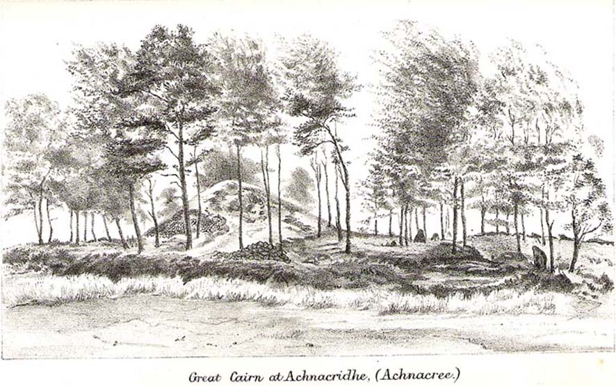
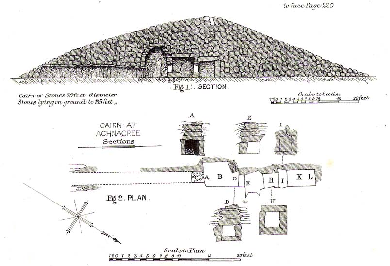
R.A. Smith’s old drawing
Smith’s early plan of the cairn

The once giant tomb is neolithic in age and nature, and was defined by Audrey Henshall (1972) as a passage grave of the Clyde Cairns group. It appears to have been built over two different periods: the earliest being when the first two internal chambers were done, “which in building technique and plan are comparable to a two-compartment Clyde-chamber and which may have been covered by a small cairn.” (RCAHMS 1974)  Much later, the long passage seems to have been added and built over the original chambers.

Although Smith (1885) and Henshall describe the large cairn, the Scottish Royal Commission (1974) entry gives the most succint archaeocentric summary of the site:

“The cairn is about 24.4m in diameter and now stands to a height of some 3.4m on the S and 4.1m on the NE, although it is said to have been about 4.6m high before excavation; it consists of small and medium-sized stones, interspersed with a few large boulders.  A low platform of cairn material, now grass-covered and about 1m high, extends round the base of the cairn and increases the overall diameter to about 40m.  The entrance to the passage is on the SE side of the cairn and is marked by four upright stones, one of which is now leaning out of position.  The central pair, set about 1.2m apart and protruding 1.3m and 0.4m above the cairn material, are the portal stones on either side of the passage, while the flanking pair may be the remains of a shallow forecourt.  The passage, which measured 6.4m in length and 0.6m in width, was constructed of upright slate slabs about 1m in height, and the roof was composed of similar slabs.  The excavator recorded that the passage was filled with stones, and these seem to indicate a deliberate blocking after the final burial-deposit.  The chamber comprised three compartments.  The outer, measuring 1.8m by 1.2m and about 2.1m in height, was constructed of upright slabs and drystone walling supplemented by corbelling, and was covered by a single capstone.  The central compartment, measuring 2m by 0.7m and 1.6m in height, was entered across a large transverse slab, and the entrance itself appeared to have been deliberately sealed with stones ‘built firmly in after the chamber had been completed.’  The sides of this chamber were formed of blocks of stone supplemented by dry-stone walling, and it was roofed by a singular capstone.  The inner compartment was entered across a sill-stone, and measured 1.4m by 0.9m and 1.7m in height.  A combination of slabs and dry-stone walling had been employed in its construction, and it was roofed by a single massive capstone some 0.4m thick.  Each side-wall was constructed of two slabs set lengthwise one above the other, in such a way that a narrow ledge was formed at their junction.  On these two ledges a number of white quartz pebbles had been deliberately deposited… Three neolithic pottery bowls were discovered in the course of the excavation — a fragmentary vessel from the outer compartment, and one complete and one fragmentary bowl from the inner compartment.”

These bowls were sent to Edinburgh’s National Museum of Antiquities soon after being found.

Folklore

Those of you into earthlights will like this one!  Also known as Carn Ban, or the White Cairn, aswell as Ossian’s Cairn, R. Angus Smith (1885:217) told how,

“it was curious…to listen to the superstitions that came out (about this tomb). One woman who lived here, and might therefore be considered an authority, said that she used to see lights upon it in dark nights.”

Another old local was truly terrified of the place, and said he would not enter this tomb for all the money in Lochnell Estate.

Regarding the various names given to the site, when Mr Smith (1885) wrote about it all those years ago, he told:

“We have often inquired the name of the cairn. The cairn really has had no definite name. Some people have called it Carn Ban or White Cairn, but that is evidently confusing it with the other cairn which we saw over the moss, and which is really whiter. Some people have called it Ossian’s Cairn, but that is not an old name, and even if it had been, we know that it is a common thing to attach this name to anything old.  We call it Achnacree Cairn, from the name of the farm on which it stands.”

References:

  1. Henshall, A.S., The Chambered Tombs of Scotland – volume 2, Edinburgh University Press 1972.
  2. Royal Commission on the Ancient & Historical Monuments of Scotland, Argyll – Volume 2: Lorn, HMSO: Edinburgh 1974.
  3. Smith, R. Angus,”Descriptive List of Antiquities near Loch Etive,” in Proceedings of the Society of Antiquaries, Scotland, volume 9, 1870-72.
  4. Smith, R. Angus, Loch Etive and the Sons of Uisneach, Alexander Gardner: London 1885 (2nd edition).

© Paul Bennett, The Northern Antiquarian 
Bryn Celli Ddu, Llandaniel Fab, Anglesey

Chambered Cairn:  OS Grid Reference – SH 50761 70185

Also known as:

  1. Bryncelli Ddu
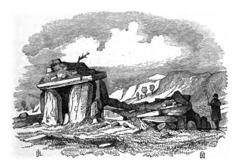
Bryn Celli Dhu in 1847

Archaeology & History

An excellent passage grave tomb that’s been described by many historians over the last two hundred years, and was subject to a fine excavation in the first half of the 20th century.  Ascribed as neolithic in origin, recent finds of human activity on the edge of the surrounding henge indicates people have been “up to things” hereby since at least 6000 BC.  Deriving its name from “the mound of the black grove,” the site as we see it today has been much restored and is so different to when it was visited by Thomas Pennant and other antiquarians.

According to an anonymously written essay in Archaeologia Cambrensis in 1847, the site was first described by Henry Rowlands (1723) where, in relation to another site, he told were,

“the remains of two carnedds, within a few paces of one another: the one is somewhat broken and pitted into on one side, where the stones had been carried away; the other having had its stones almost all taken away into walls and hedges, with two standing columns erected between them.”

A somewhat more detailed description came from Thomas Pennant a few years later.  He wrote:

“A few years ago, beneath a carnedd similar to that at Tregarnedd, was discovered, on a farm called Bryn-celli-ddu…a passage three feet wide, four feet two or three inches high and about nineteen feet and a half long, which led into a room about three feet in diameter and seven in height.  The form was an irregular hexagon, and the sides composed of six rude slabs, one of which measured in its diagonal eight feet nine inches.  In the middle was an artless pillar of stone, four feet eight inches in circumference.  This supports the roof, which consists of one great stone near ten feet in diameter.  Along the sides of the room was, if I may be allowed the expression, a stone bench, on which were found human bones, which fell to dust almost at a touch: it is probable that the bodies were placed on the bench… The diameter of the incumbent carnedd is from ninety to a hundred feet.”

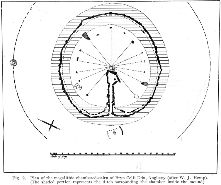
Ground-plan

But the main excavation work at Bryn Celli Ddu was done in the late-1920s by W.J. Hemp (1930) and his team, who, as usual following such digs, ended up with just as many questions about the site as they had answers!  One of the best descriptions of Hemp’s excavation work was by W.F. Grimes (1932) in an essay he wrote for the East Anglian Prehistoric Society where he gave the following detailed description of the finds:

“The cairn here was circular, with a chamber of some 160ft and an original maximum height of at least 12ft.  The chamber is a polygonal structure of large stones augmented…with dry-stone walling, entered on the northeast side by a long passage built in the same way.  Many of the stones had been dressed and in the chamber stood a single pillar which had been artificially rounded and smoothed, but which had never actually supported the capstone.

“These features had been more or less apparent for many years.  But the reparation work soon showed that this was by no means all.  In the first place, it was found that the chamber had been surrounded by four circles of standing stones.  The first of these, around the outside of the mound at its base, had disappeared, although early accounts and a single hole found in the course of the work of excavation, are evidence of its existence.  The second and third circles were found when the entrance to the passage wall was being cleared.  Here the walls of the passage were found to merge into an outer circle of large stones and an inner of smaller, set close together and elaborately packed and sunk in a ditch six feet deep and eighteen wide, enclosing the chamber in such a way that passage, chamber and circles together form a gigantic unbroken spiral, with the chamber itself as an unbroken loop in it.  The fourth and innermost circle was in the area enclosed by the ditch (which is represented on the plan by the shaded portion).  This consisted of a number of stones of various sizes, irregularly placed and in some cases inclined outwards.  Under some of them were deposits of burnt human bones.  Lines connecting these stones diametrically were found to intersect at the centre of the monument, directly behind the chamber, and here was found a slab-covered pit which contained an elaborate filling whose purpose is unexplained.  Beside the cover-stone of the pit was a second larger slab of grit, lying flat, the faces of which were covered with an elaborate and continuous pattern of spirals, scrolls and zig-zags.  The position of this stone is shown beside the central stone on the plan.  Of it purpose it can only be said that it was probably magical…

“As if the elaborate features already described thus badly were not enough, a uniform floor of purple clay was found to cover the old natural surface within the area enclosed by the ditch, and there were on the floor, in the ditch, and in many other places extensive traces of fire in the form of burnt patches, blackening and quantities of charcoal.  In addition there were outside the entrance, a line of post-holes and remains of walls suggesting the former existence of some kind of forecourt crossed by a temporary barrier.  Here also were traces of fire and of elaborate ritual.  It must be emphasized of course, that all these features, with the exception of the outer circle of stones and the forecourt, had been completely concealed by the mound, so that they were not visible once the monument was completed… Moreover…the entrance to the chamber had been closed with an elaborate blocking which suggested that once closed the chamber had not been intended to be re-opened.”

Although many questions emerged following the excavation, perhaps that relating to the chronology and evolution of the site (after its ritual use) was most important.  The site as we see it today sits within the confines of a henge monument (which should also be given an independent entry account) and once a stone circle.  And although present day field evidence is inconclusive about which came first, archaeologists like Richard Bradley, Clare o’ Kelly and others are not without opinion.  Bradley (1998) told:

“O’ Kelly argued that there had been two successive monuments on the site.  The earlier one was a stone circle, enclosed by the earthworks of the henge.  In a later phase this was replaced by a passage grave which was built over the surviving remains of the stone circle, its outer kerb being bedded in the ditch of the older monument.”

But Bradley himself doubts this for various reasons, himself interpreting,

“the sequence at Bryn Celli Ddu is to suggest that in its first phase it consisted of a circular unrevetted mound about 15m in diameter, containing a passage grave.  Around the edge of this structure was a stone circle, and beyond that there was a quarry ditch.  When the monument was enlarged, not on one occasion but twice, the passage was extended as far as the earlier ditch and a significantly larger mound was bounded by kerbstones.”

Though adding himself that there is also a trouble with this idea!  As with many other sites, Bryn Celli Ddu appears to have been aligned to the summer solstice.  This notion was first propounded by astronomer Sir Norman Lockyer (1909) in his hugely revised work on the astronomical function of megalithic sites.  It was nearly 100 years before any archaeologist got off their backside and tested Lockyer’s original proposal and found the scientist to have been way ahead of them at their own discipline.  Not unsurprisingly, archaeologist Mike Pitts (2006) was a bit slow in his gimmicky headline in British Archaeology, where he deemed Steve Burrow’s personal observation as “sensational.”  Oh how common this theme seems to be in archaeology.  Twenty years previously Miranda Green (1991) posited that the chamber alignment from Bryn Celli Ddu aligned towards “May Day sunrise” — which doesn’t seem to work.  And on a similar astronomical note, archaeologist Julian Thomas (1991) thought that five post-holes found some five yards beyond the entrance were somewhat reminiscent of the “A” holes at Stonehenge and related to some lunar alignments, thinking that:

“It seems likely that  (they) record a series of observations upon the rising of some heavenly body in order to ascertain its standstill position.”

A point that Clive Ruggles (1999) explored with a little scepticism, pointing out:

“The only possibility is the northern minor limit of the moon, and while the adjacent posts are ranged on the correct side to record the position, say, of the midwinter full moonrise in years before and after the minor standstill, many other interpretations of these posts are doubtless possible.”

There’s been lots written about this place and lots more could be added with various archaeologists showing their relative opinions about the place.  But perhaps more worthwhile is a visit to the place, later on, when the tourists have fallen back under a starlit sky…

References:

  1. Anonymous, “Cromlech at Bryn Celli Ddu, Anglesey,” in Archaeologia Cambrensis, volume 2, 1847.
  2. Barber, Chris & Williams, John G., The Ancient Stones of Wales, Blorenge: Abergavenny 1989.
  3. Bradley, Richard, “Stone Circles and Passage Graves – A Contested Relationship,” in Prehistoric Ritual and Religion, edited by Alex Gibson & Derek Simpson (Sutton: Stroud 1998).
  4. Green, Miranda, The Sun Gods of Ancient Europe, Batsford: London 1991.
  5. Grimes, W.F., “Prehistoric Archaeology in Wales since 1925,” in Proceedings of the Prehistoric Society of East Anglia, 7:1, 1932.
  6. Hemp, W.J., “The Chambered Tomb of Bryn Celli Ddu, Anglesey,” in Archaeologia, volume 80, 1930.
  7. Lockyer, Norman, Stonehenge and other British Stone Monuments Astronomically Considered, MacMillan: London 1909.
  8. Lynch, Frances, Prehistoric Anglesey, Anglesey Antiquarian Society 1991.
  9. o’ Kelly, Clare, “Bryn Celli Ddu: A Reinterpretation,” in Archaeologia Cambrensis, volume 118, 1969.
  10. Ruggles, Clive, Astronomy in Prehistoric Britain and Ireland, Yale University Press 1999.
  11. Thomas, Julian, Rethinking the Neolithic, Cambridge University Press 1991.

© Paul Bennett, The Northern Antiquarian

Devil’s Den, Clatford, Wiltshire

Cromlech:  OS Grid Reference – SU 15209 69651

Also Known as:

  1. Devils Den
  2. Dillion Dene

Getting Here

Devil’s Den, Wiltshire

When Pete Glastonbury brought us here, we walked east out of the Avebury stone circle and up the Wessex Ridgeway track.  When you hit the “crossroads” at the top of the rise a mile along, go across the stile into the grasslands for a few hundred yards till you hit the obviously-named “Gallops” racecourse-looking stretch.  Walk down for a few hundred yards till you hit a footpath on your left that takes you across and down grasslands that takes you slowly into the valley bottom.  You’re damn close!

Otherwise (and I aint done this route!), walk up the footpath straight north from Clatford village, up the small valley for about 1km.  You’ll eventually see this great stone heap in the field on your left!

Archaeology & History

I was brought here one fine day last year in the company of PeteG (our guide for the day), Geoff, June and Mikki Potts.  Twas a fine foray exploring the various prehistoric sites on the lands east of Avebury — but it was my very first venture to this site, the Devil’s Den — and a grand one it was indeed!  Standing close to the small valley bottom a couple of miles east of the great stone circle, this megalithic monument is thought to be neolithic in origin.

When H.J. Massingham (1926) came here, the day and spirit of the place must have felt fine, as he described,

“its three uprights and capstone stand forlornly in the midst of an alien sea of ploughland swinging its umber ripples to the foot of a stone isle, drifted nearly four thousand years from the happy potencies of its past.”

And, on many good times here no doubt, for many people, such feelings still hold…

A.C. Smith’s Devil’s Den
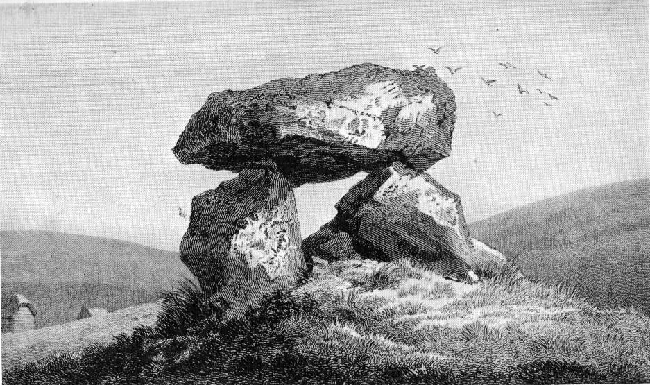
Colt Hoare’s Devil’s Den

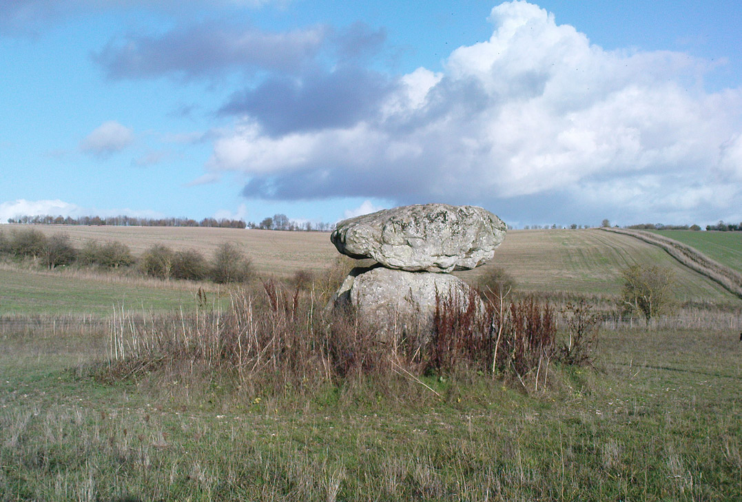
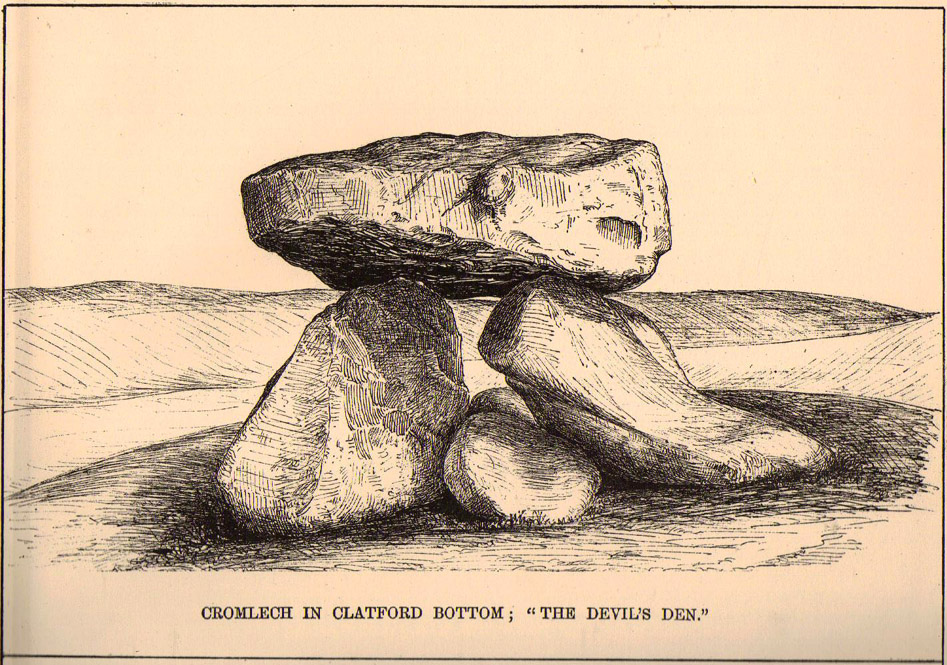
It was described by the President for the Council of British Archaeology, Paul Thomas (1976), “as a setting of four sarsen uprights with a capstone”, whereby four uprights have not been noticed here since very early times.  Not sure how old he was though!  Today the very large capstone weighing upwards of 20 tons rests gently upon just two very bulky upright monoliths.  A third is laid amidst the great tomb , overgrown and sleepy, touching one of the two uprights….

The cromlech itself seems to have once been part of a lengthy mound that was covered in earth, “about 230ft long and 120ft broad, now virtually removed by ploughing.”  On top of the great capstone are at least two cup-markings: one of them with a possible oval-shaped line carved out onto the edge of the rock (similar to the C-shaped carving on the nearby Fyfield Down cup-marked stone), but this needs looking at in various lights so we can ascertain whether it has a geological or artificial origin.

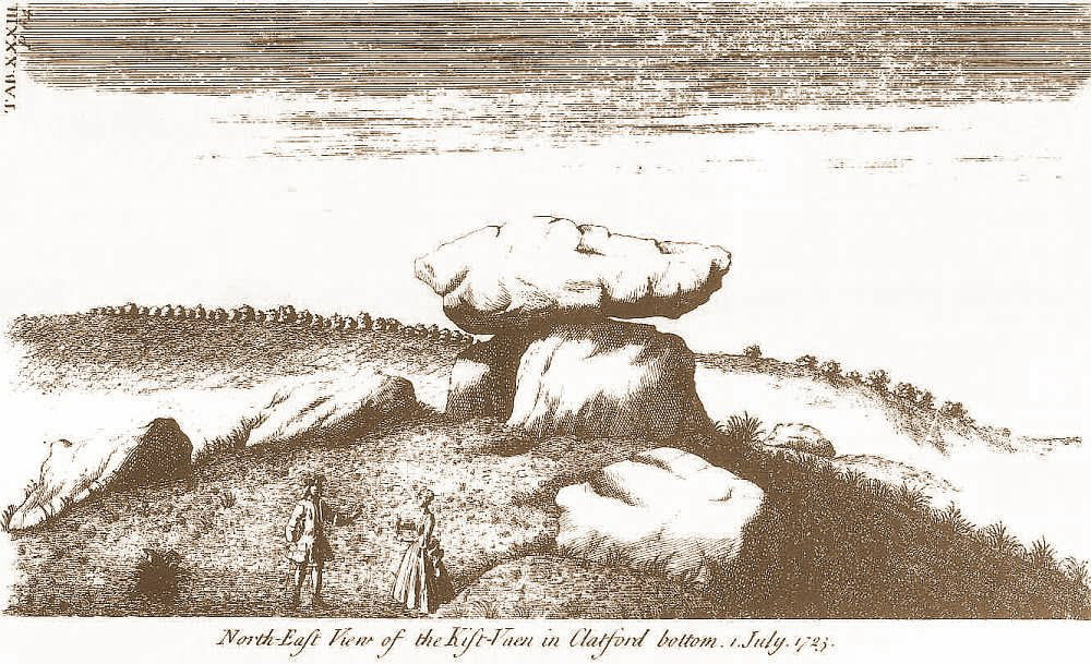
Stukeley’s Devil’s Den

Suggested by Edwin Kempson (1953) and also by Aubrey Burl (2002) and other dialect and place-name students to have originally been called Dillion Dene — “the boundary marker in the valley” — this collapsed chambered tomb has had many literary visitors, from William Stukeley onwards.  When the reverend Smith wrote his great tome in 1885, he gave an assessment of those who came before him, saying:

“This is a noble specimen of the Kistvaen: it stands erect in its original position, only denuded of the mound of earth which, I venture to say (on the authority of the Rev. W.C. Lukis and others best acquainted with these remains) at one time invariably covered them: and this massive erection of ponderous stones is known as the ‘Devil’s Den’, and offers an exceedingly fine specimen of the kistvaen to those who have not made the acquaintance of these ancient sepulchres in other counties.  It is not only perfect in condition, but of very grand dimensions; moreover, it is well known to everybody who takes the slightest interest in Wiltshire antiquities… Stukeley says very little of this kistvaen, though he gives several plates of it (in Abury Described), his only remark being: “An eminent work of this sort in Clatford Bottom, between Abury and Marlborough.”  Sir R. Hoare (in Ancient Wiltshire, North) is more enthusiastic, he says: “From Marlborough I proceed along the turnpike road  as far as the Swan public house in the parish of Clatford, and then diverge into the fields on the right, where, in a retired valley amongst the hills, is a most beautiful and well-preserved kistvaen, vulgarly call’d the ‘Devil’s Den.’  It has been erroneously described as a cromlech.  From the elevated ground on which this stone monument is placed, it is evident that it was intended as a aprt annexed to the sepulchral mound, and erected probably at the east end of it, according to the usual custom of primitive times.””

In more recent years, Terence Meaden (1999) has suggested that the Devil’s Den may actually have been a simple cromlech and never had any covering mound of earth.  In his Secrets of the Avebury Stones he described how,

“The vertical megaliths must have been set up firmly first and then, quite possibly, a mound was raised outside and between them.  A very long ramp could have been built next, along which the capstone was dragged until it lay on top of the vertical monoliths, after which both mound and ramp would be removed as far as possible.  Such an operation, if correct, would explain why the stones of Devil’s Den now stand on an obviously artificial eminence; and why the much-spread remains of a long mound oriented NW-SE, about 70 metres (230 feet) long and 40 metres (130 feet) broad, were seen and described by Passmore in 1922.  One should not necessarily assume that the stones are the remains of a chambered long barrow, although they might be.”

And you’ve gotta say that unless we have hardcore evidence to the contrary, his summary is quite possible.  However, it seems here that Meaden has simply utilised this logic to enable him to posit another reason — a “good one” he calls it — for this suggestion, i.e.,

“its capstone seems to have profiles of heads carved upon two, perhaps three of its sides; suggesting that, if the art was meant to be seen, the capstone was never covered with earth.”

Devils Den on 1889 map

Unfortunately however, these possible “carved heads” on the sides of the capstone more typify Rorscharch responses to natural geological shapes scattering rocks all over the planet.  Up North, if we were to attempt this sorta suggestion, we’d have millions of such carved heads popping up all over the place.  It’s a nice idea, but somewhat unlikely.

Folklore

The old dowser Guy Underwood (1977) was renowned for locating water lines* in and around many of England’s prehistoric sites, and the same pattern was recorded here.  He told that the Devil’s Den marked the site of a blind spring “of exceptional importance.”  He continued:

“The Devil’s Den dolmen marks the source of a multiple water line which forms a maze, marked by stones, about 200 yards to the northwest.  It terminates at a well, where two tracks cross about a mile further west.  This site is likely to have had special sanctity and would be interesting to excavate.”

Whilst the importance of water was understandable in ancient days, some other folklore attributes derive from quite different ingredients.  The common theme of “immovability” is found here, as described by reverend Smith (1885) again who, amidst other peculiarities, told the following:

“There are various traditions connected with it. I was told some years since, by an old man hoeing turnips near, that if anybody mounted to the top of it, he might shake it in one particular part. I do not know whether this is the case or not, though it is not unusual where the capstone is upheld by only three supporters. But another labourer whom I once interrogated informed me that nobody could ever pull off the capstone; that many had tried to do so without success; and that on one occasion twelve white oxen were provided with new harness, and set to pull it off, but the harness all fell to pieces immediately! As my informant evidently thought very seriously of this, and considered it the work of enchantment, I found it was not a matter for trifling to his honest but superstitious mind; and he remained perfectly unconvinced by all the arguments with which I tried to shake his credulity.”

References:

  1. Burl, Aubrey, Prehistoric Avebury, Yale University Press 2002.
  2. Goddard, E., “The Devil’s Den, Manton, Wiltshire,” in The Antiquaries Journal, volume 2, no.1, January 1922.
  3. Gomme, Alice B., ‘Folklore Scraps from Several Localities’, in Folklore, 20:1, 1909.
  4. Grinsell, Leslie V., Folklore of Prehistoric Sites in Britain, David & Charles: London 1976.
  5. Kempson, E.G.H., “The Devil’s Den,” in Wiltshire Archaeology & Natural History Magazine, 55, 1953.
  6. Massingham, H.J., Downland Man, Jonathan Cape: London 1926.
  7. Meaden, Terence, The Secrets of the Avebury Stones, Souvenir Press: London 1999.
  8. Smith, A.C., A Guide to the British and Roman Antiquities of the North Wiltshire Downs, Wiltshire Archaeological & Natural History Society 1885.
  9. Thomas, Nicholas, Guide to Prehistoric England, Batsford: London 1976.
  10. Underwood, Guy, The Pattern of the Past, Abacus: London 1977.
  11. Wright, Joseph, English Dialect Dictionary – volume 2, Henry Frowde: London 1898.

* Those people who allege they can dowse will always find water in their first few months, if not years, of sensitivity.  There is a pattern nowadays of people using dowsing tools and, when the rods cross (or whichever accessory they get their reactions from), they allege they are connecting with unknown energies, ley lines and other such items; but this is simply incorrect. The primary dowsing response is water (life-blood) and it takes much practice over long periods of time to even begin isolating leys or other occult phenomena.

© Paul Bennett, The Northern Antiquarian

Lyneham Barrow, Ascot-under-Wychwood, Oxfordshire

Long Barrow:  OS Grid Reference – SP 2975 2107

Getting Here

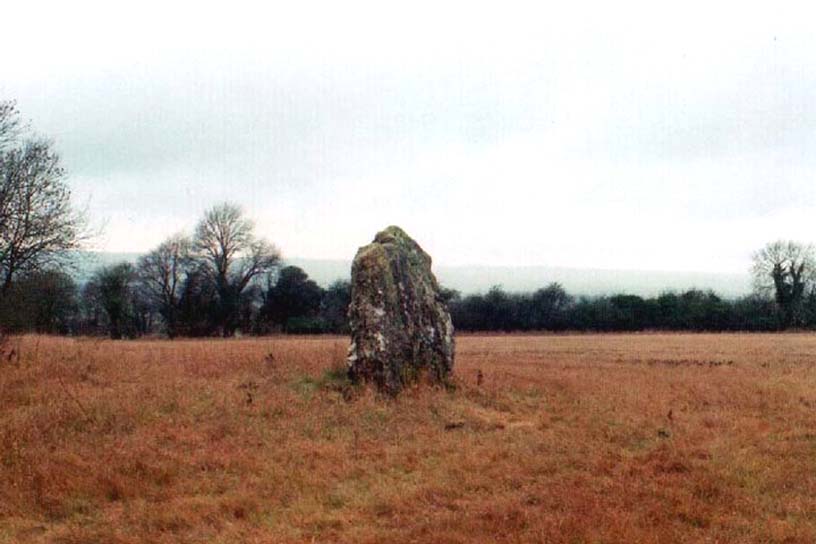
Lyneham Barrow stone

Pretty easy really.  From Shipton-under-Wychwood take the A361 road north (to Chipping Norton) for just over 2 miles.  You’ll pass the TV mast on your right and then a small country lane sign-posted to Ascott-under-Wychwood.  Go past this and then stop at the next right-turn a half-mile further up the road.  The barrow is about 100 yards before this turning, in the hedgerow, on the left-hand side of the road!

Archaeology & History

This once great and proud neolithic monument is today but a shadow of its former self.  Described by various antiquarians and archaeologists over the years, O.G.S. Crawford (1925) included it in his fine survey, telling:

“The barrow is between 160 and 170 feet long and stands in two fields on the west side of the Chipping Norton and Burford main road… In the northern field, at the NE end of the barrow, stands a single upright stone, 6 feet high, 5 feet broad and 1 foot 6 inches thick.  This stone is stated to be buried three feet deep in the ground and its height is given by Conder as 10 feet 6 inches.  When visited October 18, 1922, a large piece of the top had been broken off, but replaced in position.”

This damage was reported around the same time and described in the early “Notes” of The Antiquaries Journal by a Mr A.D. Passmore (1925), who wrote:

“About 30ft from the north-east end of this long barrow stands a large monolith now nearly 6ft above ground…and roughly 6ft wide and just under 2ft thick, of local stone.  At the top is an ancient and natural fissure extending right across the stone and penetrating some way downwards obliquely.  Early in 1923, either by foul play or natural decay, another crack appeared spreading towards the first about a right-angle, the result being that a large piece at the top of the monolith became detached.  Such an opportunity of mischief was speedily taken advantage of and the piece of stone, weighing over 4 cwt, was pushed off and fell to the ground.  In August 1924 the owner of the land, his man, and the writer spread a bed of cement and hoisted up the large broken mass and relaid it in its bed.”

But even in their day, the tomb had already been opened up and checked out, by a Lord Moreton and a Mr Edward Conder, in 1894 no less!  Conder’s account (1895) of the inside of this ancient tomb told:

“There were found (1) a chamber at right angles to the long axis of the barrow; on the south-eastern side of the barrow were two uprights, 4 feet 2 inches by 2 feet 1o inches, and 1 foot 9 inches by 2 feet 8 inches.  At the north-western end of the chamber were two uprights set with their long faces (edges?) abutting.  On the surface-line at the level of the base of the barrow were traces of paving and fragments of bone, pottery and charcoal.  (2) Chamber, a little south of the south-east corner of No.1,  slightly above the ground level.  It was formed of three uprights, on the north, east and west sides respectively, and a paving slab with a perforation 4 inches in diameter.  At the north-eastern end of the barrow was a ridge of large ‘rug’ stones up to 8 feet long, 5 feet wide, and 2½ feet thick, terminating in a standing stone…10 feet 6 inches high…buried 3 feet below ground level.  At the southwest end was a standing stone, 4½ feet by 3 feet by 11 inches thick, in a horizontal position lying east and west, 2 feet below the surface. At various points were found skulls and human and animal bones and hearths, with no indications of date, and (as secondary interments) two Saxon graves.”

Today, poor old Lyneham Barrow is much overgrown and could do with a bittova face-lift to bring it back to life.  But I wouldn’t hold y’ breath…..

Folklore

At the crossroads just above this old tomb, the ghost of a white lady is said to roam.  And at the old quarry on the other side of the road a decidedly shamanistic tale speaks of an old lady who lived in a cave and guarded great treasure!  Her spirit is sometimes seen wandering about in and around the fields hereby.

References:

  1. Bennett, Paul & Wilson, Tom, The Old Stones of Rollright and District, Cockley: London 1999.
  2. Brooks, J.A., Ghosts and Witches of the Cotswolds, Jarrold: Norwich 1992.
  3. Conder, Edward, “An Account of the Exploration of Lyneham Barrow, Oxon,” in Proceedings of the Society of Antiquaries, volume 15, 1895.
  4. Crawford, O.G.S., Long Barrows of the Cotswolds, John Bellows: Oxford 1925.
  5. Dyer, James, Discovering Regional Archaeology: The Cotswolds and the Upper Thames, Shire: Tring 1970.
  6. L.V. Grinsell’s Ancient Burial Mounds of England, Methuen: London 1936.
  7. James, Dave, “A Brief Foray into Oxfordshire,” in Gloucestershire Earth Mysteries 14, 1992.
  8. Passmore, A.D., “Lyneham Barrow, Oxfordshire,” in Antiquaries Journal, 5:2, April 1925.
  9. Turner, Mark, Folklore and mysteries of the Cotswolds, Hale: London 1993.

© Paul Bennett, The Northern Antiquarian

North Hill, Samson, Scilly Isles, Cornwall

Chambered Cairn:  OS Grid Reference – SV 877 131

Archaeology & History

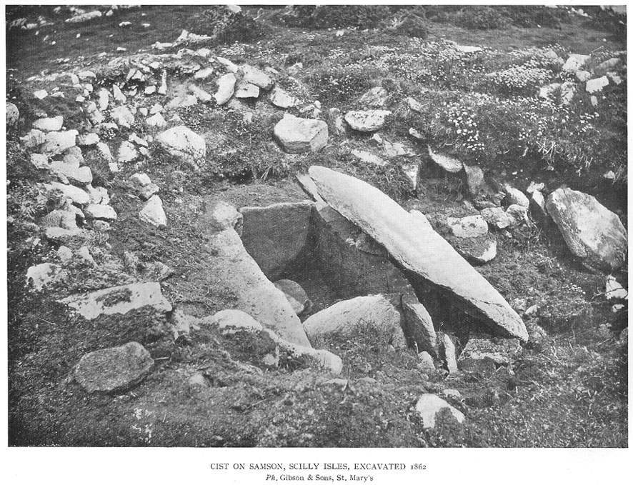
Early photo of the North Hill tomb (Crawford 1928)

On the north side of Samson island there are several chambered tombs and cairns scattered around the edges of aptly-named North Hill; but the one illustrated here was one of the first to be excavated in 1862-3.  Although O.G.S. Crawford (1928) wrote about the site in his essay on Cornish cists — from where this old black-and-white photo of the site has been taken — it was described in much greater detail in Borlase’s (1872) archaeological magnum opus of the day.  In his time, this now much-denuded burial site had all the outer hallmarks of being a large tumulus.  This was described in some detail in a paper written by one Mr Augustus Smith (read at a Meeting of the Royal Institution of Cornwall in May, 1863) who was fortunate enough to be one of the first people to unearth this great tomb and find the site untouched since it had been laid, thousands of years earlier.  Citing extensively from Smith’s notes, Borlase told:

“The Barrow…is situated with four or five others, mostly rifled on the…high ground at the northern end.  “The mound, in its outer circumference, measured about 58 feet, giving, therefore, a distance of near upon 30 feet to its centre, from where the excavation was commenced.  For about 18 or 20 feet the mound appeared entirely composed of fine earth, when an inner covering, first of smaller and then or large rugged stones, was revealed.  These were carefully uncovered before being disturbed, and were then one by one displaced till a large upright stone was reached, covered by another of still more ponderous dimensions, which projected partially over the edges of the other.  At length this top covering, of irregular shape, but measuring about 5 feet 6 inches in its largest diameter, was thoroughly cleared of the superincumbent stones and earth, and showed itself evidently to be the lid to some mysterious vault or chamber beneath.”  On the lid being removed, there was “disclosed to view an oblong stone chest or sarcophagus beneath” on the floor of which, “in a small patch,” “a little heap of bones, the fragmentary framework of some denizen of earth, perhaps a former proprietor of the Islands—were discovered piled together in one corner.

“”The bones were carefully taken out, and the more prominent fragments, on subsequent examination by a medical gentleman, were found to give the following particulars: – Part of an upper jawbone presented the alveolæ of all the incisors, the canines, two cuspids and three molars, and the roots of two teeth, very white, still remaining in the sockets.  Another fragment gave part of the lower jaw with similar remains of teeth in the sockets.  All the bones had been under the action of fire and must have been carefully collected together after the burning of the body.  They are considered to have belonged to a man about 50 years of age…

“”The bottom of the sarcophagus was neatly fitted with a pavement of three flat but irregular-shaped stones, the joints fitted with clay mortar, as were also the insterstices where the stones forming the upright sides joined together, as also the lid, which was very neatly and closely fitted down with this same plaster.

“”Two long slabs, from seven to nine feet in length, and two feet in depth, form the sides, while the short stones fitted in between them make the ends, being about 3½ feet apart, and to fix which firmly in their places, grooves had been roughly worked in the larger stones.”  The paving stones had been “embedded immediately upon the natural surface of the granite of which the hill consists.”

References:

  1. Borlase, William Copeland, Nænia Cornubiæ, Longmans Green: London 1872.
  2. Crawford, O.G.S., “Stone Cists,” in Antiquity Journal, volume 2, no.8, December 1928.

© Paul Bennett, The Northern Antiquarian