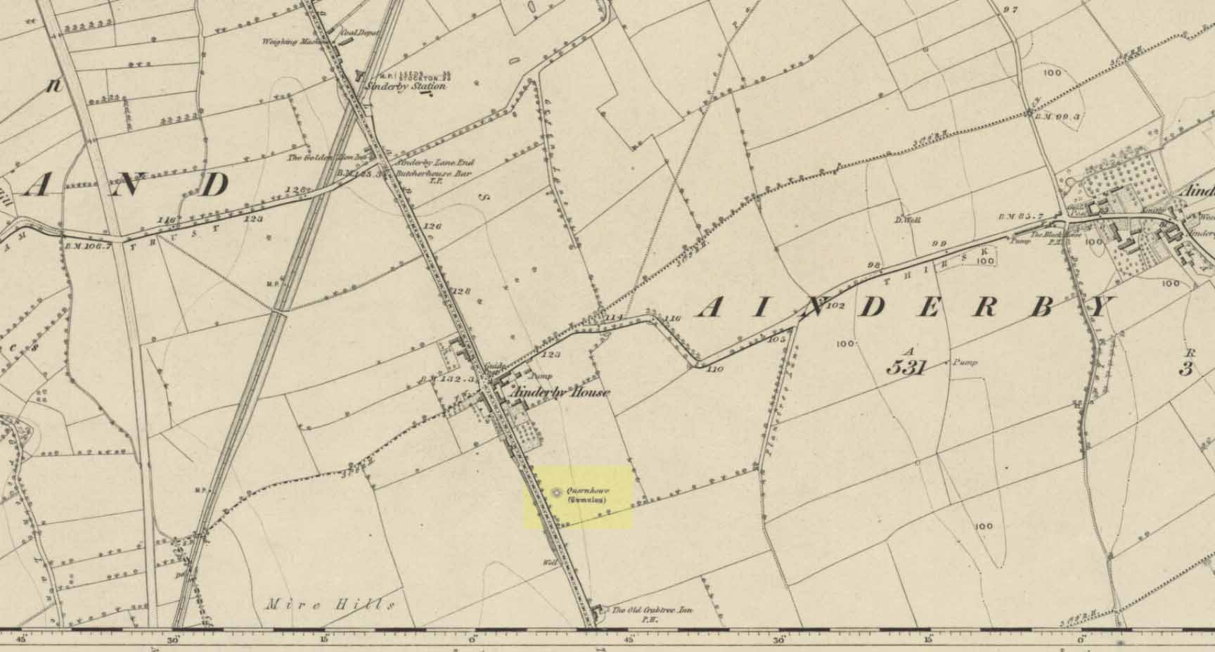
Long since destroyed by the self-righteous advance of the Industrialists, this was a pretty impressive-looking tomb according to the account of D.M. Waterman (1951). Found between the villages of Ainderby Quernhow and Kirklington, right at the side of an important prehistoric trackway—later used by the Romans and known as Leeming Street (on what is now the A1 motorway). Waterman cited it as being “of primary importance in prehistoric times” as it stood on the great plain between the three great henges of Thornborough to the north and those on Hutton Moor to the south, accompanied by a number of other tumuli nearby.
Quernhow tomb on 1856 OS mapThe excavated monument
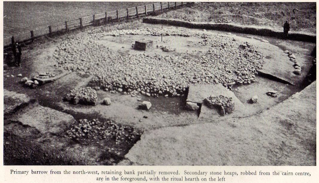
When Waterman and his team arrived here, the barrow “appeared as a low-spread mound, about 3ft in elevation, the exact limits of which were difficult to define,” due to large parts of it being covered over in mud that’d been dumped there by the local land-owner, aswell as erosion due to other farming or industrial activity. But once the archaeologists had stripped the centuries of soil from the damaged surface of the monument, a most impressive site emerged! At the heart of this great burial mound was found “an imposing stone cairn, more or less flat-topped and with a circular constructed face.” He (1951) continued:
“The material of the cairn was composed of cobbles or boulders, all of local geological origin, ranging in size from a few inches up to a foot in diameter or more. A stone considerably larger in size was occasionally encountered , the largest found measuring 23in by 20in and from 3in to 5in in thickness. The stones were heaped up without any deliberate attempt at producing a stable structure and used indiscriminately, irrespective of size or shape, although there was a tendency for the larger stones to occur towards the perimeter of the cairn. Since the cairn itself was built to a flat surface, and the underlying barrow-mound assumed a saucer-shaped profile, the cobbles perforce increased in depth towards the cairn face; at the very centre they were laid one, occasionally two deep, at the face three or four deep, although irregular size and placing precluded any consistency whatsoever in the work. The standard of the building in fact differed considerably throughout the structure. On the northeast and northwest the facing-stones were quite carefully laid, standing to a height of 22in, the work becoming increasingly shoddy towards the south where the construction had so deteriorated that whole sections of the facing had fallen bodily away from the cairn mass, slipping down the tail of the underlying mound…”
Plan of Quernhow
In the middle of the large cairn were found four small pits and a number of small cremations in and around them. There were also found the usual broken remains of pottery, human bones, charcoal, foods vessels and burnt pieces of oak and other vegetation. Near the centre of the cairn was a curious “four poster” of upright stones, “about 1.4ft long and rather less in breadth and thickness (which) suggest, from consideration of their obviously deliberate and careful placing, some significant function in burial ritual.” The four corners of these stones were close to the cardinal points: north, south, east and west.
References:
Waterman, D.M., “Quernhow: A Food Vessel Barrow in Yorkshire,” in Antiquaries Journal, volume 31, 1951.
This is an intriguing find inasmuch as cup-marked stones are rare in this part of the British Isles. Antiquarians have noted examples of such carvings in the Cornish townships of Davidstow, Delabole, Portreath, but very few others are known about. But in the once-impressive Tregulland Burrow barrow that was found here on the south-side of the road a few hundred yards up from Cold Northcott, just next to the old township boundary line, as many as eighteen carved stones were unearthed!
Fig.2
They were all found inside different sections of the barrow, which was built on top of an earlier cairn structure, which appears to have been built upon an even earlier concentric ring of upright wooden poles. The cup-marked stones appear to have been introduced, or etched, around the time when the cairn structure was laid on top of the concentric ring of stake-holes. This “tradition” of adding cup-marked stones to cairns is a feature found at a number of sites in the northern lands of Yorkshire, Northumbria and across the Scottish counties, but such a celebrated event as this in the far southwest is highly unusual! (although the custom is pretty universal and is found, not only in the UK, but in many parts of the world).
Fig.3Fig.4
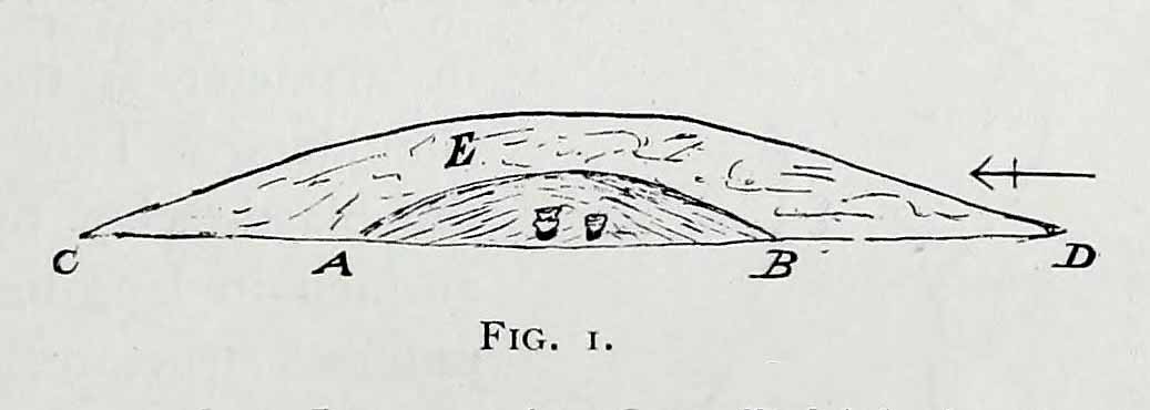
In Paul Ashbee’s (1958) excellent essay on this prehistoric tomb, he described the carvings at some considerable length — which is unusual for an archaeologist of that period — noting them as the “cup-marked and ornamented stones”. I hope that people won’t mind me repeating his lengthy notes on the relevant carved stones found in the tomb, the largest of which was on a big slab near the middle of the cairn that possessed cup-markings “and an ‘eyebrow’ motif”,* (figure 1, above) as he called it. He described the respective carvings as follows:
“From the Cairn-Ring:
1-2. A hog-backed outlined slate slab (figure 1, above). The bottom has a straight worked edge which suggests that the form was deliberate. On the inner face are four close-set cup-marks, and an ‘eyebrow’ device which has been made around a natural flaw, whilst the outer half has been formed by pecking and bashing to remove an appropriate amount of the laminated slate structure to form a depression. On the outer face there are four widely set cup-marks, one being connected by a channel to the edge of the slab…
3-4. A roughly rectangular slate slab. The upper face bears two cup-marks, one much smaller than the other, together with one abortive cup-mark, the lower a single cup-mark. Four perforations had been used to remove this slab from a parent block, the halves of these perforations gracing the upper edge. The slab was incorporated in the upper part of the cairn-ring material stacked against the largest of the sub-megalithic blocks of the cairn-ring.
5. The slab is hog-backed in outline, resembling No.1 above in general form. On the upper face, at a right-angle to the straight bottom edge, a channel had been produced by pecking, the marks of a pointed instrument being clearly discernible at the bottom of the channel. This channel extends almost from edge to edge of the slab, being narrow at the bottom and then expanding, being thus wider and then gradually tapering. Were it not asymmetrical it could be considered as a dagger representation.
6. A small block of roughly pentagonal outline, one side being irregular. The device it bears has been made by pecking an outline and removing the intervening laminated slatey rock. Found at the base of the cairn-ring on the south side.
7. A weathered pillow-like lump of a coarse sandstone-like rock. The plane face bears at least seven small ‘cup-marks.’ On other sides there are more weathered and uncertain marks which may well be natural. It was found surmounting, in a central position, the faced walling on the western side of the cairn-ring. Dr F.S. Wallis reports that: “This is evidently a sandstone rock with a large amount of quartz. This is a very generalized rock and I am afraid that it is not possible to tie it down to any particular part of Cornwall. The rock is much weathered and, judging from the print, I should say that the pits are entirely natural. Such a rock would hardly contain fossils and thus the pits could not have an organic origin.”
8. A roughly rectangular slate slab with opposing ‘cup-marks’ broken through before complete perforation. In addition there is a single cup-mark on the upper edge. (see figure 2) It was in the banked stones on the western side of the cairn-ring.
“From the soil bank:
1. An even, rectangular slab bearing a group of three cup-marks in one corner, and single cup-marks in two other corners. (see figure 3) From the outer cup-marks of the group run two channels. A channel runs from one of the solitary corner cup-marks. It was found, cup-marks and channels uppermost, almost exactly above the satellite cremation trench-grave.
2. A roughly triangular slab, bearing on its upper face a single centrally set cup-mark. Found by the cairn-ring in the eastern quadrant.
3. A small slab, of pentagonal outline, bearing a single shallow cup-mark. Found by the cairn-ring in the eastern side.
4. A thin U-shaped slab which has been battered into shape by edge chipping. A concavity has been made along the upper edge.
“From the ditch infilling:
5. A tough, quartz-veined slab with a shallow battered cup-mark. From the western side of the barrow.
6. A small, tough, even, rectangular piece of slate, bearing an abortive cup-mark. From the western side of the barrow.
7. A thin piece of slate bearing a small cup-mark set at a point where laminae of slate have left the piece. From the eastern side of the barrow.
“Unstratified:
All the “unstratified” cup-marked slabs recovered from the central disturbances, both recent and earlier, may well be derived from the destruction of the central grave arrangements.
8. A thick lozenge-outlined slab bearing one large cup-mark, and one smaller set side-by-side. (figure 4, above)
9. A roughly square-outlined slab with two cup-marks of even size set across one diagonal. (figure 5, below) One cup-mark has a smaller one close by it.
10-11. Irregular pieces of thin slate, bearing traces of perforations on their edges, one bearing cup-marks.
12. A roughly triangular slab bearing an ? unfinished cup-mark.
13. An even hexagonal slab that appears to have been, by edge trimming, worked into this form.”
Fig.5
The prolific collection of cup-marked stones in this once-impressive monument would probably indicate that the character buried here was of some significance to the local people, both to those who knew him and, evidently, in the subsequent mythologies surrounding the site (click here for the details of Tregullan Burrow barrow if you wanna know the archaeology and structure of the site). And although we find, statistically speaking, a lacking of other cup-markings in this region, it’s more than likely there are others that are hiding away amidst other old tombs and rocks…
References:
Ashbee, Paul, “The Excavation of Tregulland Burrow, Treneglos Parish, Cornwall,” in Antiquaries Journal, volume 38, 1958.
* the eyebrow motif description was used by a number of archaeo’s for sometime following publication of O.G.S. Crawford’s book, The Eye Goddess, to which the Antiquity Journal editor speculated some cup-and-rings may have owed their origin.
Crowned by a clump of trees (planted in 1740), this hilltop site is one of the more impressive of a number of tombs hereby, with its nearest other neighbour being 70 yards southeast of here. One of Dorset’s early tribal meeting places (Anderson 1934), the tomb was illustrated on Isaac Taylor’s 1765 map of the region and was dug into in 1858 “on the orders of a local magnate” (Marsden 1999), damaging some substantial portion of the tomb. Of this, craniologist and antiquarian John Thurnam was most displeased; for in his description of the opening of Culliford Tree he wrote:
“A wide trench had been dug through it one side, from the summit and the rubble which had been thrown out had not been replaced… Another subject of regret was the fact that though, as we were told by the neighbouring rustics, human remains, with pottery and certain other relics, were found in the barrow, no authentic account of the exploration had, so far as we could learn, been put to print.”
Leslie Grinsell (1959) found the same trouble in his assessment of this site; and the Royal Commission (1970) lads could only describe the site thus:
“Large trench on south and top almost certainly dug in 1858 when four secondary extended inhumations, one with necklace of amber and two gold-plated beads, and cremation with incense cup in collared urn, were found.”
However, it seems that the necklace and gold-plated beads have been “lost” — i.e., someone has them in their own private collection somewhere!
Folklore
This is one of very few tombs in this part of the country where we find the tradition of fairy music. Grinsell (1959) told that:
“The Culliford Tree barrow, formerly the meeting place of the Hundred of Culllingford Tree, is also known as the Music Barrow from the belief that music could be heard beneath the mound by those who listened at the apex at midday.”
References:
Anderson, O.S., The English Hundred-Names, Lunds Universitets Arsskrift 1934.
Marsden, Barry M., The Early Barrow Diggers, Tempus: Stroud 1999.
Royal Commission on Historical Monuments, An Inventory of Historical Monuments in the County of Dorset – Volume 2: South-East, Part 3, HMSO: London 1970.
Warne, Charles, Celtic Tumuli of Dorset: An Account of Personal and other Researches in the Sepulchral Mounds of the Durotriges, Smith: London 1866.
This rather delapidated spring of water (there are actually two springs here) marks the western edge of the parish boundary, just on the south-side of the A368 road towards Ubley, on what Phil Quinn (1999) described as “a neglected triangle of shrubby ground.” Its name derives from once being associated with a prehistoric tomb, or barrow, as the associated field-names of Barrows Orchard and Barrow Cross here indicates. Sadly however, all remains of whatever tomb there once was appears to have gone. Aerial imagery shows what may have been two or three barrows in the said field.
Folklore
A haunted site: the folklore here is akin to banshee-lore and similar mythic figures. The fact that it marked the old boundary line between here and Ubley may have something to do with it. Quinn (1999) says how,
“Local folklore states that the well was haunted by the ghost of a woman washing cabbages”!
But this vegetative lore is likely a mistranslation of a local dialect word. Precisely what the spirit was supposedly ‘washing’ seems to have been lost in translation.
References:
Quinn, Phil, The Holy Wells of Bath and Bristol Region, Logaston: Almeley 1999.
Tumulus (destroyed): OS Grid Reference – TQ 163 703
Archaeology & History
This is one of very few prehistoric tombs that are known about from the London region and — surprise, surprise! — very little is left of the place. No surprise really. It appears to have first been explored soon after Queen Victoria came to the throne
“A barrow on the south side of Sandy Lane was excavated in 1854. It revealed some much disturbed burials, some flint tools and part of a bronze dagger.” (Ching & Howe 1980)
There were in fact the remains of three people found here: one at base level; the other just below the top; and the third body comprised remains that appear to have been buried just beneath the surface. The tomb was a big thing aswell — being nearly 100 feet across and more than 10 feet high. Pity there’s little to be seen of it today…
References:
Ching, Paddy & Howe, Ken, Teddington – As it Was, Hendon: Nelson 1980.
Gordon, E.O., Prehistoric London– Its Mounds and Circles, Covenant: London 1946.
Merriman, Nicholas, Prehistoric London, London Museum 1990.
Spence, Lewis, Legendary London, Hale: London 1937.
Various ways up this old hill, visible from all angles it seems. I came up via the housing estate near where us friend lives, near Bare Lane Station, through the houses and up the footpath. But you can just as easy (if not easier) walk up from the country lane and fields beneath its eastern side. Much nicer!
Archaeology & History
Torrisholme Barrow
As many northerners will tell: gerrin information from the Lancashire archaeologists about prehistoric sites is troublesome (must be Southerners running the show!). There’s tons of stuff in this good county, but archaeo-info is pretty poor on the ground. This great old tomb for example, is designated as a “round barrow” on the Lancashire County Council monuments and records listing, but there’s no other info telling when it was dug, who by, the size of the tomb, what was found here, etc. Pretty poor to be honest (c’mon chaps – get yer fingers out!). The best info on-line comes from the more dedicated amateur enthusiasts.
A local historian told us that there was nowt up here, but my nose told me otherwise — so up we tramped! It was pretty obvious once we’d got to the top here, that some ancient mound had been built up.
“This has all the hallmarks of a tomb,” I said.
Torrisholme Barrow, looking SW
The spirit of the ancestor herein (whoever s/he was) had excellent views and flights to numerous important hills 360° all round here. A perfect place for a tomb! And when we returned into the Darklands of our Yorkshire abodes, we found this notion to be true. Marked on early OS-maps as a tumulus, next to the tell-tale giveaway route of Barrow Lane, there are passing mentions of it in a couple of old local history books I’ve come across, but I’ve yet to find much more about it. It’s a fine mound and of decent size, well worth checking out if you’re in the area. Once I get more details of the archaeological finds from here, I’ll add the data to TNA (but based on past performances and responses from Lancashire archaeo’s, I wouldn’t hold your breath…)
And for any Morecambe historians who might be able to find more: what — if anything — is known of the ‘Fartle Barrow’, now swallowed by the encroachment of the sea, just a few hundred yards west of here?
Folklore
In days of olde, this site was an old moot or meeting hill: one of the northern Law or council meeting hills. Quite how far back this gathering tradition up here goes, aint known. We do know however that there was a christian tradition enacted here, at Easter, of local church doods taking a cross up the top of the hill (does anyone know the story behind the old Cross Hill, half-a-mile south of here?). There’s obviously quite a lot more pre-christian activities occurrent round here than has been previously thought.
The faded remains of this old burial mound can vaguely be seen just off the right-hand (east) side of the B1248, across the road from the track which leads down to Burdale North Wold farmhouse, between Fimber and Wharram-le-Street.
Archaeology & History
Known as Towthorpe Barrow No.1 in the Mortimer survey (1905), there are a number of prehistoric tombs and other remains close to this site (which will be described on TNA as time goes by). Some of you might think the lengthy description here a little unworthy, but I believe the extensive archaeological notes on this site by an archaeological legend, J.R. Mortimer, is a good indicator of the dedication and interest to which he gave each and every tomb that he opened (this’ll be the first of many). His slightly edited account told:
“This mound is situated near the centre of the (Towthorpe) group, close to High Towthorpe. Here the green lane…is crossed by the high road from Malton (B1248), through Wharram-le-Street… Part of this road, for some distance south and north of the barrow, is called ‘High Street’ by the old inhabitants of the neighbourhood…
“On 4 May, 1863, the writer, with the assistance of R. Mortimer and two workmen, commenced to open this mound. It was the first British barrow he had the pleasure of examining. A trench 10 feet wide was cut across its centre from the northern to the southern margin…
“The upper portion E, to a depth of 16 inches, consisted chiefly of the surface soil of the neighbourhood, the bottom part of which was reddened as if by the action of fire. Close below this was a stratum of wood and ashes and other dark matter, 2-3 inches in thickness; and then a lenticular bed of tough drab-coloured clay, 29 feet in diameter, and 12-14 inches thick in the centre, gradually thinning towards the circumference. The upper part of this bed of clay, which was in contact with the stratum of wood ashes, was reddened by fire; its under surface had a similar appearance and rested upon what seemed to be a second stratum of burnt and decayed matter, 2-3 inches in thickness, similar to that already described. The clay forming this lenticular bed contained numerous small fragments of grey flint, characteristic of the chalk of the neighbourhood. It must have been obtained from one of the valley bottoms (either Burdale, Wharram-le-Street or Duggleby), in which are exposures of the Kimeridge clay. In these places, angular pieces of flint and chalk crumble from the hillside, and mix with the clay, imparting a greyish colour to it. This is especially the case at Burdale, where there is a fine spring at the base of the chalk, and a small pond resting on the Kimeridge; and it is probably from this place that most of the clay for the construction of this barrow was obtained. It is not easy to explain the method by which the clay was transported, but several tons had evidently been used in this case. Many other instances in which material from a distance has been used in the erection of the barrows of this neighbourhood are recorded in (the Yorkshire Wolds).
“In the centre of the mound, at the base of the lenticular bed of clay and below the ashes (which probably represent the residue of a funeral pyre) stood two food vases, close together, and near to these, decayed bones (the remains of a human body) and a chipped flint. The smaller and more ornamented vase was situated to the south of its fellow. It measures 4.5 inches in neight, 5.5. inches in diameter at the top, and about the same across the shoulders. The ornamentation had been impressed on the plastic clay by a thin square-ended tool, about half-an-inch in length, which showed in the impression of a fine notched structure, and was equally divided into ten ridges about the size of the indentations on the milled edge of a shilling, and almost as truly cut. In the lower groove which runs round the vase are four pierced projections.
“The other vase is about 5 inches high and about 6 inches in diameter at the top and across the shoulders. Three encircling lines of short vertical cuts, rudely and apparently hastily made, previous to baking the vase, represent its entire ornamentation.
“During the excavation we collected from the material of the mound a dozen hand-struck flint flakes of various sizes, and a small splinter from the cutting-edge of a green-stone celt.”
Mr Mortimer returned to do further excavations here on Christmas Eve and Christmas Day in 1865, with the hope of finding more — but apart from a finely-cut knife made of black flint, nothing else was located. This was the first of Mortimer’s hundreds of diggings into the tombs and dykes of East and North Yorkshire.
References:
Marsden, Barry M., The Early Barrow Diggers, Tempus: Stroud 1999.
Mortimer, J.R., Forty Years Researches in British and Saxon Burial Mounds of East Yorkshire, A. Brown: London 1905.
From Askwith village, at the T-junction, go up Moor Lane, taking the left turn up Moorside Lane about half-a-mile up and on the track to Moorside Farm and then onto Top Moorside Farm. Take the path past the farm up onto the moor, then bear right up the small track that heads up onto the small Hollin Tree Hill. As you go up the track, watch out for the small grassy depression to the right; and hereby head into the grasses on your right. You’re close!
Graeme Chappell was the first to rediscover this carving in the early 1990s when we were up pottering about on these and the adjacent moors, looking for any previously undiscovered prehistoric relics. We found quite a lot! The carving here is nowt special to look at really, but the cups can be seen quite clearly. It’s a rather large stone on the western edge of the hill with at least seven or eight cup-marks carved across its upper surface. Boughey & Vickerman (2003) later described it as “large, fine quartz sandstone rock with surface sloping slightly down into (the) hillside. Seven or eight cups, two particularly sharp.” There’s a possible line running between two of the cups, visible when lighting conditions are right — though we aint sure whether it’s artificial or not.
References:
Boughey, Keith & Vickerman, E.A., Prehistoric Rock Art of the West Riding, WYAS 2003.
To find this, head for the line of old grouse-butts which run north-south, a few hundred yards west of the Askwith Moor Road. Just before y’ get to the one nearest the bottom of the line, frobble about a bit. If by any chance you end up at the Woman Stone carving, walk back up the slope until you’re on the level. Not far ahead of you are the upright stone remains of a grouse-butt. This carving is just a few yards away. You’ll find it.
This was another carving found on one of the many forays of Mr Chappell and I when we were young, sometime in 1993. A short while after, Graeme wrote to Edward Vickerman to inform him of the find, which ended up in their rock art survey a decade later.
It’s another one of those simple designs: what seems like at least 5 cup-markings on a small rounded rock, with two of them linked together by a groove — possibly natural, possibly man-made — though there may in fact be seven or more cups etched onto its upper surface. It’s difficult to tell. It gives you the impression that its present position isn’t its original one and is suggested by Boughey & Vickerman (2003) to have been “moved from pipeline?” close by. It may even have been dug out and cast here, possibly once being a part of a cairn. In the Boughey & Vickerman survey they give its OS-coordinate as SE 17163 50527 – and describe it as a “medium-sized, free-standing rock of fine grit. Five cups, some perhaps natural.” When Richard Stroud and I visited the site, he found the GPS coordinate was SE 17162 50530; and we have to say that instead of describing it as a free-standing rock, it’s a movable stone (though it’d take a bit of effort), that may once have been part of a larger monument.
References:
Bennett, Paul & Chappell, Graeme, Personal Communication, 1993.
Boughey, Keith & Vickerman, E.A., Prehistoric Rock Art of the West Riding, WYAS: Wakefield 2003.