Follow the same directions for reaching the Baldwin Stone. From here, with your back to the wall, face the small remnants of Robin Hood’s Wood and walk straight to where the game-keeper’s stuff is in the trees 150 yards straight in front. Go through the small copse and out the other side, in a straight line for another 70 yards. This stone’s mainly covered over with vegetation (and we covered most of it back over again) so you might have trouble finding it. But with patience and a good nose, you’ll find it hereabouts!
Archaeology & History
Robin Hood’s Wood Cup-Marks
Another previously undiscovered carving, found yesterday (12.6.09) by Michala Potts after rummaging for sometime amidst the mass of Juncus grasses which cover the plain immediately north of Robin Hood’s Wood. Not much to see unless you’re a real rock-art freak, as we only have two definite cup-markings on the stone. A possible third cup can be seen closer to the NW edge, where the rock becomes more crystalline.
I was rather intrigued by Mikki’s find, as when she shouted me over, found that she’d rolled much of the vegetation back that had been covering the stone. Without rolling the grasses back from the surface, she wouldn’t have found the cup-marks; and considering the number of stones that scatter this plain, I asked why she’d chosen to uncover this one and not the others.
“It told me to!” she said in that blunt Yorkshire way.
Another carving that might take a bitta finding. Follow the same directions for reaching the Holden Buttock Stone, going past it towards the fence 100 yards away. Go through the gate and walk along the path for a couple of hundred yards. As you walk down, you’ll eventually see the cluster of rocks amidst which lives the Dump Stone carving. This, the Rough Holden cup-and-ring, is off the path (right) before you get to them in the grasses. Look around.
Archaeology & History
Rediscovered in June 2009 by Michala Potts and I, this little stone at first only appeared to possess a few cup-markings, but the more we looked at it, the more obvious it became that one of the cups had a nice ring surrounding it. Unfortunately this didn’t come out at all well in any of the photos we took, so we need to another visit here whe the sunlight’s right to get a decent image. Aswell as that, the drawing we did of the basic design appears to be missing what looks another blatant cup-marking near the centre of the rock, which did not seem at all obvious to the naked eye when we found it. (such are the delights of assessing cup&rings!)
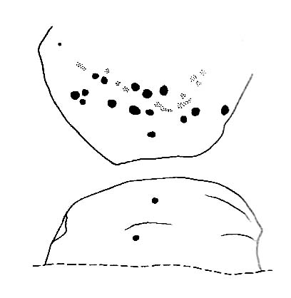
Rough Holden cup-marksBasic sketch of the stone
The main cluster of cups occurs on the northern-edge of the stone, where a couple of them seem linked by linear features. There are also what may be a cup or three on the vertical edge of the rock, below these cups – but this needs looking at again the better lighting. The cup-and-ring is very faint, but once noticed it become increasingly obvious that it’s there, and most of the ring can be traced with ease by running one’s finger along the groove. Mikki reckons the ring runs all the way round the cup (she’s probably right), where as I could only work it out running 75% of the way round. The line which runs off above the ring seems to link up with what looks like another obvious cup-marking on the photo. We’ll have to check it out properly next time we’re up there!
A bit troublesome this one – and the 8-figure grid-ref might be slightly astray (though only by a little). Get to the TV-mast below Rivock Edge and notice the small path going along the top of the adjacent field, over the fence, heading north-ish into the meadows — not the path into the forest. Walk on the meadow path, over the wall and notice a rise in the ground ahead of you. Go past this mound for about 75 yards and keep your eyes peeled!
Archaeology & History
Close-up of cup-markings
Named by virtue of the shape of the stone, the Keighley volunteer Michala Potts of Bracken Bank found this carving on an exploratory amble yesterday (Friday, June 12, 2009). Previously unrecorded, this carving consists merely of cup-markings — four distinct ones on the northeasterly edge of the rock, with two other ‘possibles’ thereon. The cups have been pretty well-eroded by the elements and there are few distinguishing features which will make this of any real interest, unless you’re a real rock-art freak!
Follow the same directions for reaching the Wondjina Stone. Once here, walk to the edge of the cliffs less than 10 yards away and the second largest of the rocks is the one you’re after. (the Rivock Nose [1] and [3] carvings are the rocks either side of this one)
Archaeology & History
Possible cup-markings at Rivock Edge
I’ve gotta admit, I was slightly surprised to find this carving logged in both Hedges (1986) and Boughey & Vickerman’s (2003) surveys. Although we find the distinct appearence of cup-markings near the edge of the cliff at the northwestern end of Rivock Edge, these seem a little too close to being natural to be comfortably acknowledged in archaeo-texts without notes the contrary. I took a photo of them when we were up visiting the other day, but didn’t expect them to be in the books. Not only do they include this probably natural example, they also add another two rocks found along the cliff edges (Hedges 12 & 13; B&V 45 & 47). In the event that these carvings are deemed authentic, then those along the edge of the great Kirk cliffs above Steeton must also be added to the same pot.
In the photo here you can work out perhaps nine cup-marks near the edge of the cliff, which is what the textbooks say. Make your own mind up when your next looking at the Wondjina Stone and others nearby.
References:
Boughey, Keith & Vickerman, E.A., Prehistoric Rock Art of the West Riding, WYAS 2003.
Feather, Stuart, ‘Mid-Wharfedale Cup-and-Ring Markings: Nos. 7 & 8, Rivock Edge,’ in Cartwright Hall Archaeology Group Bulletin, 6:8, 1961.
Hedges, John (ed.), The Carved Rocks on Rombald’s Moor, WYMCC: Wakefield 1986.
Follow the same directions to reach the nearby Wondjina Stone, but as you reach the trig-point at the top of Rivock Edge, note the smooth rounded boulder 50 yards ESE. That’s it!
Archaeology & History
Named after the sea of cotton grasses, or niplets (Eriophorum angustifolium), amidst which it lives for several weeks of the year, the cups-marks that make up this design can be terribly difficult to work out even in the best of lighting. We have here a lichen-encrusted stone with perhaps as many as 25 cup-marks scattering, mainly, the top and westerly sloping face. Although some of the cups are quite noticeable, the vegetative growth and simple erosion has made an accurate visual impression of the original carving very difficult — as the images plainly tell! If I ever manage to capture the stone resting in a good mood, I’ll replace the photos I’ve got here!
Niplet Stone, looking SEBeautiful fusion of faded cups, lichen & great age…
Although I remember coming here and seeing this and the nearby carvings when I was a teenager, then a few years later on with Edna Whelan and Graeme Chappell, it seems that the first literary note of this carving after my own initial exploration was in the Ilkley Archaeology Group’s survey (Hedges 1986), where they make note of a flint that was found beside the stone. Boughey and Vickerman (2003) later include the same stone in their work, but with no additional information.
References:
Bennett, Paul, “The Prehistoric Rock Art and Megalithic Remains of Rivock & District (parts 1 & 2),” in Earth, 3-4, 1986.
Boughey, Keith & Vickerman, E.A., Prehistoric Rock Art of the West Riding, WYAS 2003.
Hedges, John (ed.), The Carved Rocks on Rombald’s Moor, WYMCC: Wakefield 1986.
A wonderful site, though a bittova walk for city-minded folk. Head up the road from Riddlesden, Keighley, towards the southern edge of Rombalds Moor and keep going till you reach the road which surrounds the moor (called Silsden Road). At the T-junction in front of you is a path which takes you onto the fields and moor. Go over the stile and walk straight up the steepish field that follows the straight line of the forest, all the way to the top. Climb over the wall on your left when you reach the top of the tree-line, walk past the triangulation pillar for 100 yards or so till you hit the end of the walling before it drops back into the trees. The carving’s under your nose!
Archaeology & History
Rivock Edge’s ‘Wondjina’ carving
The name of this carving is based on a first impression I got of it when I came here as a young lad, still in my teens. The ‘Wondjina’ is a name given to primal aboriginal spirits whose images are etched and painted on rock surfaces in various parts of Australia (usually rock overhangs or in caves). Don’t ask me why, but that was the impression I first got of this stone — and it’s something that stays with me. Some archaeo’s won’t like the association such mythic ancestral beings may have upon people’s notions of cup-and-ring art, but they tend to be the ones who have little educational background regarding the animistic nature of rocks in traditional and peasant societies: ingredients that are integral to these ancient carvings, as research worldwide clearly shows.
The carving was first described by our old Yorkshire historian Arthur Raistrick (1936) in an early essay on Yorkshire rock carvings; and then again in a later article by Stuart Feather. (1961) The primary design is of a large single cup-and-ring at one end of the rock, with a series of seemingly unbroken lines reaching up (or perhaps moving away) from the cup-and-ring. A long central line runs through the middle of the Wondjina ‘being’, which initially seems to have been a series of cups linked by this line; though these cups (at least four of them) have eroded over time and are difficult to see without good sunlight. What seem to be several other very eroded cup-marks are also found on two of the other long lines. These can be made out in the photograph here.
Close-up of lines & cup-marks
Another carving is on the stone right next to this one (2ft away) and there are several other cup-marked stones to be found along the same ridge (carving numbers 058, 059, 060, etc). And for those of you into landscape archaeology, take the position of this carving into consideration. The view from here is quite superb and on clear days a number of prominent hills and important mythological landscape features stand out. To those of you who think such things unimportant or of little relevance in the mythography of our ancestors — you’ve a lot to learn! Otherwise, a visit to this carving and its associates is well worth a trek!
References:
Bennett, Paul, ‘The Prehistoric Rock Art and Megalithic Remains of Rivock & District (2 parts),’ in Earth, 3-4, 1986.
Boughey, Keith & Vickerman, E.A., Prehistoric Rock Art of the West Riding, WYAS 2003.
Feather, Stuart, ‘Mid-Wharfedale Cup-and-Ring Markings: Nos. 7 & 8, Rivock Edge,’ in Cartwright Hall Archaeology Group Bulletin, 6:8, 1961.
Hedges, John (ed.), The Carved Rocks on Rombald’s Moor, WYMCC: Wakefield 1986.
Raistrick, Arthur, “‘Cup-and-Ring’ Marked Rocks of West Yorkshire,’ in Yorkshire Archaeology Journal, 32, 1936.
From East Riddlesden, go up the road (over the swing-bridge) that takes you onto the moor-edge (ask a local if you have trouble). Go all the way up till you hit the road which encircles the moor (it’s called the Silsden Road where you hit it). Turn left for several hundred yards till you see the microwave tower just on the hillock to your right on Pinfold Hill (not the larger TV towers just below the forest). Walk up there, then follow the edge of the walling till you hit the old Pinus sylvestris trees of Robin Hood’s Wood where 2 walls meet. Go over the gate and walk to your right for about 200 yards, following the line of the walling. You’re there!
Archaeology & History
Cluster of cups on W edge
A newly-discovered cup-marked stone, located for the first time on Tuesday, June 9, 2009, by Michala Potts, who was out on an amble with some long-haired halfwit whizzing about getting excited about stupid cup-markings on stones, dragging her back and forth and leaving her in the middle of a bog! On one occasion when this ‘ere fruitbat wandered off (again!), leaving her alone in the middle of the hills, she decided to check out some rocks a bit further up the slope where she’d been left alone. And there, along the edge of some walling, right on the edge of the much-denuded Robin Hood’s Wood, a short distance west of Rivock, a curious stone popped out and caught her attention!
Was this a cup-marking she saw before her!? It certainly was! But she didn’t call out to this halfwit who’d left her to her own devices. She let him just wander off to his sad heart’s content, whilst she got into the nitty-gritty of checking the stone out, uncovering the essentials of the carving while he bimbled off like a freak! And what a nice carving it was she found…
Baldwin Stone – looking westFirst sketch of the stone
Although no accurate measurements were made of the stone (it was bigger than 10-inch!), at least 17 cup-markings were counted here: one singular and very well-preserved cup, alone on its southern edge, right by the walling. But the main feature of the design is a cluster of cup-marks (at least 11) on the western side of the rock — one part of this cluster having the appearance of the figure 5 on a dice! Several other well-defined cups occur on the central and more northern end of the rock.
Eventually, her sad stone-wandering fella returned, forlorn, having found no new carvings of his own (poor soul!). And so she took his poor little hand, and took him to see the little prehistoric treasure she’s uncovered — and her sad little man got all smiley and … well, you know what they’re like!
Additionally however, for the archaeo’s amongst you: if you come wandering up here to check this carving out, you’ll notice the remains of many large upright stones in a lot of the old stone walls round here. Many of these are the remains of Iron Age walling.
One of two ways to get here really. The easiest is from Sutton-in-Craven: go through the village and up the steep hill (don’t take the right turn as you start up the hill). Go all the way up until the hill starts to level out and on the left-side of the road you’ll notice a boundary stone stood upright (this is the Sutton Stoop). Stop here. Of the 2 gates, climb over the top-most one and walk down the path into the adjacent field, heading over to the gap a couple of hundred yards away where the gate to another field is. That’s it!
Archaeology & History
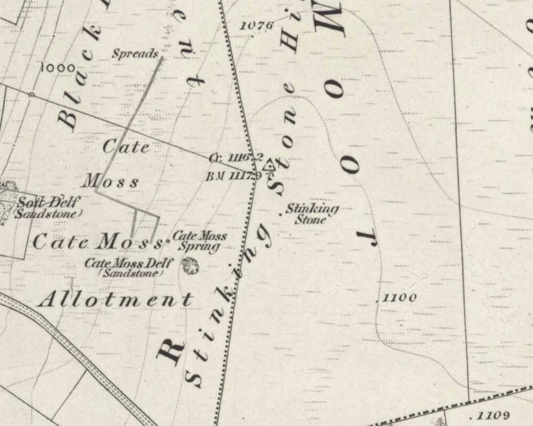
Stinking Stone, Steeton
Now here’s a weird one. With a name like this you’d expect there to be plenty of info or historical comments. But despite all the books and journals in my huge library, aswell as visiting town libraries and exploring the resources on-line, there’s nowt written about this ‘ere spot. Not a jot! Even the usually satisfactory place-name fellas have a thing-or-two to say about sites with names such as this—but even their old tomes are closed-lipped. Hmmmmm…..
I visited the place several times to try ascertain what this site was, thinking — perhaps — that it was an old boundary stone whose name had been convoluted from some older, more obvious title.* The nearby Sutton Stoop boundary stone, right by the roadside, seemed a good indicator to such an assumption, as it was a recognised boundary marker with written history and a meeting point along the local perambulation. But the curiously-named Stinking Stone was neither on the same line, nor ever had been according to old records, and couldn’t be located either. There had been obvious quarrying and other industrial destruction along the hilltop where the old stone was marked and it seemed logical to assume that it had been destroyed in bygone years by that usual breed of capitalist industrial halfwits. Until a psilocybin venture one afternoon, last season…
Twas a lovely sunny day, though windy on the tops as usual. I was out with a couple of neophytes showing them Psilocybes and various other species, chewing them here and there and talking the way of healthy usage. We passed by an old well, long forgotten, before heading onto Stinking Stone Hill. Bimbling somewhat, and ruminating about the moss of colour, we decided to sit by the walling in-field and dream for a short while. As we hit the old gate the Stinking Stone came up right before us. Literally!
There in the old walling, blunt as you like, stood this four-and-a-half-foot tall standing stone, smoothed on one side by a short aeon of weathering, upright and proud as if it had been stood there for centuries, awaiting attention! I exclaimed a few triumphant expletives; rubbed myself here and there over the old thing, then sat for a while behind the wind with the old upright, solidly embedded in old earth — then awaited the dream…
Twas a good day…
And then I returned home and later sought what I could on a possible etymology. Around the hilltop a hundred yards away were small depressions and the faded remains of industrial workings, like I said; and with this in mind the awesome Mr Wright (1905) told us about the existence of ‘Stinking coals’, “an inferior kind of coal” no less. Referring us to a work from 1818, we’re told,
“The Stinking-coal is noted for containing a great proportion of sulphuret of iron, thick seams or layers of these pyrites running in it. In consequence of this it cannot be used for smelting purposes.”
Another account from 1868 telling us that:
“On opening the body, it contains a strong sulphureous smell, characteristic of the disease; hence it is called the stinking ill; and the stomach and bowels are prodigiously distended with air, having the same intolerable foetor.”
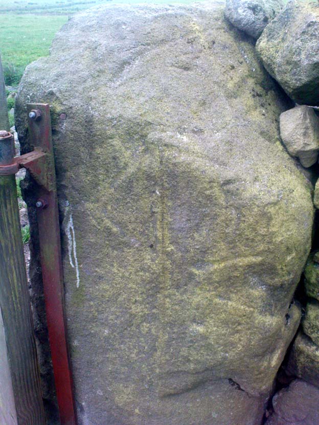
Worn metal scratches, made when dragged here?
This old worn gatepost however, perhaps has a history that only goes back a few centuries. It has been cleaved in half, as you’ll see if you visit it; but its western face is old and worn and it’s been embedded in the ground for a long time. On its northern face are the curious etchings of carvings, which are more akin to wounds from some past offence (perhaps when it was split in half), cleaved by metal toolings and dragged by farmers to be fixed in into present spot. It’s history may not be truly ancient. Twouldst be good to know for sure though…
References:
Wright, Joseph, The English Dialect Dictionary – volume 5, Henry Frowde: Oxford 1905.
* ‘Stinking’, stone-king or King Stone? Unlikely though…
Dead easy this one! Go along North Street in Keighley, towards the main church in the middle of town (a St. Andrew’s church, previously St. Pete), by the once-infamous Lord Rodney pub, and the old stone edifice stands outside by the Green. The much better Red Pig public house is across the road from here.
Archaeology & History
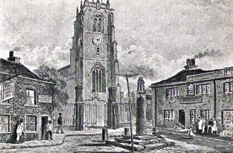
Keighley’s Town Cross, 1847 – on a painting by Edwin Riby
For a relatively trivial archaeological site, it’s got a bittova history. Not that this is an old site either! We’re not sure just when this cross was made, but it’s certainly no more than 300 years old. Before standing in its present position outside St. Andrew’s Church, sometime before 1840 it was said to have been a few hundred yards away above the present roundabout on Oakworth Road; and one record tells that it originally came from nearby Utley, a mile to the north. Due to lack of decent records, we’re not sure about its early status as a market cross, nor when it was first erected. Indeed, even the steps on which the cross presently stands are clearly more recent than the ones illustrated on Edwin Riby’s 1847 portrait, reproduced here.
Keighley Cross, on a grey wet day!
It would be good to get a complete history of this archaeological relic but it’s difficult with artifacts such as these; and although gaining access to the church now takes less time and effort than it used to (the vicar here used to be quite unhelpful, but has recently changed his ways – which is good!), it’s only open at certain times of the week.* Friday afternoons seem OK to have a look round. Please – if folk begin having trouble gaining access to the Church once more, let us know on here so we can make complaints about it. The Church is paid for by local tax-payer’s cash, and so needs to be open to all of us. Let’s hope this humble ingredient can be maintained for the good of all in this otherwise regressive social community (Keighley, that is…).
There’s also some very curious folklore to be added here in relation to the market and its cross, but its tale is gonna have to wait…
References:
Gray, Johnnie, Through Airedale, from Goole to Malham, Elliott Stock: London 1891.
Keighley, William, Keighley, Past and Present, R. Aked: Keighley 1858.
* There isn’t even a notice giving information, email or phone numbers, telling you who you can contact if you want to know anything about the history of the church, or visit it — which is quite dreadful considering how much money they get paid by tax-payers for their supposed socio-spiritual duties.
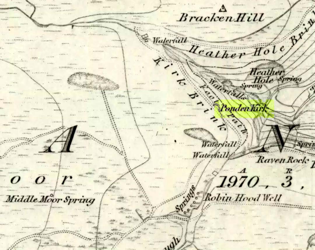
Go west through Stanbury village towards Lancashire for a mile till you reach the end of Ponden Reservoir. Where the water ends, follow the small track up to, and past, Whitestone Farm, till you reach the stream. Follow the valley up…
Archaeology & History
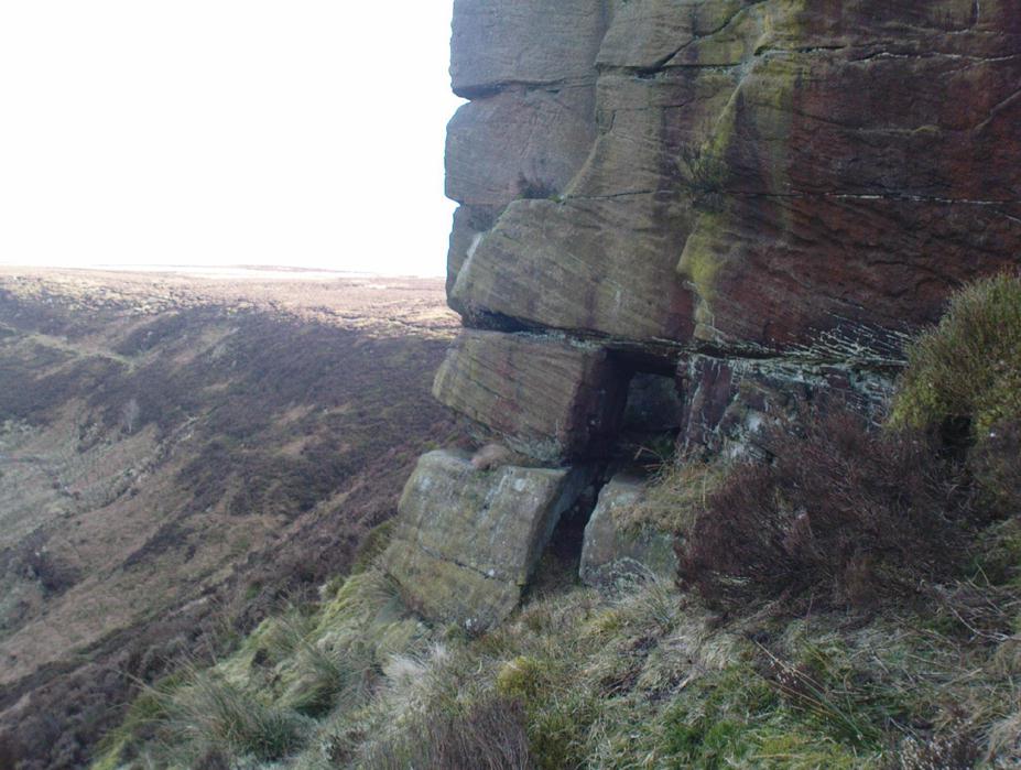
As the great Yorkshire historian J. Horsfall Turner (1879) told, “Ponden Kirk consists of a ledge of high rocks, dry in summer, but forming a stupendous cataract after heavy rain. It was here that Mrs Nicholls (Currer Bell) caught a severe cold shortly before her death.” The site is a fine one – not to be attempted from the base by unfit doods, unless you’re really serious about your climbing! But to those of us who like clambering up rocks and wholesome scenery, walk to the site via the stream (Ponden Clough Beck) and get to the cleft in the rock face. Tis a truly fine place!
Ponden Kirk from below
In 1913, one writer posited the notion that the opening in the rocks through which local folk crawl (see Folklore, below) “is seemingly artificial” – which aint quite true, sadly.
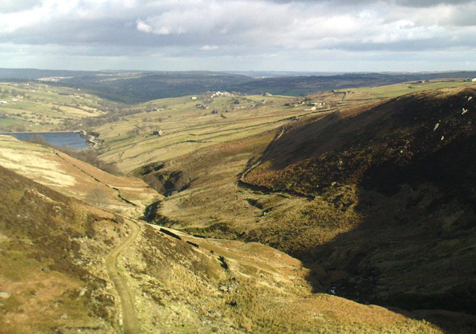
Once on the tops above the Kirk, you’ve one helluva decent view, be it raining or sunny. On the far northeastern horizon arises the great omphalos of Almscliffe Crags; and next to that is the elongated top of Baildon Hill; and a little further northeast is Otley Chevin. It would be good to visit here on a few of the old heathen days and watch the sunrise, just to see if there are any intriguing solar observations to be made! (take a tent though – or p’raps, if you’re like us, don’t bother, but you’ll be bloody cold for the night!) The only potential sunrises of heathen significance appear to be midsummer and Beltane….
Ponden Kirk on 1851 map
For me at least, one of the things which gives this site an intriguing form of sanctity is the fact that the Kirk itself forms the head at the end of the valley. It is a very fine ritual site and would obviously have had much more to be said of it than just the heathen marriage rites which are left today. The forces of wind and rain scream from its height, and in the valley beneath the chime of the gentlest echoes resonate, giving an altogether different ‘spirit’ amidst the same land. Those old cherubs of ‘male’ and ‘female’ spirit commune potently here – no doubt being the ingredients which gave form to the marriage customs… Those of you into feng-shui (the real stuff, not the modern bollox) and genius loci should spend time with the water and rocks here and you’ll see what I mean. Archaeologists amongst you, if you dare, should amble aimlessly here for sometime…for many hours, a few times, and give yourselves a notion of the ‘ritual landscapes’ you like to write about from the safety of your textbooks, to get a bittova better notion of what ‘experiencing the land’ is actually about.
Ponden Kirk’s opening
This rocky outcrop was also said to be the place that Emily Bronte used in her Wuthering Heights novel as the place called Penistone Crags. A couple of other local writers have also added this legendary place in their tales aswell.
Folklore
Alleged by Elizabeth Southwart (1923) “to be of druidical origin,” the first literary note of this great rock outcrop appears to come from the reverend James Whalley (1869) of Todmorden, who in his romantic amblings over the moorlands here, told that if any gentleman wants to get married,
“he must by all means pay a visit to Ponden Kirk… Here ‘they marry single ones!’ Any lady or gentleman who can successfully ‘go through one part of the rock’ (which is quite possible) is declared to all intents and purposes duly married according to the forms and ceremonies of Ponden Kirk.”
The view from the top
His wording here seems to imply that the event of passing through the rocky opening, is in itself a confirmation of the ceremony of marriage, not needing the blessing of some strange christian rites. If so, this tradition would be a very ancient one indeed, making the stone the witness to the marriage event. This would be a rite witnessed by the stones themselves: a universal heathen attribute found in most of the ancient traditional cultures. But this curious unwritten history was to be echoed a decade later by that great Yorkshire historian, J. Horsfall Turner (1879), who told us that,
“at Ponden Kirk, as at Ripon Minster, a curious wedding ceremony is frequently observed. It consists in dragging one’s-self through a crevice in the rock, the successful performance of which betokens a speedy nuptial… The place is now frequently called ‘Wuthering Heights. Apart from the association of such names as Crimlesworth and Oakden (see the Alcomden Stones), fancy easily ascribes a druidical settlement at the Kirk.”
A not unreasonable assumption – though nothing of this nature, of yet, has been found.
That other great Yorkshire writer, Harry Speight — aka Johnnie Gray (1891) — echoed the same folklore telling how,
“The natives of these parts have a saying, ‘Let’s go to Ponden Kirk where they wed odd ‘uns,’ which has its origin in an old custom of passing through an enormous boulder… The belief is that if you pass through it, you will never die single. No one knows how the rock acquired its name, but the Saxon kirk suggests a temple of worship, possibly extending back to the druidical times.”
Ponden Kirk – by T. MacKenzie, c.1923
A few years later, Mr Whiteley Turner came here and he too affirmed the old wedding rites, also telling that “according to tradition, maidens (some say bachelors too) who successfully creep through the aperture will be married within the year.” This bit of info also shows that the rocks also had oracular properties – a function known at countless other sites.
The proximity of Robin’s Hood Well, just a couple of hundred yards away, beckons for association with the Ponden Kirk – which it obviously had… But that’s a tale to be told elsewhere…