Follow the same directions to reach the nearby Wondjina Stone, but as you reach the trig-point at the top of Rivock Edge, note the smooth rounded boulder 50 yards ESE. That’s it!
Archaeology & History
Named after the sea of cotton grasses, or niplets (Eriophorum angustifolium), amidst which it lives for several weeks of the year, the cups-marks that make up this design can be terribly difficult to work out even in the best of lighting. We have here a lichen-encrusted stone with perhaps as many as 25 cup-marks scattering, mainly, the top and westerly sloping face. Although some of the cups are quite noticeable, the vegetative growth and simple erosion has made an accurate visual impression of the original carving very difficult — as the images plainly tell! If I ever manage to capture the stone resting in a good mood, I’ll replace the photos I’ve got here!
Niplet Stone, looking SEBeautiful fusion of faded cups, lichen & great age…
Although I remember coming here and seeing this and the nearby carvings when I was a teenager, then a few years later on with Edna Whelan and Graeme Chappell, it seems that the first literary note of this carving after my own initial exploration was in the Ilkley Archaeology Group’s survey (Hedges 1986), where they make note of a flint that was found beside the stone. Boughey and Vickerman (2003) later include the same stone in their work, but with no additional information.
References:
Bennett, Paul, “The Prehistoric Rock Art and Megalithic Remains of Rivock & District (parts 1 & 2),” in Earth, 3-4, 1986.
Boughey, Keith & Vickerman, E.A., Prehistoric Rock Art of the West Riding, WYAS 2003.
Hedges, John (ed.), The Carved Rocks on Rombald’s Moor, WYMCC: Wakefield 1986.
A wonderful site, though a bittova walk for city-minded folk. Head up the road from Riddlesden, Keighley, towards the southern edge of Rombalds Moor and keep going till you reach the road which surrounds the moor (called Silsden Road). At the T-junction in front of you is a path which takes you onto the fields and moor. Go over the stile and walk straight up the steepish field that follows the straight line of the forest, all the way to the top. Climb over the wall on your left when you reach the top of the tree-line, walk past the triangulation pillar for 100 yards or so till you hit the end of the walling before it drops back into the trees. The carving’s under your nose!
Archaeology & History
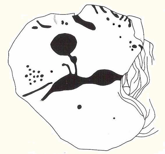
Rivock Edge’s ‘Wondjina’ carving
The name of this carving is based on a first impression I got of it when I came here as a young lad, still in my teens. The ‘Wondjina’ is a name given to primal aboriginal spirits whose images are etched and painted on rock surfaces in various parts of Australia (usually rock overhangs or in caves). Don’t ask me why, but that was the impression I first got of this stone — and it’s something that stays with me. Some archaeo’s won’t like the association such mythic ancestral beings may have upon people’s notions of cup-and-ring art, but they tend to be the ones who have little educational background regarding the animistic nature of rocks in traditional and peasant societies: ingredients that are integral to these ancient carvings, as research worldwide clearly shows.
The carving was first described by our old Yorkshire historian Arthur Raistrick (1936) in an early essay on Yorkshire rock carvings; and then again in a later article by Stuart Feather. (1961) The primary design is of a large single cup-and-ring at one end of the rock, with a series of seemingly unbroken lines reaching up (or perhaps moving away) from the cup-and-ring. A long central line runs through the middle of the Wondjina ‘being’, which initially seems to have been a series of cups linked by this line; though these cups (at least four of them) have eroded over time and are difficult to see without good sunlight. What seem to be several other very eroded cup-marks are also found on two of the other long lines. These can be made out in the photograph here.
Close-up of lines & cup-marks
Another carving is on the stone right next to this one (2ft away) and there are several other cup-marked stones to be found along the same ridge (carving numbers 058, 059, 060, etc). And for those of you into landscape archaeology, take the position of this carving into consideration. The view from here is quite superb and on clear days a number of prominent hills and important mythological landscape features stand out. To those of you who think such things unimportant or of little relevance in the mythography of our ancestors — you’ve a lot to learn! Otherwise, a visit to this carving and its associates is well worth a trek!
References:
Bennett, Paul, ‘The Prehistoric Rock Art and Megalithic Remains of Rivock & District (2 parts),’ in Earth, 3-4, 1986.
Boughey, Keith & Vickerman, E.A., Prehistoric Rock Art of the West Riding, WYAS 2003.
Feather, Stuart, ‘Mid-Wharfedale Cup-and-Ring Markings: Nos. 7 & 8, Rivock Edge,’ in Cartwright Hall Archaeology Group Bulletin, 6:8, 1961.
Hedges, John (ed.), The Carved Rocks on Rombald’s Moor, WYMCC: Wakefield 1986.
Raistrick, Arthur, “‘Cup-and-Ring’ Marked Rocks of West Yorkshire,’ in Yorkshire Archaeology Journal, 32, 1936.
From East Riddlesden, go up the road (over the swing-bridge) that takes you onto the moor-edge (ask a local if you have trouble). Go all the way up till you hit the road which encircles the moor (it’s called the Silsden Road where you hit it). Turn left for several hundred yards till you see the microwave tower just on the hillock to your right on Pinfold Hill (not the larger TV towers just below the forest). Walk up there, then follow the edge of the walling till you hit the old Pinus sylvestris trees of Robin Hood’s Wood where 2 walls meet. Go over the gate and walk to your right for about 200 yards, following the line of the walling. You’re there!
Archaeology & History
Cluster of cups on W edge
A newly-discovered cup-marked stone, located for the first time on Tuesday, June 9, 2009, by Michala Potts, who was out on an amble with some long-haired halfwit whizzing about getting excited about stupid cup-markings on stones, dragging her back and forth and leaving her in the middle of a bog! On one occasion when this ‘ere fruitbat wandered off (again!), leaving her alone in the middle of the hills, she decided to check out some rocks a bit further up the slope where she’d been left alone. And there, along the edge of some walling, right on the edge of the much-denuded Robin Hood’s Wood, a short distance west of Rivock, a curious stone popped out and caught her attention!
Was this a cup-marking she saw before her!? It certainly was! But she didn’t call out to this halfwit who’d left her to her own devices. She let him just wander off to his sad heart’s content, whilst she got into the nitty-gritty of checking the stone out, uncovering the essentials of the carving while he bimbled off like a freak! And what a nice carving it was she found…
Baldwin Stone – looking westFirst sketch of the stone
Although no accurate measurements were made of the stone (it was bigger than 10-inch!), at least 17 cup-markings were counted here: one singular and very well-preserved cup, alone on its southern edge, right by the walling. But the main feature of the design is a cluster of cup-marks (at least 11) on the western side of the rock — one part of this cluster having the appearance of the figure 5 on a dice! Several other well-defined cups occur on the central and more northern end of the rock.
Eventually, her sad stone-wandering fella returned, forlorn, having found no new carvings of his own (poor soul!). And so she took his poor little hand, and took him to see the little prehistoric treasure she’s uncovered — and her sad little man got all smiley and … well, you know what they’re like!
Additionally however, for the archaeo’s amongst you: if you come wandering up here to check this carving out, you’ll notice the remains of many large upright stones in a lot of the old stone walls round here. Many of these are the remains of Iron Age walling.
Follow the same directions for getting to the Idol Stone, then walk just 30 yards further up the path and it’s the big rock on your left-hand side. Y’ can’t miss it!
Archaeology & History
Main section of cup-marks
This nice big boulder can be quite a temperamental chap, depending on how the light plays with the rock surface. I’ve got some photos of this old stone where you can see next to nowt on it; where as others show clearly aspects of the design that aren’t on the archaeo-images. But such is the nature of cup-and-rings I s’ppose!
Unlike its rather linear companion a few yards away, this great boulder has the more typical scattering of faded cups, lines and at least one cup-and-ring, etched with seemingly little purpose or structural design. But as we know, the very notion of structural design in forms consistent to modern mind-sets were anathema to the neolithic people who were etching these patterns on rocks. Indeed, even the notions of these images as ‘art’ as defined in modern times, has no relationship to the intrinsic reality of either cup-and-rings or reality per se, as experienced by our ancestors. And I think we find an explicit affirmation of this in the Cluster Stone here.
Close-up of cup-and-ring
Natural cuts in the rock have been heightened, for whatever reason, so that today the division between Nature’s marks and the mark of humans have become ambiguous as time has worn the features. The clustering of cup-marks on certain parts of the rock was surely indicative of (what we would term) separate events/forms, whose mythic relationship were, however, intrinscially related. This may be representative of a landscape map, or a series of events – but each would relate to one and other. But, of course, we truly don’t know, so think I’d best shut up!
Cluster Stone design (after Hedges 1986)
The carving itself, as we can see today, has perhaps as many as 40 cup-marks on it (Boughey & Vickerman safely vouch for 26), with five or six lines running across the surface, some of which have been modified by ancient peoples. The cup-and-ring on the stone is quite distinct. Neolithic or Bronze Age walling runs just a few yards away from here, but the precise line it takes has not been accurately assessed.
References:
Boughey, Keith & Vickerman, E.A., Prehistoric Rock Art of the West Riding, West Yorkshire Archaeology Service 2003.
Hedges, John (ed.), The Carved Rocks on Rombald’s Moor, WYMCC: Wakefield 1986.
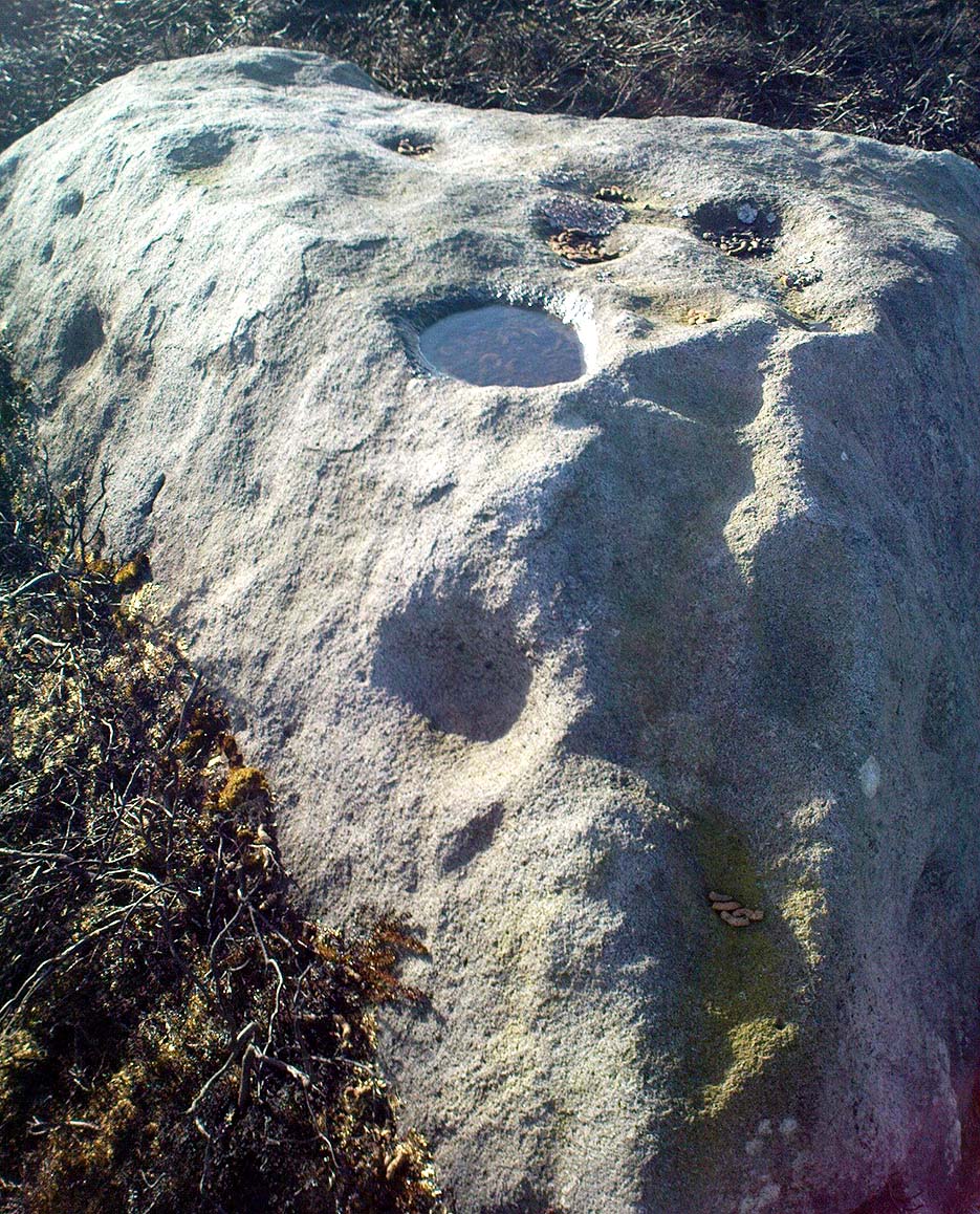
Follow the same directions to reach the Pancake Stone. Then walk eastwards along the footpath on the moorland edge. After about 400 yards, keep your eye out to your right on the moorland proper where you’ll see this large boulder, seemingly isolated, of similar shape to the Haystack Rock, but a bit smaller. That’s it! If you end up near the stream (Rushy Beck) you’ve gone way past it.
Archaeology & History
Four of the cups on this lichen-rich surfaceLittle Haystack (after Hedges 1986)
Found in the middle of the Green Crag Slack Plain, this large Haystack-Rock-shaped boulder stands out. It sits amidst a cairn-field with other neolithic remains nearby. The carving itself aint that impressive, and some parts of it seem almost dubious. But both Hedges, Boughey and Vickerman include it in their surveys, describing the cup-marks and curious lines on its northeastern surface. It’s nowt special to be honest. You’d expect a bit more from the size of this old stone; but as those folk who know their rock art well will tell you, size aint everything when it comes the splattering of cups on a rock’s surface. We have four distinct cups pretty close to each other (as the photo shows), with another possible cup-and-ring and accompanying lines nearby.
The stone’s worth looking at though. It stands out amidst the mass of single- and double-tombs scattered across the moorland plain — sitting amidst a veritable necropolis no less.
References:
Boughey, Keith & Vickerman, E.A., Prehistoric Rock Art of the West Riding, West Yorkshire Archaeology Service 2003.
Hedges, John (ed.), The Carved Rocks on Rombald’s Moor, WYMCC: Wakefield 1986.
From the large village of Summerbridge, go west along the B6541 towards Dacre Banks, where you’ll see the signpost for the Nidderdale Way footpath. Follow this past the disused quarry and onto the meadows. When you hit the Monk Ing road, bear right (north) and keep going till you’re 100 yards from Eastwoods Farm. Go right, down into the fields for 50 yards or so. Look around!
Archaeology & History
A previously unlisted single cup-marked stone which is likely to become overgrown by the grasses pretty soon. Several other carvings are in close attendance in this field. It’s not far from the cup-marked Eastwoods Cross Base (aka CR 637) in the same field, but a little further down. In all probability there are other carvings yet to be found in this area. The rock art student Keith Boughey (2007) mentioned it briefly in an article on the other carvings nearby, saying simply:
“A small area of rock (very possibly bedrock) measuring 40cm x 14cm at its greatest extent pokes up through the turf, showing one worn but clear cup-mark on its western edge (Fig 3). On its own, this marking would not be significant were it not for the fact that four other carved rocks are already recorded from this particular locality.”
The Young Idol Stone (bottom) & parental Idol Stone above
Take the directions to reach the Haystack Rock, then head onto the moor following the south-east footpath for a few hundred yards, towards where the moor slopes uphill. 20-30 yards before the uphill slope, a yard to the right of the path, a couple of yards below the well-known Idol Stone carving – you’ll find it!
Archaeology & History
Described simply as a “small, rounded, smooth grit rock,” this long-tooth-shaped stone has just two cup-markings on its upper face: one on the more southern tip, and the second smaller cup several inches below it – as shown on the photo. The adjacent carving seen at the top of the photo is the parent guardian, Idol Stone! If you visit this, or any adjacent carvings here, please remember that all along this moorland plain are numerous unexcavated prehistoric tombs. You’re effectively stood at the edge of, or within, a huge prehistoric cemetery.
References:
Boughey, Keith & Vickerman, E.A., Prehistoric Rock Art of the West Riding, WYAS 2003.
Hedges, John, The Carved Rocks on Rombalds Moor, WYMCC: Wakefield 1986.
Head for the binary-like Idol Stone carving and keep walking on the footpath, up the hill. Once on top of the ridge, walk along it to your right (west) for about 300 yards, then walk south (left) into the flat heathland plain. Look around!
Archaeology & History
I’m probably not reading it right – but it seems this large stone with several distinct cup-marks on its vertical south-face, isn’t in the surveys of either Hedges (1986) or Boughey & Vickerman (2003). If someone can correct me on this one – please do!
Green Crag Top Stone, looking north
This is quite a large boulder, as the photos here show. At least two average-sized cup-markings have been etched onto the south face, and two larger ones accompany them on the same edge. There’s another larger cup-mark on the northeast side of the stone, and a possible companion, which may or may not be artificial. Then on top of the stone we have several large cups and a ‘bowl’ — though some of these upper markings may be natural, or just well-eroded cup-marks. It’s hard to tell for sure!
Now I’m gonna have another look in the Hedges, Boughey & Vickerman surveys. They surely can’t have missed this!
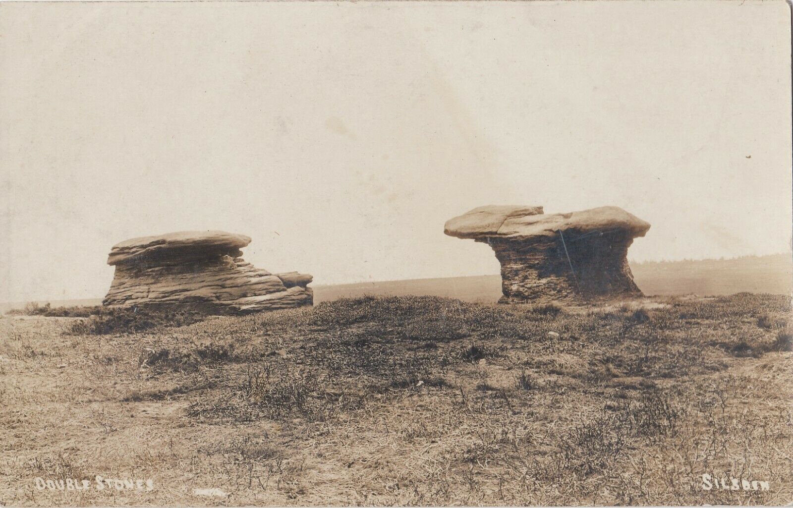
Various ways to get here, but the 2 most common are: (1) from Brunthwaite village, above Silsden, following the road uphill for a mile, then turning right (west) onto the moorland dirt-track to Doubler Stones Farm. Just before here there’s a footpath uphill (north) for 200 yards to the stones. (2) follow the Millenium Way footpath south up Addingham Moorside, onto Addingham High Moor. Keep going on the same path another 500 yards and they’ll appear ahead of you.
Archaeology & History
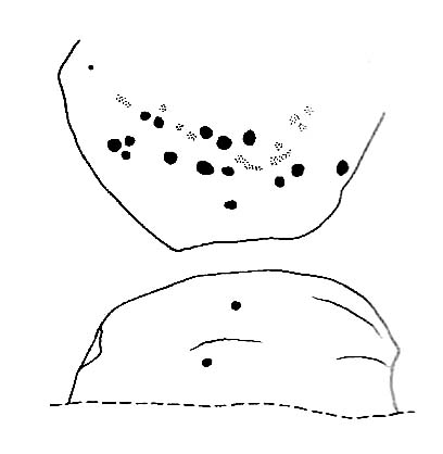
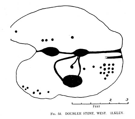
First described as the ‘Doublestones’ in the local Addingham parish records of 1786, these great mushroom-shaped rocks were later brought to the attention of archaeologists by J. Romilly Allen in 1879 and they greatly intrigued numerous Victorian antiquarians, who puzzled as much about their exotic forms as the cup-marks on their tops! Allen wrote of them:
Cowling’s old drawingHedges (1986) sketch of the design
“These rocks are by far the most remarkable freaks of Nature to be seen in the district. They occupy a prominent position, perched on the extremity of a rocky knoll which juts out into the valley; and as seen from below, with their weird forms standing out clear and sharp against the background of blue sky, they present so extraordinary an appearance that they would at once attract the attention of even the most unobservant. In general outline they resemble gigantic toadstools; and I presume that they are called Doubler Stones from the fact of their shapes being almost identical. They may be appropriately described as Nature’s Twins. The upper surface of the cap of one of these stones has three large basin-shaped cavities in it. Two of these lie along the central axis of the stone, and measure respectively 1ft 3in by 2ft 9in deep, and 1ft 9in by 1ft 3in by 9in deep. They are united by a deep groove, a continuation of which runs out over the edge of the stone at each end. There is another basin lying to the west side of the two central ones, with one of which it is connected by grooves. It measures 2ft by 1ft 9in and is 9in deep. There is no direct evidence that these basins are artificial; but it is quite possible that they may have been so originally, and have been enlarged by natural agencies. But in addition to the basins, are twenty-six cup-markings of distinctly artificial origin. They vary in diameter from 2 to 4 in. One group of cups appears to be arranged in parallel rows.”
Doubler Stones, c.1890
Although the writer thought there were no artificial cup-markings on the other Doubler Stone (the one on the left in the photo), John Hedges (1986) and Boughey & Vickerman (2003) cite there to be at least two cup-markings on this rock. Other writers have given different numbers for the respective cup-marks thought to be on these rocks down the years.
If you’re into prehistoric rock-art, check this place out. If you’re a geologist and aint been here, you’ll be even more impressed!
Folklore
Approaching the Doublers (photo – James Elkington)
In Nicholas Size’s Haunted Moor (1934) he described the Doubler Stones as being the abode of ghosts and a place of sacrificial rites in ancient days. While in Guy Ragland Phillips’ Brigantia, we find that the word ‘doubler’ itself “is a large shallow dish, bowl or plate” – which we find on top of the greater one of these two well-worn-weirdoes. As well as being haunted, there is some other little-known, though not unexpected folklore here, which told these old stones to be the meeting place of witches in previous centuries.
In addition to this, we are told that the witches of Fewston valley to the west used to meet up with the more famous Pendle witches at these stones. One historian proclaimed that this notion was spurious, as it would be too far for the Pendle witches to walk – which says more about the historian in question than the people of previous centuries. The distance from Pendle to the Doublers can be traversed in a day and is an ideal meeting spot, away from the prying eyes of a wrathful Church, that sought war against the animistic practices of our ancestors.
References:
Allen, J. Romilly, ‘The Prehistoric Rock Sculptures of Ilkley,’ in Journal of the British Archaeological Association, volume 35, 1879.
Allen, J. Romilly, ‘Notice of Sculptured Rocks near Ilkley,’ ibid, volume 38, 1882.
Bennett, Paul, The Old Stones of Elmet, Capall Bann: Chieveley 2001.
Boughey & Vickerman, Prehistoric Rock Art of the West Riding, West Yorkshire Archaeology Service 2003.
Cowling, Eric T., Rombald’s Way, William Walker: Otley 1946.
Hedges, John, The Carved Rocks on Rombalds Moor, WYMCC: Wakefield 1986.
Jennings, Hargrave, Archaic Rock Inscriptions, A. Reader: London 1891.
Phillips, Guy Ragland, Brigantia: A Mysteriography, RKP: London 1976.
Size, Nicholas, The Haunted Moor, William Walker: Otley 1934.
To get here, follow the same directions as if you’re going to the Morphing Stone. This carving is in the same field, but about 100 yards SSW of there, just to the south-side of the Nidderdale Way footpath. There’s plenty of rocks about, but with a bit of patience or a natural rock-art dowser’s nose, you’ll find the carving easily enough!
This is another relatively recent find — though I wonder whether the nearby ‘Fertility Stone’ (about 500 yards north, in some walling) should switch names with this carving, as this one gives the distinct impression of sperm fertilizing the egg! Don’t you agree!? The name of the Tadpole Stone was given to it by Michala Potts — and the photograph and design are used, courtesy of Richard Stroud. In the next field from here, towards Eastwoods Farm, we find the Eastwoods Cross base and cup-markings and adjacent cup-marked stone. Not far away are other carvings, aswell as a number of other Bronze- and Iron-Age sites.
This design was described in Keith Boughey’s (2007) article on the rock art around Eastwoods Farm, telling how it
“was discovered by Kevin Cale and reported to the N.Y.C.C. SMR back in 2001… A low profile moss-covered earthfast rock a little over 1m in diameter in any one direction immediately S of the Nidderdale Way about 100m east of the end of Monk Ing Road and S of Eastwoods Farm at SE 18601 61643 and 172m O.D. Its domed surface carries a somewhat unusual design interestingly reminiscent of the design carved at the previous site which lies in the same field and landscape 160m to the north-west… An oval or egg-shaped groove enclosed up to six cups; a groove or channel, often referred to as a ‘comet tail’ in rock art motif vocabulary, runs from the central group of the six out beyond the enclosing groove, bends sharply and continues down over the sloping face of the rock. A wide groove at the base of the rock running into the present turf line may be a further element of the carving.”
References:
Boughey, K., “Prehistoric Rock Art: Four New Discoveries in Nidderdale,” in Prehistoric Research Section Bulletin, no.44, Yorkshire Archaeological Society 2007.