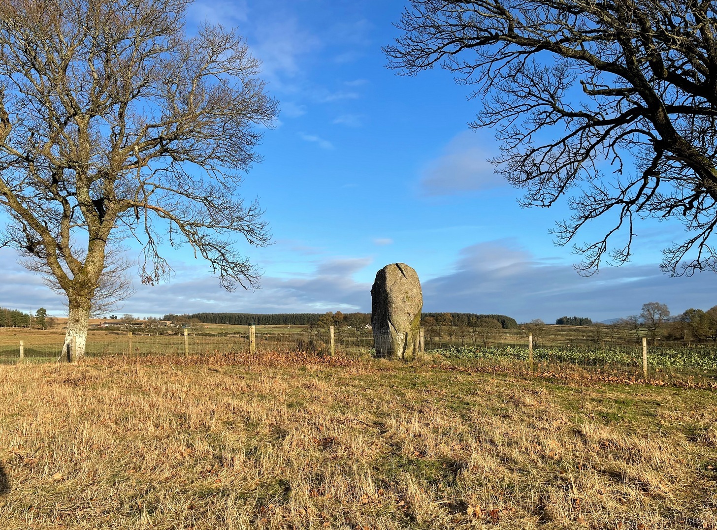
Take the tiny long winding B8063 road that runs west off the A9 at Luncarty, meandering eventually to the entry of the Sma’ Glen. If you’re coming via Luncarty, after going west for 8 miles (12.9km) you pass the hamlet of Harrietfield and just a few hundred yards further a dirt-track on your right goes uphill to Milton. If you’re coming via Crieff/Sma’ Glen direction, along the B8063 road, cross the Bridge of Buchanty and after nearly 3 miles (4.7km) just past a bit of a hairpin, you’ll see the track up to Milton on your left. Walk up, past all the newly modernised houses and go through the gate, bearing right where, in the field on your right (thru another gate) you’ll see this big fella standing alone 200 yards to the east along the fence-line.
Archaeology & History
Looking N to Crochan Hill
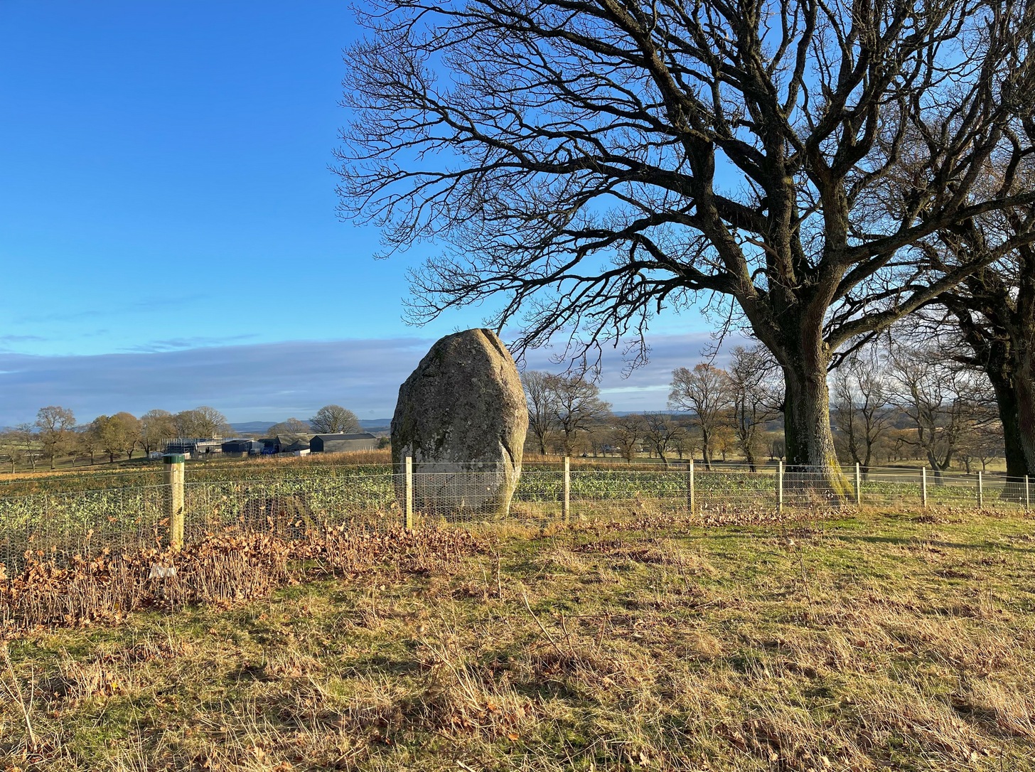
This is a bit of a hidden beauty! Standing nearly ten feet tall on the crest of an elongated ridge with the land ever so gently declining either side of its proud stand, it beckons the impression of partners long since gone (or something truly olde)… and so it proved to be. Very little has been written about the place, despite its impressive stature. It seems to have been described firstly in J.W. Thomson’s essay on the local parish in April 1837 (subsequently published in the NSA in 1845) where, ascribing it as usual to the druids of olde, he told that,
“at the western extremity of Logiealmond, there is one remarkable block about 12 feet high and 18 feet in circumference, standing upon its narrow end, with three other stones in its immediate vicinity. It is commonly called the Kor Stone.”
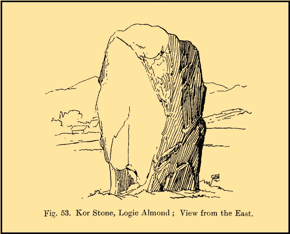
Kor Stone, looking SEFred Coles’ 1911 sketch
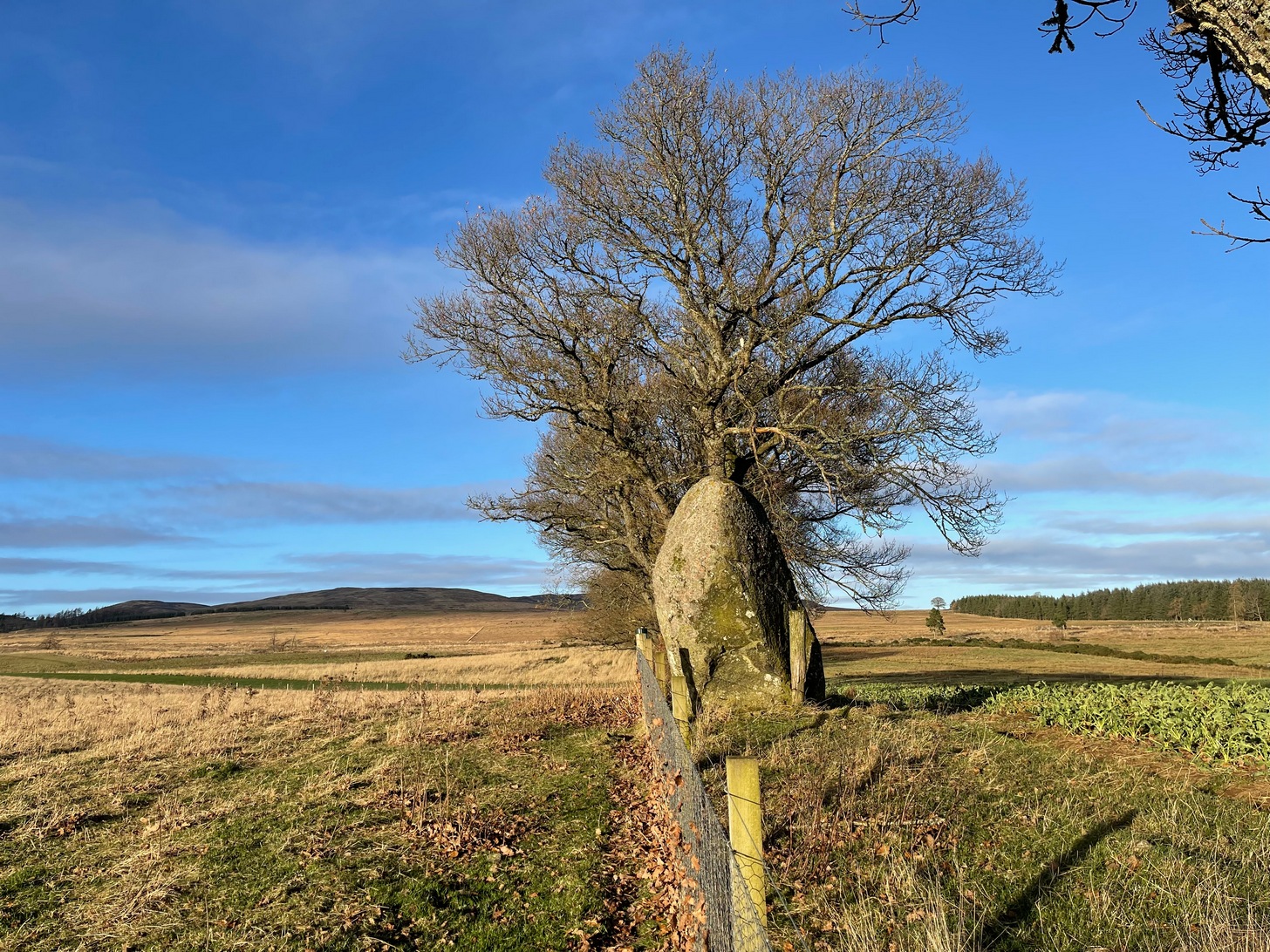
William Marshall (1880) also mentioned these three additional standing stones, saying that they were “apparently part of a row.” But they are long gone and we know not what became of them. They were probably uprooted and included in some of the nearby walling or buildings (quite a lot of suspicious-looking stones scatter the edges of many fields around Logiealmond). If we look closely at the surface of our Kor Stone, in earlier times someone has fixed metal loops into the monolith to make it part of an early fence or gate.
The stone was highlighted on the 1867 OS-map of the area and described in the accompanying Name Book,
“Carse” Stone on 1867 map
“A stone about ten feet high, supposed by some people to be the remains of a Druidical Circle, by others to be a mark on a division of lands: in support of the latter supposition they bring forward the fact of a large stone at Dunkeld and one near Fowlis – both similar to this one – and The Carse Stane being in the same straight line.”
The great Fred Coles (1911) also gave the place his attention, but apart from a brief description of its size and position, he found no additional lore about the other three stones, telling us simply:
“It is an imposingly large and erect block of rugged whinstone, 9 feet 9 inches in height, with a basal girth of 15 feet 10 inches, but at about midway of its height the girth increases to fully 17 feet. The view…shows the Stone as seen from the east.”
In truth, the location of this giant stone on the ridge strongly suggests it was once part of a much greater megalithic neolithic monument. But whatever that might have looked like, we may never know. It’s an awesome site though. Well worth checking out if you’re in the area.
Finlayson, Andrew, The Stones of Strathearn, One Tree Island: Comrie 2010.
Marshall, William, Historic Scenes in Perthshire, William Oliphant: Edinburgh 1880.
Thomson, J.W., “Parish of Moneydie,” in New Statistical Account of Scotland – volume X: Perth, William Blackwood: Edinburgh 1845.
Acknowledgements:Huge thanks for use of the Ordnance Survey map in this site profile, reproduced with the kind permission of the National Library of Scotland.
Stone Circle (destroyed): OS Grid Reference – NO 0015 2411
Also Known as:
Skelfie
Archaeology & History
Sometime between the end of the 19th and beginning of the 20th century, a Perthshire architect by the name of Thomas Ross was informed by a farm-worker called John Lawson who lived at Meckphen, that a stone circle had existed at Bachilton, but which had been destroyed when he was young. The information was gained by the great Fred Coles (1910) during his extensive survey work in and around Perthshire, but all trace of the site had gone when he came to write about it. He told us simply:
“Many years ago, several Stones of a Circle stood here, upon what appeared to be an artificial, and quite distinct mound which is still visible. The Stones were, however, undermined and buried, so as to be out of the reach of the plough, close to their respective sites.”
All subsequent searches for the site have proved fruitless and the circle’s long gone.
From the Askwith Moor car-park (SE 1757 5067), walk along the road north for several hundred yards and go through the gate on your right. Head northeast through the heather to the Death’s Head carving and keep along the same direction for barely another hundred yards onto the ever-so-slight crown of a small hillock. This is a hut circle you’re standing in/on. A few yards away just to the southeast of where you’re standing is the very denuded remains of this ring cairn.
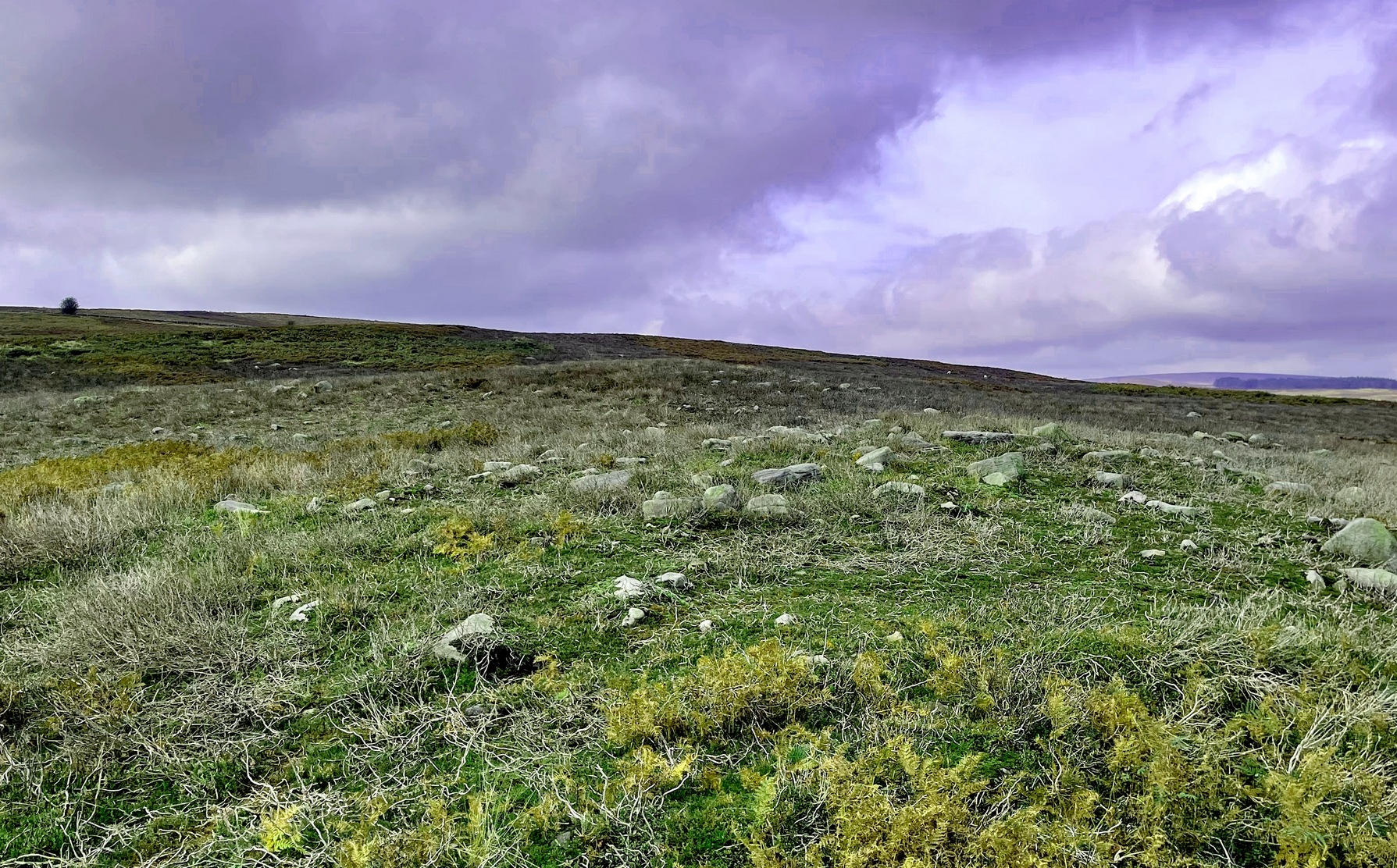
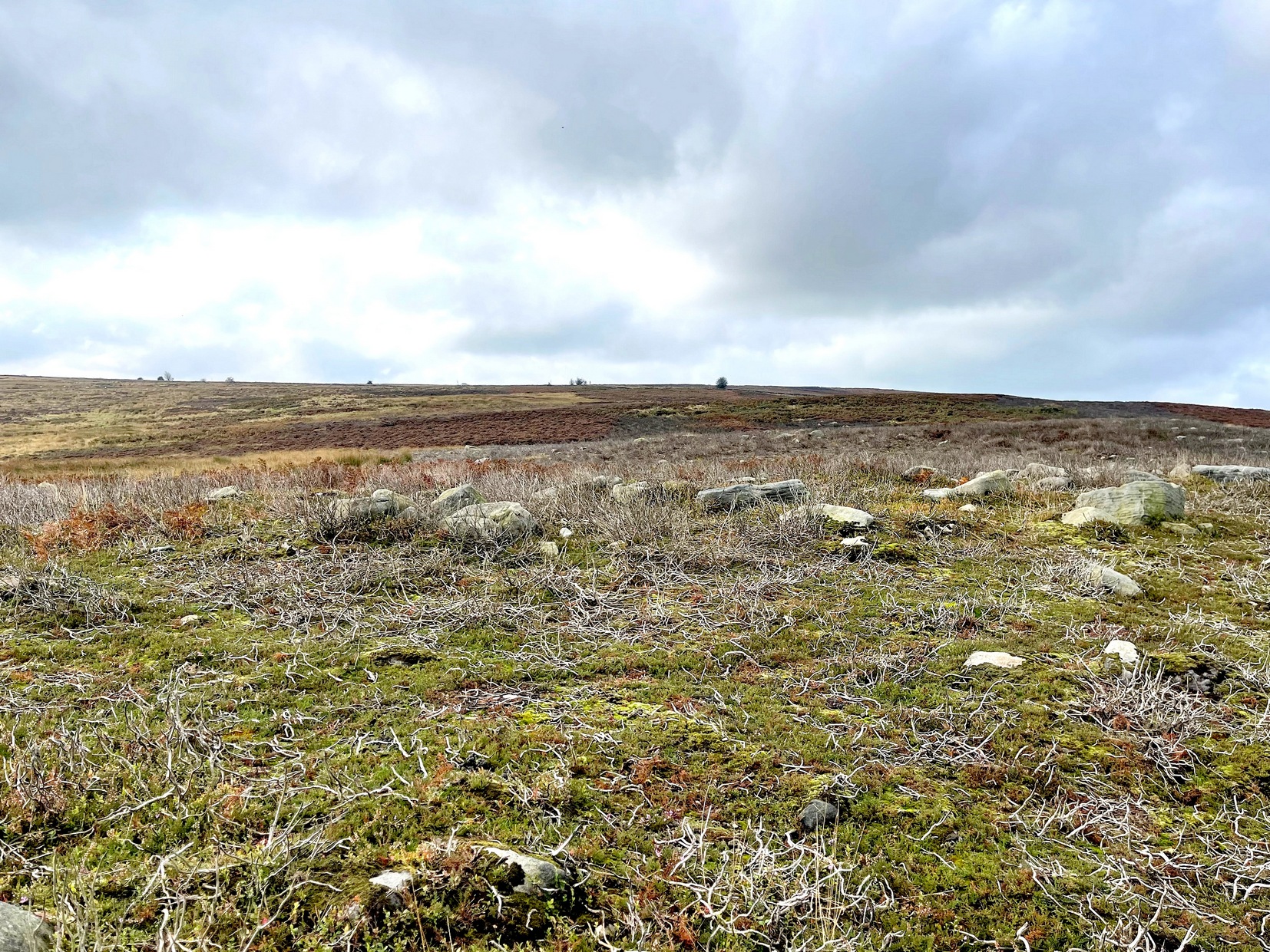
Archaeology & History
Low remains of rubble wall
Not visible when the heather’s in full growth, it’s nonetheless worth visiting if you’re trying to get a picture of the prehistoric landscape hereby. Less than 10 yards southeast of the notable hut circle on the small crown of a hill, it was first noticed by Sarah Walker on a group visit here recently. Roughly 12 yards across, the most notable section of the circle is the remains of the rubble bank on its east and southeastern sides, raised a few feet above ground level. The majority of the monument comprises of a scatter of various rocks and small stones within and round the edges of the circle. There’s a lot of scattering from other adjacent remains, such as the hut circle and nearby walling, that give the initial impression of it being little more than a spurious mess of stone; but the more you walk around and inside it, the more you come to recognize its structure.
It has that Bronze Age hallmark look about it, but without an excavation this is just educated guesswork. It might actually be older. The widespread mass of prehistoric remains all round here shows that it was once a mass of activity in prehistoric times. It’s a brilliant area, even if you can’t find this particular site!
Stone Circle (destroyed): OS Grid Reference – NN 88808 19823
Archaeology & History
In 1995, an aerial survey done in this neck o’ the woods found a number of distinct shadows in the landscape showing a considerable number of unrecorded prehistoric archaeological sites. One of them indicated a previously unrecognized “four poster” stone circle. It was described briefly on Canmore as follows:
“The four-poster is visible (as) a square setting 6m across. It is situated between the cropmarks of a palisaded settlement…and a possible enclosed settlement.”
No excavation has yet been performed. A very clear ring ditch was also discovered some 50 yards to the east in the same field.
Folklore
There is no known folklore or traditions relating to this site or immediate locale.
References:
Burl, Aubrey, Four Posters: Bronze Age Stone Circles of Western Europe, BAR 195: Oxford 1988.
Standing Stone (destroyed): OS Grid Reference – NN 8655 2079
Archaeology & History
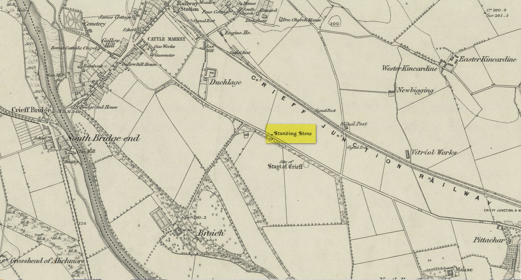
Site on the 1866 map
There is seemingly no trace left of this once impressive tall, slender standing stone that had lived for thousands of years on the south-side of Crieff. It was destroyed by some retard in the middle of the 20th century (anyone know their name?). Highlighted on the 1866 Ordnance Survey map of the area, it was visited and described by the late great Fred Coles (1911) when it still stood at the side of the road. He told that it was,
“In shape a narrow rhomboid at the base, this Stone rises to an acute angle at a height of 6 feet. Its longer axis is E.S.E. 52° by W.N.W. 52°, and in basal girth it measures 8 feet 11 inches.”
Coles’ 1911 sketch
Some 200 yards to the south-east there used to be the curiously-named Stayt of Crieff burial mound which had been used as a court hill for many centuries. This outlying standing stone may have been the “witness” on which oaths were sworn before the court. Sadly the history of the Stayt of Crieff mound is also somewhat sparse and it too has, appallingly, been destroyed. The destruction of these antiquities and their ancient traditions is nothing short of a fucking disgrace.
Finlayson, Andrew, The Stones of Strathearn, One Tree Island: Comrie 2010.
Acknowledgements:Huge thanks for use of the Ordnance Survey map in this site profile, reproduced with the kind permission of the National Library of Scotland.
Stone Circle (destroyed): OS Grid Reference – NO 5414 6935
Archaeology & History
Site location in 1863
Entered in Aubrey Burl’s (2000) magnum opus as a stone circle, the site has also been reclassified as a ring cairn or cairn circle, for obvious reasons. We can haggle about definitions if we wanna get a bit anal about it, but even from what little we know, this was an impressive looking site to say the least! Burl (1976) originally suggested that it may have been a recumbent stone circle: an Aberdeenshire outlier, so to speak—and he may have been right. Sadly the place has been destroyed, like so many megalithic rings in this neck o’ the woods.
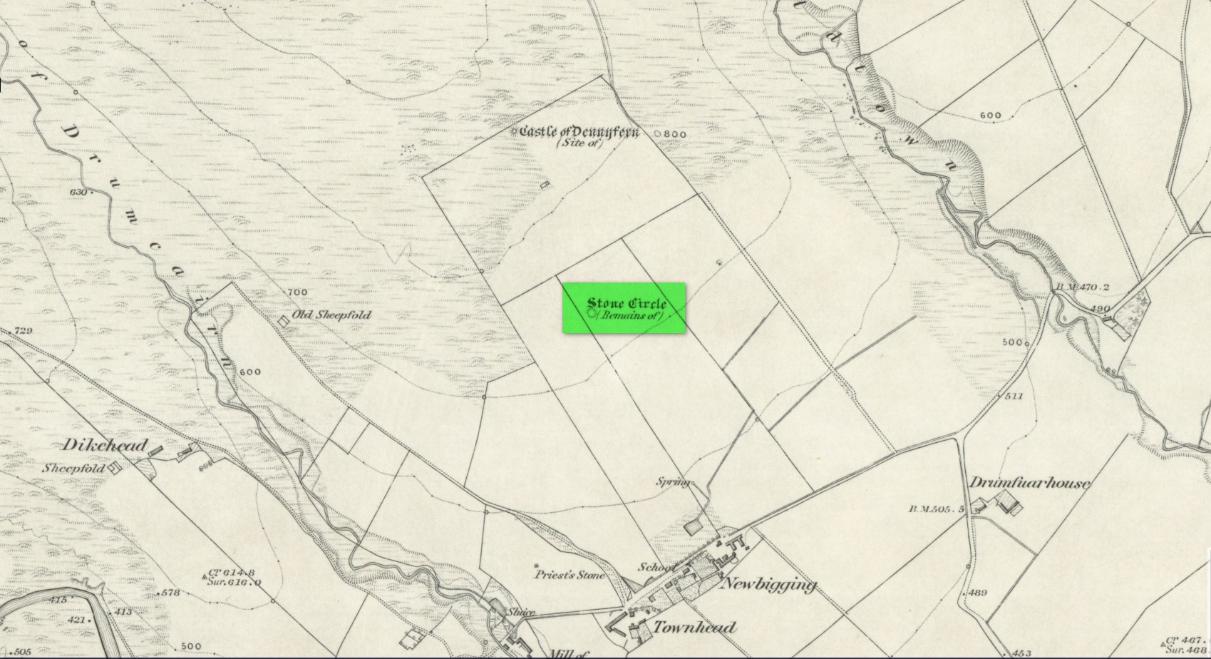
It was first mentioned, albeit briefly, by Alexander Gardner in his 1843 summary of the parish in the New Statistical Account where he told that, “there are the remains of a Druidical Temple at Newbigging near the remains of an ancient Castle or Tower called Dennyfern.” Our main source of information comes via the early Ordnance Survey lads after they’d visited the place in 1861. They wrote:
“Though nothing now remains of this Circle but one very large upright stone, measuring 5 feet 4 inches high, 9 feet in circumference at the base, and 6 feet 3 inches at the top, yet its site is plainly traceable, and is slightly raised from the ground around it. It was an immense Cairn, 40 feet in diameter according to the farmer of Newbigging, containing 400 cartloads of stones which he removed …The one Stone standing is so large that this may be considered to be the remains of a “Stone Circle” of which the large quantity of small stones formed the raised plateau, the ring of which is still visible.”
The great regional historian Andrew Jervise (1853) culled a few extra snippets of information about the place, telling us:
“Some fifty years ago, a good specimen of concentric circles stood on the farm of Newbigging, about half-a-mile north of the house, on an elevated part of the mountain; but, of the twenty or thirty large stones that enclosed an area of from fifty to sixty feet in diameter, only one remains, the rest having been carried away for various utilitarian purposes. This boulder, which is about eight feet high, is sometimes called the Druidical, but more commonly the “Stannin’ Stane of Newbiggin’,” and many flint arrow-heads have been found in its vicinity. When demolished, the middle of the area of the inner circle was found to be filled with small stones to the depth of about three feet, under which lay a quantity of black clammy earth, mixed with pieces of charcoal, while a track about two feet broad, composed of loose red sandstone, laid to the depth of a few inches, ran directly through the clammy earth and pebbles, from side to side of the outer circle.”
Alex Warden (1884) mentioned the remaining Stannin’ Stane of Newbiggin’ in his survey of the area, and the monolith was still in place when Cruikshank (1899), the local minister, wrote his detailed history book, but he added little more by way of Jervise’s description, merely telling that the stone circle
“on Newbigging must have been in its original state interesting and remarkable. It was composed of upright stones of great size, as we can see by the only one now remaining, which is known as “the Stannin’ Stane of Newbiggin’.” The blasted massive remains of the other stones form the foundation of the field dyke close by.”
It’s obvious that Burl’s idea that this circle was a recumbent one is based on Jervise’s description of it being “a good specimen of concentric circles” with the internal cairn structure giving it additional archaeomythic clout. Its complete destruction prevents us knowing anything more.
References:
Barnatt, John, Stone Circles of Britain– volume 2, BAR: Oxford 1989.
Burl, Aubrey, The Stone Circles of the Britain Isles, Yale University Press 1976.
Burl, Aubrey, The Stone Circles of Britain, Ireland and Brittany, Yale University Press 2000.
Cruikshank, F., Navar and Lethnot: The History of a Glen Parish in the North-east of Forfarshire, Black & Johnston: Brechin 1899.
Jervise, Andrew, The History and Traditions of the Land of the Lindsays in Angus and Mearns, Sutherland and Knox: Edinburgh 1853.
Royal Commission on the Ancient and Historical Monuments of Scotland, The Archaeological Sites & Monuments of Central Angus, Angus District, Tayside Region, HMSO: Edinburgh 1983.
Warden, Alex J., Angus or Forfarshire: The Land and People – Descriptive and Historical – volume 4, Charles Alexander: Dundee 1884.
Acknowledgements:Huge thanks for use of the Ordnance Survey map in this site profile, reproduced with the kind permission of the National Library of Scotland.
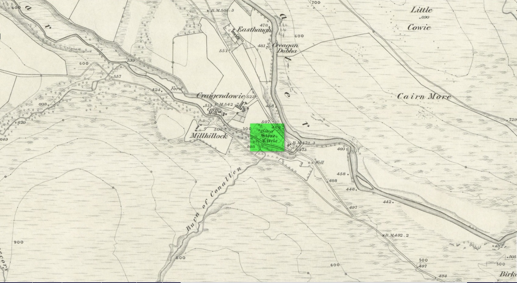
Stone Circle (destroyed): OS Grid Reference – NO 5225 6924
Archaeology & History
Site shown on 1865 map
All remains of this stone circle have long since bitten the dust. It was already described in the past tense when Alexander Gardner wrote his summary of the parish in the New Statistical Account in 1843 where he told that, “there are the remains of two or three small Druidical temples, one at Newbigging, one at Blairno, and one said to have been at Craigendowie, but now demolished.”
A few years later Andrew Jervise (1853), in his classic tome on the Mearns, gave us the best description of the place, based either on his own personal visit here, or one given to him by a local when he was surveying the history of the area. He wrote:
“In the vicinity of Craigendowie … among the mass of artificial-looking cairns (which are said to be the graves of warriors), there was a small circle, composed of a quantity of stones about the same size, and ranged in the same manner, as those at Fernybank…. Unlike the latter, this circle was never thoroughly explored, even at the time of its removal more than forty years ago, and if as old as prehistoric times, it cannot now be said in how far it may have been a place of sepulture. Craigendowie has, perhaps, its true etymon in the Gaelic Craigandubh, or “the black rock,” for the craig is an immense black rock close by the river-side; but, according to a truer etymology, as well as popular story, it implies the “rock of the funeral cairn,” or perhaps the “craig of battle or mischief;” and, if any reliance can be placed on the tales regarding the malicious actions of the kelpie in the dark pool beside it, or in the story of warriors having fallen in the neighbourhood, the latter rendering may not be altogether inept!”
When the Ordnance Survey lads wrote about it their Name Book (1861) they told simply of its memory, saying,
“There is now nothing remaining to mark the site except a portion of the ground being still uncultivated, nor is there any person who recollects seeing any remains. It is supposed to have been demolished in making an old road through it, the track of which is still plain.”
And, later still in Cruikshank’s (1899) major work on Lethnot township he added little extra information other than saying that “it was situated in the field in front of the farmhouse (but) is entirely destroyed.”
References:
Cruikshank, F., Navar and Lethnot: The History of a Glen Parish in the North-east of Forfarshire, Black & Johnston: Brechin 1899.
Jervise, Andrew, The History and Traditions of the Land of the Lindsays in Angus and Mearns, Sutherland and Knox: Edinburgh 1853.
Royal Commission on the Ancient and Historical Monuments of Scotland, The Archaeological Sites & Monuments of Central Angus, Angus District, Tayside Region, HMSO: Edinburgh 1983.
Warden, Alex J., Angus or Forfarshire: The Land and People – Descriptive and Historical – volume 4, Charles Alexander: Dundee 1884.
Acknowledgements: Huge thanks for use of the Ordnance Survey map in this site profile, reproduced with the kind permission of the National Library of Scotland.
Stone Circle (destroyed): OS Grid Reference – NX 693 709
Archaeology & History
In March 1844, Rev. W.G. Crosbie in his survey of the parish of Parton, mentioned the mediaeval earthworks, or motte, above the west side of the Borland Glen:
“At a short distance from this,” he wrote, “are the remains of a small Druidical circle.”
This “Druidical circle” was subsequently described in Fred Coles’ (1895) megalithic survey of Kirkcudbrightshire, where he added that the circle was “some two hundred yards distant” from the motte—but it had already been destroyed when he wrote about it and its exact location seems to have been forgotten. Logic suggests that the circle would have been on the lands immediately west of the motte, where the land is relatively level and possesses several small hillocks, which would be perfect for megalithic siting. (the grid-reference cited above is an approximation)
References:
Burl, Aubrey, The Stone Circles of Britain, Ireland and Brittany, Yale University Press 2000.
Coles, Fred, “The Stone Circles of the Stewartry of Kirkcudbright”, in Proceedings Society Antiquaries, Scotland, volume 29, 1895.
Crosbie, W.G., “Parish of Parton,” in New Statistical Account of Scotland – volume 4, William Blackwood: Edinburgh 1845.
Stone Circle (destroyed): OS Grid Reference – NO 220 416
Archaeology & History
In the first volume of the Royal Society’s Committee on Boulders (yes, there was such a thing!) that was read in April 1872, a megalithic ring was described that stood on the north side of the River Isla, above Coupar Angus. It was told that the minister of Bendochy, Dr Barty, reported to the committee, that
“on the rising ground behind his manse, there was a circle of large stones, boulders, standing on their ends (Druidical); but some years ago they were removed. The place is yet called ‘The Nine Stanes.'”
Despite its destruction, in recent times aerial photography has identified a number of features in the field above the manse, including what seems to be an enclosure and some disc-shaped cropmarks. One of these may be the shadow marks of the circle.
References:
Home, David Milne, First Report by the Committee on Boulders, Royal Society Edinburgh 1872.
Stone Circle (destroyed): OS Grid Reference – NT 474 548
Archaeology & History
Included in Aubrey Burl’s (1976) first gazetteer, without comment, the site was subsequently added to John Barnatt’s (1989) magnum opus. He tells that in the 19th century, “early Ordnance Survey records…note a destroyed stone circle” here, but draws a somewhat sceptical opinion of its very existence as “the Ordnance Survey frequently made mistaken interpretations in the 19th century and hence this should be treated with caution.”
Despite this, early local historians refer to the site, albeit in the past tense. The first would seem to have been Walter Elliot (1869) in his address to the respected Berwickshire Naturalists Club. Some members of this group had visited a number of ancient sites the previous year:
“A camp above Channel Kirk was also indicated, near which a stone circle formerly existed, but it has been destroyed and the materials used for building dykes within the last five or six years.”
The “camp” was an old Roman one which has itself been almost completely destroyed, despite it still being shown on modern OS-maps.
The circle was mentioned in passing in Mr Thomson’s (1902) huge work on his descriptions of the many local hillforts. Close to one at Kirktonhill known as the Roman or Agricola’s Camp, “forty years ago, there was said to have been a stone circle.” This was reiterated in Craw’s (1920) survey of prehistoric monuments in Berwickshire.
Perhaps the most curious omission is in Mr Allan’s (1900) huge survey on Channelkirk parish. His description of the Roman camp was considerable, but he made no mention of an adjoining circle. The best we got from him was a vague allusion about some ancient pre-christian site not far from the church, when he wrote:
“Whether or not some rude form of a place of worship might then exist on the spot where now a church has stood for so long it were rash to assert, but there are certain indications that some particular place, specially marked as consecrated to religious rites, was then a local possession.”
(it should be noted that the Canmore entry for this site has its location at the prehistoric camp due west of Kirktonhill, which is incorrect)
References:
Allan, Archibald, History of Channelkirk, J. Thin: Edinburgh 1900.
Barnatt, John, Stone Circles of Britain– volume 2, BAR: Oxford 1989.
Burl, Aubrey, The Stone Circles of British Isles, Yale University Press 1976.
Burl, Aubrey, The Stone Circles of Britain, Ireland and Brittany, Yale University Press 2000.
Elliot, Walter, “Anniversary Address Delivered at Berwick on the 30th of September, 1869,” in History Berwickshire Naturalists Club, volume 6, 1869-72.
Thomson, A., Lauder and Lauderdale, Craighead Brothers: Galashiels 1902.