Dave’s Stone, Rivock, Riddlesden, West Yorkshire

Cup-Marked Stone:  OS Grid Reference – SE 07634 44209

Getting Here

Rock with cup-markings

From the B6265 valley road between Bingley and Keighley, just near Riddlesden Hall, take the road up and over the canal into Riddlesden, bearing left up past West Riddlesden Hall and up Banks Lane. As you reach the T-junction at the top, where you hit the Silsden Road that goes round the moors, park up. Takes the footpath across the road and walk straight uphill, all the way to the top just above where the tree line ends and you’re on the moorland flat.  Bear right, over one wall, then walk 20-30 yards further and the stone in the photo here should be roughly under thine nostrils!

Archaeology & History

There’s no previous record of this as a cup-marked stone, so it needs adding here.  I’ve gotta admit that I’m not 100% sure about it as a real prehistoric carving — but considering the dubious nature of the nearby Carving no.58 and the Rivock Nose Stone, this is roughly somewhere in-between in terms of its legitimacy as an ancient carved stone.  Certainly I’ve come across other cup-markings, adjudged by newly-qualified ‘professionals’ as fine, but which I find highly questionable — so this one that Dave Hazell came across a couple of years ago should certainly be added to their professional rock art catalogues.

Close-up of the cupmarks

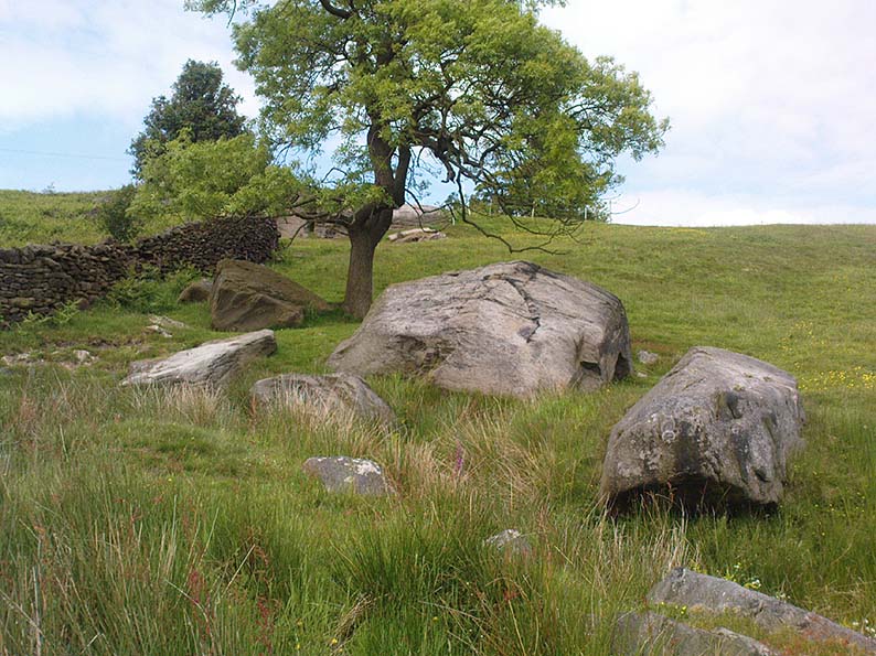
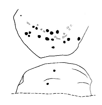
It’s simple enough: a four-feet long stone, whose top east-facing edge has been worked in more recent centuries by the miners who dug on the slopes below (perhaps to turn it into a gatepost?).  There are three notable ‘cups’ that are clearly visible on the photos here.  The topmost cup is something pretty recent, having had industrial attention given it; the largest cup may be natural; but the one in the middle seems to be what our English Heritage rock-art enthusiasts term a legitimate prehistoric petroglyph.  It certainly seems a good one!  Have a look for yourself and see what you reckon! It’s in a good spot and is certainly worth the wander, if only to have a look at other cup-and-rings in the region.

© Paul Bennett, The Northern Antiquarian


Rivock Edge (60), Silsden, West Yorkshire

Cup-and-Ring Stone:  OS Grid Reference – SE 07476 44475

Also Known as:

  1. Carving no.22 (Hedges)
  2. Roof Stone

Getting Here

Cup-mark on top of the rock

From the B6265 valley road between Bingley and Keighley, just near Riddlesden Hall, take the road up and over the canal into Riddlesden, bearing left up past West Riddlesden Hall and up Banks Lane. As you reach the T-junction at the top, where you hit the Silsden Road that goes round the moors, park up. Cross the road and follow the footpath up the field, but walk up the side of the field-wall where the woods are, all the way to the top. On the flat, you’ll see a gap in the woods on your left, and the triangulation pillar atop of Rivock Edge 150 yards away.  Head towards it, watching out for one of the natural rocks rising near the middle of the grasses. It’s one of them!

Archaeology & History

Faint cup-and-ring, centre of photo

Exactly halfway between the cup-marked Niplet Stone and the large flat Carving 58 (Boughey & Vickerman survey) is this natural long upright rock, shaped in the form of a house-roof, with its apex running along an axis SE-NW, its sloping sides dropping either side into the deep wet heather.  Upon its crown is what may be a singular cup-marking, almost perfectly formed, though is just as likely to be Nature’s handiwork as much as anything else.  But on its western-face, within the mass of old lichen painting the rock surface, a more distinct man-made cup-mark has been cut.

On its eastern face, close to where the rock meets the boggy Earth, a singular faint cup-and-ring design can be made out, albeit a somewhat mis-shapen one.  It’s easily missed if the lighting isn’t too good as it’s very eroded indeed.  The carving was first described in Mr Hedges (1986) survey, where he told:

“Rough grit rock with ridge, in crowberry and heather with cup and ring on E edge and possible cups and grooves.”

The stone’s certainly worth visiting, as a number of other cup-and-ring stones scatter this region — half of them officially recorded, but nearly as many again that aren’t.  It’s a good area to explore.

References:

  1. Bennett, Paul, “The Prehistoric Rock Art and Megalithic Remains of Rivock & District (parts 1 & 2),” in Earth, 3-4, 1986.
  2. Boughey, Keith & Vickerman, E.A., Prehistoric Rock Art of the West Riding, WYAS 2003.
  3. Hedges, John (ed.), The Carved Rocks on Rombald’s Moor, WYMCC: Wakefield 1986.
  4. Morris, Ronald W.B., “The Prehistoric Rock Art of Great Britain: A Survey of All Sites Bearing Motifs more Complex than Simple Cup-marks,” in Proceedings of the Prehistoric Society, volume 55, 1989.

© Paul Bennett, The Northern Antiquarian 


Rivock Edge (58), Silsden, West Yorkshire

Cup-Marked Stone:  OS Grid Reference – SE 07466 44497

Also Known as:

  1. Carving no.21 (Hedges)

Getting Here

Take the same directions as if you’re visiting the Rivock Edge 060 Carving.  It’s 25 yards NNW – you can’t really miss it!

Archaeology & History

Rivock Edge, carving 58

This large flat rock, with a couple of long lines almost splitting the rock into sections, was first mentioned as a prehistoric site in John Hedges (1986) survey, where he described it simply as, “Large rough grit rock with possible four cups, in crowberry.” Boughey & Vickerman (2003) said even less about it!  One of the cups is very distinct, but the others are somewhat faded and perhaps even dubious.  It’s still worth a look at, if only due to the other better carvings nearby.

References:

  1. Bennett, Paul, “The Prehistoric Rock Art and Megalithic Remains of Rivock & District (parts 1 & 2),” in Earth, 3-4, 1986.
  2. Boughey, Keith & Vickerman, E.A., Prehistoric Rock Art of the West Riding, WYAS 2003.
  3. Hedges, John (ed.), The Carved Rocks on Rombald’s Moor, WYMCC: Wakefield 1986.

© Paul Bennett, The Northern Antiquarian 


Split Rock, Rivock, Keighley, West Yorkshire

Cup-and-Ring Stone:  OS Grid Reference – SE 07989 44208

Also Known as:

  1. Carving no.39 (Hedges)
  2. Carving no.80 (Boughey & Vickerman)

Getting Here

Split Rock, Rivock
Split Rock, Rivock

Head up to Rivock’s Wondjina Stone carving, then keep going east to the Long Rock.  Wander 100 or more further east till you see the fence, and about 50 yards before this check out the large rocks which you’ll notice near to each other.  One of them is this Split Rock!

Archaeology & History

First described in Hedges’ (1986) survey, this is a large flattish boulder, split across one side, with two distinct cup-marks on its eastern side and a number of other ‘possibles’ scattering the surface.  The most intriguing bit to this rock is on its lower eastern side.  Here’s what Boughey & Vickerman (2003) described as,

CR80-2
Deep cup-and-half-ring

“one clear cup (doubtful) discovered under turf…at extreme lower SE corner, with possible attempt at pecked partial ring.”

This cup they describe as “doubtful” is quite deep, but the half-ring on its northern side has definite artificial peck-marks.  I’m more of the opinion that this cup-and-half-ring is man-made — though whether it was done in more recent years is the more debatable aspect here.  I’ll try getting some better images (and a drawing) of this stone when we’re next up here.

References:

  1. Boughey, Keith & Vickerman, E.A., Prehistoric Rock Art of the West Riding, West Yorkshire Archaeology Service 2003.
  2. Hedges, John, The Carved Rocks on Rombalds Moor, WYMCC: Wakefield 1986.

© Paul Bennett, The Northern Antiquarian


Long Stone, Rivock, Keighley, West Yorkshire

Cup-Marked Stone:  OS Grid Reference – SE 07833 44313

Also Known as:

  1. Carving no.78 (Boughey & Vickerman)

Getting Here

Head up to the lovely Wondjina Stone carving, then walk east towards the triangulation pillar. Keep going, over the wall – and keep going straight on, over the next wall (no footpaths up here at all).  You’re now into rough heathland, but if you’re a real cup-and-ring freak, keep heading another 150 yards east, zigzagging slightly.  You’ll eventually find it!

Archaeology & History

CR78
Long Rock carving, Rivock

A quite large, smooth earthfast rock, but nowt much to look at unless you’re one of the crazy bunch!  This is just another one of our basic cup-marked rocks with very little modern archaeo-history attached.  There are perhaps as many as four cup-markings etched onto the stone: two at the northern end, one a little further down (not mentioned in Boughey & Vickerman’s survey) and another one cited towards the south end of the stone.  Gotta be honest though: a couple of them are slightly dubious and may be natural — but hopefully not! (soz about the crap photo of this poor carving; but the light was shit & our camera packed-up!)

References:

  1. Boughey, Keith & Vickerman, E.A., Prehistoric Rock Art of the West Riding, West Yorkshire Archaeology Service 2003.

© Paul Bennett, The Northern Antiquarian


Ant’s Stone, Rivock, Keighley, West Yorkshire

Cup-Marked Stone:  OS Grid Reference – SE 0791 4422

Archaeology & History

Ant Stone, uncovered

Discovered today, amidst a cluster of other carvings not previously catalogued.  This was hidden beneath a mass of vegetation, but after cutting and digging into the peat on top of the stone, several cup-marks became evident.  By the side of the rock, measuring roughly 8 feet by 5 feet, was a small ant’s nest — hence the convenient name of the carving.

Central design of the carving

The main feature is the large, perhaps natural cup-mark, about 3 inches across.  But three distinct artificial cup-markings were etched around the edges of this larger ‘cup’.  When we found this stone, the daylight was nearing its end and we were unable to ascertain any further features carved onto the rock.  Several other carvings were close by, none of which were included in the survey by Boughey and Vickerman. (2003)  After we’d finished here, we covered the stone back over with its peaty quilt and hoped that the ants weren’t too pissed off about us disturbing them…

© Paul Bennett, The Northern Antiquarian 


Robin Hood’s Stone, Riddlesden, West Yorkshire

Legendary Rock:  OS Grid Reference – SE 06228 44470

Getting Here

Marked on the 1853 OS-map

Dead easy!  If you come from Silsden, take the Holden Road up onto the moor edge, all the way up the wooded hill.  As you reach the top, keep your eyes peeled for the stone in the slope to your left.  Otherwise, coming from Riddlesden, take the moor road upwards (to Silsden Road) as if you’re gonna visit Peggy Mawson’s Well, the Baldwin Stone or some of the Rivock carvings.  Keep on the road to where you see the microwave tower on Pinfold Hill to your right.  It’s just below it!

Archaeology & History

Robin Hood’s Stone from above

Flints have been found on the slopes above here, but records of this stone only go back — as far as I’ve found — to 1850 (this seems to typify records around the Keighley district, which only seems to record anything post-1500 AD).  In mid-Victorian times, plans were afoot to use the rock for building material, but local people objected and so the stone kept its position overlooking the valley.  There are a number of very defined ‘cups’ on the sloping face of the stone, but several (though not all) of these have all the likeness of the holes dug into the rock by climbers — though why climbers would even think to cut foot-holes into this easy rock beggars belief!

Folklore

One of several sharp well-defined 'cups' on the rock
One of several sharp well-defined ‘cups’ on the rock

Not too surprisingly, folklore tells that this stone was one of the places where our old hero Robin Hood sheltered, when being chased by god-knows-who in one of his many exploits.  We’ve no way of proving this of course, but the sparse woodland remains above here also bear the hero’s name.  What seems to be a more modern piece of industrial folklore alleges that this stone was actually put here by workers in the Victorian times!  The boulder allegedly lived near Barden, Bolton Abbey, but was blocking construction work, so was uprooted and moved all the way to where it now sits!  In bygone times the rock was a local meeting place – perhaps around Beltane, in line with Robin Hood festivities.

References:

  1. Gray, Johnnie, Through Airedale from Goole to Malham, Elliot Stock: London 1891.

© Paul Bennett, The Northern Antiquarian


Peggy Well, Silsden, West Yorkshire

Healing Well:  OS Grid Reference – SE 0655 4413

Also Known as:

  1. Peggy Mawson’s Well
  2. Peggy’s Well

Getting Here

Peggy Mawson’s Well on 1853 map

From Riddlesden, take the road up to the moorland and Rivock Edge.  When you reach the top (Silsden Road), turn left.  Go on for about 600 yards till you reach the lovely tree-hidden old cottages of Holden Gate, on your right.  Stop — and walk down the footpath opposite from here.  As the wall goes down, you’ll notice a stream in the next field to your left, emerging from a clump of large rocks.  That’s it! (there’s a footpath in the next field from the roadside)

Archaeology & History

Shown on the first OS-map as ‘Peggy Mawson’s Well,’ little else seems to known of this place; though it obviously got its name after the local lady, Peggy Mawson.  I can find no further information about this lady, nor why the site was named after her.  Any help here would be hugely appreciated!

Peggy Mawson’s Well – now drained-off through pipes

Sadly the waters from beneath the rocks have been channeled into a couple of pipes and the well no longer runs.  All that’s left is a small boggy region just in front of the boulders.  You have to walk about 100 yards further down the field where the water emerges from a modern pipe.  It doesn’t taste as nice as it originally did when coming straight from the ground, but it’s still quite drinkable (certainly beats any of the chlorinated stuff* that customers are forced to pay for, whether we want it or not – and most people don’t want it).

Folklore

This site has acquired modern folklore, but sadly no early traditions have been found.  Whelan & Taylor (1989) thought that Peggy Well’s “dedication suggests a connection with St. Margaret,” which unfortunately isn’t the case.  Several years later another writer, Val Shepherd (1994), spun the speculation even further, not checking the historical background to the site, and thought that “the well’s name may be derived from the water spirit, ‘Peg,’ who gave her name to other wells.”  Sadly neither idea holds any sway.

References:

  1. Shepherd, Val, Historic Wells in and Around Bradford, HOAP: Loughborough 1994.
  2. Whelan, Edna & Taylor, Ian, Yorkshire Holy Wells and Sacred Springs, Northern Lights: Pocklington 1989.

* Anyone know about this: surely because the water companies chlorinate and add other undesirable toxins into our tap water, what we’re actually drinking is a very weak solution and not actually water.  Isn’t that a trading standards violation?

© Paul Bennett, The Northern Antiquarian


Rivock Nose (2), Keighley, West Yorkshire

Cup-Marked Stone:  OS Grid Reference – SE 07360 44629

Also Known as:

  1. Carving no.11 (Hedges)
  2. Carving no.46 (Boughey & Vickerman)

Getting Here

Follow the same directions for reaching the Wondjina Stone.  Once here, walk to the edge of the cliffs less than 10 yards away and the second largest of the rocks is the one you’re after. (the Rivock Nose [1] and [3] carvings are the rocks either side of this one)

Archaeology & History

Possible cup-markings at Rivock Edge

I’ve gotta admit, I was slightly surprised to find this carving logged in both Hedges (1986) and Boughey & Vickerman’s (2003) surveys.  Although we find the distinct appearence of cup-markings near the edge of the cliff at the northwestern end of Rivock Edge, these seem a little too close to being natural to be comfortably acknowledged in archaeo-texts without notes the contrary.  I took a photo of them when we were up visiting the other day, but didn’t expect them to be in the books.  Not only do they include this probably natural example, they also add another two rocks found along the cliff edges (Hedges 12 & 13; B&V 45 & 47).  In the event that these carvings are deemed authentic, then those along the edge of the great Kirk cliffs above Steeton must also be added to the same pot.

In the photo here you can work out perhaps nine cup-marks near the edge of the cliff, which is what the textbooks say.  Make your own mind up when your next looking at the Wondjina Stone and others nearby.

References:

  1. Boughey, Keith & Vickerman, E.A., Prehistoric Rock Art of the West Riding, WYAS 2003.
  2. Feather, Stuart, ‘Mid-Wharfedale Cup-and-Ring Markings: Nos. 7 & 8, Rivock Edge,’ in Cartwright Hall Archaeology Group Bulletin, 6:8, 1961.
  3. Hedges, John (ed.), The Carved Rocks on Rombald’s Moor, WYMCC: Wakefield 1986.

© Paul Bennett, The Northern Antiquarian 


Niplet Stone, Rivock, Keighley, West Yorkshire

Cup-Marked Stone:  OS Grid Reference – SE 07481 44452

Also Known as:

  1. Carving no.23 (Hedges)
  2. Carving no.59 (Boughey & Vickerman)

Getting Here

Niplet Stone (after Hedges)

Follow the same directions to reach the nearby Wondjina Stone, but as you reach the trig-point at the top of Rivock Edge, note the smooth rounded boulder 50 yards ESE.  That’s it!

Archaeology & History

Named after the sea of cotton grasses, or niplets (Eriophorum angustifolium), amidst which it lives for several weeks of the year, the cups-marks that make up this design can be terribly difficult to work out even in the best of lighting.  We have here a lichen-encrusted stone with perhaps as many as 25 cup-marks scattering, mainly, the top and westerly sloping face.  Although some of the cups are quite noticeable, the vegetative growth and simple erosion has made an accurate visual impression of the original carving very difficult — as the images plainly tell!  If I ever manage to capture the stone resting in a good mood, I’ll replace the photos I’ve got here!

Niplet Stone, looking SE
Beautiful fusion of faded cups, lichen & great age...
Beautiful fusion of faded cups, lichen & great age…

Although I remember coming here and seeing this and the nearby carvings when I was a teenager, then a few years later on with Edna Whelan and Graeme Chappell, it seems that the first literary note of this carving after my own initial exploration was in the Ilkley Archaeology Group’s survey (Hedges 1986), where they make note of a flint that was found beside the stone.  Boughey and Vickerman (2003) later include the same stone in their work, but with no additional information.

References:

  1. Bennett, Paul, “The Prehistoric Rock Art and Megalithic Remains of Rivock & District (parts 1 & 2),” in Earth, 3-4, 1986.
  2. Boughey, Keith & Vickerman, E.A., Prehistoric Rock Art of the West Riding, WYAS 2003.
  3. Hedges, John (ed.), The Carved Rocks on Rombald’s Moor, WYMCC: Wakefield 1986.

© Paul Bennett, The Northern Antiquarian