Split Rock, Rivock, Keighley, West Yorkshire

Cup-and-Ring Stone:  OS Grid Reference – SE 07989 44208

Also Known as:

  1. Carving no.39 (Hedges)
  2. Carving no.80 (Boughey & Vickerman)

Getting Here

Split Rock, Rivock
Split Rock, Rivock

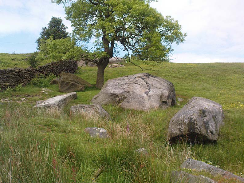
Head up to Rivock’s Wondjina Stone carving, then keep going east to the Long Rock.  Wander 100 or more further east till you see the fence, and about 50 yards before this check out the large rocks which you’ll notice near to each other.  One of them is this Split Rock!

Archaeology & History

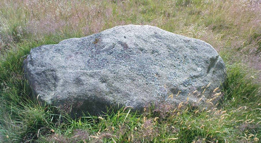
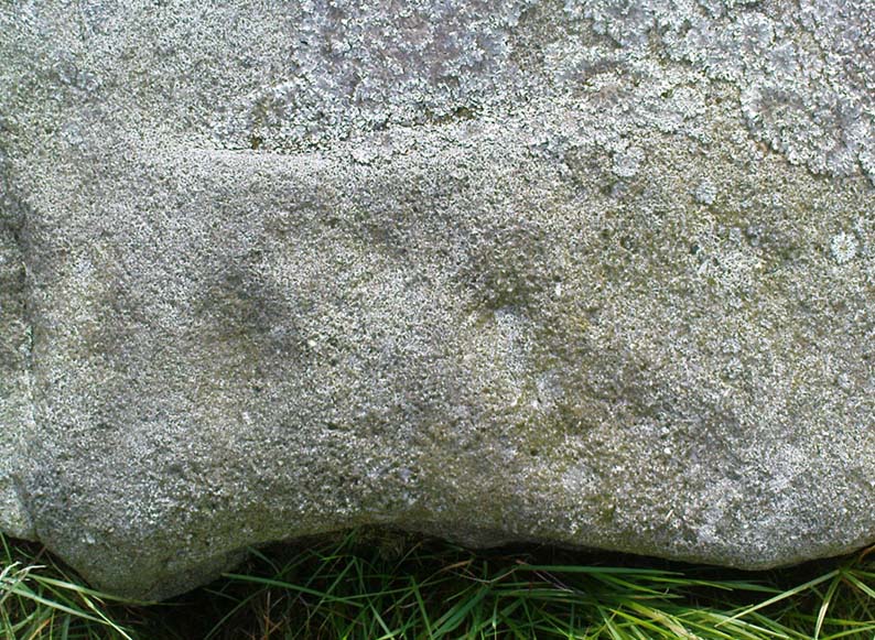
First described in Hedges’ (1986) survey, this is a large flattish boulder, split across one side, with two distinct cup-marks on its eastern side and a number of other ‘possibles’ scattering the surface.  The most intriguing bit to this rock is on its lower eastern side.  Here’s what Boughey & Vickerman (2003) described as,

CR80-2
Deep cup-and-half-ring

“one clear cup (doubtful) discovered under turf…at extreme lower SE corner, with possible attempt at pecked partial ring.”

This cup they describe as “doubtful” is quite deep, but the half-ring on its northern side has definite artificial peck-marks.  I’m more of the opinion that this cup-and-half-ring is man-made — though whether it was done in more recent years is the more debatable aspect here.  I’ll try getting some better images (and a drawing) of this stone when we’re next up here.

References:

  1. Boughey, Keith & Vickerman, E.A., Prehistoric Rock Art of the West Riding, West Yorkshire Archaeology Service 2003.
  2. Hedges, John, The Carved Rocks on Rombalds Moor, WYMCC: Wakefield 1986.

© Paul Bennett, The Northern Antiquarian


Long Stone, Rivock, Keighley, West Yorkshire

Cup-Marked Stone:  OS Grid Reference – SE 07833 44313

Also Known as:

  1. Carving no.78 (Boughey & Vickerman)

Getting Here

Head up to the lovely Wondjina Stone carving, then walk east towards the triangulation pillar. Keep going, over the wall – and keep going straight on, over the next wall (no footpaths up here at all).  You’re now into rough heathland, but if you’re a real cup-and-ring freak, keep heading another 150 yards east, zigzagging slightly.  You’ll eventually find it!

Archaeology & History

CR78
Long Rock carving, Rivock

A quite large, smooth earthfast rock, but nowt much to look at unless you’re one of the crazy bunch!  This is just another one of our basic cup-marked rocks with very little modern archaeo-history attached.  There are perhaps as many as four cup-markings etched onto the stone: two at the northern end, one a little further down (not mentioned in Boughey & Vickerman’s survey) and another one cited towards the south end of the stone.  Gotta be honest though: a couple of them are slightly dubious and may be natural — but hopefully not! (soz about the crap photo of this poor carving; but the light was shit & our camera packed-up!)

References:

  1. Boughey, Keith & Vickerman, E.A., Prehistoric Rock Art of the West Riding, West Yorkshire Archaeology Service 2003.

© Paul Bennett, The Northern Antiquarian


Ant’s Stone, Rivock, Keighley, West Yorkshire

Cup-Marked Stone:  OS Grid Reference – SE 0791 4422

Archaeology & History

Ant Stone, uncovered

Discovered today, amidst a cluster of other carvings not previously catalogued.  This was hidden beneath a mass of vegetation, but after cutting and digging into the peat on top of the stone, several cup-marks became evident.  By the side of the rock, measuring roughly 8 feet by 5 feet, was a small ant’s nest — hence the convenient name of the carving.

Central design of the carving

The main feature is the large, perhaps natural cup-mark, about 3 inches across.  But three distinct artificial cup-markings were etched around the edges of this larger ‘cup’.  When we found this stone, the daylight was nearing its end and we were unable to ascertain any further features carved onto the rock.  Several other carvings were close by, none of which were included in the survey by Boughey and Vickerman. (2003)  After we’d finished here, we covered the stone back over with its peaty quilt and hoped that the ants weren’t too pissed off about us disturbing them…

© Paul Bennett, The Northern Antiquarian 


Abacus Stone, Holden, Silsden, West Yorkshire

Cup-Marked Stone (lost):  OS Grid Reference – SE 060 440

Getting Here

This carving is somewhere between Rivock’s western woodland edge, into the meadowlands next to it, down towards Robin Hood’s Wood.  Good luck if you find it!

Archaeology & History

The lost Abacus Stone design

I found this carved ‘design’ when I was but a nipper, as they say!  I was up all day, bimbling abaat checking out the stones and stuff, with notepad and pencil and found a number of cup-marked stones that I hadn’t come across in Stuart Feather’s surveys (the Hedge’s [1986] survey hadn’t been published at the time).   I’ve been back up round the Holden and Robin Hood’s Wood district several times in recent months, hoping to re-locate this carving — but without success.  I recall that when I found it all those years ago, how the design itself seemed almost ‘numeric’ in quality to look at (hence its title) and was hoping to come across it again, but the little fella’s hiding away somewhere!

The faded design was etched onto a small, slightly raised natural  stone, no more than 3ft x 3ft and about 2 feet high.  I thought that it might have been Boughey & Vickerman’s carving number 53 (Hedges survey, no.17), but it wasn’t to be. If anyone finds it again, I’d love to know!

References:

  1. Bennett, Paul, Ramblings of Archaeological Remnants in West Yorkshire, unpublished: Shipley 1984.

© Paul Bennett, The Northern Antiquarian


Currer Woods Stone, Steeton, West Yorkshire

Cup-and-Ring Stone:  OS Grid Reference – SE 0251 4384

Getting Here

On the opposite side of the road (B6265) from Airedale General Hospital, Steeton, you’ll notice a footpath going up the field into some woods.  Go up here.  Once you come out the top of the woods, follow the dodgy path on your right (west) along the rocky edges for 250 yards, following the edges of the field walling.  You’ll eventually reach the field with lots of rocks in it.  It’s the field before this one, close to the walling.  Look around!

Archaeology & History

I’ve been a little cautious about putting this carving on TNA simply because it seems to be an isolated example and was a little unsure about its veracity.  If I’d have found the stone on the edges of Ilkley Moor, Rivock Edge, or the heights above Askwith, I wouldn’t have hesitated.  The fact that no other carvings occur nearby has been my main trouble.  But I suppose if the carving turns out to be nowt of the sort, I can discard it at a future date and, of course, make sure that a lot of other cup-and-ring stones are disregarded at the same time (there are a number of other designs much less defined than this one which have been okayed by archaeo’s who’ve been into this subject for much shorter periods of time than myself).  But less of the waffle!

Currer Wood Carving, Steeton

When we first found this, in April 2009, I was out looking for the remains of an old well (called Jane Well, a few hundred yards west of here).  The heaven’s opened and I ended up in the woodland and then found the field full of large rocks, some seemingly used by man in more recent centuries, atop of the woods, and so had to check them out!  But this was one of the first stones we found.

Currer Woods Stone
Currer Woods Stone

The rock itself, as the photo shows, appears to have had one end of it split or broken off (not unlike one edge of the Hanging Stones, Ilkley Moor) at some time in the past, intruding on the arc, or line, beneath which are two distinct ‘cups’.  A possible third cup-marking and other linear aspects seem apparent, with the design giving the distinct impression of a face.  I keep meaning to go back and get a rubbing of the carving, but aint got round to it yet.  When (if!) I gerrit done, I’ll add it onto this profile.

And although there are said to be no other prehistoric remains close to this old carving, the fields a coupla hundred yards west used to be called the Barrow Fields, where tombs were once found; and a little further along the same geological ridge atop of the excellent Kirk rocks, possible cup-markings scatter the edges of two sections — but they’re a little dubious; then there’s the Dragon Stone and associated cup-marked stone not far away.  In the adjacent woods are the remains of old walling, but I’ve not found other carvings hereabouts.  However, the rule tends to be: “where there’s one, there are more!”

Watch this space!

© Paul Bennett, The Northern Antiquarian


Pathway Stone, Holden, Silsden, West Yorkshire

Cup-Marked Stone:  OS Grid Reference – SE 07021 44884

Also Known as:

  1. Rough Holden CR-9

Getting Here

Pathway Stone, Holden, Rivock

Follow the footpath running from the Rivock TV mast northwest, where it cuts diagonally across the field, heading towards the drystone wall.  About 200 yards before the walling – stop! It’s just to your right-hand side, very close by!

Archaeology & History

First discovered in July 2009 when Keighley volunteer, Michala Potts of Bracken Bank, did further ramblings amidst the long grasses hereabouts.  Its name comes from the fact that it’s found just next to the footpath that cuts across Rough Holden from the TV mast beneath Rivock.  The carving’s a very simple plain design, as the photos show, with just three faded cup-markings etched onto the stones northeast face.

Close-up of cup-markings

This stone aint too far from the cup-marked Dump Stone and the nearby Rough Holden design, but all across the Holden Rough grasslands are the faded remains of old pit-workings.  It makes you wonder just how many other carvings once existed across this flatland.  The fact that this and the other ones nearby still remain is damn fortunate!

© Paul Bennett, The Northern Antiquarian


Dump Stone, Holden, Silsden, West Yorkshire

Cup-Marked Stone:  OS Grid Reference – SE 0705 4490

Getting Here

Top view of cup-marks

Follow the same directions as to reach Holden’s Buttock Stone, then north over the field and through the gate towards the Rough Holden Carving.  As you approach here, keep your eyes peeled for a clump of boulders a little further down the field which stand out.  That’s where you wanna be!

Archaeology & History

Found by the old Keighley volunteer, Michala Potts of Bracken Bank, a few weeks back (Friday, June 12, 2009), this previously undiscovered cup-marked boulder is amidst a scatter of boulders piled-up with each other following a field-clearance in recent years.  It doesn’t seem to be in its original position, but obviously came from the fields hereby.

Cup-Marks on vertical face
Side view of cup-marks

The first view we got indicated 2 or 3 cup-markings on its upper surface; but then as we wandered round it and the adjacent rocks, it seemed that several others appear to have been etched on the vertical face, as shown in one of the photos.  The light wasn’t too good by the time we found this (it was one of those days where cloud and sun kept the cup-marks hidden at times!) and then a drizzle came along and stopped a sketch of the stone.  But it’s obvious there are 3-4 cup-markings on the upper surface and at least 3 carved on its side.  Next time up there we’ll hopefully get better light!

One of the land-owners or tenant farmers hereby has little respect for the prehistoric remains in this area and, in all honesty, I’d expect a number of the petroglyphs to be destroyed in the coming years.

© Paul Bennett, The Northern Antiquarian


Robin Hood’s Stone, Riddlesden, West Yorkshire

Legendary Rock:  OS Grid Reference – SE 06228 44470

Getting Here

Marked on the 1853 OS-map

Dead easy!  If you come from Silsden, take the Holden Road up onto the moor edge, all the way up the wooded hill.  As you reach the top, keep your eyes peeled for the stone in the slope to your left.  Otherwise, coming from Riddlesden, take the moor road upwards (to Silsden Road) as if you’re gonna visit Peggy Mawson’s Well, the Baldwin Stone or some of the Rivock carvings.  Keep on the road to where you see the microwave tower on Pinfold Hill to your right.  It’s just below it!

Archaeology & History

Robin Hood’s Stone from above

Flints have been found on the slopes above here, but records of this stone only go back — as far as I’ve found — to 1850 (this seems to typify records around the Keighley district, which only seems to record anything post-1500 AD).  In mid-Victorian times, plans were afoot to use the rock for building material, but local people objected and so the stone kept its position overlooking the valley.  There are a number of very defined ‘cups’ on the sloping face of the stone, but several (though not all) of these have all the likeness of the holes dug into the rock by climbers — though why climbers would even think to cut foot-holes into this easy rock beggars belief!

Folklore

One of several sharp well-defined 'cups' on the rock
One of several sharp well-defined ‘cups’ on the rock

Not too surprisingly, folklore tells that this stone was one of the places where our old hero Robin Hood sheltered, when being chased by god-knows-who in one of his many exploits.  We’ve no way of proving this of course, but the sparse woodland remains above here also bear the hero’s name.  What seems to be a more modern piece of industrial folklore alleges that this stone was actually put here by workers in the Victorian times!  The boulder allegedly lived near Barden, Bolton Abbey, but was blocking construction work, so was uprooted and moved all the way to where it now sits!  In bygone times the rock was a local meeting place – perhaps around Beltane, in line with Robin Hood festivities.

References:

  1. Gray, Johnnie, Through Airedale from Goole to Malham, Elliot Stock: London 1891.

© Paul Bennett, The Northern Antiquarian


Peggy Well, Silsden, West Yorkshire

Healing Well:  OS Grid Reference – SE 0655 4413

Also Known as:

  1. Peggy Mawson’s Well
  2. Peggy’s Well

Getting Here

Peggy Mawson’s Well on 1853 map

From Riddlesden, take the road up to the moorland and Rivock Edge.  When you reach the top (Silsden Road), turn left.  Go on for about 600 yards till you reach the lovely tree-hidden old cottages of Holden Gate, on your right.  Stop — and walk down the footpath opposite from here.  As the wall goes down, you’ll notice a stream in the next field to your left, emerging from a clump of large rocks.  That’s it! (there’s a footpath in the next field from the roadside)

Archaeology & History

Shown on the first OS-map as ‘Peggy Mawson’s Well,’ little else seems to known of this place; though it obviously got its name after the local lady, Peggy Mawson.  I can find no further information about this lady, nor why the site was named after her.  Any help here would be hugely appreciated!

Peggy Mawson’s Well – now drained-off through pipes

Sadly the waters from beneath the rocks have been channeled into a couple of pipes and the well no longer runs.  All that’s left is a small boggy region just in front of the boulders.  You have to walk about 100 yards further down the field where the water emerges from a modern pipe.  It doesn’t taste as nice as it originally did when coming straight from the ground, but it’s still quite drinkable (certainly beats any of the chlorinated stuff* that customers are forced to pay for, whether we want it or not – and most people don’t want it).

Folklore

This site has acquired modern folklore, but sadly no early traditions have been found.  Whelan & Taylor (1989) thought that Peggy Well’s “dedication suggests a connection with St. Margaret,” which unfortunately isn’t the case.  Several years later another writer, Val Shepherd (1994), spun the speculation even further, not checking the historical background to the site, and thought that “the well’s name may be derived from the water spirit, ‘Peg,’ who gave her name to other wells.”  Sadly neither idea holds any sway.

References:

  1. Shepherd, Val, Historic Wells in and Around Bradford, HOAP: Loughborough 1994.
  2. Whelan, Edna & Taylor, Ian, Yorkshire Holy Wells and Sacred Springs, Northern Lights: Pocklington 1989.

* Anyone know about this: surely because the water companies chlorinate and add other undesirable toxins into our tap water, what we’re actually drinking is a very weak solution and not actually water.  Isn’t that a trading standards violation?

© Paul Bennett, The Northern Antiquarian


Robin Hood’s Wood (3), Silsden, West Yorkshire

Cup-Marked Stone:  OS Grid Reference – SE 06530 44898

Also Known as:

  1. Holden CR1

Getting Here

Follow the same directions to reach the Robin Hood’s Wood Stone, but head from there to the dirt-track about 30 yards away.  This stone is just 10-15 yards on the south-side near the bend in the track.  Look around!

Archaeology & History

Holden Cup-Marked Rock

If you can find this stone, the 2-cupped Robin Hood’s Wood Stone carving is only about 15 yards SW.  But this poor example is a mere single cup-mark sitting near the centre of a large flat rock, half-covered in vegetation like its nearby compatriot.  There’s a faint possibility of a second cup-mark on the rock, but it’s pushing it a bit!  Thanks to the vegetation cover on the majority of the rock, the cup’s in a good state of preservation.  Nowt much to shout about unless you’re a real cup-and-ring nut!

© Paul Bennett, The Northern Antiquarian