Cup-Marked Stone (lost): OS Grid Reference – NO 003 650
Archaeology & History
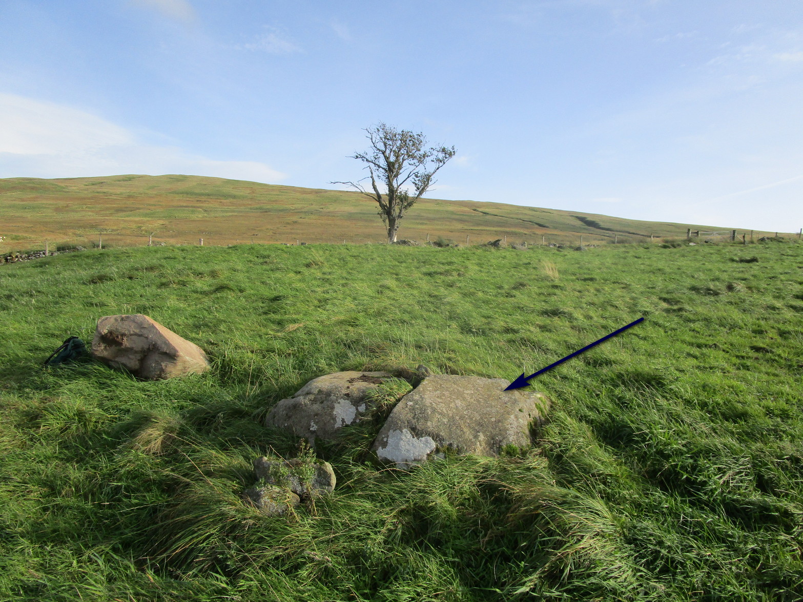
When you’ve visited the impressive cup-marked stone at Dalnavaid, this long lost carving might be worth seeking out by the real explorers among you. It’s not been seen for a hundred years and was only reported in brief by the reputable local historian Hugh Mitchell (1923). It’s located a mile north of the Dalnavaid carving, up in the hills on the other side of the road, “on the East side of Clunskea Burn, and on the West shoulder of Ben Skievie.” He described the carving as “having some 16 or 18 cups, and at present it forms part of a grouse butt.”
So if we locate the grouse-butt (they’re usually not too difficult to find), the carving will obviously follow. Mitchell gave us an extra piece of info regarding its location. He described the existence of several other seemingly prehistoric remains within a few yards of the grouse-butt, curious “pit dwellings”, three of them:
“they are of circular shape, about 9 feet in diameter and nearly 5 feet below the surface of the ground, and had evidently been roofed over at one time. The entrance to each is at the lowest level and acts as a drain, to keep the house dry. They are almost the only examples in the district of neolithic dwellings.”
Let us know if you find it!
References:
Mitchell, Hugh, Pitlochry District: Its Topography, Archaeology and History, L. Mackay: Pitlochry 1923.
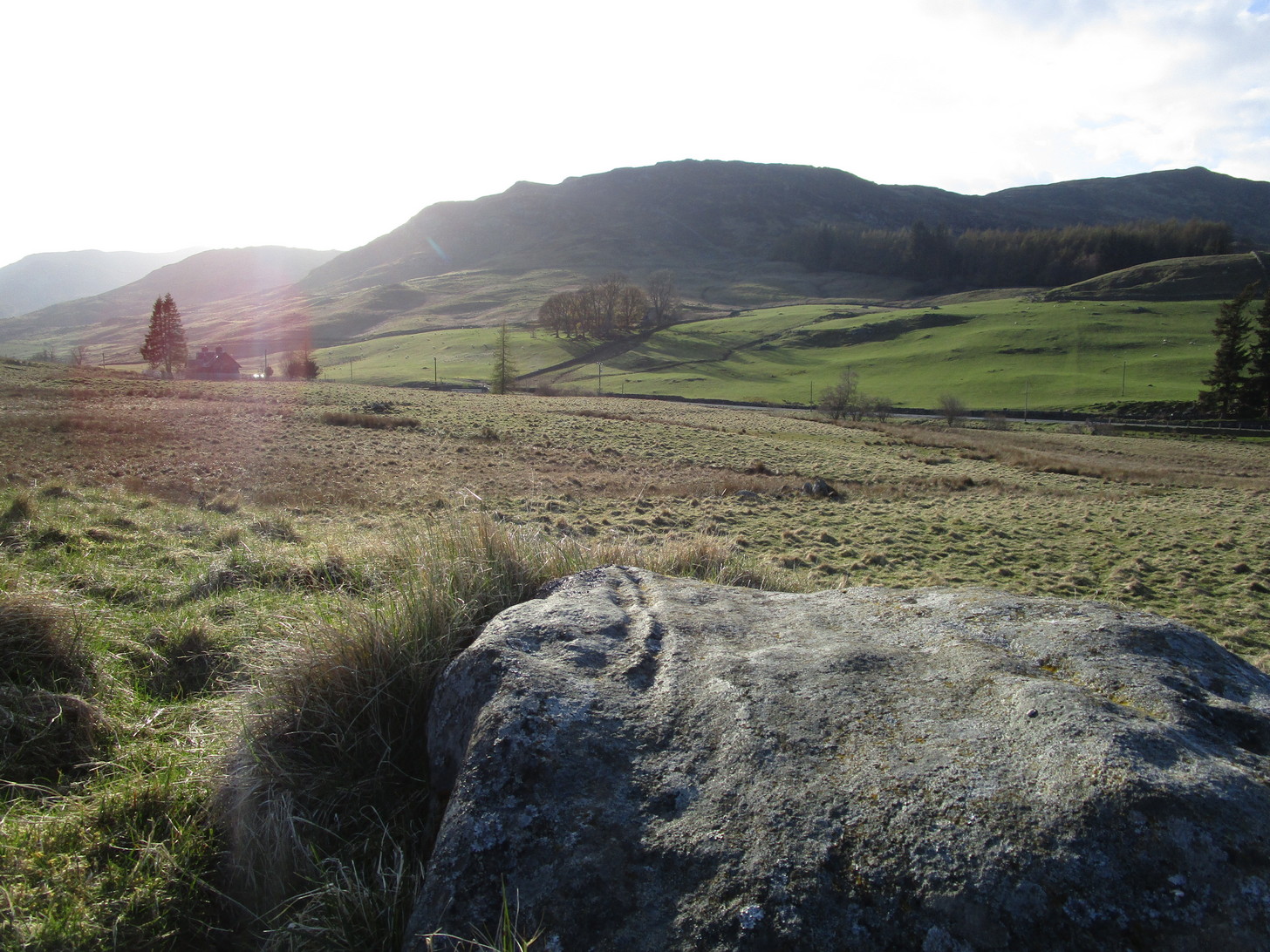
The quickest and easiest route is to take the A924 road from Pitlochry to Kirkmichael. It’s a gorgeous route in itself! Anyhoo… Once you’re out past the houses of Pitlochry and Moulin, you begin to make the real ascent up the winding road, past the hairpin bend and, 5 miles up where the road has levelled out and the craggy moorlands surround you, green fields begin to appear on your left. The first farm on your left is Dalnacarn and less than a half-mile past here, on your right, a small track takes you to Dalnavaid house. Walk along here, past the house and into the field, then the next field where a section rises up towards the fencing. On top of this are several rocks. You can’t really miss it!
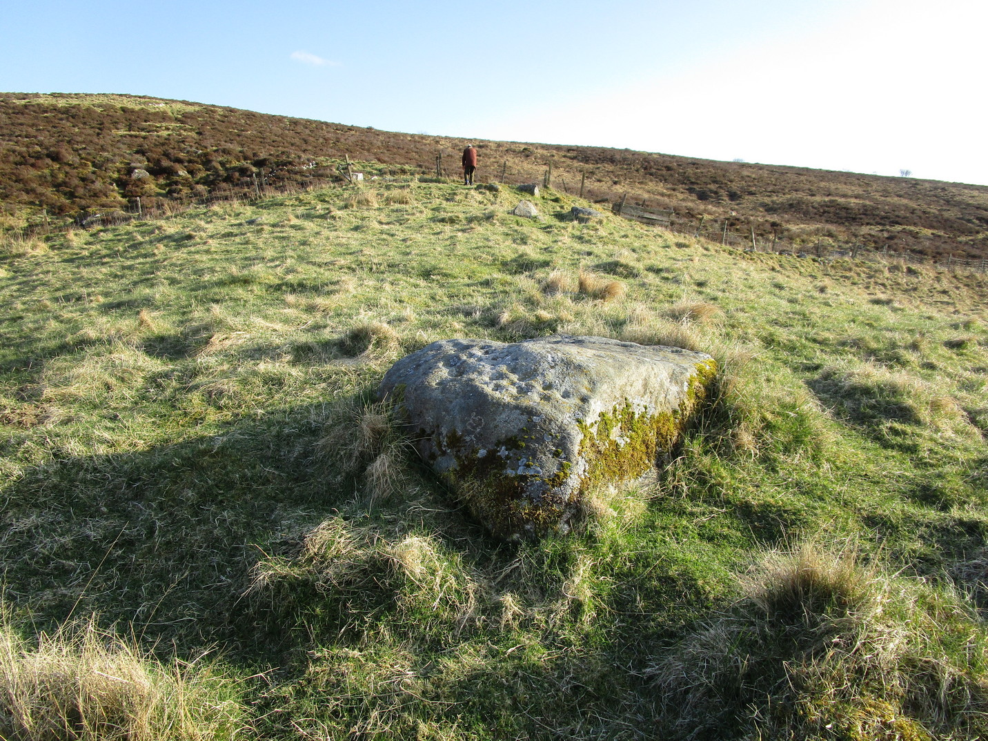
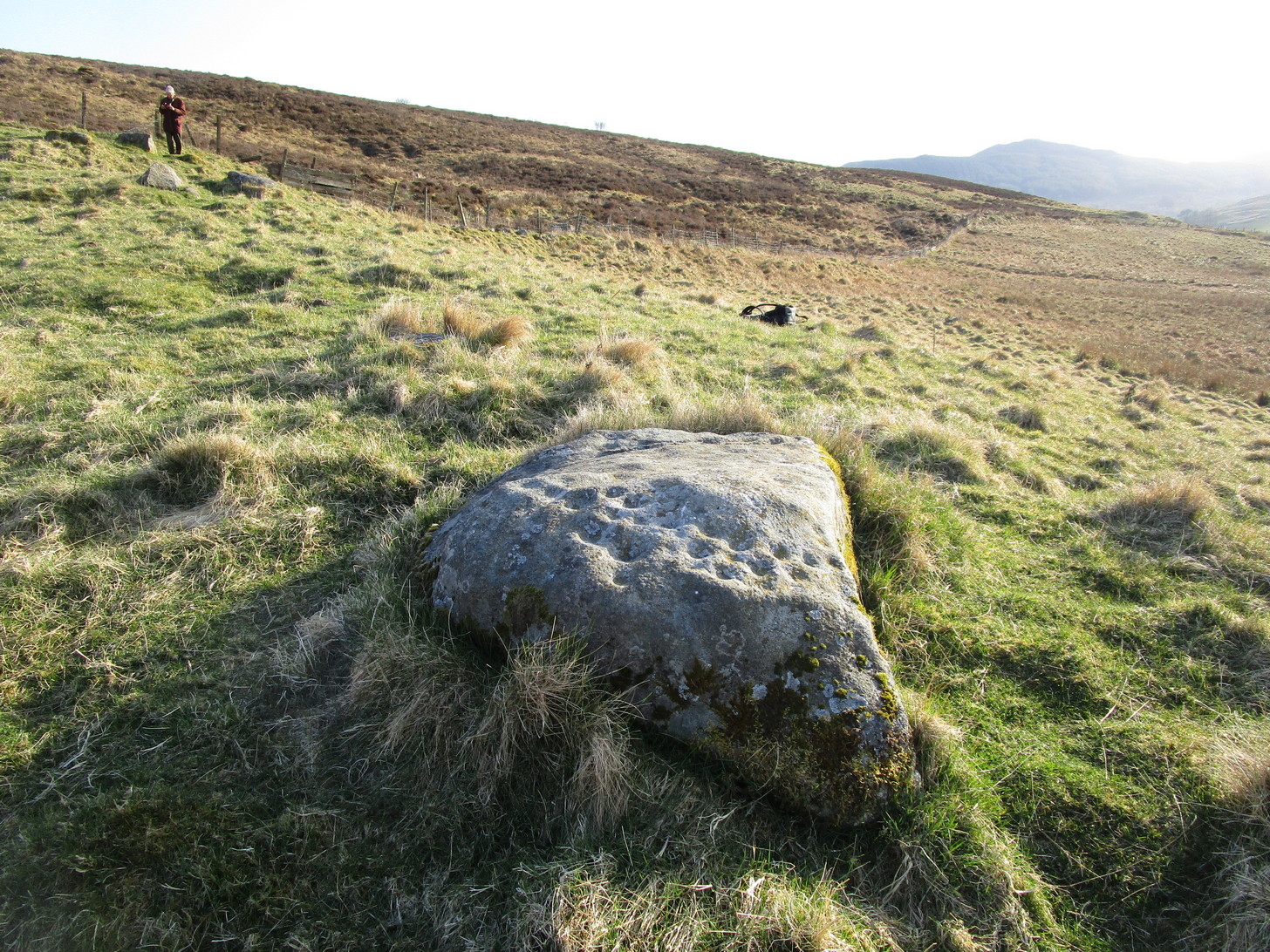
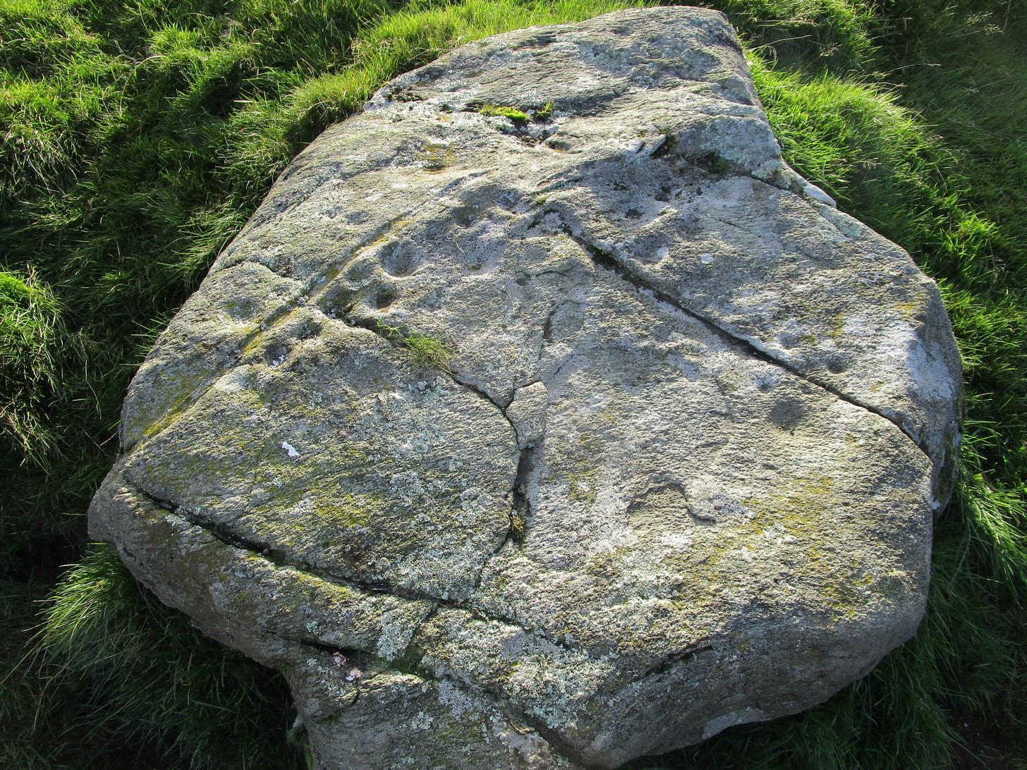
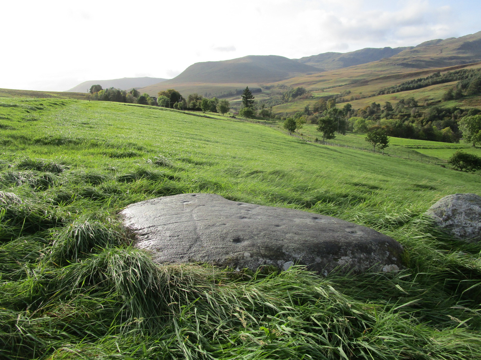
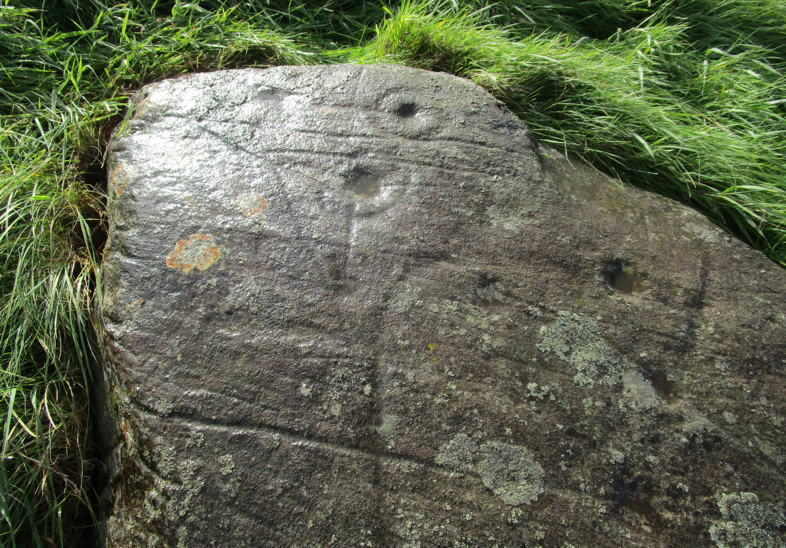
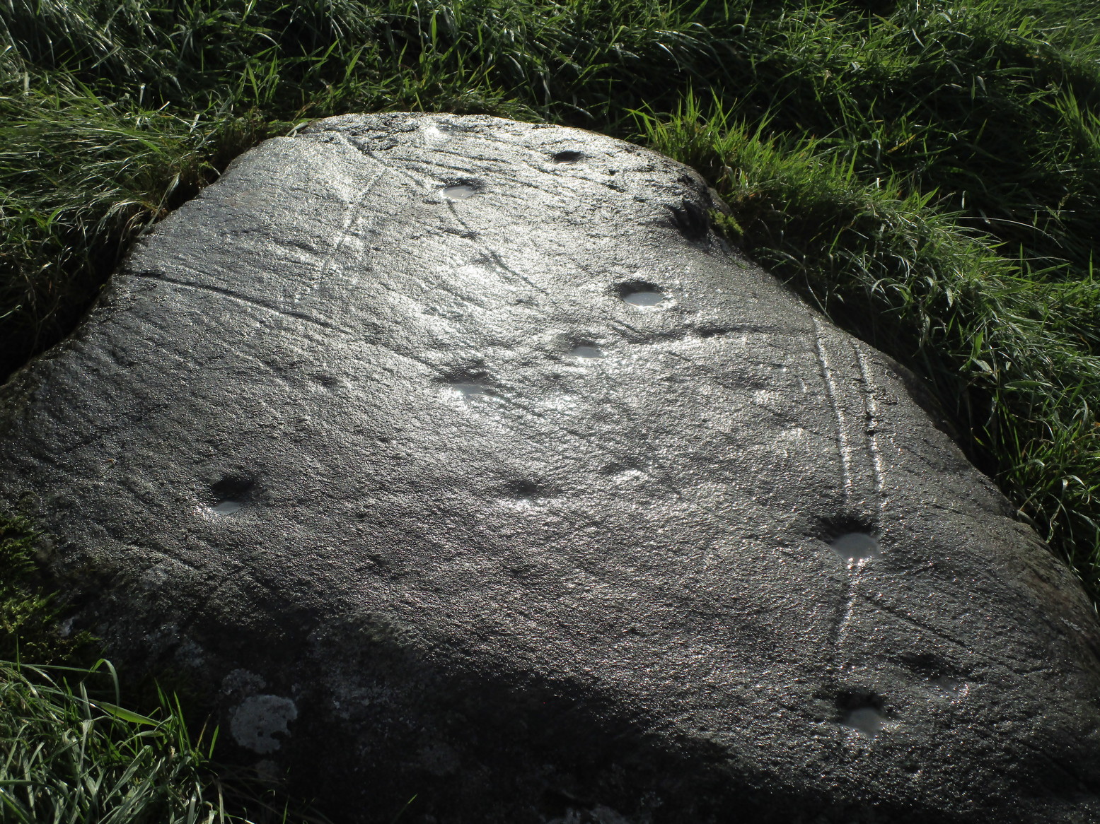
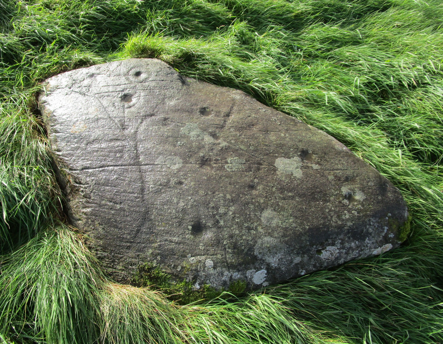
Archaeology & History
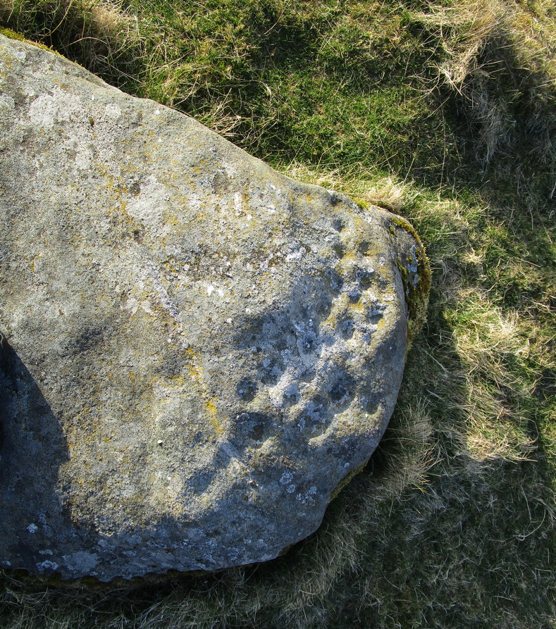
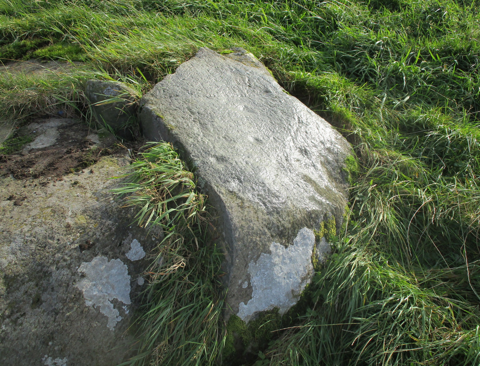
This typically female rounded rock has, unusually, a series of cups in almost three rows along its easternmost slope, with one or two single cups on its top and southern side. It was first described by Fred Cole (1908) merely as “a small boulder, with a remarkable triple row of cup-marks, resting on a cairn-like mound”; but it wasn’t until John Dixon (1921) came here that a full description appeared. He told us,
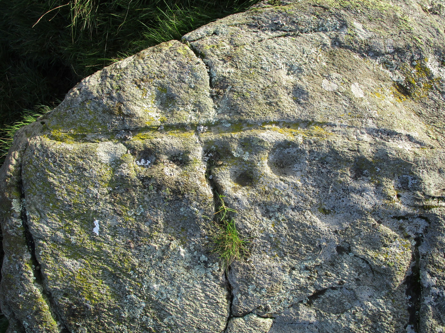
Primary rows of cupsLong worked (?) line
“About 200 yards due east of (Dalnavaid) house a ridge or spit of land juts out from the adjoining hillside on to an almost level field. The ridge has sloping sides, and the nearly flat top is 10 or 12 feet above the general surface of the field. Near the end of the ridge stands the cup-marked stone… The dimensions of the stone are: length 4 feet 8 inches; width 3 feet; height from 1 foot 11 inches to 2 feet 4 inches. The cups are all near the north-east side of the upper surface of the stone, and are more or less in rows. Some are large, with a diameter of 3 inches and a depth of nearly 1 inch; others are much weathered, and vary from small, scarcely measurable, hollows, to cups 2 inches in diameter and ½ inch deep. The hollows are no doubt cups almost obliterated by ages of weathering. Reckoning them so, there are in all thirty or thirty-one cups. All are of the plain type, without rings or connecting grooves.”
Looking (roughly) west
A few years later Mitchell (1923) counted 26 cups on it. Along the western side of the stone are two natural cracks that run across it roughly north-south. It wasn’t until I crouched down to look at what seemed to be another cup on its vertical face that I noticed how these lines appeared to have been enhanced by human hands.
For petroglyph enthusiasts, this is a decent carving well worth the visit. What looks to be a cup-and-ring design is found on a stone due south of here and, in all probability, others are hiding away nearby—the “lost” cup-marked stone of the Clunskea Burn, a mile north of here, being one such place. Let us know if y’ find it!
Make a day out of this one, visiting several old places on the way. From Comrie take the B827 road to Braco, turning right at the tiny Glen Artney road a half-mile along (easy to miss). 3 miles along, pass the derelict Dalness cottage, you can follow the directions to get to the Mailer Fuar (2) cup-and-ring stone; and from here go up the field past the Mailer Fuar (1) carving, through the gate and follow the fence to your right. Keep going till your reach the Allt na Drochaide cup-and-ring stone. From here you’re heading (south) towards the rounded crags of Cnoc Brannan. It’s boggy as fuck in parts so cautiously zigzag through this section up towards the small grassy rise about 350 yards from the cup-and-ring stone. You’ll find it!
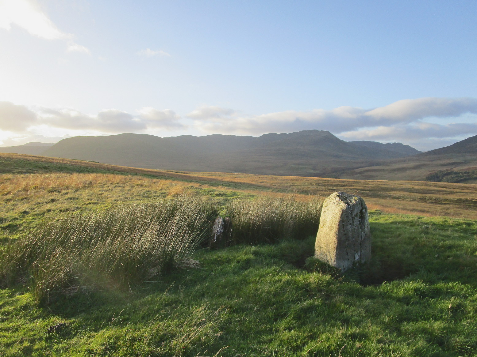
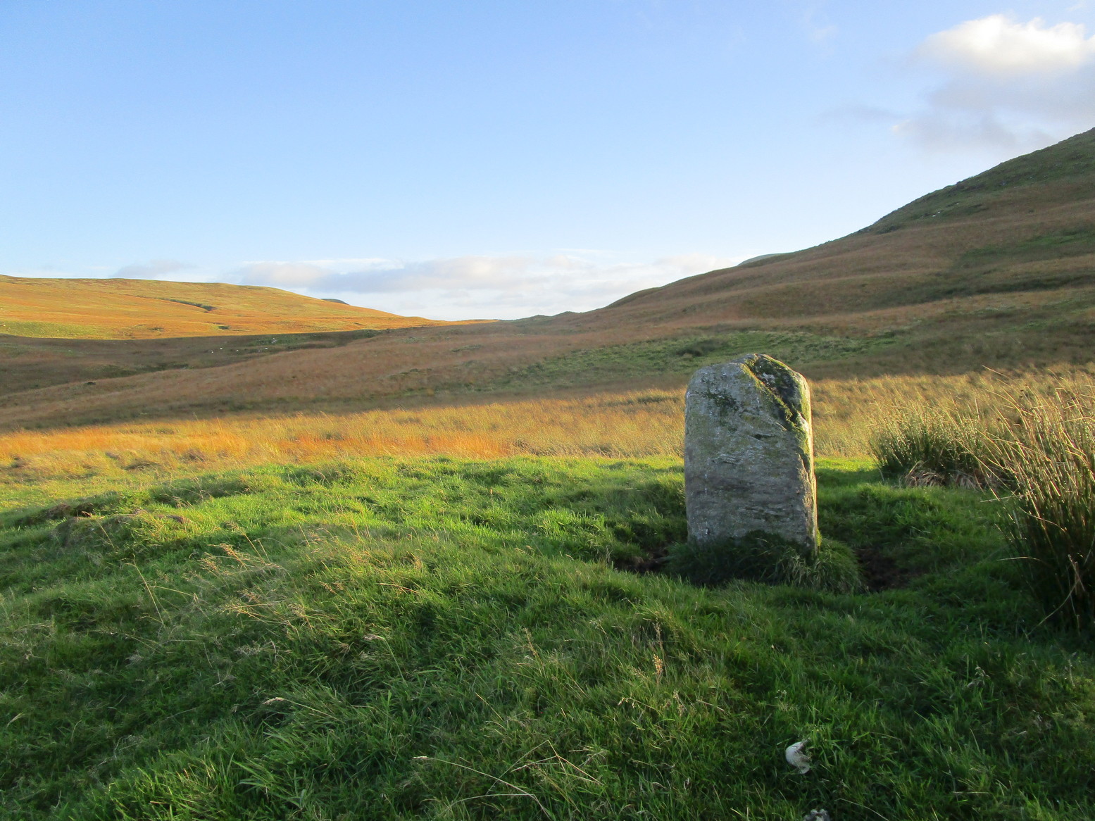
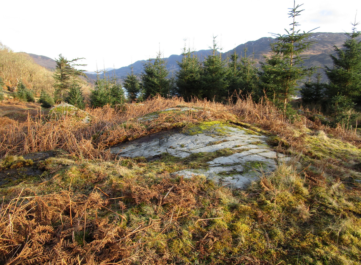
Archaeology & History
From the old stone, gazing S
On one of the gentle rises below the northern slope of Cnoc Brannan we find this sturdy old fella, 3-4 feet tall (I didn’t measure it), looking across the stunning landscapes north, east and west along Glen Artney. Not previously recorded and seemingly isolated from other prehistoric remains, he looks all alone at first sight, but laid down in the grassy rushes (Juncus conglomeratus) to his side, is a slender seven-foot long stone which may have stood upright in the not-too-distant past, giving us another double stone setting in this area (at least two others existed in this area—the closest being at Craggish, 3.7 miles northeast). I have little doubt that other undiscovered prehistoric remains are hiding in the area. (there are a number of single cup-marked stones in the locale, although I tend to leave such examples off the catalogues as they can be somewhat dubious [and many are]. I mention this just in case any rock art students want to forage the area.)
From Comrie take the B827 road to Braco, passing the large Roman Stone monolith, turning right at the tiny Glen Artney road a half-mile along (easy to miss). 3 miles on, pass the derelict Dalness cottage, you can follow the directions to get to the Mailer Fuar (2) cup-and-ring stone; and from here go up the field past the Mailer Fuar (1) carving, through the gate and follow the fence to your right, then drop down into the great boggy reeds, over the burn and up as if you’re heading to the rounded hill of Cnoc Brannan. On a grassy knoll a hundred yards or so up the slope, you’ll see a rock or two. It’s thereby!
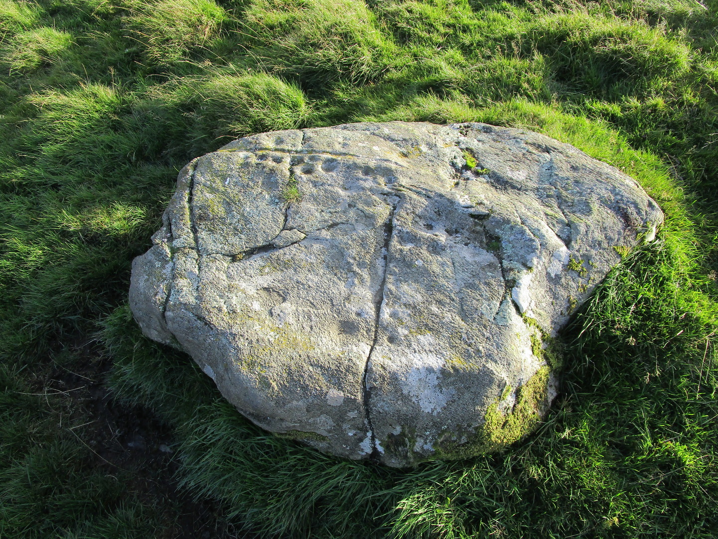
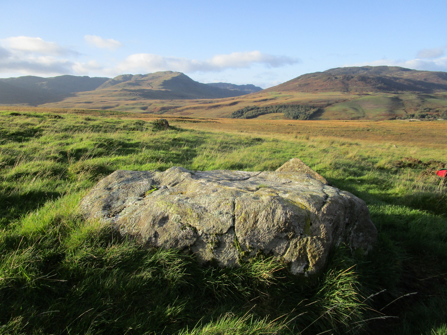
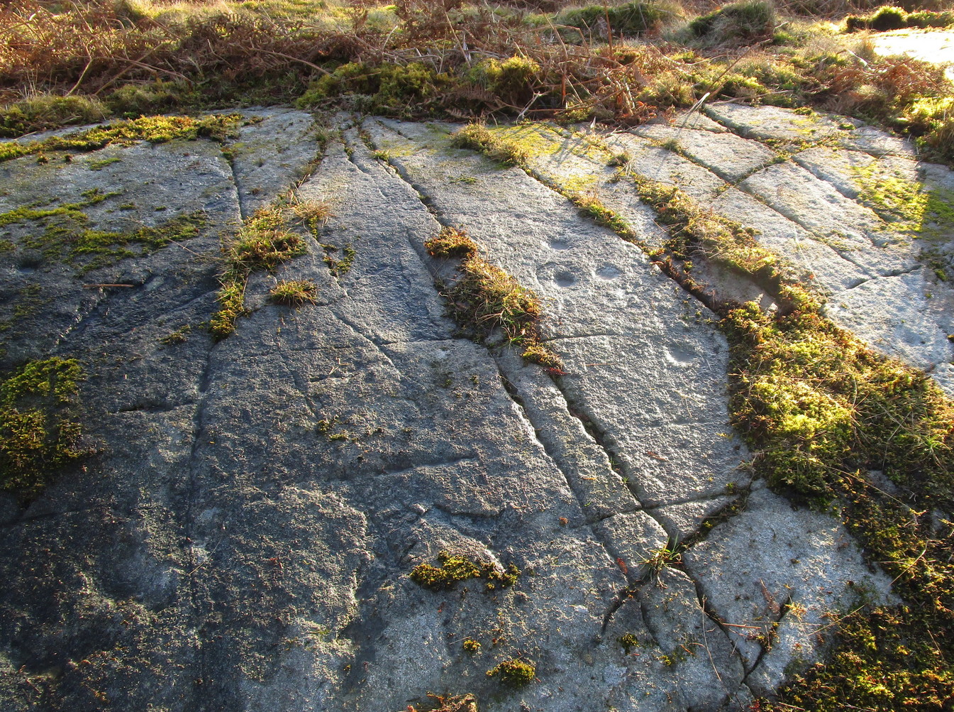
Archaeology & History
The stone in its setting
I came across this petroglyph not too long ago on the same day I found the Cnoc Brannan standing stone a little further up the slope from here. Covered in cup-markings over all except the northeastern portion of its surface, a faint ring seems to be around one of them on its northern side. Of the twenty-two cups on the stone, the majority of them, as the photos show, are clustered alongside a curved natural scar that runs across the topmost section of the rock. There are less pronounced faded cups on the more northern and western portions of the rock, with what looks like one on its near-vertical southern face. Despite its lack of complexity, it has an impressive feel to it.
Main cluster of cups
The home of this carving in its natural setting is what stands out when you’re up here and is certainly what gives it that vibe! The wooded greenery of Glen Artney stretches ahead of you to the east and west, with the craggish mountains of Beinn Dearg, Halton and their compatriots drawing you to the northern side. Tis a gorgeous arena indeed! So, if you’re going to visit its near neighbors at Mailer Fuar a half-mile below, stick this one on your itinerary and, if you’re the roving type, get your feet wet and look around for some more of them. There’ll be others, as yet unknown, hiding away nearby…
From Comrie take the B827 road to Braco and less than a mile out of town take the tiny Glen Artney road on your right. Past the derelict Dalness cottage 3 miles on, a half-mile further, there’s a gated road veering downhill on your right. Park in the small parking-spot at the left. Walk along 100 yards to the gate on your left and walk up the old path which bends back on itself before leveling out. As it does so, just where the Mailer Fuar (2) carving lives, head uphill to the derelict house and, before reaching the fence, check out the several isolated stones on your right. You’ll find it!
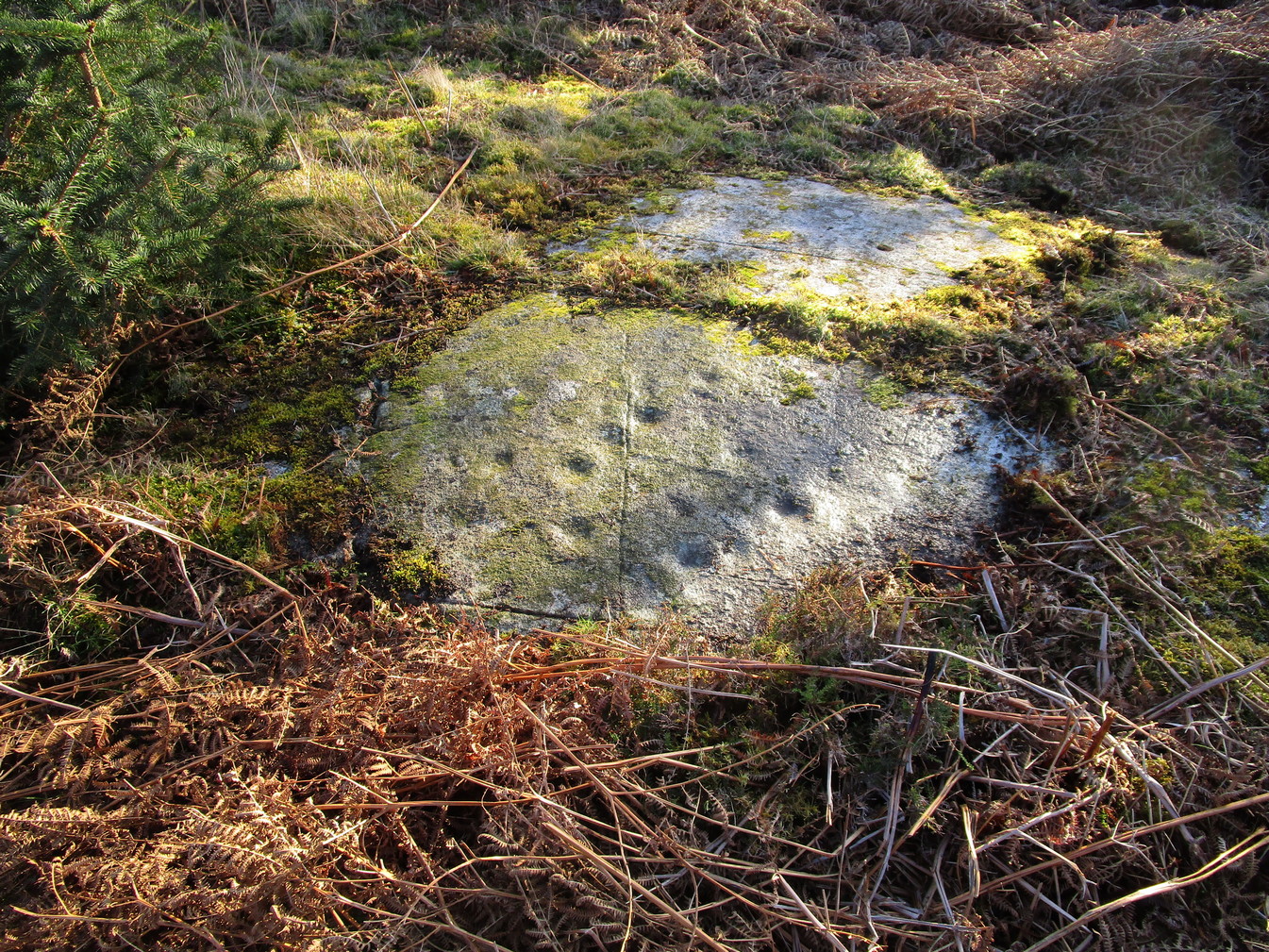
Archaeology & History
Several faint cupmarks
This is nowt special to look at and, as I always tend to say with carvings such as this, it’s probably only gonna be of interest to the petroglyphic puritans amongst you. It was described by George Currie (2006) as possessing just one cup-mark, but there are in fact at least three of them on this sloping rock face, possibly four. One of them may—may—have a half-ring around it, but this is very hard to see and might be little more than a trick of the light and just a forlorn hope of something better… It’s worth a brief look before you venture further uphill to the much more impressive Allt na Drochaide carving.
From Comrie take the B827 road to Braco and less than a mile out of town keep your eyes peeled for the tiny Glen Artney road on your right. Past the derelict Dalness cottage 3 miles on, a half-mile further, just where you hit a track-road veering downhill on your right, you need to park up in the small parking-spot on your left. Walk along the road 100 yards, keeping your eyes peeled again for the gate set back on your left (easy to miss!); go thru here, walk up the old path which bends back on itself before leveling out and, as it does, two or three small boulders lie just off the pathway on your right, one with its own petroglyph.
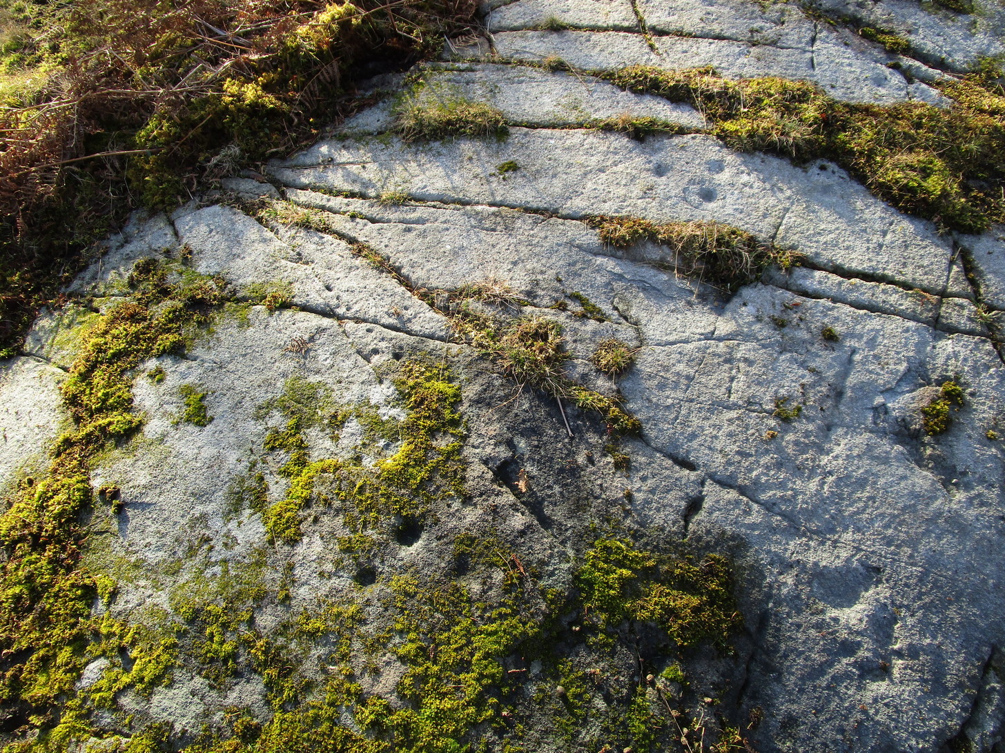
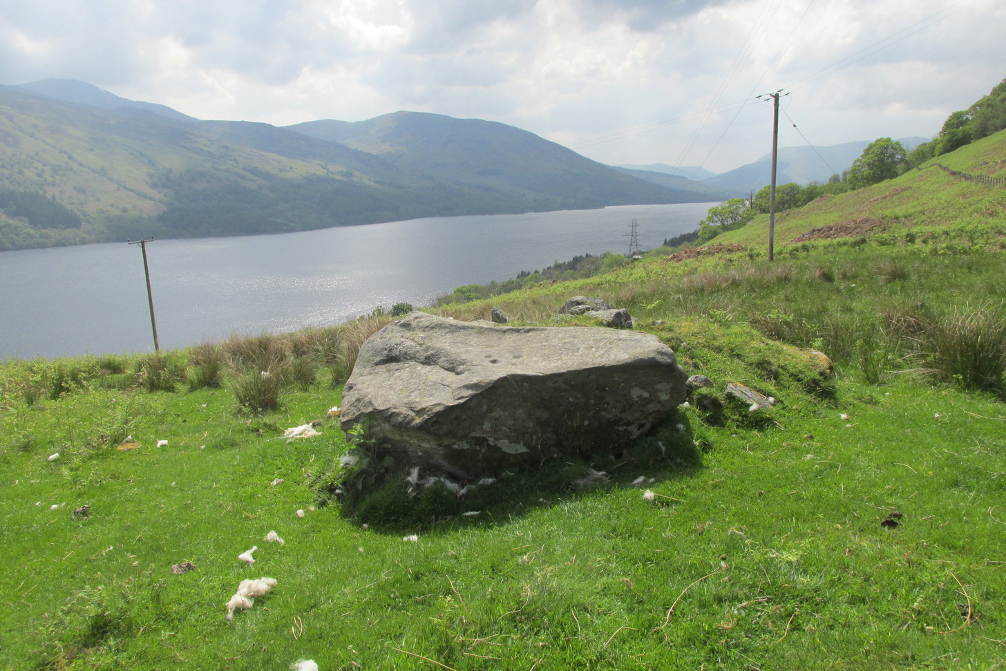
Archaeology & History
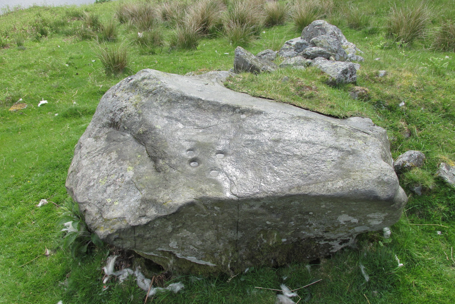
There are cups, rings and lines on this old stone, with the lines in particular being somewhat troublesome when it comes to working out their origin: some are natural, some made by modern farming implements (about a hundred years back), and some that were carved thousands of years ago—and it’s not that easy to work out which is which. You’ll be able to see what I mean by looking at the photos.
Rediscovered, it would seem, by M.D. King in 1991, he described it plainly as a simple
“recumbent cup-marked stone 1900mm by 1200mm by 300mm…found in a stone dyke running down the hill from the deserted farm of Mailer Fuar. The stone may have been moved down from its original position for inclusion in the now ruinous stone dyke. Fourteen cup-marks were visible on the stone.”
Complete cup-and-ringsCnRs and various lines
But there’s much more to it than that! There are rings around the cups for starters. Four of them. Two cup-and-rings next to each other at the southeast portion of the stone are just about complete, as you can see (right); the various lines that run either side and into them seem to be a mix of early and more recent scratches—although I think we’re best asking a petromorphologist to tell us which is which! We have a similar problem for another cup-and-ring near the centre of the stone, for it has two lines going right through its centre: one of them running almost the full north-south length of the stone giving the impression it was carved a long time back, yet looking much less ancient when it comes to its form and erosion; whilst the other line—almost at right-angles to the first—has a decidedly more archaic worn appearance.
General design in low lightLong line, curving at top
One of the more assured “ancient” carved lines is on the eastern section of the stone. (left) It’s an odd looking thing, not very clear on the photo, comprising an elongated curved line, with a fork at the bottom, almost like short legs on an elongated stick-man like the ones we drew as kids. The long line seems to eventually curve over and into one of the cup-marks. Adjacent to the bottom of this forked curve is a cup and faint incomplete ring with a faint line running out of its centre to a smaller faint cup to its west. You can see this reasonably well in the lower photo (right)
The carving needs a lot of attention if we’re to work out its original design, as the photos show. Even the millionaire computer-tech work of the Scottish rock art club didn’t really suss out the differences regarding chronological elements in this carving (I don’t think they even mentioned it), which shows how difficult some of these buggers can be! Personally, I’d love to see the impression of some good artists at this stone when the light’s just right and see what their mind’s eye brings to the fore.
After all this I’ve not even mentioned its position in the landscape. Go check it out and see for y’selves. It’s a bittova beauty! And then wander a little further uphill to look at the Allt na Drochaide (1) carving I found not long ago. The view’s even better from there!
On the A85 road from St Fillans to Lochearnhead, about 1½ miles on is the Loch Earn Sailing Club, with a large parking spot thereby. From here, cross the road and go through the gate up the dirt-track, past the cottages where the track bends right until a few hundred yards further up where the track splits, bear right, along and down across the river, up the other side and past the cottage. From here, the track becomes a grassy footpath. Walk along here, east towards the trees 5-600 yards away. Once you go through the large wooden slip-gate, about 150 yards on the path into the scattered trees, you’ll see a large dome-shaped rise on your right (south). Y’ can’t really miss it!
Archaeology & History
This carving was rediscovered by the great Scottish petroglyph writer Ron Morris in 1968. He told that, just below the overgrown track, “is a big dome-shaped outcrop with a smooth top. On a scattered area on this, in 3 main groups, are over 24 cup-marks, up to 3″ diameter, ½” deep.” But these aren’t mere cup-marks…
Faint, albeit clear cup-and-ringsCup-marks, top & bottom of photo
It literally is just like a large dome of rock, with carvings on certain sections of it. Half of the cup-marks are easy to see, especially the ones near to the top of the dome and which exist in three main clusters. Much more faint is another, larger cluster of cups, on its south-side.
Dealing with those on top of the rock: on the easternmost side a long natural crack separates a faint single cup-mark from a notable triangle of three, clearly visible in the photo (left). Below this are what may be a couple more cups, but they were difficult to make out and may simply be Nature’s handiwork. Certainly Nature has a part to play in the next small cluster of cups about six-feet further along the stone. A shallow natural ‘arc’ has clearly been used to create a ring around one of the cups, clearly visible in the photo (right), with another faint cup-and-ring visible below it. In between these, both Paul Hornby and I could make out what may be another incredibly faint smaller cup-and-ring (and which seemed evident on a couple of photos), but we need to wait for the computer-tech boys to get their teeth into that one! Several other single cup-marks exist either side of another moss-covered crack in the rock. And as we roll over the top western-edge of the stone, another small cluster of three, maybe four single cup-marks greets our attention.
Close-up of southern C&RsSouthern carved section
It’s on the sloping south-side of the stone where the best cluster is found. At least ten faint cup-marks—one or two with very faint incomplete rings round them—are arranged in gentle arcs into the rock. On both sides of this section is a covering of vegetation, beneath which the carved designs probably continue. In fact if this entire stone dome was completely free of vegetation, it’s likely we’d have a much larger piece of prehistoric rock art. A job for future antiquarians perhaps…
References:
Morris, Ronald W.B., “Glentarken Wood, Strathyre – Cup-marked Rocks,” in Discovery & Excavation Scotland, 1969.
Acknowledgments: Big thanks to Paul Hornby for use of his photographs. Cheers dood. 😉
Follow the same directions as if you’re visiting the Wester Glentarken (1) carving, but some 10-15 yards before reaching it, you’ll notice this smaller rock with a series of curious naturally-eroded features on it.
Archaeology & History
This rounded stone has a series of natural deep cracks and undulating geological features on its surface, some of which look like elongated man-made cup-marks—but they’re not! The only man-made ingredient on this stone is the deep single cup-mark close to the centre of the stone, as you can see in the photo. That’s it—nowt else!
1½ miles out of St Fillans on the A85 road to Lochearnhead you’ll reach the boating marina by the lochside. A hundred yards or so past this, park up. Cross the road and walk 50 yards to your right then follow the dirt-track up into the trees. After ⅓-Mile (0.5km) turn left to the old house on your left and follow the green path around it, then around the right-side of the rocky knoll in front of you. Once you’re on the level ground around the knoll, walk forward for less than 100 yards. Y’ can’t really miss it!
Archaeology & History
4 of the 5 main cups
A simple design, but a clear one, of four deep cup-marks which can be seen on the eastern side of the stone, with a solitary one—much more faint—just over the rise on the more western section of the rock.
There are a number of other large sections of rock around the knoll with what appear to be cup-markings of various forms, but apart from perhaps one or two exceptions, the vast majority of them—as Currie (2005) also noted—seem to be natural.
References:
Currie, George, “Wester Glentarken, Perth and Kinross (Comrie parish), cup-marked rocks,” in Discovery & Excavation Scotland, vol. 6, 2005.
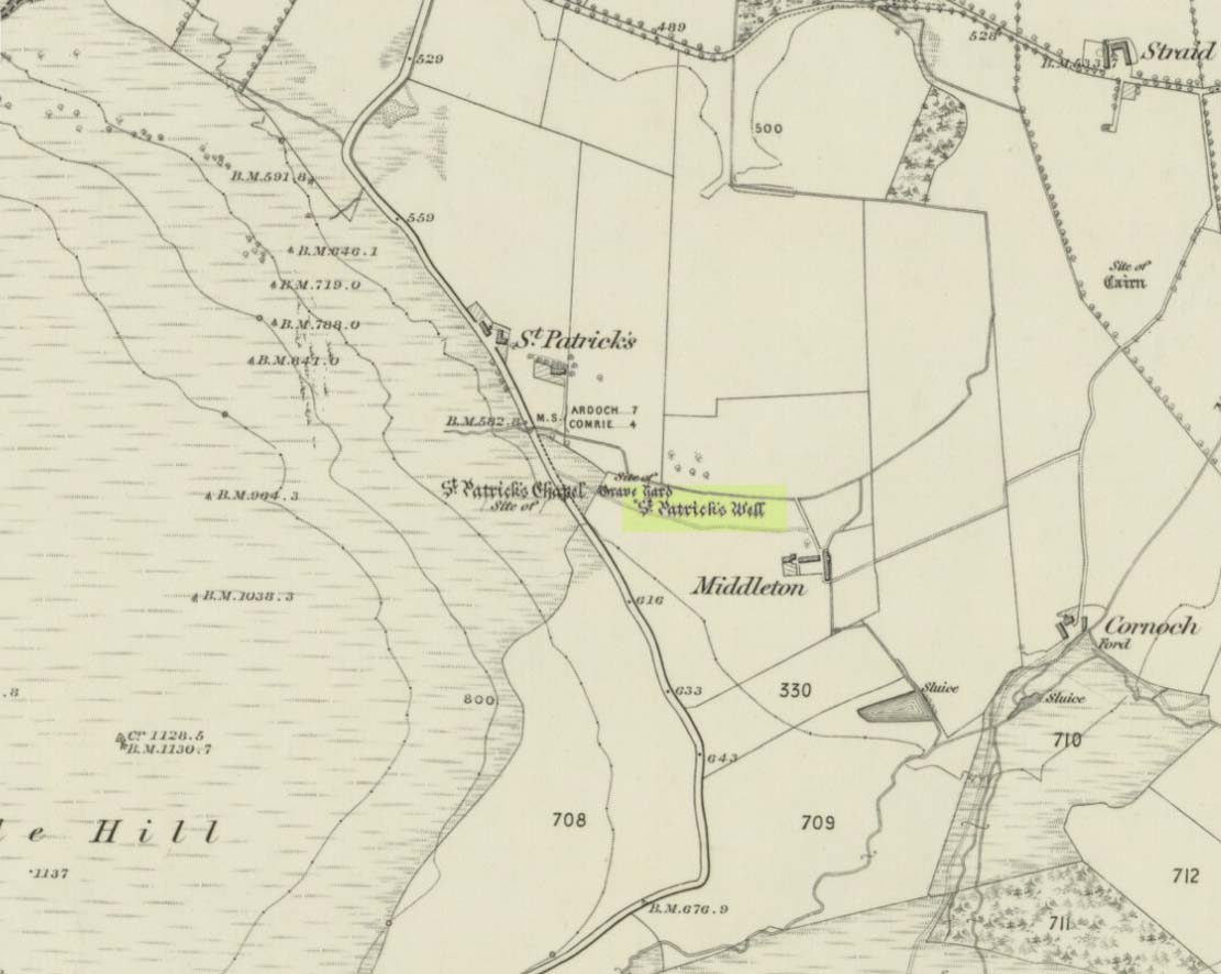
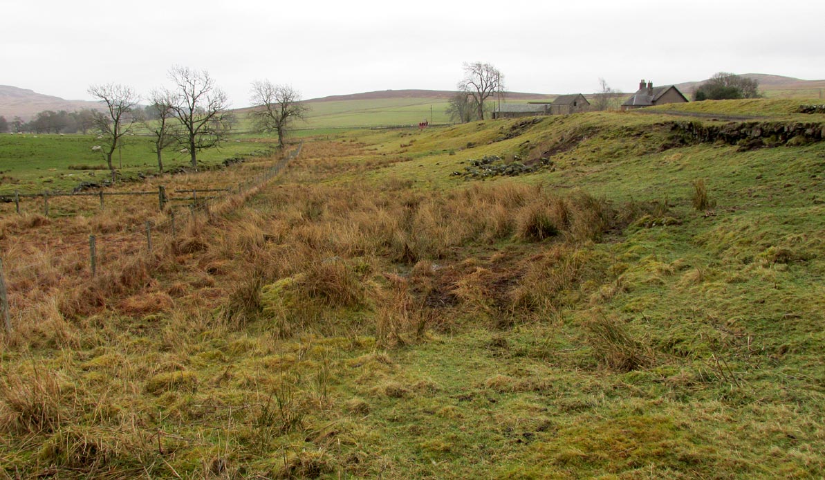
Take the B827 road between Comrie and Braco. If you’re coming via Comrie, going uphill for 3.1 miles (5.1km); but if from Braco Roman Camp go along and eventually downhill for 6.6 miles (10.6km), watching out for the track to Middleton Farm by the roadside. Walk along for 125 yards, keeping your eyes peeled for the boggy ground below on your left. You’re there!
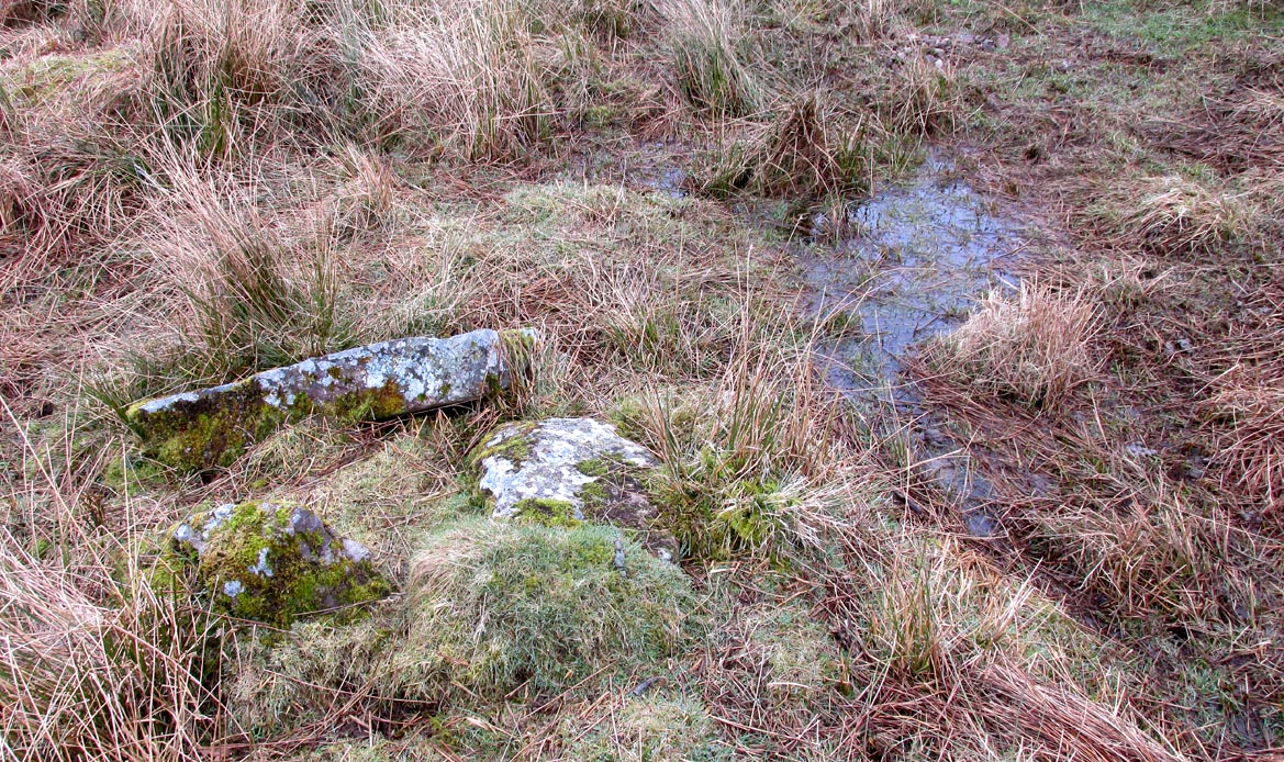
Archaeology & History
Immediately east of the prodigious megalithic complex of Dunruchan, bubbling up amidst the usual Juncusconglomeratus reeds, are the boggy remnants of St. Patrick’s Well—one of two such sacred wells dedicated to the early Irish saint in Muthill parish. We’re at a loss as to why this Irish dood has such sites in his name in this area. No doubt some transitional shamanic character was doing the rounds in this glorious landscape, muttering words of some neo-christian animism, eventually settling a mile from the great megalithic complex, perhaps hoping—and failing—to convert our healthy heathen populace into ways unwise.
The shallow boggy watersThe site of St Patricks Well
Whatever he may have been up to, a small stone chapel was built hereby and, it was said, even a christian graveyard, to tempt folk away from the ancient plain of cairns whence our ancestors had long since buried their dead. But the christian’s chapel and graveyard has long since gone; and when historians before me had visited the place, St Patrick’s Well had also fallen back to Earth in the drier summers, taking the blood of the Earth back into Her body. The heathen megaliths still remain however, standing proud on the moorland plain in clear sight from these once healing waters, whose mythic history, on the whole, has long since been disregarded….
Folklore
St Patrick’s day on March 17—”a date very near the Spring Equinox,” as Mrs Banks (1939) reminded us—may have been the dates when the waters here were deemed particularly efficacious, although we have nothing in written accounts to tell us for sure. But in the 19th century Statistical Account we find that the site was “much frequented once, as effectual in curing the hooping cough.” E.J. Guthrie (1885) told of an ancient rite regarding the drinking of the waters for effect of the cure, saying:
“In the course of this century a family came from Edinburgh, a distance of nearly sixty miles, to have the benefit of the well. The water must be drunk before sunrise or immediately after it sets and that out of a “quick cow’s horn”, or a horn taken from a live cow, and probably dedicated to this saint.”
Also in Muthill parish, Guthrie told, St Patrick’s memory was held in such veneration that farmers and millers did not work on his day.
References:
Banks, M. MacLeod, British Calendar Customs: Scotland – volume 2, Folk-lore Society: Glasgow 1939.
Booth, C. Gordon, “St Patrick’s Well (Muthill Parish),” in Discovery & Excavation, Scotland, New Series volume 1, 2000.
Guthrie, E.J., Old Scottish Customs, Thomas D. Morison: Glasgow 1885.
MacKinlay, James M., Folklore of Scottish Lochs and Springs, William Hodge: Glasgow 1893.