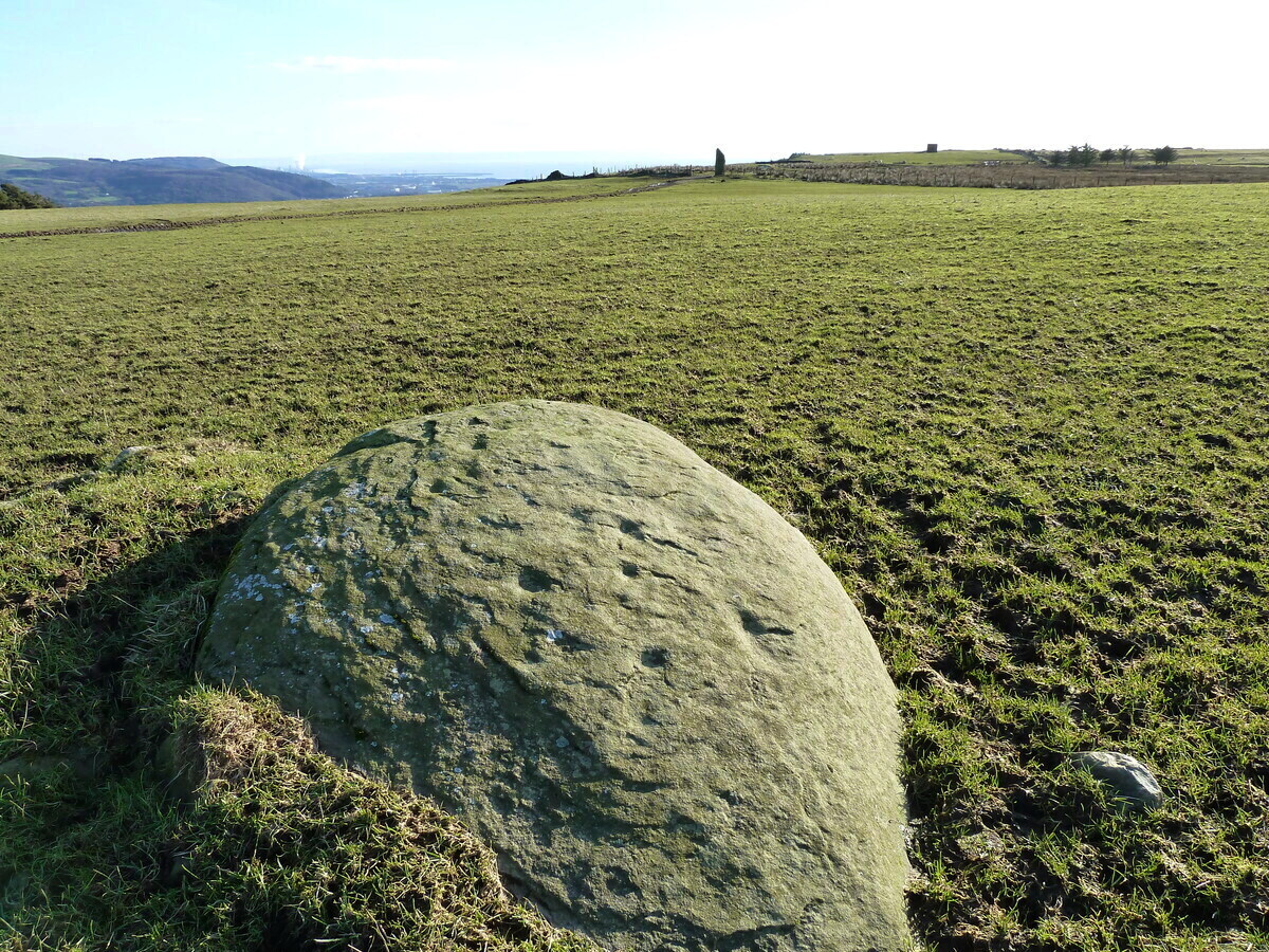
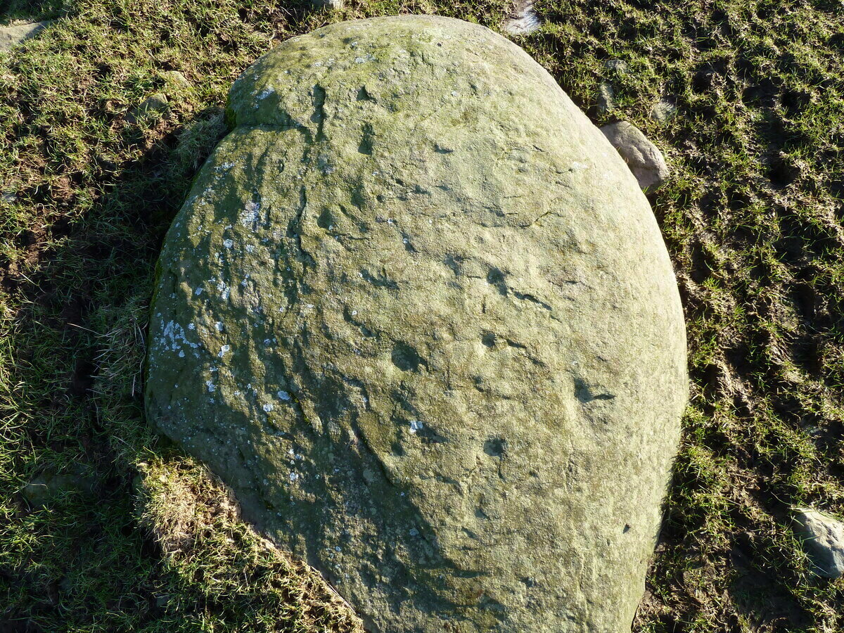
An interesting new cup-marked stone found by Paul Blades is this smooth rounded (female) stone that may originally have had some relationship with the tall standing stone of Careg Bica 160 yards to the south. Around ten cup-marks are etched onto its surface, in a seemingly random arrangement (as usual!). Although it seems to be an isolated carving, it’s likely that others will exist in the area.
Carving & outlying monolithCareg Bica petroglyph
The direction and proximity of the standing stone may have had some relationship with the carving. In traditional northern hemisphere societies, the cardinal direction North is generally associated with darkness and death, primarily due to the fact that this is the area in the heavens where neither sun or moon ever appear; whilst South relates to life and positive natural associations due to it being the high point of the sun during the day. This animistic attribute existed till recently in the water-lore of northern England and Scotland where “south-running streams bore a high repute.” Whilst such mythic attributes are well established, any cardinal relationship here is purely speculative.
Acknowledgements: Huge thanks to Paul Blades for use of his photos in this site profile – and of course for finding the stone!
Follow the directions to reach the Ancestors’ Stone and the Sunrise Stone; and there, roughly halfway between them, right by the edge of the old collapsed walling, you’ll see this rise of a stone with a large ‘bowl’ on top. That’s it!
Archaeology & History
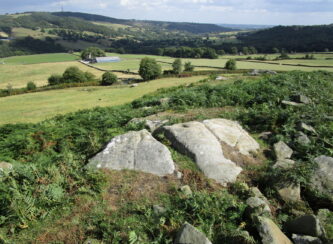
Mixing Stone, looking E
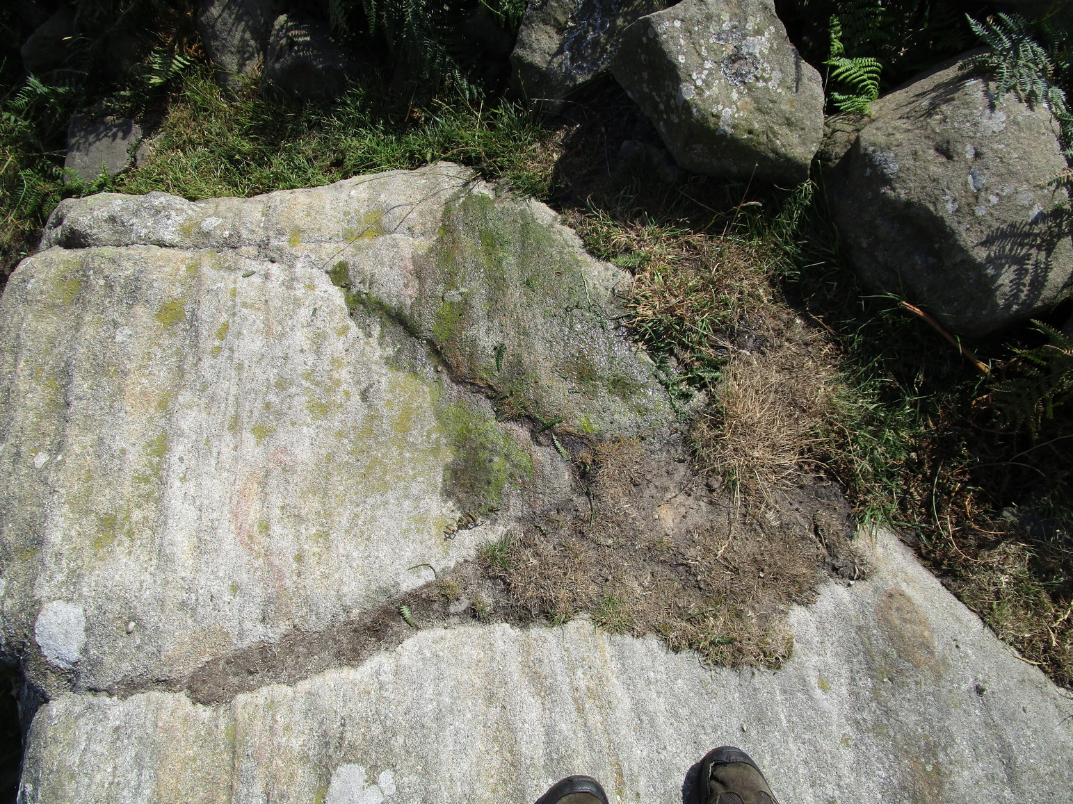
Laid upon the same geological ridge as our Ancestors’ and Sunrise carvings, there are one, possibly two faint cup-marks visible on the low flat surface near the edge of this rock, barely visible unless the light’s right. But the important element here, perhaps regardless of the cup-marks, is the ‘bowl’ or rock basin on top of the stone. Internally, it’s smoothed equally on all sides and, due to being in-between the two impressive petroglyphs, may well have had a practical function to it. Bear with me on this one…
The Mixing Stone’s bowl
Stone ‘bowls’ or cavities—natural and otherwise—have been made use of in many cultures for simple functional purposes, such as grinding flour, herbal mixes, etc. We find such traditions in some of the bullauns of Ireland and Scotland; whereas in similar stone bowls known as cat troughs in nearby Haworth, milk was poured to appease the spirits of the land (this tradition was still being maintained in 2001!). Folklore and traditions of such rock basins spread far and wide beyond the UK: one of the German terms for rock basins is Opferkessel, meaning ‘sacrificial basin’ and suggests ritualistic usage by early societies. Elsewhere on Earth there are numerous accounts of the ritual use of petroglyphs in which indigenous peoples tell of their use of plant- or rock-based paints (in many cases red ochre) to decorate the carvings. And it’s this element that I’m interested in here.
Water-painted cupmarks
The Sunrise and Ancestors’ Stones 10-15 yards either side of this Mixing Stone are ideal candidates for such petroglyphic paintings using early ochre and other stone or plant-based agents. Such activities would always have been ritualised, either in honour of ancestors, genius loci, calendrical rites, or whatever the pertinent ingredient was at that place and time. I’m suggesting simply that the rock basin on the Mixing Stone was used for just such purposes. This is no spurious suggestion, but at the same time it’s important to recognise that my thoughts here represent merely an idea, nothing more—not a fact. Whilst we know full well that these carvings were imbued fundamentally with animistic properties—a simple ‘fact’—this functional idea is just that—an idea. Students and petroglyph-nuts need to understand this. And the faded cup-marks at its edge are perhaps merely incidental…. though I don’t buy that misself!
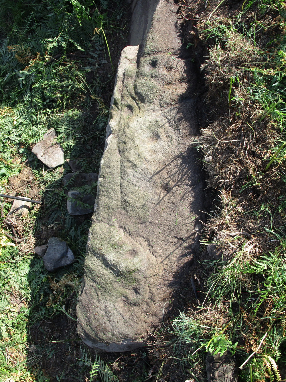
If you’re coming up from Otley or Askwith, take the same directions as if you’re going to visit the impressive Naked Jogger Carving (stone 612), not far from the well-known Tree of Life Stone. From the Naked Jogger carving, walk up to the small outcrop of rocks that bends above you. There’s a small collapsed line of walling just behind the outcrop. Walk along this up the slope as if you’re heading for the Sunrise Stone carving, but only 30 yards along, low down and right into the edge of the wall itself, you’ll see this elongated piece of stone. That’s the spot!
Archaeology & History
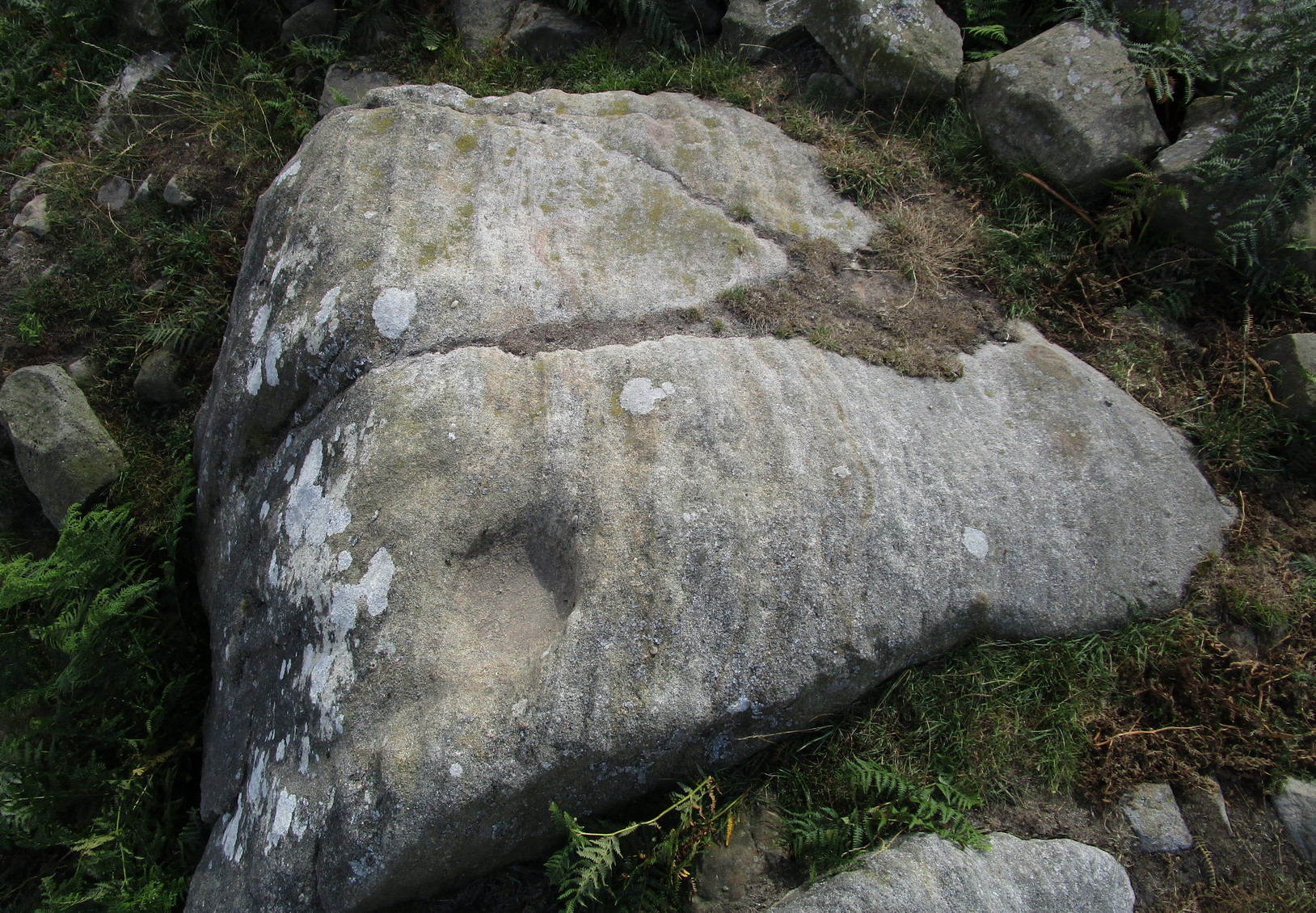
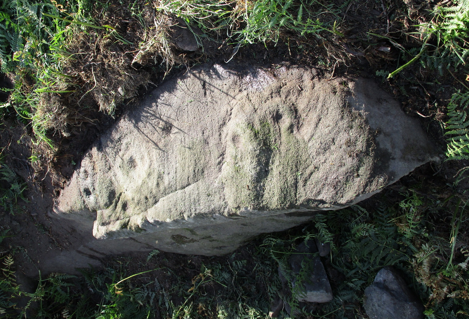
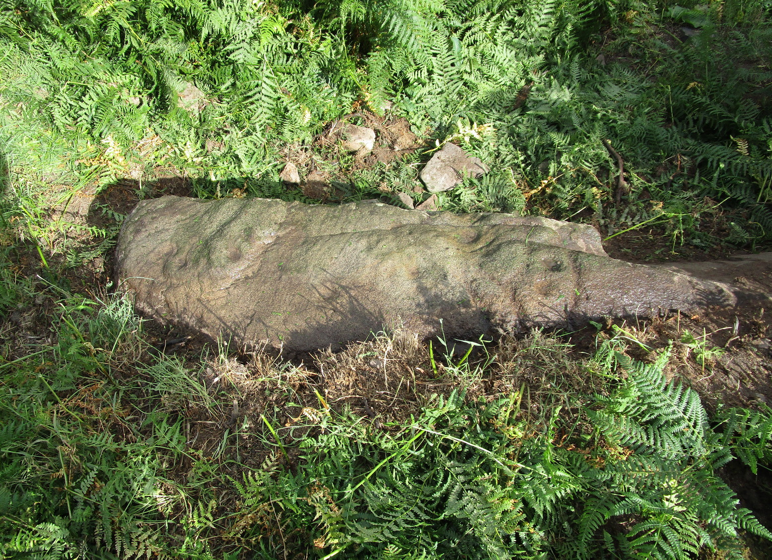
If you’ve caught the petroglyph-bug, you’ll like this one! It received its name from the curious fusion of natural cracks with the man-made pecked lines that shows, quite distinctly when the light is right and the stone is wet, the outline of two humanesque forms joined to each other. Figurative rock engravings of ancestors in the UK are extremely rare and when we came across this example, we noticed how the design could be interpreted as two Askwith Moor ancestor figures. Figurative rock art images elsewhere in the world such as the magnificent Wandjina paintings and the extensive galleries of figures engraved at Murujuga (Burrup Peninsula) in Western Australia, might provide an initial comparison, though more specific work needs to be done to better understand this unique petroglyph.
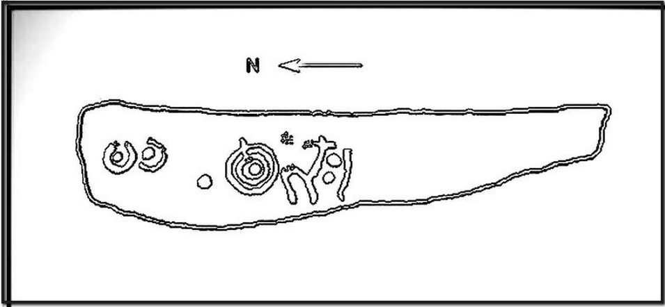
Sketch of the carving
You can almost make out the figures in the above photo: the upper torsos of two beings on the right-hand side of the rock, almost fused together. And the carved shapes of these “ancestral beings” are morphically similar to some elements in the Sunrise Stone just 50 yards away – which themselves remind me of a Northumbrian carving near Doddington known as West Horton 1a. (Beckensall 1991) But we should’t get too carried away by the idea because—as we can see here in the sketch of the carving—when looked at from a different angle above, we could infer the right-hand carved elements to be representative of an animal: a deer, perhaps. Rorscharch’s once more tickle the exploring mind….
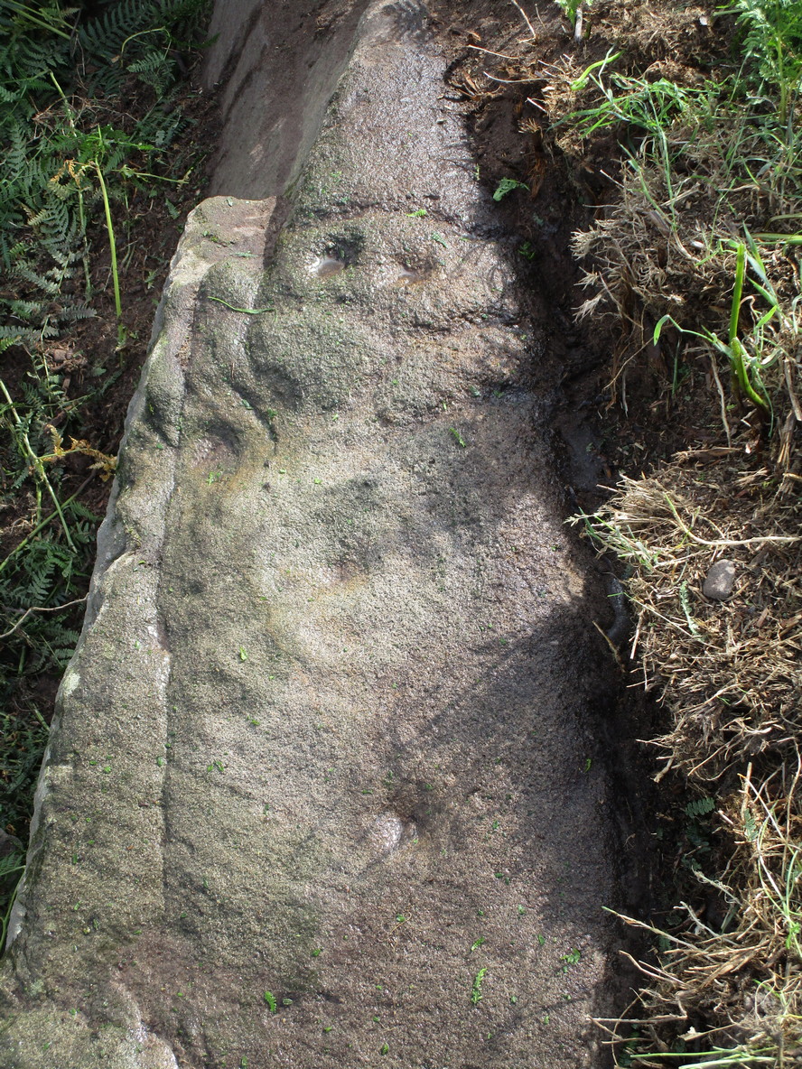
The rock has been quarried into at same time in the past (just like the nearby Sunrise Stone), leaving us to wonder what the complete carving might have looked like. No doubt some pieces of it will be in the collapsed walling either side of the stone. All we have left to see are the two unfinished cup-and-rings above the natural cracks that give rise to the “ancestral being” appearance. The faint double cup-and-ring has curious linear arcs to its side, with two well-defined cups enclosed by two of them. It’s a nice-looking carving when the light is good. The petroglyph was carved over a long period of time, as evidenced by the differing levels of erosion in different sections of the design. It’s a common attribute. The oldest section is the faint double cup-and-ring, whose mythic nature was added to / developed at a much later date, perhaps even centuries later.
In the always-expressive archaeocentric description of Boughey & Vickerman’s (2003) otherwise valuable tome, they told this carving to be,
“Long, narrow, thick rock of medium grit. Six cups, one with a double ring with a tab out and two with at least partial single rings, grooves.”
Evocative stuff!
It’s very likely that this carving had some mythic relationship with its close neighbours either side of it, probably over a very long time period and I’m inclined to think it somehow related to the rising of the sun, just like its solar companion further up the slope. Please note how I emphasize this ingredient in the site profile of its neighbour, the Mixing Stone 10-15 yards away—roughly halfway between this and the Sunrise Stone. A distinct place of ritual was happening in this close-knit cluster of carvings…
References:
Beckensall, Stan, Prehistoric Rock Motifs of Northumberland – volume 1, 1991.
Boughey, Keith & Vickerman, E.A., Prehistoric Rock Art of the West Riding, WYAS: Leeds 2003.
Reeder, Phil, “Snowden Carr Rock Carvings,” in Northern Earth Mysteries, no.40, 1990.
To be found a couple of hundred yards west of Askwith Moor Road, head towards the bottom of the row of grouse-butts, following the fence that runs into the moorland across from the dusty car-park.
Archaeology & History
Single cup-marked stone
This single cup-marked stone — list as carved stone no.529 in Boughey & Vickerman’s (2003) survey — was reported when some English Heritage doods came here and found this small upright stone (probably part of a larger prehistoric monument, e.g., walling or cairn) and gave the cup-marking their “all clear” stamp and thought it authentic. But if memory serves me right (which it doesn’t always do these days!), I’m pretty sure Graeme Chappell came across this possible carving in the early 1990s during one of our many forays over these moors. It’s a cute little thing — though only for the purists amongst you perhaps — but, of course, needs to be seen in the context of its proximity to the many other prehistoric monuments across this moorland plain.
References:
Boughey, Keith & Vickerman, E.A., Prehistoric Rock Art of the West Riding, WYAS: Wakefield 2003.
From Askwith village, at the T-junction, go up Moor Lane, taking the left turn up Moorside Lane about half-a-mile up and on the track to Moorside Farm and then onto Top Moorside Farm. Take the path past the farm up onto the moor, then bear right up the small track that heads up onto the small Hollin Tree Hill. As you go up the track, watch out for the small grassy depression to the right; and hereby head into the grasses on your right. You’re close!
Graeme Chappell was the first to rediscover this carving in the early 1990s when we were up pottering about on these and the adjacent moors, looking for any previously undiscovered prehistoric relics. We found quite a lot! The carving here is nowt special to look at really, but the cups can be seen quite clearly. It’s a rather large stone on the western edge of the hill with at least seven or eight cup-marks carved across its upper surface. Boughey & Vickerman (2003) later described it as “large, fine quartz sandstone rock with surface sloping slightly down into (the) hillside. Seven or eight cups, two particularly sharp.” There’s a possible line running between two of the cups, visible when lighting conditions are right — though we aint sure whether it’s artificial or not.
References:
Boughey, Keith & Vickerman, E.A., Prehistoric Rock Art of the West Riding, WYAS 2003.
To find this, head for the line of old grouse-butts which run north-south, a few hundred yards west of the Askwith Moor Road. Just before y’ get to the one nearest the bottom of the line, frobble about a bit. If by any chance you end up at the Woman Stone carving, walk back up the slope until you’re on the level. Not far ahead of you are the upright stone remains of a grouse-butt. This carving is just a few yards away. You’ll find it.
This was another carving found on one of the many forays of Mr Chappell and I when we were young, sometime in 1993. A short while after, Graeme wrote to Edward Vickerman to inform him of the find, which ended up in their rock art survey a decade later.
It’s another one of those simple designs: what seems like at least 5 cup-markings on a small rounded rock, with two of them linked together by a groove — possibly natural, possibly man-made — though there may in fact be seven or more cups etched onto its upper surface. It’s difficult to tell. It gives you the impression that its present position isn’t its original one and is suggested by Boughey & Vickerman (2003) to have been “moved from pipeline?” close by. It may even have been dug out and cast here, possibly once being a part of a cairn. In the Boughey & Vickerman survey they give its OS-coordinate as SE 17163 50527 – and describe it as a “medium-sized, free-standing rock of fine grit. Five cups, some perhaps natural.” When Richard Stroud and I visited the site, he found the GPS coordinate was SE 17162 50530; and we have to say that instead of describing it as a free-standing rock, it’s a movable stone (though it’d take a bit of effort), that may once have been part of a larger monument.
References:
Bennett, Paul & Chappell, Graeme, Personal Communication, 1993.
Boughey, Keith & Vickerman, E.A., Prehistoric Rock Art of the West Riding, WYAS: Wakefield 2003.