Brotton Howe, Brotton, Cleveland, North Yorkshire

Cairn (destroyed):  OS Grid Reference – NZ 6950 1886

Archaeology & History
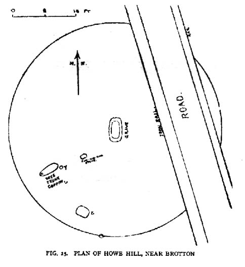
Frank Elgee’s 1930 plan

Another old site that has sadly succumbed to that bollox called ‘progress’! It’s in the North Yorkshire region some halfwits have taken to calling Cleveland — but which a lotta local folk still correctly call Yorkshire.  But that aside…

In an article by local students William Hornsby and Richard Stanton written in 1917, we find that this was just one of at least seven hillocks presumed to be barrows here — but all the others had gone even in their day.  When Crawford (1980) came to survey the site in the late 1970s, he told that,

“this large barrow is now only visible as a low swell in an arable field… (but) the profile of the barrow is retained in the hedgeline that bisects it from north to south, but the whole of its eastern half has been obliteratd by the Brotton-Kilton road.”
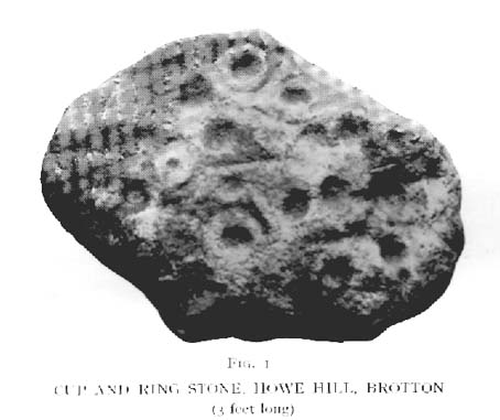
Elgee’s 1930 photo of one of the carvings
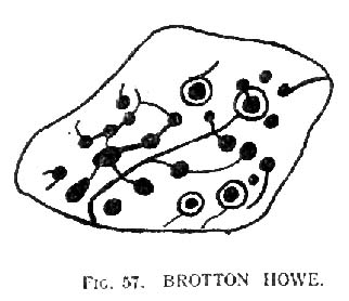
E.T. Cowling’s drawing of one of the carvings

When Hornsby and Stanton checked the place out it measured 54 feet in diameter and had an extensive covering of small stones, like a large cairn, with a single grave at the centre, aligned north-south; and a tree-trunk coffin on the southwestern side.  Of the stones which filled the central grave, eight of them were found to have cup-markings on them; whilst 16 stones covering the tree-trunk grave also possessed cup-markings. Roughly equidistant between the two burials was another stone found to be resting face-down on the original ground-level, and covered with 20 cups and 5 cup-and-rings!  Awesome stuff!

G.M. Crawford’s (1980) description of the site was as follows:

“Howe Hill was excavated by Hornsby and Stanton in 1914; they discovered that the mound was made up with a clay floor, overlain by ‘a cairn 30 feet long and 3 feet high’ of diorite cobbles, capped by a layer of earth. Cut into the clay floor were two graves: the first was oriented north-south and measured 2m long by 0.9m wide at the old land surface and was 0.7m deep. The grave was filled with ‘medium sized stones’ with a ‘thin dark layer,’ thought to be an inhumation burial, on the floor; 8 of the stones bore cup-marks. The second grave, oriented northeast-southwest, was 2.5m long by 0.9m wide at the old ground surface, reducing to 1.8m long by 0.5m wide at its bottom, 1.3m below. This grave, which was filled with stones, also contained a tree-trunk coffin or oak, measuring 1.5m long… At the head (northeast) were found the unburnt skull fragments of a man laid on its right side. Unaccompanied cremations had been placed at both ends of the coffin. 16 cup-marked stones were among the infill of the grave.”

This was obviously a site of considerable importance and it’s a huge pity (if not a disgrace) that today no trace of the site remains.

References:

  1. Cowling, Eric T., Rombald’s Way, William Walker: Otley 1946.
  2. Crawford, G.M., Bronze Age Burial Mounds in Cleveland, Cleveland County Council 1990.
  3. Elgee, Frank, Early Man in North-east Yorkshire, John Bellows: Gloucester 1930.
  4. Hornsby, William & Stanton, Richard, “British Barrows near Brotton,” in Yorkshire Archaeology Journal, 24, 1917.
  5. Smith, A.H., The Place-Names of the North Riding of Yorkshire, Cambridge University Press 1928.

© Paul Bennett, The Northern Antiquarian

Hood Hill Stone, Kilburn, North Yorkshire

Legendary Rock:  OS Grid Reference – SE 503 812

Getting Here

From Kilburn village, take the north road up past the church for about 300 yards, bearing up the track on your left and walk up into the wooded hill a mile ahead of you.  It’s in there!

Folklore

In this region there’s a teeming cluster of druid, fairy, devil and spook-lore, along with numerous prehistoric remains. Not sure this site has such an archaic pedigree, though the creation myth told of this rock (marked on the 1st edition OS-map as an antiquity) seems to imply as such. Our old devil disguised himself as a druid many moons ago in an attempt to gain favour with the old priests, but was discovered in his plans and so, in anger, flew out across the hills carrying a great stone with him which he dropped from the skies and it landed where the Hood Hill Stone still remains. Also in anger he jumped down and stood on the great rock, and in doing so left his footprint impressed upon the stone. (There’s the possibility this is an unrecognised cup-marking – having not been here I can’t say misself).  Edmund Bogg (1906) also tells us that,

“The monk’s hood-like configuration of the crest is said to have originated its name. The busy tongue of tradition, however, says that the name commemorated Robin Hood who, with his merry men, affected the hill-fastnesses hereabouts; but the hill was named ‘Hode’ long, long before the famous Robin came this way at all.”

The same writer also told how,

“legend, too, has it that the happy valley just north of Hood Hill…was a secluded and sacred retreat of the druids, and at the introduction of christianity into these parts, a great assembly gathered to consider which of the two religions should in future be adopted.”

Yet another legend – and an old one, says Bogg – is “that when the dinner-bell rang at Osgodby Hall the stone rolled down for its repast, and regularly returned to the crest after the meal.”

It’s blatantly obvious that something of antiquity this way hides.  The “enclosure” shown on the modern OS-maps here could do with being looked at little closer.

References:

  1. Bogg, Edmund, Richmondshire and the Vale of Mowbray (volume 1), James Miles: Leeds 1906.

© Paul Bennett, The Northern Antiquarian


Askwith Moor (521), North Yorkshire

Cup-Marked Stone:  OS Grid Reference – SE 17162 50530

Also Known as:

  1. Round Rock

Getting Here

To find this, head for the line of old grouse-butts which run north-south, a few hundred yards west of the Askwith Moor Road. Just before y’ get to the one nearest the bottom of the line, frobble about a bit.  If by any chance you end up at the Woman Stone carving, walk back up the slope until you’re on the level.  Not far ahead of you are the upright stone remains of a grouse-butt.  This carving is just a few yards away.  You’ll find it.

Archaeology & History

Image © Richard Stroud

This was another carving found on one of the many forays of Mr Chappell and I when we were young, sometime in 1993.   A short while after, Graeme wrote to Edward Vickerman to inform him of the find, which ended up in their rock art survey a decade later.

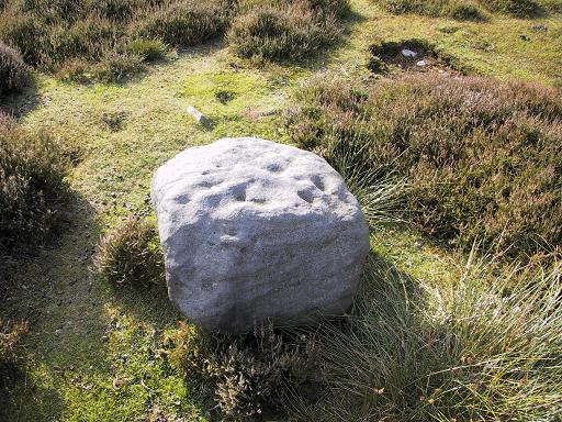
It’s another one of those simple designs: what seems like at least 5 cup-markings on a small rounded rock, with two of them linked together by a groove — possibly natural, possibly man-made — though there may in fact be seven or more cups etched onto its upper surface.  It’s difficult to tell.  It gives you the impression that its present position isn’t its original one and is suggested by Boughey & Vickerman (2003) to have been “moved from pipeline?” close by.  It may even have been dug out and cast here, possibly once being a part of a cairn.  In the Boughey & Vickerman survey they give its OS-coordinate as SE 17163 50527 – and describe it as a “medium-sized, free-standing rock of fine grit. Five cups, some perhaps natural.”  When Richard Stroud and I visited the site, he found the GPS coordinate was SE 17162 50530; and we have to say that instead of describing it as a free-standing rock, it’s a movable stone (though it’d take a bit of effort), that may once have been part of a larger monument.

References:

  1. Bennett, Paul & Chappell, Graeme, Personal Communication, 1993.
  2. Boughey, Keith & Vickerman, E.A., Prehistoric Rock Art of the West Riding, WYAS: Wakefield 2003.

© Paul Bennett, The Northern Antiquarian