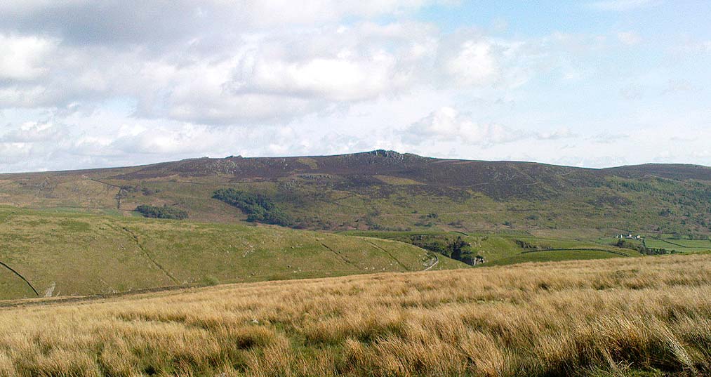
Eller Edge (431), Pock Stones Moor, Thruscross, North Yorkshire

Cup-Marked Stone:  OS Grid Reference – SE 09059 61506

Getting Here

From Appletreewick take the road east through Skyreholme and up Skyreholme Bank, bearing right at the fork in the tracks along the ancient Forest Road.  Keep going till you cross the Larnshaw Beck and keep walking along the track until it runs wallside.  Look over the wall and you’ll see this sloping-chair-shaped rock .  You’re here!
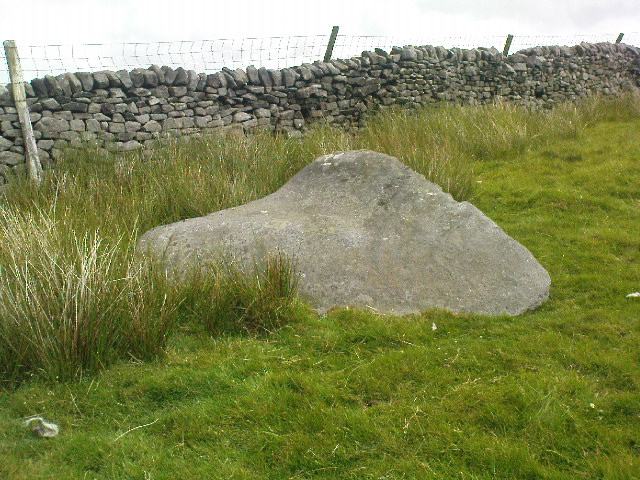
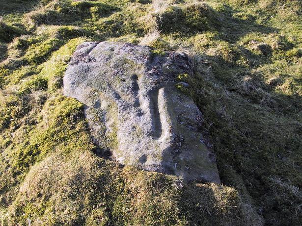
Cup-Marked stone 431

Archaeology & History

Worth looking at if you’re visiting the Spiral Stone of Eller Edge field and its large associate, but otherwise this cup-marked stone is probably only for the purist rock-art mad-folk amongst us!  There are what seem to be three decent cup-marks upon the sloping face of the rock here, with a possible pecked line to the side of two of them — though we have to consider the possibility that a geological condition is responsible for the easternmost cup.  Described in the Boughey & Vickerman (2003) survey simply as:

“Large triangular rock of smooth gritstone, quarried at SE and sloping into ground at W and N.  Three cups on top sloping face.”

Thirty yards up the slope along the wall-side you’ll find carving 432 with its single cup-marking.


References:

  1. Boughey, Keith & Vickerman, E.A., Prehistoric Rock Art of the West Riding, WYAS: Wakefield 2003.

Links:

  1. Eller Edge Rock Art – more notes & images

© Paul Bennett, The Northern Antiquarian

Eller Edge (426), Pock Stones Moor, Thruscross, North Yorkshire

Cup-and-Ring Stone:  OS Grid Reference – SE 08991 61486

Also Known as:

  1. Spiral Stone
Spiral Stone with cluster of cups (image © QDanT)

Getting Here

A slight walk to get here, but well worth it once you arrive!  From Appletreewick, take the road east through Skyreholme and up Skyreholme Bank track, bearing right at the fork in the tracks along the ancient Forest Road.  Keep going and after a couple of zigzags, you’ll cross the Larnshaw Beck.  Keep walking along the track until it runs wallside — and here, go straight down the field for 75 yards (best climbing over the rickety wooden bridge by the stream 50 yards back and walking up).  Although there are a number of other stones hereby, you can’t really miss this.

Archaeology & History

This carved stone and its close associates rest upon the green slopes overlooking the Blands Valley and further across upper Wharfedale and the lands beyond.  The majestic Simon’s Seat rises on the nearby western slope and there in the greater distance, once more reaches the sacred hill of Pendle, with whom so many other ancient sites commune within our northern lands.  It’s hard to say for sure that the Witch’s Hill was of little relevance to this and other stones, but only a fool would ignore the geomancer’s notes about this constant.

Eller Edge carving, looking south (image © QDanT)
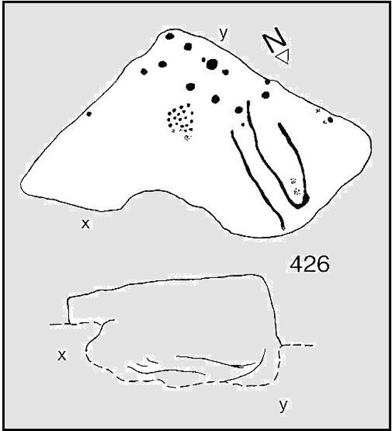
Boughey & Vickerman’s drawing

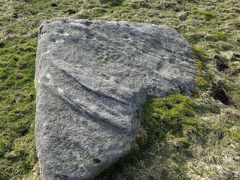
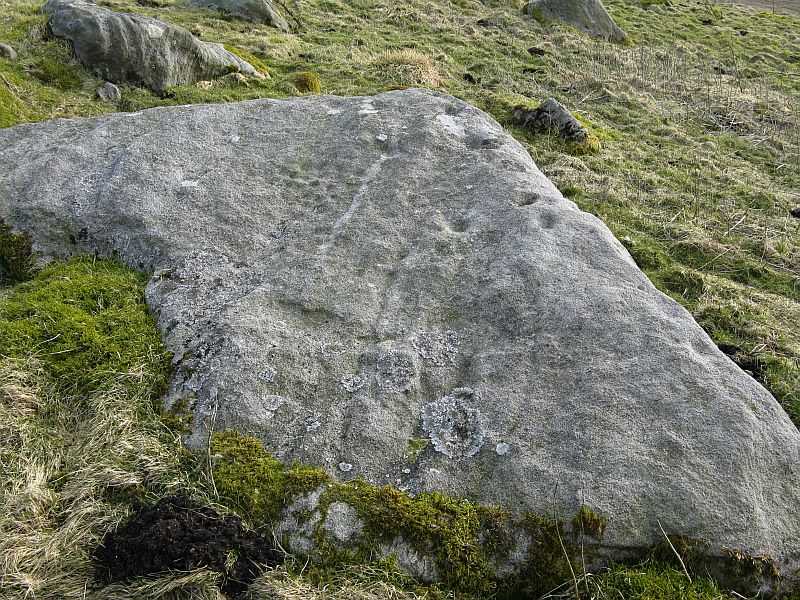
The carving here doesn’t give much clues in any direct sense either.  We have an almost arrowhead-shaped rock with a dozen decent cup-marks or so cut along and near its western side; but the notable curiosity here is the small circular cluster of smaller cup-marks dotted in a near circular mass near the middle of the stone.

When Danny, Paul and I came here the other week, the initial impression of this cluster was one of a primitive solar symbol etched onto the rock; but the more we looked, the more it seemed that these small cups appeared to have been arranged in a very rough spiral lay-out.  Now I know that spirals are damn rare items in rock art (especially in this part of the world), but the more we looked and then subsequently checked Boughey & Vickerman’s (2003) illustration, the more evident it became.  Of course the ‘spiral’ could be merely fortuitous, but I’m not so sure misself.  In discussing this with our field archaeologist later, he suggested getting a rubbing of this part of the stone on his next visit.

The stone was first described by the petroglyph explorer Stuart Feather (1964) and later described by the rock art students Boughey & Vickerman (2004), simply as:

“Large, rough grit rock with face sloping SE down into grass at N.  About twenty cups to W, with three grooves at N corner and group of about twenty small cups at NE.”

A very intriguing carving.  And if you visit here, make sure you check out carving 424 and others in the same field.

References:

  1. Boughey, Keith & Vickerman, E.A., Prehistoric Rock Art of the West Riding, WYAS: Wakefield 2003.
  2. Feather, Stuart, “Appletreewick, WR,” in ‘Archaeological Register, 1963’, Yorkshire Archaeological Journal, volume 41, 1964.

Links:

  1. Eller Edge Rock Art – more notes & images

© Paul Bennett, The Northern Antiquarian

Burhill Kiln Allotment (415), Appletreewick, North Yorkshire

Cup-and-Ring Stone:  OS Grid Reference – SE 07792 61829

Also Known as:

  1. Carving no.415 (Boughey & Vickerman)
Burhill’s cup-and-ring stone (image courtesy ‘QDanT’)

Getting Here

Probably the easiest way is to park up at Stump Cross Caverns on the B6265 road, then walk down the road for 200 yards till you reach the track on your left running over the fields in the direction towards Simon’s Seat.  Walk along the track past the Skyreholme Wall carving, where it starts going downhill and, 100 yards before you reach the fork in the tracks, look in the field on your left.  The other route is to go east through Appletreewick village up to and through Skyreholme as far as you can drive, where the dirt-track begins.  Keep going up till you hit the fork in the tracks.  Go left, then thru the first gate you come to and walk up into the second field up where the notable rock stands out.  If you can’t see it at first, look around!

Archaeology & History

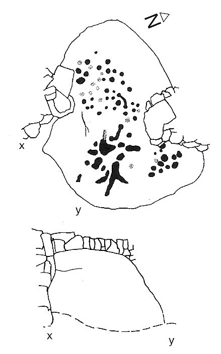
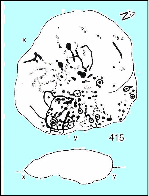
Boughey & Vickerman’s plan of the carving

This carving was rediscovered by Stuart Feather (1964) in one of his ambles in the area — and he would have been pretty pleased when he found this one!  It is the most complex and ornate of all the prehistoric carvings in and around this large open field.  With at least nine cup-and-rings and more than fifty other cups etched onto its rounded upper surface, there are various other lines and grooves linking up some elements of this mythic design. The best ones are on the upright and sloping east-face of the rock, into the rising sun.  In animistic terms the rock is distinctly female in nature.

Illustrated in one of Stan Beckensall’s (1999) works, the rock art students Boughey & Vickerman (2003) also include it in their survey, but give an inaccurate grid reference for the site.  They nevertheless describe it as:

“Large upstanding rock with slightly domed top surface. Most of top surface decorated but weathering makes detail uncertain: over sixty cups, eight or more with rings, many grooves.”

Many other carvings can be found in the area.

References:

  1. Beckensall, Stan, British Prehistoric Rock Art, Tempus: Stroud 1999.
  2. Boughey, Keith & Vickerman, E.A., Prehistoric Rock Art of the West Riding, WYAS: Wakefield 2003.
  3. Feather, Stuart, “Appletreewick, W.R.” in ‘The Yorkshire Archaeological Register, 1963’, Yorkshire Archaeological Journal, 41 (part 162), 1964.
  4. Morris, Ronald W.B., “The Prehistoric Rock Art of Great Britain: A Survey of All Sites Bearing Motifs more Complex than Simple Cup-marks,” in Proceedings of the Prehistoric Society, volume 55, 1989.

Acknowledgements:  Huge thanks to the pseudonymous ‘QDanT‘ for use of the photo in this profile.  Cheers Danny!

© Paul Bennett, The Northern Antiquarian

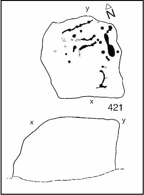
Burnett’s Ridge (421), Appletreewick, North Yorkshire

Cup-and-Ring Stone:  OS Grid Reference – SE 08103 61500

Also Known as:

  1. Carving no.421 (Boughey & Vickerman)
The beautiful stone… (courtesy ‘QDanT’)

Getting Here

One way is to go east through Appletreewick village up to and through Skyreholme (making sure you bear right at the turn and not go up the left turn, which takes you uphill and elsewhere!) as far as you can drive, where the dirt-track begins.  Keep going up till you hit the fork in the tracks, and here, look into the field on your right.   The other way is to park up at Stump Cross Caverns on the B6265 road, then walk down the road for 200 yards till you reach the track on your left running towards Simon’s Seat.  Walk all the way down this till you reach the fork in the tracks.  There’s a gate into the field just yards below the split in the tracks.  Go thru it and walk into the middle of the field where the stone unmistakably calls out for you to go sit with it for a while!

Archaeology & History

Boughey & Vickerman’s plan of the cup-marks

Sat near a ridge due north of the magnificent Simon’s Seat, this faded carved stone gets its name from the field in which it lives — and as Danny’s photo here shows, it’s a fine stone indeed in a very fine setting.  The cup-marks on its top were first described by Stuart Feather (1964), who found there to be around 20 cup-markings on the top, with some grooves — possibly natural, possibly man-made — linking them together.

However, in the fields north of here are a number of other cup-and-ring carvings, but much of the landscape has been damaged by industrial workings.  It makes you wonder how many there used to be here before the industrialists started digging the land up…

References:

  1. Boughey, Keith & Vickerman, E.A., Prehistoric Rock Art of the West Riding, WYAS: Wakefield 2003.
  2. Feather, Stuart, “Appletreewick, WR,” in Archaeological Register, Yorkshire Archaeological Journal, volume 41, 1964.
  3. Morris, Ronald W.B., “The Prehistoric Rock Art of Great Britain: A Survey of All Sites Bearing Motifs more Complex than Simple Cup-Marks,” in Proceedings of the Prehistoric Society, volume 55, 1989.

Acknowledgements:

Huge thanks to the pseudonymous ‘QDanT‘ for use of the photo in this profile.  Cheers Danny!

© Paul Bennett, The Northern Antiquarian


Line Stone, Skyreholme, Appletreewick, North Yorkshire

Cup-Marked Stone:  OS Grid Reference – SE 0732 6251

Also Known as:

  1. Carving no.401 (Boughey & Vickerman)

Getting Here

Skyreholme 401 carving (photo © Richard Stroud)

Along the B6265 Pateley Bridge-Grassington road, roughly halfway between Stump Cross Caverns and the turn down to Skyreholme and Appletreewick (New Lane) is a dirt-track on your right-hand side called Black Hill Road. Walk along here for a few hundred yards till y’ reach the gate on the right. A track meanders downhill to the psilocybin-rich pastures of Nussey Green. Several hundred yards down, to the right-hand side of the track, we find this stone and its several nearby companions. Look around – you’ll find it!

Archaeology & History

I like this carving — I think because of the initial impression it gave, which was one of numeracy and linearity: an unusual quality for a cup-and-ring stone. Those of you with an astronomical or mathematical slant may have a similar response.

Line Stone Carving, Skyreholme

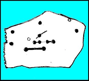
The stone was first described in one of Stuart Feather’s (1964) many short notices.  Its existence then remained dormant until it was eventually listed in Boughey & Vickerman’s (2003) survey on the West Riding rock-art, where they catalogued it as ‘stone no.401.’  The carving comprises of two parallel lines—one quite deep—with cup-marks at either end; one of the lines having another 2 cups along it. A third line at an angle has one or two cups along it aswell.  Several other single cups scatter the rock (forgive my crap drawing of it!).

References:

  1. Boughey, Keith & Vickerman, E.A., Prehistoric Rock Art of the West Riding, WYAS 2003.
  2. Feather, Stuart, ‘Appletreewick (WR),’ in Yorkshire Archaeology Journal 41, 1964.

© Paul Bennett, The Northern Antiquarian

Skyreholme Wall Stone, Appletreewick, North Yorkshire

Cup-and-Ring Stone:  OS Grid Reference – SE 0772 6231

Also Known as:

  1. Carving no.413 (Boughey & Vickerman)

Getting Here

Skyreholme Wall Carving
Skyreholme Wall Carving (after Boughey & Vickerman)

Various ways here, but for the sake of newcomers I’d say it was best following directions from Burnsall.  From here, take the Appletreewick road thru the village, past the left turn a few hundred yards along, and another 500 yards or so there’s a split in the road: take the one on your right!  Follow this up, keeping right (don’t turn into Perceval Hall, tempting though it may be!) and park-up where the road turns into a track.  Walk up the track, past the haunted junction, bearing left uphill up Black Hill Road until you reach the very peak of the track where, in the walling on your left, you’ll see this big boulder.  If you can’t see it, you’re bloody close!

Archaeology & History

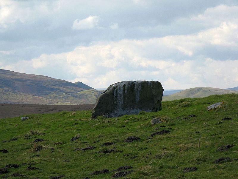
This is at the very peak of Black Hill Road, with excellent views of Simon’s Seat climbing to the immediate south, the prominent and rounded Nursery Knot Hill immediately north, and grand views to peaks east and west. It is very likely this position had something to do with it being deemed worthy of relevance.  The rock itself defines a point along the old boundary line.

Skyreholme Wall Boundary carving

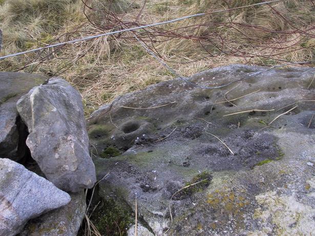
One peculiarity on this boulder is the deep cup-mark with a strange ‘lip’ to it, which has been mentioned by others in the past.  This is surrounded by at least five others cups — not dissimilar to some of the ‘rosary-designs’ of cup-and-rings further north.

The rock art student’s Boughey & Vickerman’s (2003) drawing of this design is pretty accurate — where they call it stone 413 — though it doesn’t actually give this carving the justice it deserves.  They also erroneously tell that some of the cups here are doubtful.

Check it out for y’self.  This is an excellent stone for cup-and-ring lovers! (with plenty of other sites scattered about all round here)

References:

  1. Boughey, Keith & Vickerman, E.A., Prehistoric Rock Art of the West Riding, WYAS 2003.

© Paul Bennett, The Northern Antiquarian

Simon’s Seat, Skyreholme, North Yorkshire

Sacred Hill:  OS Grid Reference – SE 0788 5981

Getting Here

Simon’s Seat in the centre & the Lord’s Seat immediately east

Tons of ways here.   To those who drive, take the Grassington-Pateley Bridge (B6265) road and a couple of miles past the village of Hebden, you’ll see the high rocks climbing on your southern horizon, with another group of rocks a few hundred yards along the same ridge.  That’s it!

Archaeology & History

This is an awesome site, full of raw power. It commands a brilliant view all round, but it is the north which truly draws the eye’s attention. Beneath the great drop of this huge outcrop is the haunted and legendary Troller’s Ghyll. The scent of as yet undisclosed neolithic and Bronze Age sites purrs from the moors all round you and there can be little doubt that this was a place of important magick in ancient days.

What seems to be several cup-markings on one of the topmost rocks are, to me, authentic. Harry Speight mentioned them in his 1892 work on the Craven and Northwest Yorkshire Highlands – but there are a number of other rocks in this giant outcrop with “possibles” on them.

Folklore

The name of this great rock outcrop has long been a puzzle to historians and place-name experts.  One tale that was told of Simon’s Seat to the travelling pen of one Frederic Montagu in 1838, told that,

“It was upon the top of this mountain that an infant was found by a shepherd, who took it to his home, and after feeding and clothing it, he had the child named Simon; being himself but a poor man, he was unable to maintain the foundling, when it was ultimately agreed to by the shepherds, that the child should be kept “amang ’em.”  The child was called Simon Amangham and the descendants of this child are now living in Wharfedale.”

The usually sober pen of Mr Speight thinks this to have been one the high places of druidic worship, named after the legendary Simon Druid. “It is however, hardly likely,” he wrote, “that he ever sat there himself, but was probably represented by some druidical soothsayer on whom his mystic gifts descended.”

I’ve gotta say, I think there’s something distinctly true about those lines. Visit this place a few times, alone, during the week, or at night – when there’s no tourists about – and tell me it isn’t…

References:

  1. Bogg, Edmund, Higher Wharfeland, James Miles: Leeds 1904.
  2. Montagu, Frederic, Gleanings in Craven, Simpkin Marshall: London 1838.
  3. Speight, Harry, The Craven and Northwest Yorkshire Highlands, Elliott Stock: London 1892.

© Paul Bennett, The Northern Antiquarian

Devil’s Apronful, Appletreewick, North Yorkshire

Cairn:  OS Grid Reference – SE 07485 59355

Getting Here

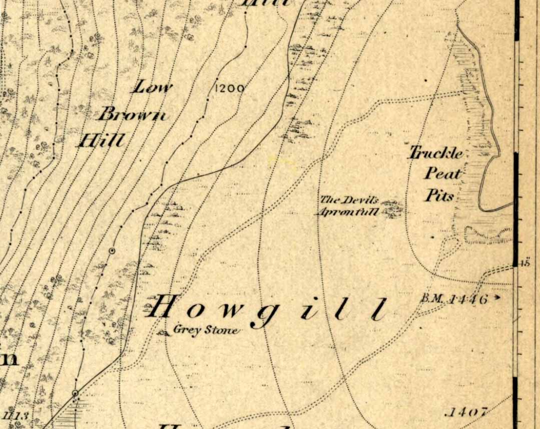
Devils Apronful on 1853 map

An excellent spot with fantastic views. There’s many ways to approach the place, but a good one is from the roadside by Howgill, then following the track uphill until you reach the moor, then head towards the spectacular and legendary, Simon’s Seat (which folklore ascribes to be named after the great druid, Simon Magus). You’ll pass an old Grey Stone (two large rocks) from which you can espy the old tomb if you stand on top of ’em. Keep walking uphill and it’s about 100 yards off the footpath to your right. A large boulder is nestled just beneath the tomb itself, which stands out on a ridge.

Archaeology & History

When Harry Speight visited here (1900) he described it as being 40 yards in circumference. He also described “an upright stone below the cairn” with apparent cup-markings on the west-side.  I’m not quite sure where this has got to – but the site has shrunk somewhat since Speight’s day.  It’s only about 20 feet across now, and the middle of it has been hollowed into a grouse-shooting butt for the toffs!

About 100 yards southeast (towards the Truckle Stones) are the remains of some neolithic walling in a straight line.

Folklore

One of many old tombs in our northern hills said to have been created by the devil who, as usual, accidentally dropped some stones he was carrying. The old folklorist Thomas Parkinson (1888) said the following of this place:

“The Apronful of Stones is a group of rocks heaped together in delightful confusion, their disorder and name being thus explained:  Once upon a time—whether when he built the bridge over the valley, or at some other time, the record saith not—the Devil was determined to fill up the ravine, or gill, of the Dibble. For this purpose he was carrying these enormous crags in his apron, when, too intent upon his object to properly observe where he placed his feet, he caught with one foot upon the top of Nursa Knott, and, stumbling, the strings of the apron broke, and the contents were thrown upon the ground as they now appear. It is also said of them that if any of them, even now, were to be removed, they would certainly be brought back to their original place during the succeeding night.”

Another legend tells that the Devil’s Apronful is also the grave of some local unnamed hero.

References:

  1. Parkinson, Thomas, Yorkshire Legends and Traditions – volume 1, Elliott Stock: London 1888.
  2. Speight, Harry, Upper Wharfedale, Elliott Stock: London 1900.

© Paul Bennett, The Northern Antiquarian