Standing Stones (destroyed): OS Grid Reference – NS 6957 4524
Archaeology & History
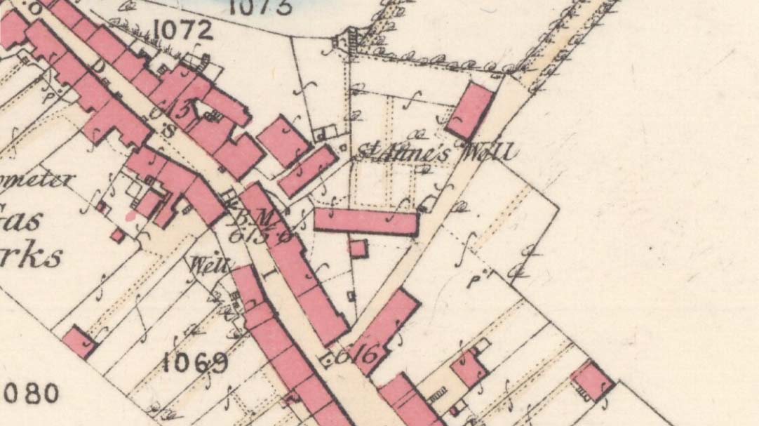
Threestanes on the 1864 OS-map
It seems that nothing remains of the three standing stones that gave rise to the place-name of Threestane Farm, at the top of Threestane Lane, on the northwestern outskirts of Strathaven. We have no details on the size and form of the stones, nor when they were destroyed, but can presume that it was sometime prior to the Ordnance Survey lads coming here in 1858.
One local antiquarian, Maggie Overett, told that, “Slightly to the north east of Threestanes farm and near to the A726 Strathaven to East Kilbride road used to stand a farm called Westfield(still currently shown on my Google Earth) it was demolished over a year ago. Just behind what was the farm is a slight incline with what appears to be a standing stone. I have not been able to gain access to the site because of barriers put up by whoever owns the plot…… But it’s close enough to tie in the Threestanes estate…….and only a short distance from the known Strathaven Stane.”
Any further information about these lost monoliths would be greatly appreciated.
References:
Bryson, J.M., Handbook to Strathaven and Vicinity, Townehead: Strathaven n.d.
Healing Well (lost): OS Grid Reference – NS 593 648
Also Known as:
Ratten Well
Archaeology & History
This long lost well near the middle of Glasgow was known by this name as early as 1345. Close to the River Clyde, a wooden structure was built around the well—a stock—and its waters were used by local fishermen. A local fair used to be held hereby. It has long since been built over and its original position no longer seems to be known.
Folklore
The old traditional tale behind this site was written in a short piece in the Scottish Journal of Topography oh so long ago now… One pseudonymous “R.M.S.” said that:
“Stockwell Street in the city of Glasgow, is pretty well-known, and everybody in the locality is aware of the ‘Ratten Well’ with its impure waters. It is said that, in days of yore, when Sir William Wallace had occasion to be in that quarter, he and his party met a band of englishmen at the well. A battle ensued, and the bodies of the englishmen, who were defeated, were thrown by the incensed Scots into the well. “Stock it well! Stock it well” exclaimed Wallace, from which expression the street received its name. So says tradition; and it is even yet believed that the bad quality of the water is owing to the putrefaction of the dead bodies of the englishmen.”
The one thing we can be certain about in this story, is that the Scots wouldn’t be stupid enough to dump dead bodies into their own fresh water supplies. We must assume some englishman or dodgy corporation was responsible for that bit!
Long since lost it would seem, in a search for this legendary site over the weekend with Gordon, Aisha and Lara, I’m still not certain of the actual status of the site. Although we found a very fresh water supply still running not far from where the old OS-map showed the original holy well to be, it may be a completely different water source.
There are hardly any references to the spring and those that exist are scant. In the early 1860s, St. Ane’s Well was mentioned briefly in the Object Name Book of the area:
“This is a good spring well in the southern part of the town of Strathaven. It is commonly called Tun’s (Tan’s?) Well, but this is an abbreviation of the name.”
Lara plays at a nearby well
Looking down on the waters
More recently, thanks to a communication from the local historian Robert Currie, more information has come to light about the well. It was described in the local history work by Mary Gebbie (1880). Mr Currie told me:
“In her Sketches of Avondale and Strathaven…we read: “In a lane off Tod’s Hill was the famous Tann’s Well – obviously a corruption of the celebrated water saint, St. Anne. This spring has within a few years completely dried up. Access was easily had from the castle to it, over the draw-bridge, which is said to have rested on the ledge of the ground and rock on which the fifth house is built south of the bridge. Before this aperture was built up, the inhabitants around took advantage of the pathway for drawing water from the Pomillion, at a place called the Fairy Pool. A little above this comes the Dove Castle; and a half a mile further out is the Gallow Hill.”
He continued:
“That said, the current siting of St. Anne’s Well is located on Lesmahagow Road with (the) site being almost opposite the Council houses bordering on Station Road (there is currently a mini-roundabout near the locus). In recent years the site has become obscured but in my own living memory there was once a plaque authenticating the site and with a garden seat thereby.”
In searching through their own library, Mr Currie and his wife came across more about the site in William Downie’s (1979) book on Strathaven, in which he wrote:
“A small lane off Todshill went down to a cluster of houses called St. Anne’s Well nestling on the sloping ground beside the mill dam. In 1911 these houses were acquired and demolished by the Town Improvement Committee. A row of houses backing backing on to Powmillon Burn were also demolished at the same time and a retaining wall with railings erected, so opening up a very fine view of the castle and burn etc.”
The dedication here to the mythic figure of St. Anne (mother of the Virgin Mary and grandmother of Jesus) is isolated and mysterious. No church is dedicated to her in the area, nor other relative christian remains. Her appearance in Strathaven is something of an oddity. There was a Duchess ‘Ann’ Hamilton of Strathaven Castle who lived 200 yards away at Strathaven Castle on the other side of the river that might have given her name to the well, but this is very unlikely. More probable is that St. Anne was used as the mythic figure who covered an earlier dedication to the prima mater, or Cailleach—although there are no remains that relate to Her either. However, the existence of St Mary’s church and an associated well to the north, along with a burn dedicated to a “maiden” in the same parish to the northwest add to the cailleach’s potential…..but all tales of Her have seemingly been forgotten.
…So it seems that the spring of water that Lara, Aisha, Gordon and I came across was obviously not the same place, but exists just below the roadside where the disused railway line is. It’s close to St Anne’s Well – but is not the same water source.
References:
Downie, Fleming, A History of Avondale and Strathaven, Eric Moore: Glasgow 1979.
Gebbie, Mary, Sketches of the Town of Strathavon and Parish of Avondale: Historical & Traditional, John Menzies: Edinburgh 1880.
Acknowledgements: Considerable thanks must be given to Robert Currie, BA Hons, who sent us additional information enabling a more informative and accurate site profile for this holy well. Thanks Bob! Also huge thanks again to Aisha Domleo, Lara Domleo, Unabel Gordon and their frobbling Leonidus!
In a region where, today, the busy city spreads its urban tendrils on the south-side of Glasgow, there could once be found an excellent multi-ringed prehistoric petroglyph. It was located in the landscape of Langside and Battlefield, betwixt where now large houses grow, a few hundred yards south of the hillfort-topped Queen’s Park. According to the official records, it was all alone – but I don’t buy that for one minute! (petroglyphs rarely occur in isolation)
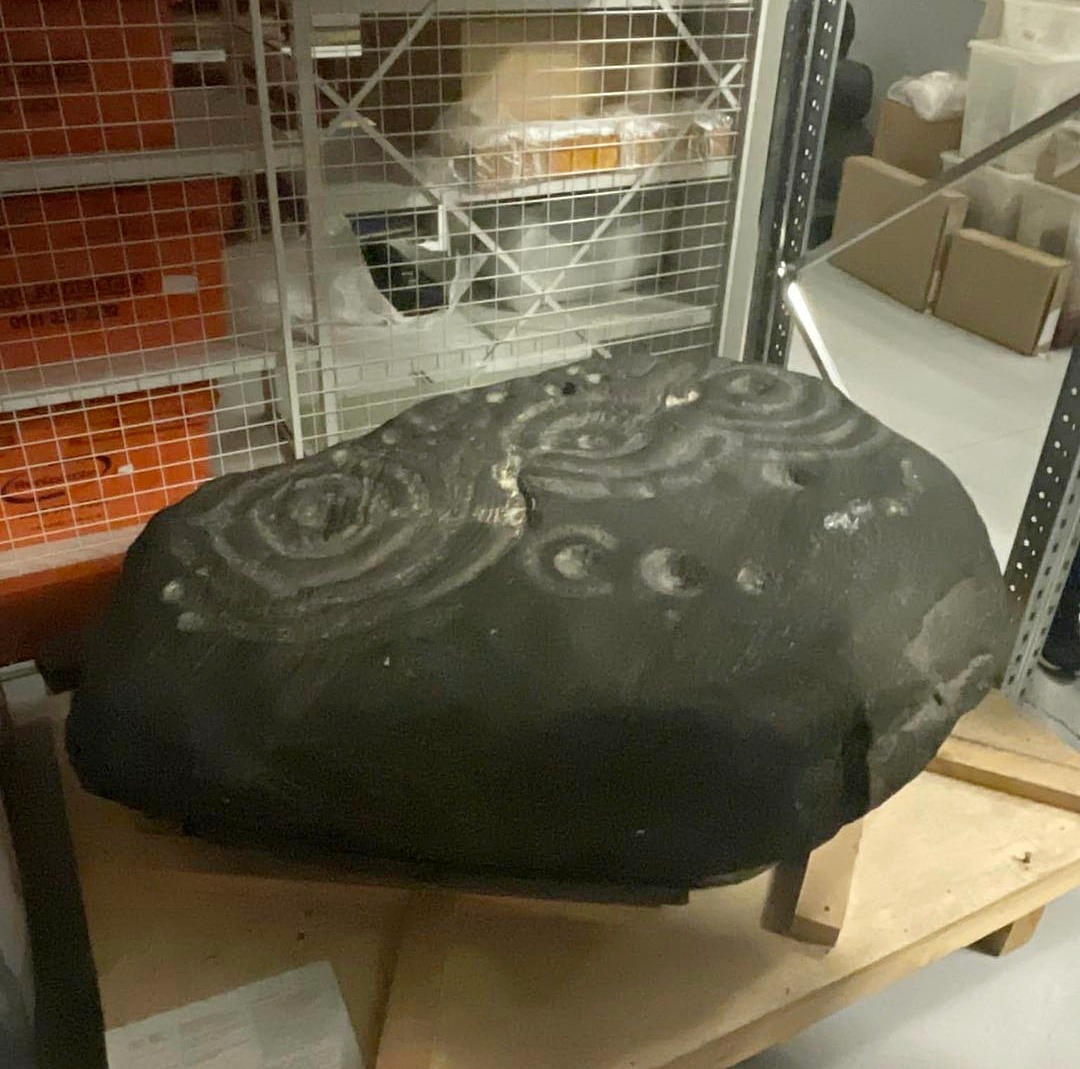
The carving in Kelvin Hall, Glasgow (photo by Donny McIntyre)Langside House carving
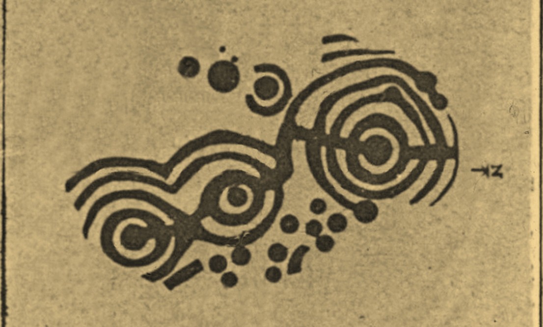
Before being noticed by archaeologists, the stone was apparently being used as a stone seat in the woods on which people would sit, rest and admire the view! It was probably a part of a larger monument, perhaps a cairn of some sort. As we can see in the sketches that were made of it, along with Donny’s photo of it (right) in the Glasgow Museum store-rooms, the stone was part of a larger piece and was likely to have had companions, but records seem to be silent on the matter. The most detailed description of it comes from the pen of northern antiquarian Fred Coles (1906), who gave us the following literary portrait:
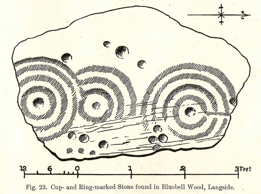
“The first notice of the Stone incised with the design shown below was due to Mr W. A. Donnelly, who contributed a description and a sketch to The Glasgow Evening Times of 25th June 1902. Later, Mr Ludovic Mann, at my request, sent me certain notes he had taken of the cup-and-ring-marks. But prior to this, the Stone itself had, on the instigation of Mr Donnelly, I think, been removed from its site in the wood, and placed near one of the entrances to the new Kelvinside Museum. There I saw it and made measurements in July 1903.
“The Bluebell Wood lies in a curving line to the west and south of Langside House, and the cup-marked Stone was at a point in the southern extremity of the wood, above and north of the river Cart. It is interesting to be able also to record that the longer axis of the Stone lay almost precisely north and South, and the opposite axis east and west.* The Stone is of a hard, whitish sandstone, a good deal weathered and rounded at the edges. It measures 4 feet 9 inches in length and 3 feet 2 inches in breadth, and varies in thickness from 2 feet 6 inches to 1 foot 7 inches. The striation of the Stone has helped to efface the cuttings which, though perfectly clear and measurable, are shallow in proportion to their width. And this feature I have endeavoured to portray in the accompanying illustration (above). Beginning at the north end of the Stone, there is one cup placed just where the outermost ring of that group touches the edge of the Stone. The ring has a groove leading towards but not into a central cup, and four other cups are placed on the two outermost rings, there being four rings in this group. The middle group consists of a central cup and three rings, flanked on the west by a row of three cups (one of which is the largest of all), and on the east by a double row of six cups, three of which are almost obliterated. This middle group is imperfectly concentric, two of its arcs running into the fourth ring of the group on the south, which has a fine deeply picked central cup. All the better-preserved rings are very nearly 1½ inches in width of cutting.
“The diameters of the outermost rings in each group are: of the north group, 1 foot 9 inches; of the middle group 1 foot 5 inches; and of the south group 1 foot 7 inches. The cups vary in diameter from 3 inches to 1½.
“Considering the extremely easily weathered nature of this Stone, and the fact that its sculptured surface has already suffered much ill-usage, its present position, near the entrance of the Art Galleries, entirely unprotected by a railing and exposed to all sorts of abuse by casual passers-by as well as the weather, is not a fit and proper place for a Stone of such interest.”
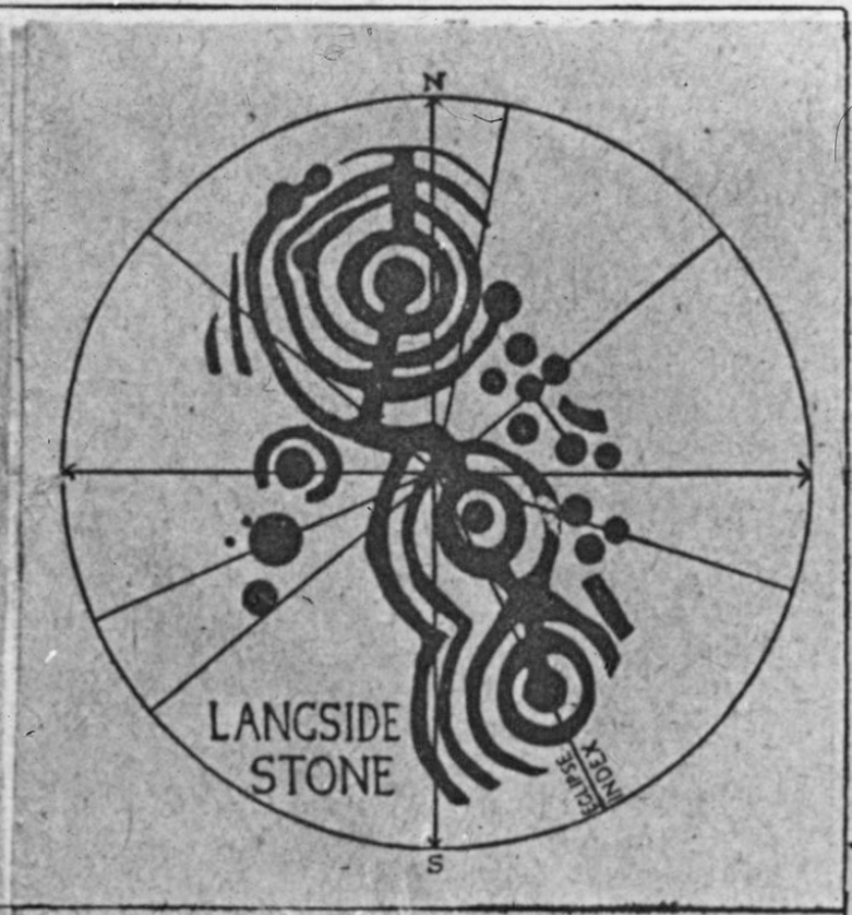
A few years after this, the local historian Ludovic MacLellan Mann (1930) wrote a piece for the Glasgow Herald, in which he thought that both this and another carving in the area,
“commemorate chiefly…an eclipse of the sun seen in Glasgow district in the year 2983 BC, at three o’ clock in the afternoon of the sixth day after the Spring Equinox.”
Mann’s 1930 sketch
A fascinating idea… Mann was intrigued by the theory that petroglyphs represented astronomical events or maps of the skies – and we know from cultures elsewhere in the world that some carvings had such a function; but it’s not integral to all carvings by any means.
The stone was included in Ron Morris’ (1981) survey, merely echoing the description of Fred Coles, adding nothing more. And so it seems that the carving is still in the museum somewhere. Canmore has it listed as “Accession no: 02-78”. Does anyone know of its present situation? Can anyone get a photo so we can give it a more fitting site profile? It looked a damn good carving! And, if anyone lives nearby, I note that there are small patches of the old woodland still visible on GoogleEarth: therein, perhaps, a diligent explorer may just find another carving….
Mann, Ludovic MacLellan, “The Eclipse in 2983 B.C. – Discovery near Glasgow,” in Glasgow Herald, 17.09.1930.
Morris, Ronald W.B., “The Cup-and-Ring Marks and Similar Sculptures of South-West Scotland,” in Transactions of the Ancient Monuments Society, volume 14, 1967.
Morris, Ronald W.B., The Prehistoric Rock Art of Southern Scotland, BAR: Oxford 1981.
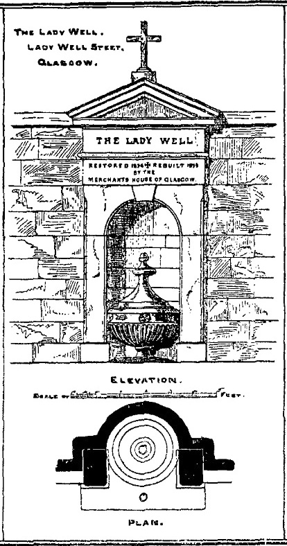
Get yourself to Glasgow Cathedral—wherein you’ll find St. Mungo’s Well—and walk down John Know Street. A coupla hundred yards down, across the road is a small street called Ladywell Lane (there’s no signpost for it though), running below the cemetery and leading to the back entrance of the giant Tennent’s Brewery. At the bottom of this, up against the wall on your left, is the Lady Well.
Archaeology & History
The origins and early traditional history of this once famous sacred well are sadly lost due to the intrusion of industrialism. It was obviously a place of some considerable repute and lent its name to local quarries and fields hereby. Used extensively by local people for countless centuries, things were to change in 1715 when the waters of this and other wells were to be kept clean by one John Black, “at a salary of 400 merks yearly.” The Glasgow historian Eyre-Todd (1934) told that,
“Black was to furnish them with chains, buckets, sheaves, ladles, and other necessary graith, aswell as with locks and iron bands. He was ‘to cleanse, muck and keep them clean,’ and to lock and open them in due time, evening and morning. In case of failure he was liable to a penalty of £100 Scots.”
Lady Well in 2015
Lady Well in 1883
That’s a helluva lot of money in those days! Even when M’Ure (1736) described it, only in passing, he had nothing to say about its curative properties or local rites. Once the Industrialists take control, the ways of local people are sanitized, sterilized and ‘progress’ outlaws tradition. The only reference to an earlier sacrality is in Mr Russel’s (1883) article, where he said simply, that the Lady Well was “so called after a fountain at the bottom of the Craigs…sacred in Popish times to the Virgin.”
The construction that we see today—of the well in its little enclave—was first built in 1835-6. The waters became polluted after they were redirected below the Necropolis and have not been used since (although they still flow out of the wall a couple of yards to the right, stinking!). The architectural feature was cleaned up and restored by the local brewery in 1983.
The site may have gained its name from one Lady Lochow, who lived nearby and built a hospital at the old Gorbels in the 14th century—but we might never know the real truth about the origin of its dedication. However, an intriguing ingredient relating to the dedication of the Lady Well is the incidence of a St. Anne’s Street that used to exist immediately to the east, as seen on the 1865 OS-map above. St. Anne may well be the mythic character behind the naming of this Lady Well, although I can find no literature to prove this. In the christian mythos, St. Anne was a very important character indeed: the mother of the Virgin Mary no less! However, as hagiographers from Attwater (1965), to Baring-Gould (1898) and Butler (1866) all tell, her biography is piecemeal—which is most surprising considering she was JC’s granny! Anne’s festival date was July 26 (a couple of days after Sirius enters the northern hemisphere); she was the patron saint of midwives, grandmothers and also miners, who invoked her as the deity who produced gold and silver—akin to the Earth Mother Herself! It’s obvious that Anne’s original mythic nature was subdued, as she represented an archaic root of matriarchal triplicity of the Virgin, the Lady and Old Woman and not the patriarchal triplicity of the incoming christian cult. The christian mythos at this Lady Well (as elsewhere) replaced one facet of the indigenous prima mater in Glasgow, known as the Cailleach—as shown in her attributes of midwife, grandmother and the deep Earth. If local historians can find field-names or wells dedicated to the Maiden, the Lady and the Carlin (or their variant titles) nearby, the lost layers of archaic Glasgow’s indigenous animistic folk memories could be mapped out once again…
References:
Attwater, Donald, The Penguin Dictionary of Saints, Penguin: Harmondsworth 1965.
Illustrated on the 1864 Ordnance Survey map, right by the roadside a hundred yards or so east of Braidwood House, once stood a proud standing stone – but sadly there are no remains of the monument today. It was said by Mr Groom (1882), in his encyclopaedic Gazetteer of Scotland, that the stone was “supposed to have been a milestone on Watling Street,” but we have no way of verifying this with any certainty. However, a similar association was conferred upon the stone by local people when the site was visited by the reverend John Wylie in 1839, when it was still standing. Writing in the Statistical Account of Carluke, Wylie told,
“It is supposed to have stood at the side of a Roman Road, passing from Lanark, across the bridge of the Mouse beneath Cartland Crags, through Lee Valley, across Fiddler’s Burn at Chapel, and thence by Braidwood into the main street.”
The last record we have of the stone still being in position is from the 1898 OS-map, but sometime thereafter it was uprooted and destroyed. Any further information about the stone would be gratefully welcomed.
References:
Groom, Francis H. (ed.), Ordnance Gazetteer of Scotland – volume 1, Thomas C. Jack: Edinburgh 1882.
Royal Commission on the Ancient & Historic Monuments of Scotland, Lanarkshire: An Inventory of the Prehistoric and Roman Monuments, HMSO: Edinburgh 1978.
Cup-and-Ring Stone (lost): OS Grid Reference – NX 709 489
Archaeology & History
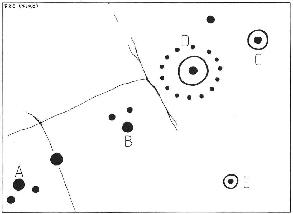
One of the lost High Banks carvings
The drawing here is another by the legendary Fred Coles, previously unpublished until Maarten van Hoek (1990) brought it out of the dusty archives of the Stewartry Museum, Kirkcudbright, and described it in his article on prehistoric rosette motifs. As with its fellow carving of High Banks 2, the location of the site remains unknown; and van Hoek wondered whether these two lost carvings “could have been located at the spot where now the little quarry at High Banks site is found.” Let’s hope not!
References:
Morris, Ronald W.B., The Prehistoric Rock Art of Galloway and the Isle of Man, Blandford: Poole 1979.
van Hoek, M.A.M., “The Rosette in British and Irish Rock Art,” in Glasgow Archaeological Journal, volume 16, 1990.
Cup-and-Ring Stone (lost): OS Grid Reference – NX 709 489
Archaeology & History
One of the lost High Banks carvings
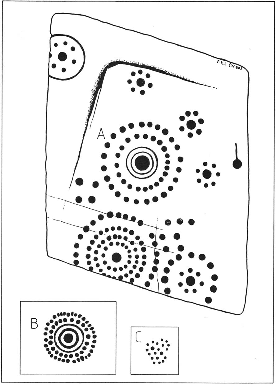
This impressive carving was found somewhere in the vicinity of the well-known High Banks (01) cup-and-ring menagerie, with its clustered mass of cups and multiple rings. And the carving we see here possesses something of a similarity with its complex neighbour—but it remains lost.
The drawing was done by our old Scottish megalithomaniac Fred Coles, who discovered the carving when he visited the area around the beginning of the 20th century. It remained unpublished until fellow rock art student Maarten van Hoek (1990) explored the region and found it hiding away in the archives at the Stewartry Museum, Kirkcudbright. The multiple rings of cups surrounding central cups and cup-and-rings are very rare things indeed and this carving is utterly unique in the British Isles.
In Coles’ drawing, as well as the large carving, we have two other elements below, boxed. These are taken from a notebook found in the same Stewartry Museum and thought to have been done by a Mr G. Hamilton around 1866. In the lower-box, the double-ringed cup with its surround of two more rings of cup-marks was suggested at first by van Hoek (1990) to possibly be the same carving as that found by Coles. But he questioned this, sensibly, as the carved design ‘B’,
“comprises 35 cups (its diameter stated to be 21 inches / 51cm), whereas Coles’ diagram of ‘A’ shows only 24 outer cups. The unknown artist moreover says that, ‘The above (B) is one of a splendid group on Banks Farm.’ So this rosette (B) might be a completely different specimen altogether.”
I have to agree with him. In the second smaller box, ‘C’, the drawing of the cluster of cup-marks is taken from the same 19th century notebook in which the author said there was a cluster of
“70 to 100 small cups without any apparent system, except being in a group of 7 with cup in the centre—also 3 or 4 circles.”
No other details were given. Petroglyph explorers in the area should keep their senses peeled when meandering about here, for this and other missing carvings (High Banks 3).
References:
Morris, Ronald W.B., The Prehistoric Rock Art of Galloway and the Isle of Man, Blandford: Poole 1979.
van Hoek, M.A.M., “The Rosette in British and Irish Rock Art,” in Glasgow Archaeological Journal, volume 16, 1990.
This is nice n’ far north indeed – north-west Uist in fact! Hit the A865 road northwest to the village of Ceann a’ Bhaigh. By the little church at the little crossroad, take the track on your right which leads you into the hills. Go all the way to the end of this track and walk straight north for a couple of hundred yards, as if you’re heading up the hill, Toroghas, in front of you.
Thom’s drawing of the Stones & possible alignments
Archaeology & History
Here are two small standing stones, each not much more than three-feet tall, about 40 yards apart. Alexander Thom (1984) looked for astronomical alignments here, but found very little, merely commenting: “From here a number of sites are visible, but the (easternmost) stone might be said to indicate Craig Hasten or Deaskeir Islet.” In his own analysis of the site, Clive Ruggles (UI23 – 1984) also found such astronomy lacking here.
Folklore
In Thom, Thom & Burl’s (1990) description of these two small stones, Aubrey Burl mentioned how “their name is similar to the stones on Skye called ‘Na Fir Bhreige’, or ‘the false men’. This has been variously interpreted as meaning men who were turned to stone for being unfaithful to their wives or, alternatively, to stones that from a distance resembled men.” Which is apparently the tale here. (see Grinsell 1976)
Comparative religious studies clearly indicate that legends of petrified beings are representative of the spirits of the ancestors residing in the said stones or other artifact. If there’s any validity to this ingredient, it would imply that some prehistoric burials can be found nearby — though my archaeo-records show nothing (but that doesn’t mean they’re not there). If there anyone goes wandering hereabouts in the near future, see if you can find any tombs in the locale.
References:
Beveridge, Erskine, North Uist: Archaeology and Topography, William Brown: Edinburgh 1911.
Ruggle, C.L.N., Megalithic Astronomy, BAR: Oxford 1984.
Thom, A., Thom, A.S. & Burl, A., Stone Rows and Standing Stones, vol.1, BAR: Oxford 1990.
The nature of this site seems a little disputed. Shown on modern OS-maps and cited as being visited and seen in April 1967, the Canmore website also describes it in the present tense — but when I.A. Crawford (1965) wrote of this site he told that, “this standing stone…has been destroyed in fencing operations” — i.e., building a fence or wall, not some doods having a fencing fight!
Equally curious would be the stature of the site; as in the Royal Commission report (1928), the stone was told to be only 2-feet tall — which would mean that if this site is included as an authentic archaeological site, then we’re gonna have to double or treble the number of standing stone sites nationally! There are masses of ‘monoliths’ two-feet tall and above which are in the ‘natural’ category. But this stone, for whatever reason (the folklore probably), has been granted the providence as an authentic standing stone.
Folklore
Tradition told that this old stone was “alleged to mark a battle site” in ancient days. The variation on this theme tells that the stone marked the grave of a man who was slewn in battle here. Seems likely that there will be prehistoric tombs nearby…
References:
Crawford, I.A., ‘Carra Bhroin, S.Uist,’ in Discovery & Excavation in Scotland, 1965, SRG & CBA 1965.
Royal Commission on the Ancient & Historical Monuments & Constructions of Scotland, Inventory of Monuments and Constructions in the Outer Hebrides, Skye and the Small Isles, HMSO: Edinburgh 1928.