Armshaw Lowe, Oxenhope, West Yorkshire

Tumulus?:  OS Grid Reference – SE 04422 35130

Getting Here

Armshaw Lowe on 1852 map

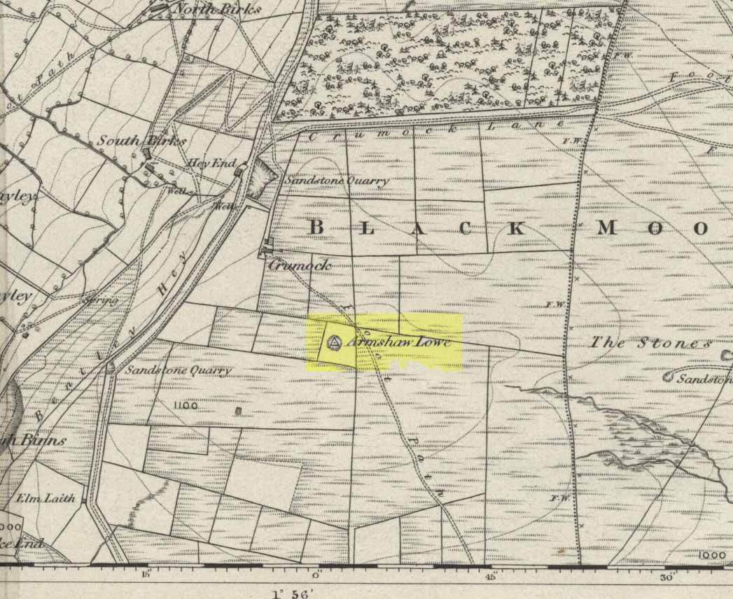
Go along the B6141 from Denholme to Oxenhope, turning right just by the bend which drops into Oxenhope, and head along the small road to Upwood Park camping site. Just before here is the Grange Park Animal sanctuary.  Ask there to walk onto the field behind, where you’ll see a rise in the land, as you can see on the rather poor photo I took from the east-side.

Archaeology & History

Although ascribed on early OS-maps as a tumulus (and still shown as an antiquity on the modern ones), this site appears to be simply the end-point along a geological ridge, starting a few hundred yards east of here, consisting of an upsurge of rocks covered in earth and nothing more. A survey of the place done by Bellamy in 1970 (Yorkshire Archaeological Journal, 42:6, 1970) seems to indicate the same. To those who want to test the theory, start by exploring it from Cullingworth Moor and walk along the ridge itself. It seems pretty clear.

Armshaw Lowe - looking west
Armshaw Lowe – the small mound in centre of photo

The “antiquarian” element to the site seems to originate in its positioning in the landscape. Armshaw Lowe is on the topmost point of the hills hereabouts, with 360-degree views all round, commanding excellent sights all round. But it’s perhaps the word ‘lowe’ that might be the important bit here, as in old english it can mean an old moot or meeting spot — which it may well have been for local tribes.  It is may be this element that gives Armshaw Lowe its lingering antiquarian status.

Check it out for yourselves and see what y’ think. I went up here to see an old burial mound, but found only a decent geological feature atop of local hills. But me ‘n’ the archaeologists might be wrong…

References:

  1. Gomme, G.L., Primitive Folk-Moots; or Open-Air Assemblies in Britain, Sampson Low: London 1880.

© Paul Bennett, The Northern Antiquarian


Clach a’ Phoanais, Strontian, Inverness-shire

Standing Stone:  OS Grid Reference – NM 81581 61360

Also Known as:

  1. Branks Stone

Getting Here

As you enter the village from the east, onto the A861 road, the Strontian Hotel is on the right-hand side of the road and you can’t fail to notice. Stop!

Archaeology & History

Clach a’ Phaonais on 1872 map

Shown on the first edition OS-map of the region in 1875, this old worn standing stone, more than six-feet tall, can be seen at the edge of the drive.  There’s an iron ring is attached to it, which I thought might have made it an old Bull Stone in bygone days, but no such lore is remembered.  Also known as the Branks Stone, it’s Gaelic name probably means the ‘stone of penance,’ and folk were chained to it in eaelier days for bad behaviour.  It was widespread across the Highlands to tie criminals to stones and wooden poles, naked, for 24 hours and let the midges get to them.  Crime was down to a minimum up here!

Folklore

As the locals at Strontian Hotel told me (thanks Finlay), “several stories have emerged locally. It marks a clan chief’s grave, a sighting stone for the equinox but the most plausible one is based on the fact that there is an iron ring on the side of the stone facing the loch and it was used to tie up barges taking lead from the local lead mine.  It supplied the raw material for shot during the Napoleonic and Crimean wars.”

Aknowledgements:  Big thanks to Anne and the Megalithic Portal for additional help on this one.

© Paul Bennett, The Northern Antiquarian


Burwains, Foulridge, Lancashire

Cairn (destroyed):  OS Grid Reference – SD 888 421

Archaeology & History

Burwains on the 1848 map

The place-name burwain is an early Old English word meaning “a cairn or tumulus”.  It has variants such as borrans, borwen and borwans.  In the developing survey by Parsons & Styles (2000), other linguistic examples are given, all of which point to the same thing, i.e., a prehistoric burial of one form or another.  Also, in 19th century northern English dialect, Wright (1898) told that borrans is “a cairn, a heap of loose stones”—which is what used to exist hereby.

The fact that there is a place-name telling of its existence implies that it was a cairn of some size, but sadly all remains of it have long since gone.  All that we’ve got left is the name of Burwains house on the early Ordnance Survey maps.  Built on a hilltop rise, which is a common construction spot for such sites up and down the country, it’s possible that the cairn was destroyed when the Foulridge Lower Reservoir was built in 1793, with the mass of stone used in its construction (the reservoir also kept the name of Burwains lake for sometime).

References:

  1. Clayton, John A., Valley of the Drawn Sword, Barrowford Press 2006.
  2. Parsons, D.N. & Styles, T., Vocabulary of English Place-Names – volume 2, EPNS: Nottingham 2000.
  3. Smith, A.H., English Place-Name Elements – volume 1, Cambridge University Press 1954.
  4. Wright, Joseph, English Dialect Dictionary – volume 1, Henry Frowde: London 1898.

© Paul BennettThe Northern Antiquarian

Lister Well, White Moor, Barnoldswick

Healing Well:  OS Grid Reference – SD 8695 4412

Getting Here

Lister Well on 1853 map

You’re a bit spoilt for choice in terms of how your reach this spot, high upon White Moor – which is south of Barnoldswick, west of Salterforth, northwest of Foulridge, north of Barrowford, or northeast of Blacko.  Whichever route you end up taking, you’re going uphill onto the heights near Weets Hill – and find the old trackway which bisects White Moor and has the rather tell-tale name of Lister Well Road!  It’s roughly halfway along the route, right by the trackside.

Archaeology & History

Lister Well, White Moor

History and folklore here have long been silent (though I aint checked the Annals of Barrowford, which may prove useful).  A local land-owner told us that the original trough had been uprooted a few decades back when the gas- or electricity-board (he can’t remember which) did some work hereabouts and uprooted the stone trough into which the waters ran and, for sometime, caused the complete destruction of the supply.  But its waters eventually re-emerged from the Earth, trickling into the grassy drainage line on the southern-edge of the track before going under the wall and down the moorland slope.

If you like a good walkabout with good views to behold, get y’self up here and have an amble.  Tis a damn fine place, with a lot of forgotten history embedded in the landscape.

© Paul Bennett, The Northern Antiquarian


Standing Stone, Foulridge, Lancashire

Standing Stone:  OS grid reference – SD 8803 4316

Also Known as:

  1. Lark Hill Stone
Possible Standing Stone in walling close to Standing Stone Road crossroads
‘Standing Stone Road’ monolith

Getting Here

From Foulridge go west up the long windy road (B6251) till you hit the old crossroads near the top.  Turn right and go on till you hit the modernised farmhouse on your right, where you’ll notice a modern upright stone in the entrance.  You need to go back about 70 yards and you’ll see this old stone in the wall.

Archaeology & History

"Standing Stone Road' stone!
“Standing Stone Road’ stone!

Less than a mile northwest of Foulridge along the southern stretch of the Whitemoor Reservoir, on the northern outskirts of Colne, we find the intriguingly-named ‘Standing Stone Lane’ — which seems to indicate that at some time in the not-too-distant past, an old monolith could be found hereabouts.  The old maps show the boundary line turning at right angles just near the crossroads, which is where I thought we might locate some remains of an old standing stone.  But it wasn’t to be.  Instead, we need to travel about 100 yards west along the single-track road, just below the reservoir — and there, in the walling, plain for all to see, is what may be the old standing stone which gave the road its name.  I found this site in early July 2008, and although we can’t be 100% certain, it’s not too bad a good contender as the monolith which first gave the road its name.  Does anyone know anymore about it?

More probably though (and this is what ‘feels’ right): the original stone which gave the road its name was much bigger than this little thing, but was probably destroyed when the reservoir here was constructed.  How much d’ y’ wanna bet!?

© Paul Bennett, The Northern Antiquarian