Dead easy to find! Turn off the A1(M) at the A6055 Boroughbridge road and head into town. Turn left after the Three Arrows Hotel, down Roecliffe Lane and the stones are a few hundred yards down, close to the motorway. The tallest is just off the road to the left, behind a gate (the owner of the adjacent house there is very pleasant), whilst the other two are across the road in the fields.
Archaeology & History
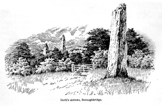
Devil’s Arrows (Percy Robinson, c.1895)
To many archaeo-megalithic and folklore fans, these huge standing stones need no introduction. These great heathen Arrows of the devil, today at least, are three gigantic standing stones, each one weighing several tons at least, standing in a rough straight line, nearly north-south. This is the greatest single stone-row anywhere in the British Isles.
Just how many standing stones originally stood here is difficult to say. We know from the records of early antiquarians and travellers that we had at least five Arrows here in centuries gone by; but one curious account, mentioned by the Yorkshire antiquarian Edmund Bogg (1895) more than a hundred years ago told:
“Peter Franck, a fisherman who travelled much about the world to enjoy his sport, came to Boroughbridge in 1694 and says he saw seven of these standing stones, Dr Stukeley mentions five, and John Leyland, in his travels, saw ‘four great stones wrought by man’s hands,’ but no inscription upon them. Camden, in 1592, saw four, but one of them at the time was thrown down, ‘for,’ says he, ‘the accursed love of gain.’ Part of this one is still to be seen, built into the Peggy Bridge which crosses the Tut on the entrance to the town, the top portion being preserved in the grounds of Aldborough Manor and this goes far to prove — and I have very carefully considered the question and examined the ground — that the original number of stones was far greater, and reached from the Yore, in equal distances to the Tudland of Leyland’s time, or the Staveley Beck of today. If this argument is correct, 2000 years ago there would be a line of at least 12 standing monoliths guarding the western approach to Isur Brigantium.”
John Aubrey’s 1687 plan Devil Arrows Stone CircleWill Stukeley’s 1776 image
Well y’ never know! But who was this Peter Franck chap from the 17th century? It would be good to find out more of what he said.
But this notion of there being a great many more stones here than the four or five that are accepted as standard, isn’t just to be found in the annals of some lost fisherman. The great Royalist antiquarian John Aubrey came here in September 1687 and, as illustrated here, saw the remaining three upright stones as remnants of a concentric ring of stones of obviously gigantic proportions. Following from a rough survey of the site and descriptions from local people, Aubrey placed the standing stones in their old line, of
“A. B. C. D., and I have drawn two imaginary circles in which it may be supposed that stones were placed, as at Avebury, Stonehenge, etc. Perhaps they might be more stones in each circle than I have fancied.”
Nearly two hundred years later, archaeologist John Ackerman (1847) echoed John Aubrey’s notion (or perhaps simply copied them) in his notion of the Devil’s Arrows once being part of a greater megalithic complex, saying,
“At Rudston and Boroughbridge, in Yorkshire, are supposed examples of maenhirs. Near the latter place there are four standing in a row, which are called by the country people the Devil’s Bolts; but, from their relative position, it is not unlikely that they are the remains of a large circle.”
Devil’s Arrows (from Smith’s ‘Reliquiae’)The top 2 Arrows
As if to tempt further enquiry, or at least require suitable explanation, is the nearby field-name of ‘Kringelker,’ or Cringles Carr — last described in 1316 — and which means very simply a circle by the marsh, or circular marsh, or variants thereof. (Source: Yorkshire Deeds, volume 4,YAS: Leeds 1904)
But prior to John Aubrey’s speculations on the Arrows being part of a giant ring of stones, he related the earliest survey done here, by a local (unnamed) man on April 17, 1669, telling that:
John Aubrey’s 1687 sketch of the Arrows
“In Yorkshire near Burrough-brig on the west side of the Fosse-way, about a quarter of a mile, (in the Lordship of Alburgh) stand three pyramidish stones called the Devills Arrowes. The Arrow standing towards the south is seven yards and a half in height: the compasse of it five yards and a half. The middle Arrow seven yards and a half, in compass six yards. The Arrow towards the north in height five yards and a half, in compass seven yards. Here was another stone that stood in a straight line, at D, that was taken down and a bridge made of it.”
Other regal antiquarians and learned writers of the period came soon after. When William Camden (1695) visited the place at the end of the 16th century, he was equally impressed and described the place as follows:
“Not farre beneath there standeth by Ure a little towne called Burrowbridge, of the bridge that is made over the river: which is now built very high and faire of stone worke, but in King Edward the Second his time it seemeth to have beene of wood. For wee read that when the Nobles of England disquieted this king and troubled the state, Humfrey Bohun Earle of Hereford in his going over it was at a chinke thereof thrust through the body about his groine by a souldiour lying close under the bridge. Neere unto this bridge Westward wee saw in three divers little fields foure huge stones of pyramidall forme, but very rudely wrought, set as it were in a streight and direct line. The two Pyramides in the middest, whereof the one was lately pulled downe by some that hoped, though in vaine, to finde treasure, did almost touch one another. The uttermore stand not far off, yet almost in equall distance from these on both sides. Of these I have nothing else to say but that I am of opinion with some that they were monuments of victorie erected by the Romans hard by the high street that went this way. For I willingly overpasse the fables of the common people, who call them the Devills Bolts, which they shot at ancient cities and therewith overthrew them. Yet will not I passe over this, that very many, and those learned men, thinke they are not made of naturall stone in deed, but compounded of pure sand, lime, vitriol (whereof also they say there bee certaine small graines within), and some unctuous matter. Of such a kinde there were Rome cisterns, so firmely compact of very strong lime and sand, as Pliny writeth, that they seemed to be naturall stones.”
Another early antiquary, John Leland, also passed by here a few hundred years back and wrote the following after his visit:
“A little without this Towne on the west part of Watiling-Streate stadith 4 great maine stones wrought above in conum by Mannes hand. They be set in 3 several Feldes at this Tyme. The first is a 20 foote by estimation in higeth and an 18 foote in cumpace. The stone towards the ground is sumwhat square, and so up to the midle, and then wrought with certen rude boltells in conum. But the very toppe thereof is broken of a 3 or 4 footes. Other 2 of like shap stand in another feld a good But shot of: and the one of them is bigger then the other; and they stand within a 6 or 8 fote one of the other. The fourth standith in a several feld a good stone cast from the other, and is bigger and higher than any of the other 3. I esteme it to the waite of a 5 Waine Lodes or more.
Inscription could I none find yn these stones; and if there were it might be woren out; for they be sore woren and scalid with wether.
I take to be a trophaea a Romanis posita in the side of Watheling Streat, as yn a place most occupied in Yorneying ad so most yn sighte.”
Possible cup-marks on northernmost Arrow
Rock Art on the Devil’s Arrows
Although Leland told us he could find no inscriptions on the stones, he missed some which may be much older than the purely Roman marks his nose was seeking. Cup-and-ring stones — much in vogue nowadays thanks to the new, shamanically-inspired archaeo’s — aren’t etched here in anything like the styles expected of our Swastika Stone, or the Achnabreck carvings, but cup-markings seem to occur on the northernmost stone. Although a rather myopic bunch of earth-mystery people thought they were the first to discovered the cup-markings here in 2005, they were in fact first described way back in 1866, in Sir James Simpson’s precursory essay to his Archaic Sculpturings (1867), where he told:
“In England the most striking and magnificent group of monoliths that I have seen are the so called Devil’s Arrows at Borough-Bridge, in Yorkshire. Three only of these tall and enormous monoliths are now left, and stand in a line about a stone’s throw from each other. They are all pillars of a squarish shape, and said to bo formed of millstone grit. Two of them are above twenty-two feet in height, and the third measures eighteen feet. Each at its upper part is deeply and vertically guttered, apparently by long weathering and exposure ; and their lower portions show round, smooth, cup-like excavations upon some of their surfaces. The most northerly of these imposing monoliths is especially marked in this last way. Many, if not all, of these excavations, have probably been effected by the elements and weather; while some of them, which look more artificial, are of the same shape and form as those on the Kilmartin stones, etc. But unfortunately we have not here the presence of rings or circles around the cups to determine conclusively their artificial character.”
The central Arrow
Some of the cup-markings here are distinctly artificial; but as with these ancient non-linear designs in general, we are unable to ascertain any specific ‘meaning’ to them at this site, even in any mythic sense — as yet! (I’ll get some images of cup-markings next time I visit the Arrows, unless someone has some going spare!)
Folklore
Described by Bob Mortimer (1860) as a gathering place of the druids, who “met here to celebrate their great quarternal sacrifice”; not unsurprisingly there are a variety of other fascinating creation myths and folklore motifs raising their usual heads by these great stones. Mortimer told of more tales following his local society’s visit here at the end of the 1850s, saying:
“There lived a very pious old man (a Druid should we imagine) who was reckoned an excellent cultivator of the soil. However, during each season at the time his crops had come to maturity they were woefully pillaged by his surrounding neighbours; so that at this, he being provokingly grieved, the Devil appeared, telling the old man if he would only recant and throw away his holiness he should never more be disturbed in his mind, or have whatever he grew stolen or demolished. The old man, like Eve in the garden, yielded to temptation, and at once obeyed the impulse of Satan for the benefit of worldly gain. So when the old man’s crops were again being pillaged, the Devil threw from the infernal regions some ponderous arrows, which so frightened the plunderers by shaking the earth that never more was he harrassed in that way. Hence the name of the ‘Devil’s Arrows.'”
Another individual told me that it was believed by some that the stones sprung up one night in the very places they now occupy.”
Very close to the Arrows are antiquarian records of other sites which someone can hopefully throw more light on, as they may have had some relationship with the stones. Immediately west were (are?) the Penny Stones; plus a place called Bell’s Wife’s Field (Bel as a sun-god – though his wife may imply the moon). And just a few hundred yards east is the old Lady Well, mentioned elsewhere.
…to be continued…
References:
Ackerman, John Yonge, An Archaeological Index to the Remains of Antiquity of the Celtic, Romano-British and Anglo-Saxon Periods, J.R. Smith: London 1847.
The Stranger’s Guide; Being a Concise History & Description of Boroughbridge, John Mitchell: Boroughbridge 1846.
Bennett, Paul, The Devils Arrows, Heathen Earth: Keighley 2009.
Bogg, Edmund, From Eden Vale to the Plains of York, Goodall & Suddick: Leeds n.d. (c.1895)
Bogg, E., Richmondshire and the Vale of Mowbray (volume 1), Elliott Stock: London 1906.
Brayshaw,Thomas, ‘The Yorkshire Portions of Leland’s Itinerary,’ in YAJ 10, 1889.
Burl, Aubrey, ‘The Devil’s Arrows,’ in YAJ 63, 1991.
Burl, Aubrey, From Carnac to Callanish, Yale: New Haven & London 1993.
Camden, William, Britannia, or a Chorographical Description of Great Britain and Ireland, Edmund Gibson: London 1695.
Devereux, Paul & Thomson, Ian, The Ley Hunter’s Companion, Thames & Hudson: London 1979.
Elgee, F. & H.W., The Archaeology of Yorkshire, Methuen: London 1933.
Forrest, Bob & Behrend, Michael, ‘The Devil’s Arrows on Target,’ in The Ley Hunter,no.107, 1989.
Lawson-Tancred, Lady, A Guide Book to the Antiquities of Aldborough and Boroughbridge, J. Topham: Boroughbridge 1948.
Leadman, A.D.H., ‘The Devil’s Arrows,’ in The Antiquary, 1903.
Leland, J.J., The Itinerary of John Leland the Antiquary, Fletcher & Pote: Oxford 1770.
Lewis, A.L., ‘The Devil’s Arrows, Yorkshire,’ in Journal. Anthr. Institute, 8, 1878.
Longworth, Ian H., Regional Archaeologies: Yorkshire, Cory, Adams & Mackay: London 1965.
Lukis, W.C., ‘The Devil’s Arrows,’ in Proc. Soc. Antiquaries London, volume 7, 1877.
Lukis, W.C. (ed.), The Family Memoirs of the Rev. William Stukeley – volume 3, Surtees Society: Durham 1887.
Mee, Arthur, Yorkshire, West Riding, Hodder & Stoughton: London 1941.
Mortimer, Robert, ‘The Great Monoliths at Boroughbridge,’ in The Geologist journal, London 1860.
Phillips, Guy Ragland, Brigantia, RKP: London 1976.
Radley, J., ‘Prehistory of the Vale of York,’ in YAJ 1974.
Ross, Frederick, Legendary Yorkshire, William Andrews: Hull 1892.
Simpson, James Y., Archaic Sculpturings of Cups, Circles, etc., upon Stones and Rocks in Scotland, England and Other Countries, Edmonston and Douglas: Oxford 1867.
Smith, A.H., Place-Names of the West Riding of Yorkshire (volume 5), EPNS: Cambridge 1963.
Smith, Henry E., Reliquiae Isurianae, J.R. Smith: London 1852.
Somerville, Boyle, The Devil’s Arrows: Prehistoric Stone Monuments and their Orientation, B.A. Handbook, 1927.
Stukeley, William, Itinerarium Curiosum (volume 2), London 1776.
Thom, A.S. & Burl, Aubrey, Stone Rows and Standing Stones, BAR: Oxford 1990.
Turner, T.S., History of Aldborough and Boroughbridge, Arthur Hall: London 1853.
Tutin, John, ‘Theory about the Three Arrows,’ Yorkshire Life 3, 1954.
Walford, John. ‘An early description of the Devil’s Arrows, Boroughbridge, North Yorkshire,’ in Yorkshire Archaeological Journal, 79, 2007.
Wood, E.S., ‘The Grooves on the Devil’s Arrows, Boroughbridge,’ PPS 13, 1947.
Many ways to get here, but the easiest for those with cars to is park up on the southeast edge of the hill, at the various scruffy parking bits beside the road at the Nick of Pendle. The view from here is enough to get you going! Walk onto the great hill up to the rounded pap of Apronfull Hill (rather gives it away really!). It’s only a few hundred yards up – about 10 mins up the slope from the road, with awesome views all round once you get there. Tis the small guidance cairn you’re looking at just on the level. You’re there!
Archaeology & History
This would once have been a rather huge cairn/tomb — though when I first found the remains of this place in August 2006, there were no archaeological records describing it that I could find. But there’s very little left of it. The lads who did the quarrying further downhill (where you’ve probably parked your car) are likely to have been the culprits who nicked most of the rocks that once made this huge forgotten tomb. But as you potter about here, it becomes obvious that you’re standing on the much-denuded remains of just such a monument (very similar in size and structure to the more famous Little Skirtful and Great Skirtful of Stones on Burley Moor, or Black Hill round cairn near Skipton). But the remains you can see beneath your feet still give a good idea as to how large it was.
Remnants of the cairn-spoil cover the ground where the monument once stood proud!
You’ll see once you’re stood here that there are hundreds, maybe even several thousands of stones just on and below the ground, scattering a very well-defined roughly circular area measuring at least 21 yards (east-west) by 22 yards (north-south), right by the side of the path. The edges of this ransacked cairn are pretty well defined around the north and eastern sides. Near the centre of the old structure is a very notable ‘dip’ in the ground where it looks as if something has been dug away — though this could just as well be due to the presence of underground water, as indicated by the growth of Juncus grasses. Without an excavation it’s obviously difficult to tell.
Folklore
Twas the following tale which first led my nose to explore this part of Pendle hill. It’s a tale we find at many of our upland tombs, though the record books said there was nowt here! (any myopic archaeologists out there who reckon that folklore has no relevance to their subject, educate one’s self!)
Looking from the Devil’s Apronful towards Jeppe Knave’s Grave
The Devil was having trouble with the folk at Clitheroe Castle (a few miles west) and wanted rid of it. So he picked up various large stones and put them in his apron then threw them towards the castle. Most of them missed, which made him angry and in a rage he accidentally dropped a great pile of rocks on the south side of Pendle Hill, creating the Devil’s Apronful on Apronfull Hill.
In another tale he was said to have stood at the Deer Stones a few hundred yards east of here and threw rocks from there. Perhaps a folk-remnant of where the Apronful stones once came from…? Perhaps not.
Jessica Lofthouse (1976) notes how this old spot was long known by local people as the Devil’s Apronful.
References:
Lofthouse, Jessica, North-Country Folklore, Hale: London 1976.
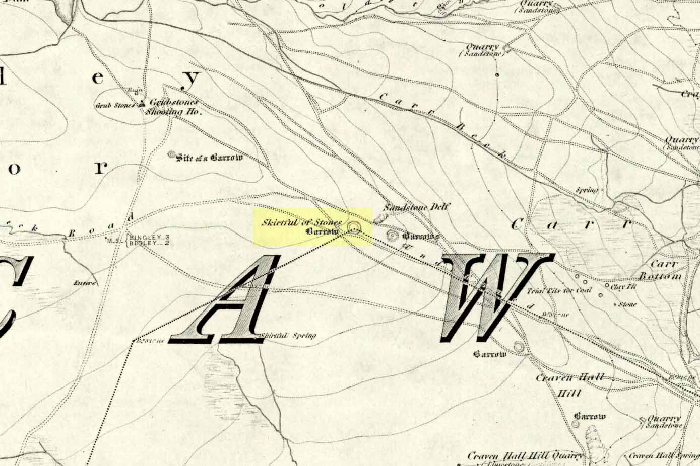
Various routes to this giant tomb, which happens to be a way off the roads (thankfully!). Probably the easiest way is from the Menston-side: up Moor Lane, turn left at the end, go 200 yards and take the track onto the moor. Just keep walking. If you hit the rock-outcrop nearly a mile on, you’ve gone past your target. Turn back for about 400 yards and walk (south) into the heather. You’re damn close!
Archaeology & History
Great Skirtful of Stones cairn looking east to Otley Chevin
Due north of the Skirtful Spring water source, this is one of Ilkley Moor’s major prehistoric sites: ‘major’ for a number of reasons – not least of which is the size of the thing! Although getting somewhat overgrown these days as more of the heathlands encroach the mass of rocks that constitute the central ‘tomb’, it is still a formidable heap. Another reason this site is of importance is its position in the landscape: it can be seen as the peak or ‘nipple’ on the landscape from considerable distances north, south and east of here, rising up on the horizon and catching the eye from many miles away. This was obviously quite a deliberate function of the site when it was first constructed – thought to be in the Bronze or Iron Age period (sadly we have no decent excavation here to tell us just when it was made). Another reason for its importance is its position relative to a once huge prehistoric graveyard immediately east. And right next to it we also find a curious circular monument that has never been properly excavated, whose function is unknown. It is also the seeming focal point of at least one, though possibly three prehistoric trackways: one of which goes right past it, though swerves on its southern edge quite deliberately so as to not touch the monument. This trackway appears to have been a ceremonial ‘road of the dead,’ along which our ancestors were carried, resting for some reason at the nearby Roms Law, or Grubstones Circle, a few hundred yards to the west.
Wrongly ascribed as a “round barrow” by archaeologist Tim Darvill (1988), the Great Skirtful cairn was named in boundary changes made in 1733, where one Richard Barret of Hawksworth told that the site was “never heard go by any other name than Skirtfull of Stones.”
In 1901 there was an article in the local ‘Shipley Express‘ newspaper — and repeated in Mr Laurence’s (1991) fine History of Menston and Hawksworth — which gave the following details:
“Mr Turner led the way across Burley Moor to the Great Skirtful of Stones, a huge cairn of small boulders, nearly a hundred tons on a heap, although for centuries loads have been taken away to mend the trackways across the moor… The centre of the cairn is now hollow, as it was explored many years ago, and from the middle human bones were taken and submitted to Canon Greenwell and other archaeologists” – though I have found little in Greenwell’s works that adequately describe the finds here. Near the centre of the giant cairn is a large stone, of more recent centuries, which once stood upright and upon which is etched the words, “This is Rumbles Law.” The Shipley Express article goes on: “Mr Turner explained that ‘law’ was always used in the British sense for a hill, and Rumbles Hill, or cairn, was a conspicuous boundary mark for many centuries. He had found in the Burley Manor Rolls, two centuries back, that on Rogation Day, when the boundaries were beaten by the inhabitants, they met on this hill, and describing their boundaries, they concluded the nominy by joining in the words, “This is Rumbles Law.””
Great Skirtful on 1851 map
Several other giant cairns like this used to be visible on the moors, but over the years poor archaeological management has led to their gradual decline (and in editing this site profile in 2016, have to report that poor archaeological and moorland management is eating into and gradually diminishing this monument to this day). We still have the Great Skirtful’s little brother, the Little Skirtful of Stones, a half-mile north of here. The very depleted remains of the once-huge Nixon’s Station giant cairn can still be seen (just!) at the very top of Ilkley Moor 1½ miles (2.65km) west.* And we have the pairing of the giant round cairn and long cairn a few miles west on Bradley Moor, near Skipton. The tradition of such giant tombs on these hills was obviously an important one to our ancestors.
Folklore
We find a curious entry in the diaries of the Leeds historian Ralph Thoresby, in the year 1702, which seems to describe the Great Skirtful of Stones, adding a rather odd bit of folklore. (if it isn’t the Great Skirtful, we’re at a loss to account for the place described.) Mr Thoresby told how he and Sir Walter Hawksworth went for a walk on Hawksworth’s land and said how,
“he showed us a monumental heap of stones, in memory of three Scotch boys slain there by lightning, in his grandfather’s, Sir Richard Hawksworth’s time, as an old man attested to Sir Walter, who being then twelve years of age helped to lead the stones.”
As far as I’m aware, this old story of the three Scottish boys is described nowhere else.
Like many giant cairns, the Great Skirtful has a familiar creation myth to account for its appearance. In one version we hear that it was made when the local giant, Rombald (who lived on this moor) and his un-named wife were quarrelling and she dropped a few stones she was carrying in her apron. A variation swaps Rombald’s wife with the devil, who also, carelessly, let the mass of stones drop from his own apron to create the ancient cairn we still see today.
According to Jessica Lofthouse’s North Country Folklore (1976), a Norse giant by the name of Rawmr, “fell fighting against the Britons of Elmet and is buried, they say, on Hawksworth Moor” – i.e., the southeastern section of Rombald’s Moor, very probably at the Great Skirtful of Stones. I’ve yet to explore the history and etymology of the name Rawmr…
References:
Bennett, Paul, The Old Stones of Elmet, Capall Bann: Chieveley 2001.
Cowling, Eric T., Rombald’s Way, William Walker: Otley 1946.
Darvill, Timothy, Ancient Britain, AA: Basingstoke 1988.
Laurence, Alastair, A History of Menston and Hawksworth, Smith Settle: Otley 1991.
* Whoever is/was supposed to be responsible for the care of the Nixon’s Station giant cairn monument should be taken to task as it’s been virtually obliterated since when I first came here 30 years ago. Which useless local archaeologist and/or council official is responsible for its destruction? Who allowed it to happen? Why are Ilkley Moor’s prehistoric monument’s being so badly looked after by those who are paid to ensure their maintenance? Are their heads up their arses, in the sand, or—don’t tell me—the prawn sandwiches are to blame!?
From Kilburn village, take the north road up past the church for about 300 yards, bearing up the track on your left and walk up into the wooded hill a mile ahead of you. It’s in there!
Folklore
In this region there’s a teeming cluster of druid, fairy, devil and spook-lore, along with numerous prehistoric remains. Not sure this site has such an archaic pedigree, though the creation myth told of this rock (marked on the 1st edition OS-map as an antiquity) seems to imply as such. Our old devil disguised himself as a druid many moons ago in an attempt to gain favour with the old priests, but was discovered in his plans and so, in anger, flew out across the hills carrying a great stone with him which he dropped from the skies and it landed where the Hood Hill Stone still remains. Also in anger he jumped down and stood on the great rock, and in doing so left his footprint impressed upon the stone. (There’s the possibility this is an unrecognised cup-marking – having not been here I can’t say misself). Edmund Bogg (1906) also tells us that,
“The monk’s hood-like configuration of the crest is said to have originated its name. The busy tongue of tradition, however, says that the name commemorated Robin Hood who, with his merry men, affected the hill-fastnesses hereabouts; but the hill was named ‘Hode’ long, long before the famous Robin came this way at all.”
The same writer also told how,
“legend, too, has it that the happy valley just north of Hood Hill…was a secluded and sacred retreat of the druids, and at the introduction of christianity into these parts, a great assembly gathered to consider which of the two religions should in future be adopted.”
Yet another legend – and an old one, says Bogg – is “that when the dinner-bell rang at Osgodby Hall the stone rolled down for its repast, and regularly returned to the crest after the meal.”
It’s blatantly obvious that something of antiquity this way hides. The “enclosure” shown on the modern OS-maps here could do with being looked at little closer.
References:
Bogg, Edmund, Richmondshire and the Vale of Mowbray (volume 1), James Miles: Leeds 1906.


sm")