About 1 mile west of where the B8034 meets the A81, between the Port of Menteith and Aberfoyle, a small road on the right (north) at Portend takes you up the single-track road to Upper Glenny. Go 2-300 yards up past Mondowie Farm and take the next track, left. Walk up through the gate for nearly 300 yards, going through the gate on your left and onto the fields. Follow the fence for 300 yards then go through the gate into the next field—past one of the Nether Glenny cairns—and walk across it until you reach an open gate at the far side, just where the hillside goes up. It’s nearly under your feet!
Archaeology & History
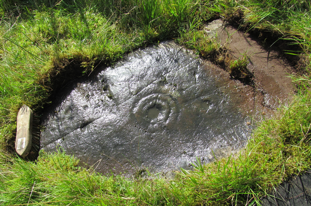
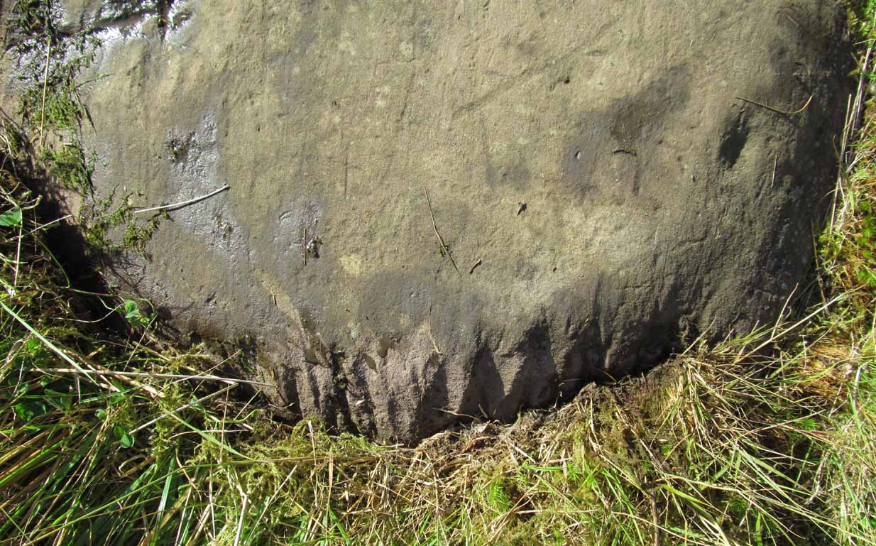
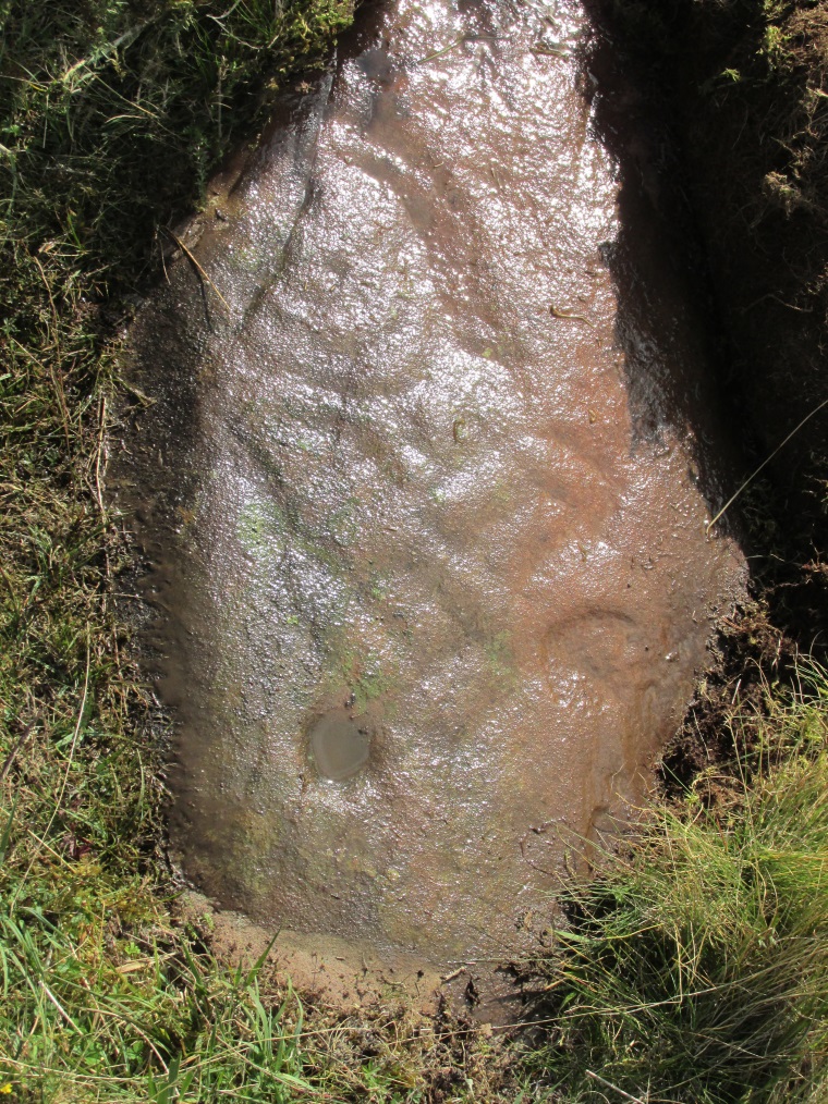
Close-up of the cup&ring
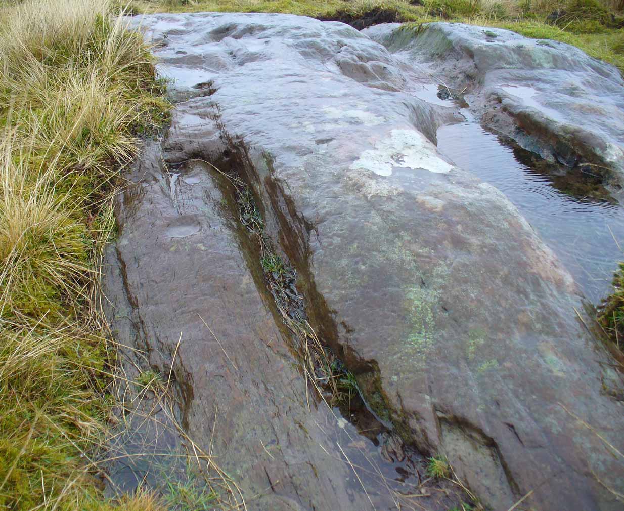
This single cup-and-ring carving, found amidst the massive cluster of both simple and highly complex petroglyphs between Ballochraggan and Upper Glenny, doesn’t seem to have been included in any previous surveys. It was located during the incredible rains yesterday on Sunday 7 February, wetting this and other rocks, enabling better visibility of otherwise invisible symbols faintly remaining here and on other stones. The carving appears to have been etched into naturally occurring notches and fissures. Certainly worth looking at when exploring the other incredible carvings on this hillside.
Take the same directions as if you’re visiting the nearby Nether Glenny 2 cairn. Once here, walk less than 100 yards further down into the same field, north, roughly parallel with the fencing. You’ll reach several large rocks, and the elongated one on the slight rise closer to the fence is the one you’re after. You’ll find it!
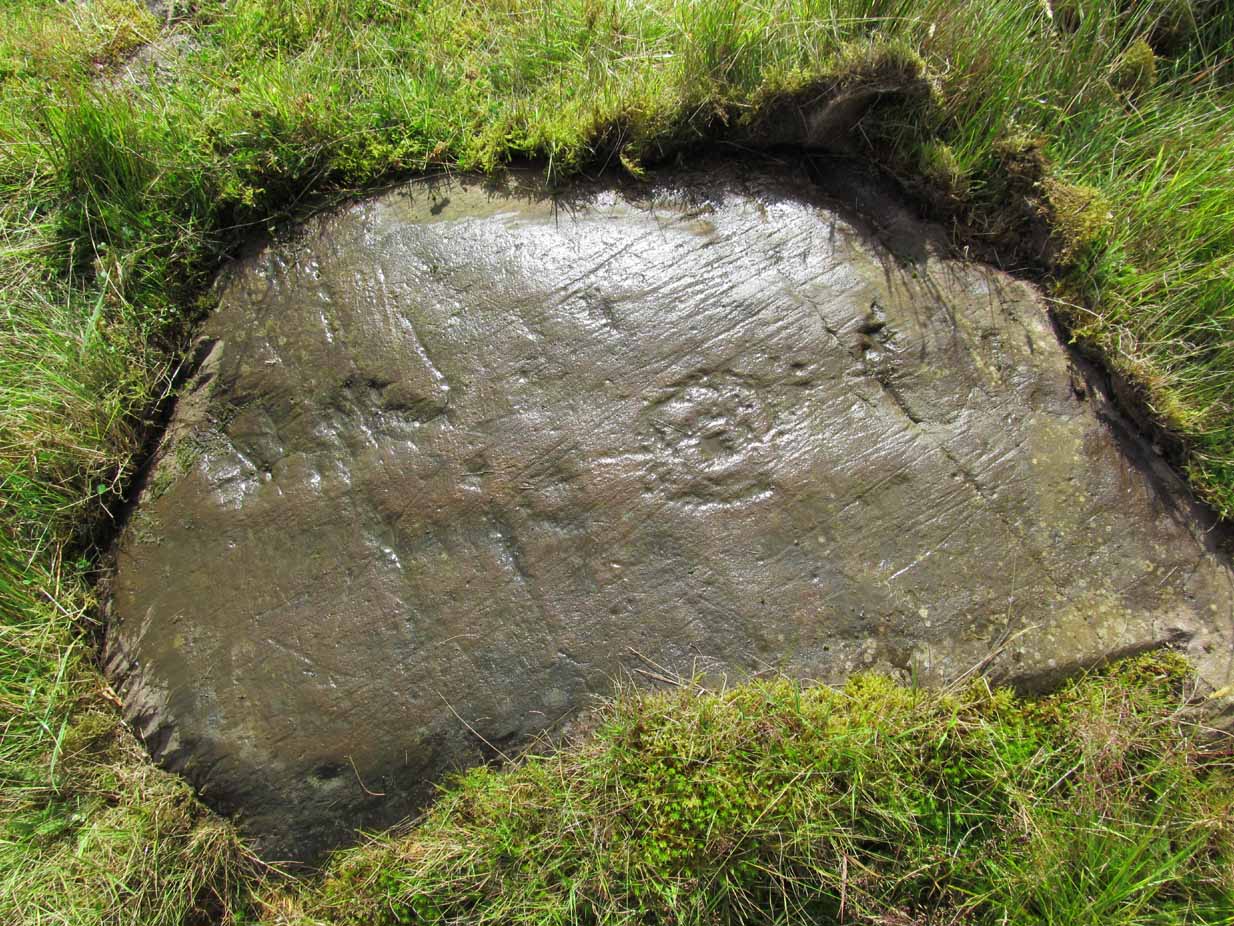
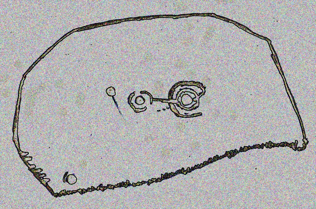
This is one in a number of impressive cup-and-ring stones scattered along this grassy ridge overlooking the Lake of Menteith and the Gargunnock Hills to the south. Petroglyph lovers amongst you will love it! And it seems that with each and every analysis, the carvings gives up more and more of its ancient symbolism. When it was first described (in a literary sense) by Maarten van Hoek (1989) he told it to be:
“Irregular outcrop with at least 72 single cups; 3 cups with 2 rings; 6 cups with 1 ring and 2 possible horse-shoe rings only.”
But when Kaledon Naddair (1992) visited the site a few years later he amended this initial description, telling us how,
“Further temporary turf removal extended the total to 124 solo cups, and 9 cups with 1 ring, and 5 cups with 2 rings.”
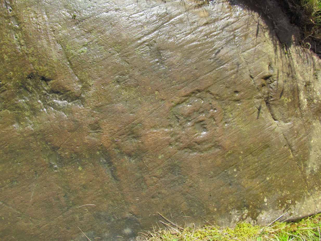
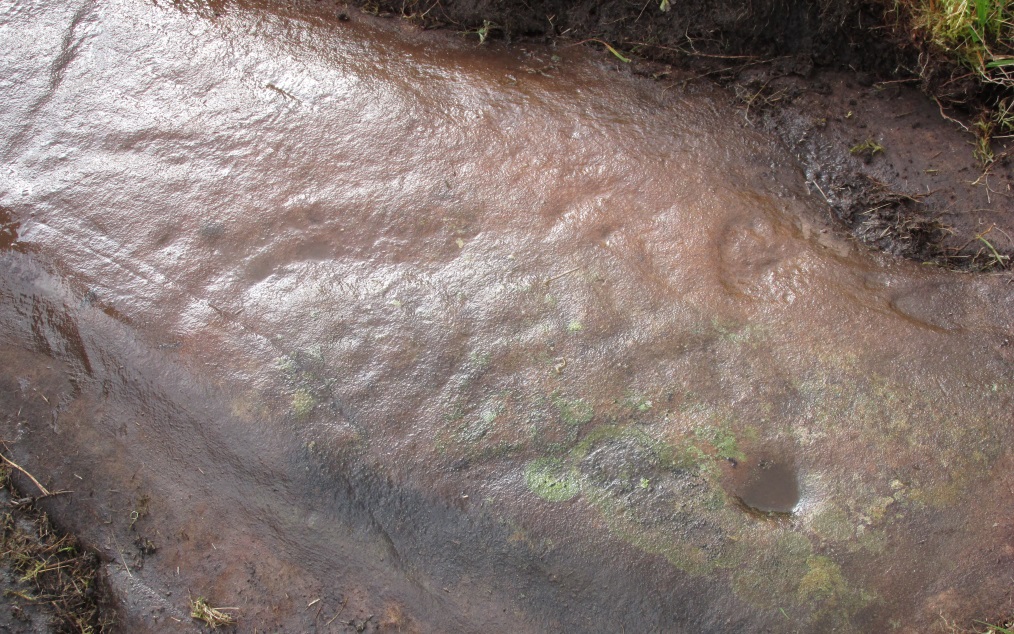
Cups & rings & cups….Western side of carving
Naddair’s description is closer to our own inspection, although I think that a small number of the ‘cups’ are natural. Other features that we’ve found occur on the more western side of the rock. A faint partial-double-ringed cup is accompanied a few inches away by a carved element that seems to have been unfinished. An initially indistinct circle, faintly pecked, has internal lines at the quadrants, akin to an early cross form. A line emerges from this symbol which also seems to have been slightly worked.
Subsequent investigations of this carving has uncovered much more which, to be honest, requires almost an entire re-write of this profile……
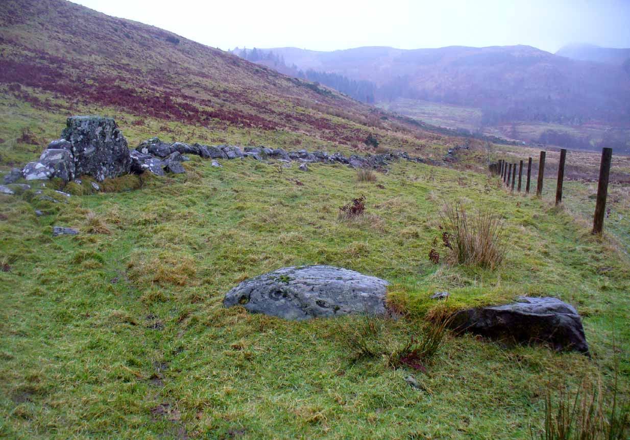
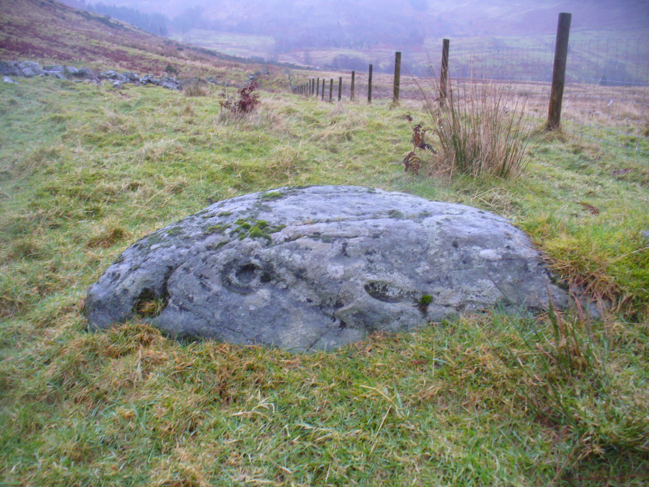
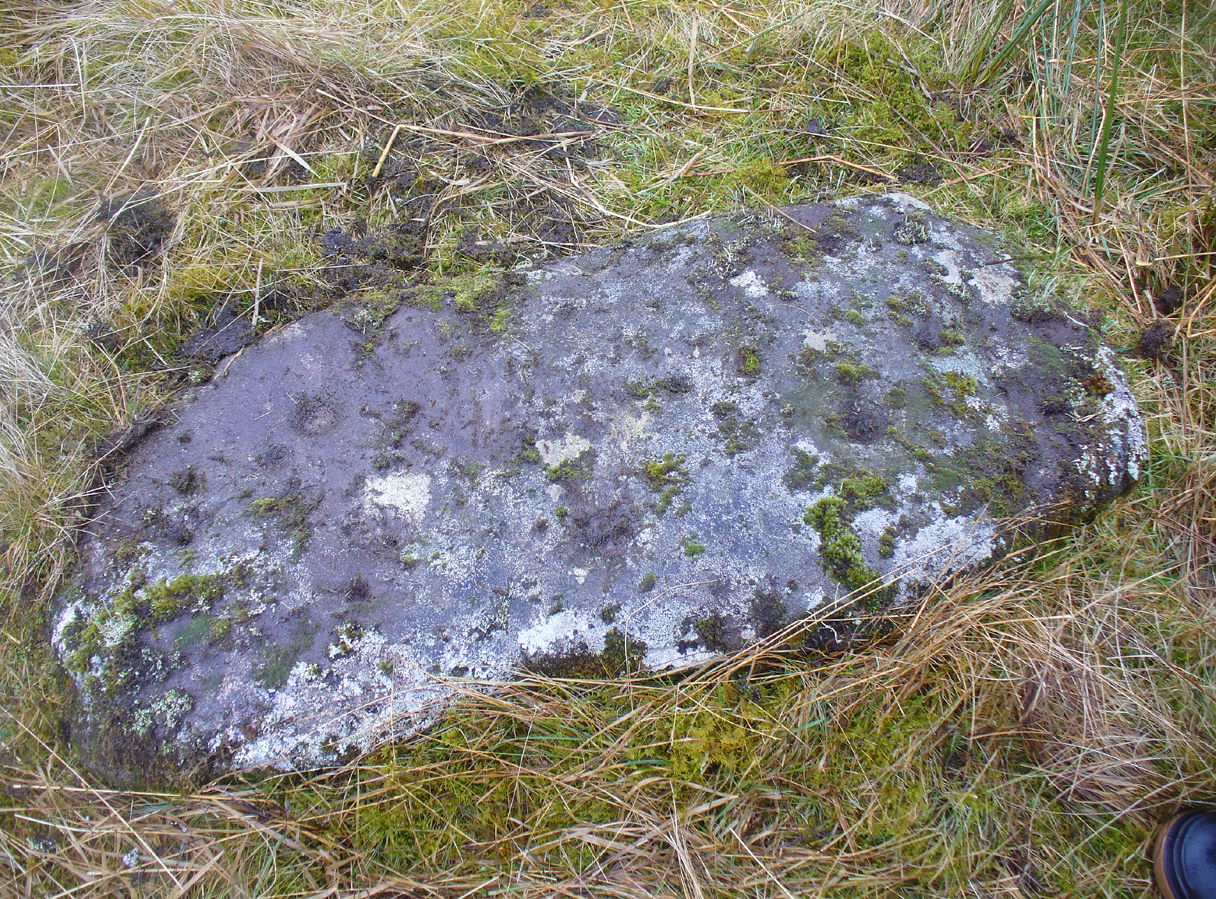
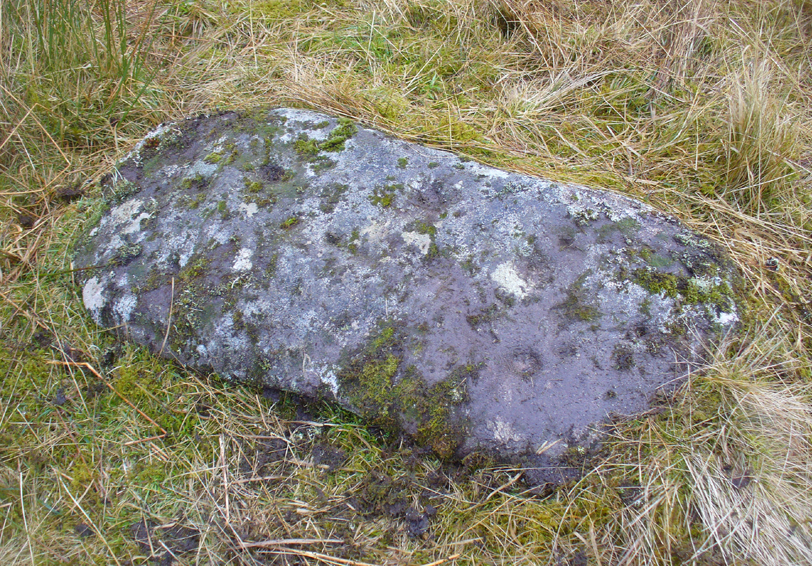
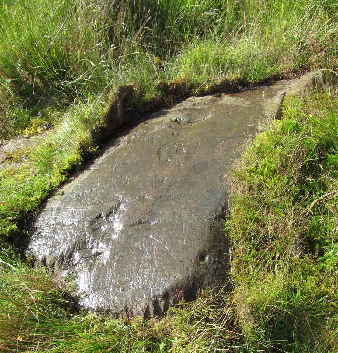
Take the same directions to reach the Nether Glenny cairn (about 1 mile west of where the B8034 meets the A81, between the Port of Menteith and Aberfoyle, up a small road on the right [north] at Portend) and walk to its companion cairn 100 yards north. From here, walk west across the field towards the nearby forest. Nearly 20 yards from the wall and about 35 yards from the corner of the field where it meets the forest, this elongated stone lies amidst the grasses and reeds. You’ll find it.
Archaeology & History
…and from another angle
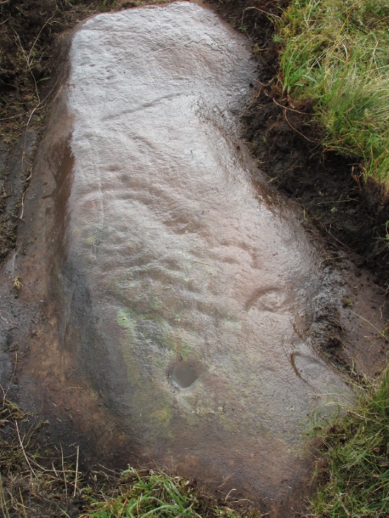
Looking somewhat like a small fallen standing stone (the Royal Commission list just such a stone nearly 200 yards east), this slim elongated rock was first described in Maarten van Hoek’s Menteith (1989) survey where he told it to be a “loose slab north of the…burn, bears at least thirteen cups.” But of the “thirteen cups”, only five of these (seven at the most) appear to be man-made. The others are, quite distinctly, geophysical in origin (and in all probability, the other cups were forged from the geological nicks and dimples). One of them may have the faint remains of a ring around it, but this is uncertain. When we visited the site yesterday, the light was poor and although this ‘ring’ seems to show up on a couple of photos, I’m erring on the side of caution.
van Hoek, Maarten, “Menteith (Port of Menteith parish) Rock Art Sites,” in Discovery & Excavation Scotland, 1989.
Acknowledgements: Huge thanks to Paul Hornby and Nina Harris for their help and endurance at this site, amidst healthy inclement Scottish February weather! Another damn good day!
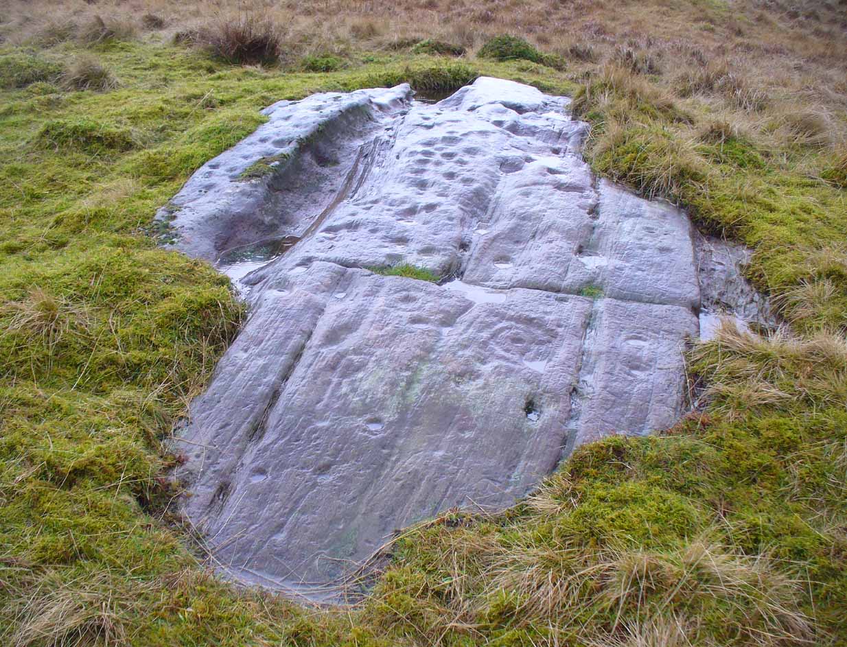
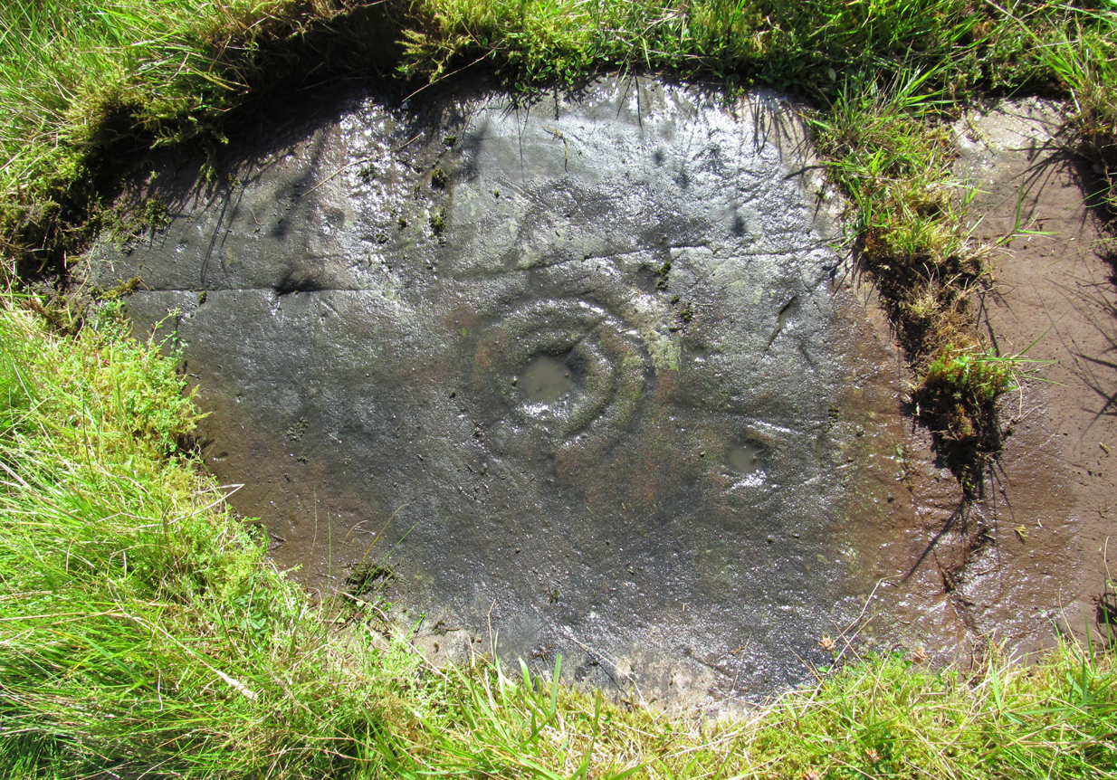
Along the A81 road from Port of Menteith to Aberfoyle, watch out for the small road in the trees running at an angle sharply uphill, nearly opposite Portend, up to Coldon and higher. Keep going, bearing right past Mondowie and stopping at the dirt-track 100 yards or so further up on the left. Walk up this dirt-track for ⅔ mile, and just before reaching the planted forestry, turn right along another dirt-track. Less than 200 yards along there’s a large sycamore tree, and about 20 yards below it (south) are several open flat rock surfaces. This is the most westerly of them.
Archaeology & History
…and again
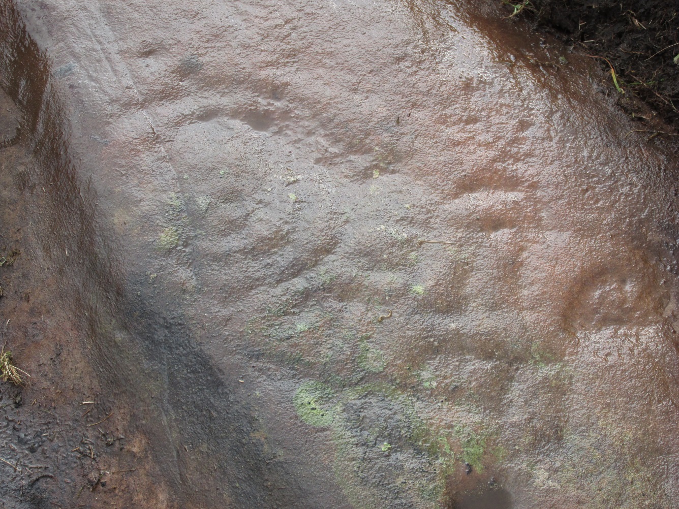
On this small smooth rock surface we find an almost archetypal cup-and-ring stone, whose design consists of a double cup-and-ring and a faint cup-and-ring. The double-ring has several seemingly natural small fissures in the rock running at various angles into the central cup from the outside; and there are two faint ones running from the double-rings outwards to the cup-mark in the single-ring, framing the central cupmark in the middle. It may have been that these scratches on the rock gave rise to the position of the cupmark in this petroglyph. It’s difficult to see whether or not the single cup-and-ring was ever completed.
Canmore’s description of this petroglyph tells simply: “The larger of the two is 180mm in diameter and has two rings around a cup that is 70mm in diameter and 15mm deep. The smaller has one ring around a cup.”
Once you’ve seen this, have a look at the Over Glenny (6) carving, about 10 yards east of here.
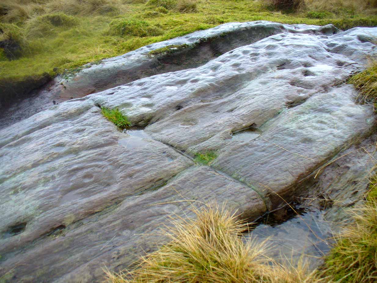
Along the A81 road from Port of Menteith to Aberfoyle, watch out for the small road in the trees running at an angle sharply uphill, nearly opposite Portend, up to Coldon and higher. Keep going, bearing right past Mondowie and stopping at the dirt-track 100 yards or so further up on the left (and ignore the english fuckers up here who might say “you’re not allowed to park here”, as Scottish government regulation allows you to do so unless you block the road). Walk up this dirt-track for ⅔ mile, and just before reaching the planted forestry, turn right along another dirt-track. Less than 200 yards along there’s a large sycamore tree, and about 20 yards below it (south) is the carving you’re looking for.
Archaeology & History
It’s difficult keeping up with the carvings in this region to the north of the Lake of Menteith, as we find new unrecorded ones on every visit, maintaining the tradition of fellow rock art students Maarten van Hoek, Kaledon Naddair, George Currie, Jan Broewer and the rest—and we know that there’s more of them hidden away. This one doesn’t seem to be in the Canmore listings, but I put that down to the fact that they’ve got a grid-reference wrong somewhere, as it’s pretty plain to see. Although, to be honest, in the rather vague descriptions of other adjacent carvings (Over Glenny 5 and 7), this carving is in-between them, so you’d expect it to be listed. Anyway, that aside…
Looking down at the ringsClose-up of faint rings
This long flat exposed rock surface has two primary cup-and-rings upon it: one cup with a double-ring, and the other standard cup-and-ring; there are also two single cup-markings on the stone: one near the middle of the rock and the other on its lower-right side. The main element is the double-cup-and-ring, which appears to be incomplete—not only in terms of its design, but also, as you can see in the photos, seems unfinished. From the central double-ring, a faint carved line runs out from the centre and into the other faint, incomplete, single cup-and-ring.
Series of metal-sharpening groovesArty-farty sketch of the design
At the bottom of the stone (as with several others hereby) a curious set of deep scars have been cut into the edge of the rock. They’re unmistakable when you see them. They have probably been created by metal artifacts being sharpened along the bottom of the rock—many many times by the look of it. These deep cuts reminded me of the more famous Polisher Stone, down Avebury-way. They may be explained by the fact that, several centuries ago, a battle occurred here and some of the men gathered in the area before the attack. It would seem as if this and the other cup-and-ring stones were used to sharpen their blades before going into battle. Whether this was done because of some local lore which imbued these stones with some sort of magick, we do not know. Folklore here seems curiously scarce (english incomers destroyed local traditions, as writers were telling us in the 19th century), apart from the well-known one of the area being rife with fairies: Robert Kirk’s famous The Secret Commonwealth of Elves, Fauns and Faeries (1691) was written three miles west of here, at Aberfoyle.
Take the same directions to locate the cup-and-ring stone of Ballochraggan 12. There are several rocks adjacent. The one immediately next to it, to the northeast, is the one you’re looking for. Be gentle and careful if you’re gonna look at it — deadly serious, be very careful indeed!
Archaeology & History
One of the most intriguing and most fascinating of all the prehistoric carvings I’ve yet to discover. Not that this was all my own work. If it hadn’t been for Paul Hornby, we might have simply walked past it as being little more than a single cup-marked stone—and in this area, single cup-marks tend to be little more than geological in nature.
After we’d looked over several of the registered carvings close by, I did my usual meandering back and forth, stroking stones and seeing if there were any carvings that had been missed by previous surveyors. And in walking past a small piece of smooth rock, a singular cupmark seemed to stand out. I walked past it, shouting across to my colleague.
“It looks like we’ve got a single cup-mark here Paul,” I said, “with possible half-ring.” Thankfully Mr Hornby gave it his better attention.
Mask Stone, with faint ‘urn’Close-up of features
The sun was still out and shining across the smooth rock surface, which tends to mean that you’re not seeing any carving on the stone quite as good as it actually is. Thankfully however, the sun was beginning to get lower and, when this happens, if we wet the rock, any carvings that might be there stand out much better. And this little fella just seemed to get better and more curious the more attention Paul gave it!
The first thing that became obvious were a series of faint carved lines above the single cup-mark. Initially these didn’t seem to merit much attention (straight lines on rock are usually more the product of geophysical action than that of humans), but as the rock got wetter, Paul saw something very distinct indeed.
“There’s a face on it!” he exclaimed. And indeed there was. A Rorschach response no doubt, but it was still very much like a face. This looked for all the world akin to the stylised olde English gentry sort of countenance, as in old cartoons. It was quite ‘distinct’, as such characters themselves insist on being! Yet around this initial face, more lines seemed to be emerging as the stone gave up more and more of its hidden story.
Standing back from an initial investigation, the carving was seen to consist of a triple-ring, but without the traditional ‘cup’ in its centre. Instead, the centre was marked simply by a small ‘dot’—perhaps, originally, being a small conglomerate hole formed as a result of another tiny harder fragment of stone falling away from its larger mass. But a ‘dot’ it was. The other carved ‘lines’ however, immediately below and attached to the triple-ring, gave us something almost unique—and another strong Rorschach response. As the photos clearly show, we have a distinct second ‘face’ made up of the same lines but in a quite different form. This ‘face’ has all the attributes we usually associate with pictures of mythical spirits, demons, or a mask—hence the name!
Paul took a series of fine photos, hoping that he could catch the image that our eyes could clearly see. And thankfully, his digital camera brought the image to life even better than our eyes did! The ‘mask’ is comprised of carved lozenge forms, akin to the more decorative ones we find at Kilmartin, and more especially around Newgrange, Ireland. We sat and talked about this: wondering and working out routes that we’d take over mountains and moors, from Ireland, to Kilmartin, then onto Ballochraggan, etching the same designs onto the rocks hereby and attaching similar mythic notions to them: of shamanism and kingship; underworlds and journeys—paradigms lost and certainly misunderstood in the non-polysemia of many modern academics.
Lozenges and rings
…The stone here was still slightly covered over and, beneath the loose grasses, another feature emerged of another petroglyphic rarity. At the topmost western side of the rock a straight line ran across the surface, seemingly marked by the hand of man, with a curious little line almost doubling back on itself for just an inch or so, and then feeling to run down the stone, towards the concentric rings and the face below. When we stood back and took the photos, this line and its tracer took on a form that I’ve only seen echoed in one of the Netherlargie tombs at Kilmartin, Argyll, 44.4 miles (73km) to the west. It is very distinct.
The beaker, rings & ‘face’
Spuriously ascribed as being ‘axe’ carvings (oh how archaeologists love this Rorschach projection), the Netherlargie North tomb cover-stone in Kilmartin has a series of burial ‘urns’ or beakers carved onto the rock, amidst a scattered collection of cup markings. (Beckensall 2005:73-4; Bradley 1983:92-3; Royal Commission 1971:68-70; Twohig 1972, etc) Here too at Ballochraggan we find another such symbol, but just a singular example, much larger and more clearly a beaker or urn, as are traditionally found within many old neolithic and Bronze Age tombs; although no tomb is immediately apparent at this Ballochraggan carving.
The entire carving is very faint indeed (you can’t even see it when you’re looking directly at it unless conditions are good) showing that it remained open to the elements for thousands of years. Other adjacent carvings lack the erosion that we find on this one, even on those which, as archaeologist Lisa Samson said, is “softer sandstone rock than this one”—implying that it’s one of the older carvings in this incredible cluster.
References:
Beckensall, Stan, The Prehistoric Rock Art of Kilmartin, Kilmartin Trust: Kilmartin 2005.
Bradley, Richard, Altering the Earth, Society of Antiquaries Scotland: Edinburgh 1993.
Royal Commission on the Ancient & Historical Monuments of Scotland, Argyll – volume 6: Mid-Argyll and Cowal, HMSO: Edinburgh 1971.
Twohig, Elizabeth Shee, The Megalithic Art of Western Europe, Clarendon: Oxford 1981.
Acknowledgments: Huge thanks again to Mr Paul Hornby for his considerable help with this site, and for use of his photos.
Take the same directions as if you’re visiting the Ballochraggan 12 carving, or nearby standing stone. Literally 10 yards above the leaning monolith, you’ll see what looks like a glacial rock drop ahead of you (though it’s actually volcanic). That’s the stone you want!
Archaeology & History
A site that was first described in Maarten von Hoek’s (1989) survey of the area, where he told this carving to be “a loose boulder (that) bears 14 cups, some possibly natural.” There is very little doubt about it—many of the ‘cups’ on this stone are indeed natural, caused directly by the erosion and subsequent falling of conglomerate rock nodules coming away from the larger rock mass, leaving holes in it that look like cup-marks, but are blatantly natural in origin.
Close-up of the cups – natural or man-made?
When Paul Hornby and I visited the site on August 28, 2014, we looked briefly at the stone and then walked on by—but we took some photos, “just in case the archaeo’s have this listed as a monument, ” I said. And they do! Several of the ‘cups’ shown in the images here might be man-made. Might…. It’s difficult to say for sure (are there any geologists in the house?) Of course, if the faint half-ring below one of these large ‘cups’ turns out to be legitimate, we’ve got a definite here. But even that looks a bit dodgy!
Despite these marks possibly being geophysical, we must not forget, nor rule out, that this rock had some importance to the neolithic or Bronze Age people who frequented this region. Natural marks on rock would be emulated by humans sometimes, or seen as elements of spirit in the stone itself—as found all over the world. A standing stone is only yards away, and we have highly impressive multiple cup-and-ring stones very close by. The natural ‘cups’ on this and other adjacent rocks may have catalysed the petroglyphs themselves.
Check it out when you visit the other, much more impressive multiple-ringed carvings hereby; but also watch out for the many conglomerate rocks still scattering this hill—some with the softer rounded nodules of rock fallen, leaving cups, and others still in place in quite a few of the stones, awaiting their own geological timing to leave more cup-marks ready for some folk to misread. (I did it misself in younger years!)
Follow the same directions as if you’re visiting the nearby Nether Glenny 1 cairn; but look into the field immediately north (through the gate on the other side of the fence) about 100 yards away and you’ll see the telling bump rising out of the grasses.
Archaeology & History
Another burial mound of roughly the same size and form as its companion 100 yards to the south, but this one appears to be more intact than its close neighbour. The top centre of the overgrown cairn seems to have been robbed sometime in the past—perhaps for use in the nearby walling; perhaps by treasure-seekers. We will probably never really know.
Nether Glenny 2 & its close neighbour
Although much overgrown in grasses (with species of shamanic fungi surrounding), the roughly circular tomb is between 3-4 feet high, roughly flat-topped, and measures 12 yards north-south, by 15 yards east-west. There is no immediate evidence of the internal tomb and it has yet to be satisfactorily excavated. A small outcrop of stones about 30 yards to the north possesses a highly impressive detailed multi-ringed neolithic petroglyph.
References:
Bailey, G.B., ‘Nether Glenny (Port of Menteith parish)’, in Discovery & Excavation Scotland, 1987.
Take the same directions as if you’re visiting any of the upper Ballochraggan petroglyphs, but 100 yards before the carvings, out in the open on the grasslands, below the reach of the forest, you’ll see the leaning stone if you wander about. You can’t really miss it!
Archaeology & History
Not included in any of the Canmore, Royal Commission or Ordnance Survey records, this standing stone appears to have eluded official records until now. Found close to the petroglyph-rich arena of the Ballochraggan complex, with attendant tombs to the east, there is the possibility that this large leaning stone was itself, once, a part of a long-gone cairn, as Paul Hornby suggested. The small cluster of stones around its base certainly adds to that idea (similar to the incredible Dunruchan cluster, more than 17 miles (28km) northeast).
The stone leans at a considerable angle from a previously upright position. When standing it would have been nearly five-feet tall and measures nearly as wide. The stone is roughly triangular in shape, above ground. What appear to be two faint cup marks on its topmost surface are very probably due to conglomerate rock erosion and not the handiwork of humans.
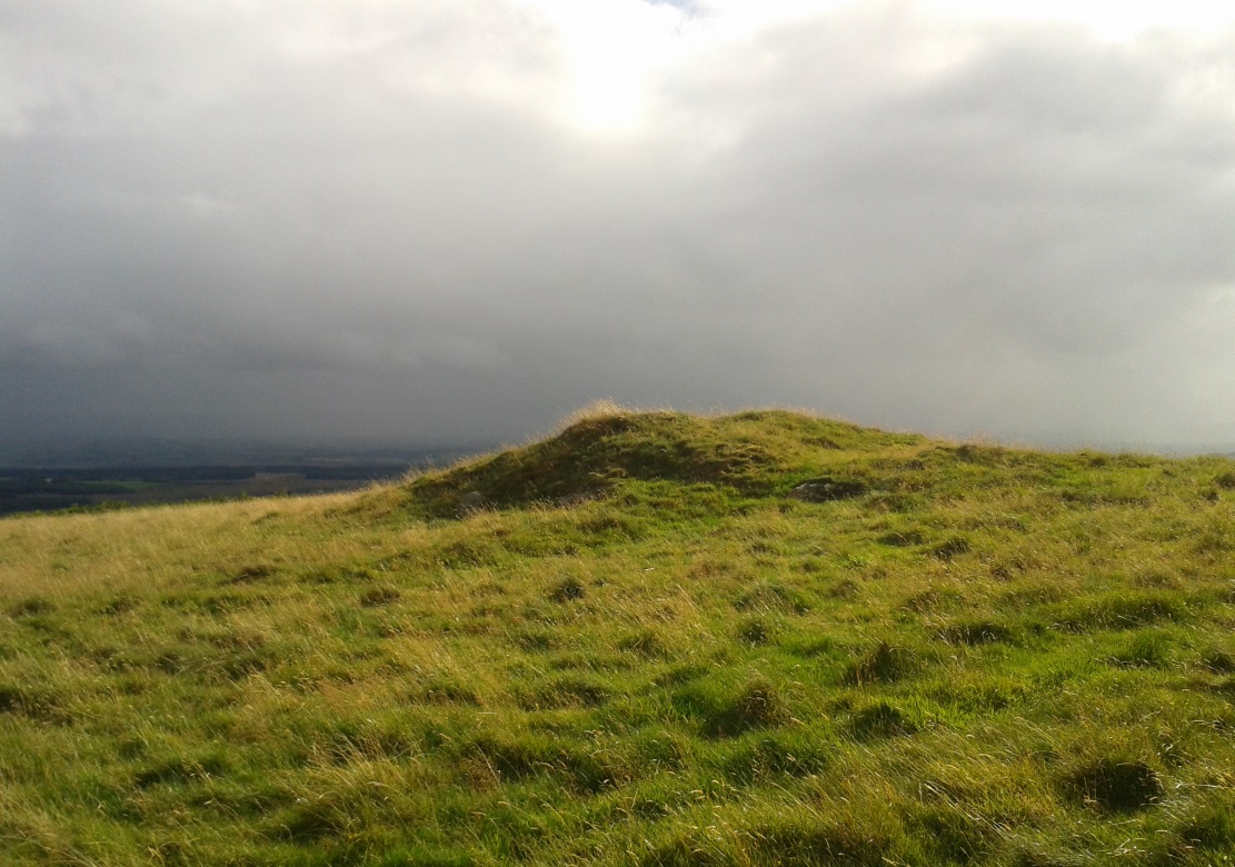
Along the A81 road from Port of Menteith to Aberfoyle, watch out for the small road in the trees running at an angle sharply uphill, nearly opposite Portend, up to Coldon and higher. Keep going, bearing right at Mondowie, then stopping at the dirt-track 100 yards or so further up. Walk up the track, thru the gate, and another 100 yards or so higher up, go thru the gate on your left. Walk up the field alongside the fence until you’re on the level and you’ll see a large rounded mound about 75 yards in the same field to your left.
Archaeology & History
This little known prehistoric tomb sits within a landscape rich in very impressive neolithic and Bronze Age petroglyphs and probably had some relationship with one or more of the carvings in aeons past. It is one of several tombs in the area.
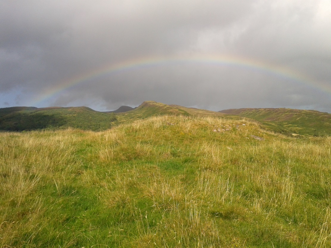
Rainbow across the tomb
The site was only recently rediscovered in the 1980s, following an archaeological survey of the area before the forestry plantation was done. Measuring about 20 yards across and about five feet high, the large mound consists of the traditional mass of hundreds, if not thousands of stones. It seems that a ring of small uprights encircled and defined the edge of the cairn, although this element is only visible on its eastern side. Its northern mass and edges have been dug into and ruined at some point in the past, leaving a mass of rubble visible beneath the encroaching grasses. The tomb has not be adequately excavated, so we do not know whether it was built at the same time of the surrounding petroglyphs. It must be noted (again) that the incidence of tombs and cup-and-ring stones is not infrequent.