The Scottish Royal Commission (1971) reported a very large
“standing stone that stood 185m NNW of Achmore House (that) was removed at the beginning of the 19th century. It was reported that is measured 4.9m in height (16ft), 1.2m in breadth and 0.2m in thickness.”
A prehistoric cairn seemed to have accompanied this monolith—as reported by Thomas Pennant in 1772—but it too has been destroyed. Pennant told us how the monolith was,
“a great rude column, sixteen feet high, four broad and eight inches thick.”
Not bad at all! It was still extant, although leaning to the southwest in the year 1790 (OSA 1791-9); appearing to have been removed about 1800. No trace of it remained when the Ordnance Survey lads looked here in 1869.
References:
Royal Commission for Ancient & Historical Monuments of Scotland, Argyll – volume 1: Kintyre, HMSO 1971.
From Otley go north straight over the river and upwards into the countryside for nearly two miles (past the TV mast on the right). As you reach near the top of the hill, there’s a turn to your right. Go on here for a hundred yards or so, then walk along the footpath to your right. After a few hundred yards, keep your eyes out for the stone just through the gate, in the walling on your left.
Archaeology & History
Although we see named on the 1853 Ordnance Survey map the respective place-names of Bride Cross House and Bride Cross Allotment, the first literary reference to any site here as a standing stone appears to be Eric Cowling (1946) who, when commenting on the pagan tradition and folklore of ancient sites, told that
“The name of Bride Cross Farm, Dob Park, is very significant, for at the meeting place of several tracks to the south-east is a squat standing stone built into a wall and marked as a boundary stone, which was probably Brides Cross.”
Bride Stone, Farnley MoorBoundary markers on top
Although I’d read about this place as a kid, it was Graeme Chappell who first brought me here some twenty years back, in one of our many exploratory forays into the prehistory of this area. It’s a nice fat squat standing stone, similar in stature to the more famous Bull Stone near Otley Chevin, a few miles to the south — though our Bride Stone here is about half as high. Only about three-feet tall, it stands by the gate at the wall-side about 200 yards down the footpath from the Dob Park Lodge road and does seems to have been used as a boundary marker, as the letters “F.F.” are carved deeply on top of the upright (possibly denoting the Fawkes family of Farnley).
Cowling’s assertion that this old stone accounts for the ‘Bride Cross’ place-name is probably right, as the site is roughly midway between the respective place-names of the House and Allotment. There is an old field-name of Crosse Close in the vicinity, from 1692, but I haven’t located it. If such a cross ever existed nearby (most likely, it’s gotta be said), it’s obviously the relic which left the place-names — though the standing stone was certainly here first! As yet, we’ve found no references to this place before 1853…which can’t be right…
Folklore
Seems to be a petrification legend in here somewhere. Although the short tale doesn’t say as much, it is supposed to have got its name through “the murder of a bride, rejected by a suitor, on her return from a wedding.” Indeed, I’d go so far as to say ‘fertility’ as well!
Eric Cowling (1946) really stuck his neck out and reckoned sacrifices occurred here in the not too distant past. This may relate to the nearby Haddock Stones, a few hundred yards south, thought to derive its name from a cairn and ‘altar stones.’
References:
Bennett, Paul, The Old Stones of Elmet, Capall Bann: Milverton 2001.
Cowling, E.T., Rombald’s Way, William Walker: Otley 1946.
Phillips, Guy Ragland, Brigantia — A Mysteriography, RKP: London 1976.
Smith, A.H., The Place-Names of the West Riding of Yorkshire – volume 5, Cambridge University Press 1961.
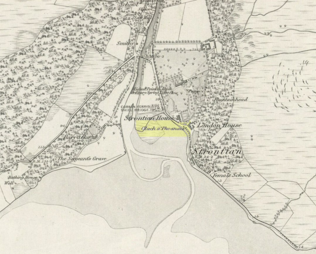
As you enter the village from the east, onto the A861 road, the Strontian Hotel is on the right-hand side of the road and you can’t fail to notice. Stop!
Archaeology & History
Clach a’ Phaonais on 1872 map
Shown on the first edition OS-map of the region in 1875, this old worn standing stone, more than six-feet tall, can be seen at the edge of the drive. There’s an iron ring is attached to it, which I thought might have made it an old Bull Stone in bygone days, but no such lore is remembered. Also known as the Branks Stone, it’s Gaelic name probably means the ‘stone of penance,’ and folk were chained to it in eaelier days for bad behaviour. It was widespread across the Highlands to tie criminals to stones and wooden poles, naked, for 24 hours and let the midges get to them. Crime was down to a minimum up here!
Folklore
As the locals at Strontian Hotel told me (thanks Finlay), “several stories have emerged locally. It marks a clan chief’s grave, a sighting stone for the equinox but the most plausible one is based on the fact that there is an iron ring on the side of the stone facing the loch and it was used to tie up barges taking lead from the local lead mine. It supplied the raw material for shot during the Napoleonic and Crimean wars.”
Aknowledgements: Big thanks to Anne and the Megalithic Portal for additional help on this one.
From Foulridge go west up the long windy road (B6251) till you hit the old crossroads near the top. Turn right and go on till you hit the modernised farmhouse on your right, where you’ll notice a modern upright stone in the entrance. You need to go back about 70 yards and you’ll see this old stone in the wall.
Archaeology & History
“Standing Stone Road’ stone!
Less than a mile northwest of Foulridge along the southern stretch of the Whitemoor Reservoir, on the northern outskirts of Colne, we find the intriguingly-named ‘Standing Stone Lane’ — which seems to indicate that at some time in the not-too-distant past, an old monolith could be found hereabouts. The old maps show the boundary line turning at right angles just near the crossroads, which is where I thought we might locate some remains of an old standing stone. But it wasn’t to be. Instead, we need to travel about 100 yards west along the single-track road, just below the reservoir — and there, in the walling, plain for all to see, is what may be the old standing stone which gave the road its name. I found this site in early July 2008, and although we can’t be 100% certain, it’s not too bad a good contender as the monolith which first gave the road its name. Does anyone know anymore about it?
More probably though (and this is what ‘feels’ right): the original stone which gave the road its name was much bigger than this little thing, but was probably destroyed when the reservoir here was constructed. How much d’ y’ wanna bet!?