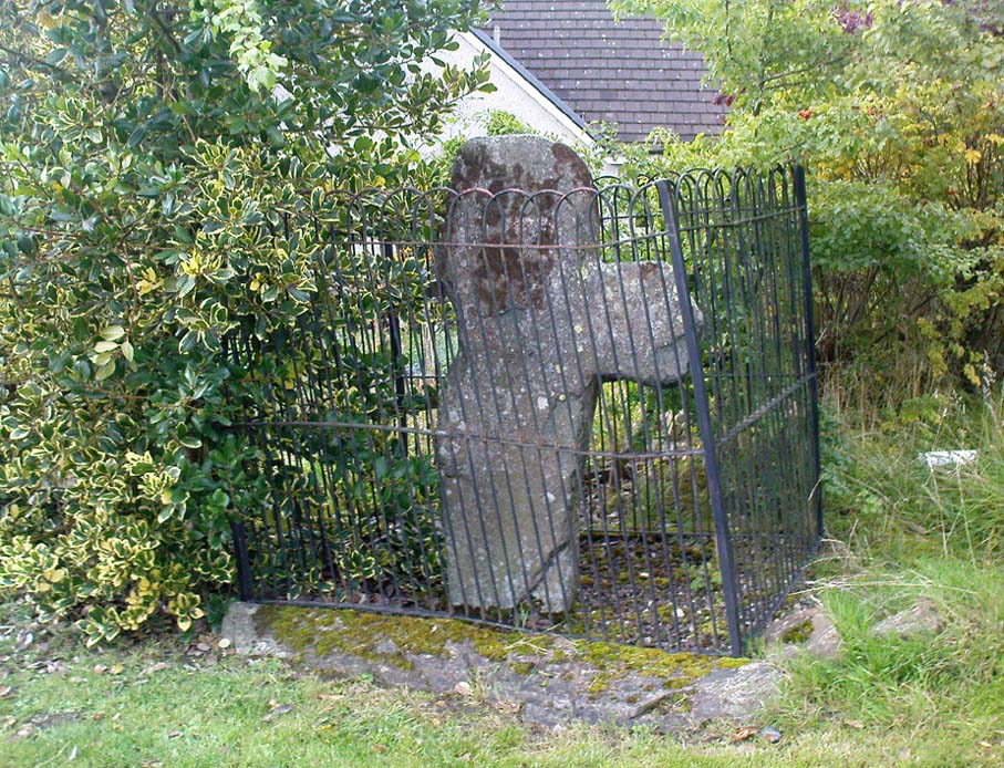
From Aberfeldy, take the B846 road over the river bridge, past Weem, a couple of miles down the valley until you see the small road on the right which leads up to the ancient hamlet of Dull. Go up and round the corner until you reach the centre of the village; and here the road turns back downhill. At this point, right by the roadside, entrapped within old railings, you’ll see the Cross of Dull.
Archaeology & History
Dull Cross behind bars
Standing more than three feet tall, the remains of this old cross with one of its extended arms broke off in previous centuries, was one of three such monuments that used to stand in the valley. This and its associates were, according to christian legend, placed as markers at an ancient centre of christian learning at Dull around the time of Adamnam (who died in Glen Lyon in 704 AD). The area was said to be an early druid college, which was later incorporated into early christian teachings. Hilary Wheater (1981) also told that in previous centuries, if anyone fell foul of the law,
“Within the boundaries of these crosses debtors, offenders or miscreants were protected from retribution. One of the crosses stands in the centre of Dull village to this day, having been used as a market cross in more recent times, and the other two, having been stolen for use as gateposts during the (19th) century, were placed in the old kirk at Weem for safety.”
References:
Stuart, John, The Sculptured Stones of Scotland, Aberdeen 1856.
Wheater, Hilary, Aberfeldy to Glenlyon, Appin Publications: Aberfeldy 1981.
To get here, follow the same directions to reach its nearby colleague of Carse Farm south — but instead of walking down the track to where its companion is found, this small ring of stones is found a coupla hundred yards into the first field by the roadside. Unless the field’s fulla corn (in which case, give it a miss cos even if you do find it, you won’t be able to make much out), y’ can’t really miss it!
Archaeology & History
As with its nearby companion of Carse Farm south, this small “ring” of four stones is found along the Tay valley floor and, though cited as a stone circle in many archaeology tomes, should more accurately be defined as a cairn circle of sorts. Structurally akin to other four-posters, it reminded me of a distant companion in North Yorkshire more than 200 miles south: the Druids Altar at Bordley, which is also a robbed prehistoric tomb and not a stone circle. But it’s a fine little site sat amidst the majestic temple of surrounding hills on all sides, bar east, where the Tay valley reaches into the distance.
Faint cup-marksCarse Farm, looking north
Like its damaged companion in the field below, some of the stones in this circle also have well-defined cup-markings on top of the uprights; although when we visited here, low cloud and late daylight conditions prevented us from getting good images of the cup-marks concerned (as the photo of one of them here illustrates). The cup-markings are, curiously, carved on the top of the small standing stones.
Described briefly in Alexander Thom’s Megalithic Rings (1980), he regarded its geometry as “circular” in structure. Aubrey Burl (1988) gave the lengthier archaeological history of the site, telling:
“On the ‘carse’, or lowland…this 4-poster was excavated in 1964. When Coles saw it in 1907 only three smallish stones remained standing although “it seems clear that at this site there were originally four Stones as in so many other Perthshire groups”… The SW stone was missing but halfway between the NW and SE stones a long, thin slab lay half-buried.
“Coles noticed that there were cupmarks on the tops of both the NE and SE stones. The SE had three carvings but the top of the NE had no fewer than 17, the largest ‘cup’ being 4 by 3½in (10 x 9cm). In the group were two ‘dumb-bells’. In the same field the farmer had dragged away a buried stone which was also cupmarked.* (my italics, PB)
“Of the three standing stones, the NE is 3ft 11in (1.2m) high; the SE, 5ft 1in (1.6m); and the NW, 4ft 1in (1.3m). These heights…are almost double those cited by Coles (1908: 126).
“”The 1964 excavation discovered the SW stonehole. The 5ft 10in (1.8m) long stone lying at the centre of the 4-Poster was erected in it, a task made easier by the fact that its base had been keeled… The base was unweathered showing that the stone had been toppled in quite recent times as had the stones of the two Fortingall 4-Posters…3¾ miles to the WSW. The four stones stood at the corners of a rectangle 12ft by 8ft (3.7 x 2.4m) on a long ENE-WSW axis. They also stood on the circumference of a circle 14ft 5in (4.4m) in diameter.
“A tapering pit was discovered against the inner face of the NE stone, about 2ft 6in (76cm) across and 1ft 2in (37cm) deep. It was filled with cremated bone and sticky black earth and charcoal. At the bottom, a collared urn lay on is side, its rim decorated in geometrical designs. A flint flake lay near it. Within the 4-Poster there were three shallow pits, two between the NW and NE stones, another between the SE and SW. Their edges were clean and they had been backfilled with brown loam. The excavators thought they might have “been used for stabilising props during the erection of the stones.” …As the heaviest block, that at the NW, weighed about 6 tons it would have required 20 to 30 people to drag it upright…and the use of such props would have made their insertion safer.”
Unless the people building this site were dwarves, we’ve gotta re-assess this latter remark (which Burl quotes from the earlier archaeologist’s report from the 1960s). Having personally been involved with the creation of modern stone circles with stones larger than the ones here, we know that the uprights here could have been erected by 8-10 people at the very most.
Archaeology and folklore records describe many other prehistoric sites along this section of the upper Tay valley, but it’s also very likely that other “circles” or cairns of similar structure to the two known at Carse Farm once existed close by that are not in modern literary accounts.
References:
Burl, Aubrey, Four Posters: Bronze Age Stone Circles of Western Europe, BAR 195: Oxford 1988.
Pretty easy to find – assuming it aint at the height of summer and the crops are approaching maturity, otherwise you’re only gonna see its head! But, this aside: from Aberfeldy, take the B846 road over the river bridge that bends you along the valley of the River Tay towards Appin of Dull. After some 2 miles you’ll pass the right-turn up to Dull. Go past this for another coupla hundred yards or so, watching out for the left-turn down towards the farmhouse of Carse and park up where you can (if you go past it, there’s the second turn up to Dull, again on your right, where you can turn round). As you walk down the track towards Carse Farm, watch out on your right in the field below Carse I, in the second field down. You can’t really miss it. (and the farmer here is spot on if you ask to check the stone – as long as the crops aint growing)
Archaeology & History
Although all that’s left of what is thought to have been a once proud stone circle is the singular upright standing stone in the middle of the field. Aubrey Burl (1988) thought that this was one of the typical “four poster”rings that scatter our isles, but I’m not so sure misself. There were other stones associated with the site when Burl described it, but these were covered over in our visit here a few months back — which is a pity, as two of the stones are reported as possessing cup-markings (if/when we revisit the site, I’ll try get some images of the respective stones and add them on TNA as individual carved stones). The site gives the distinct impression of it having a funerary character of some sort and not a true stone circle — and this was strongly suggested by some of the finds inside the “ring”, described below.
Fred Cole’s old drawingAubrey Burl’s groundplan
Both this and its associated “circle” a few hundred yards away — known as Carse Farm north — sit on a flat level of ground in the Tay valley, with rounded hills all most sides. This landscape setting was obviously of some importance to the people who put the circle here in the first place but, not living in the region, it’s difficult to assess the mythic relevance some of the hills will have obviously played in the siting of these stones.
In bygone days, it was reported that the much of the site was ploughed away due to agricultural excesses, so there was obviously much more to it in earlier centuries. Describing the solitary stone that’s left today, along with the earlier excavation results, Mr Burl (1988) wrote:
“The stone still standing, of quartziferous schist, is 6ft 3in (1.9m) high. Its longer faces are aligned NW-SE. 32ft 6in (9.9m) to its SW is a large prostate block, sub-elliptical and about 8ft long and 4ft 3in wide (2.4 x 1.3m). It has probably fallen outwards. (my italics, PB) If so, when standing near the top of its inner face were four cupmarks in a cross pattern.
“About 32ft ((9.8m) to its NW is a fallen and enormous schist slab, 11ft long and 5ft wide (3.4 x 1.5m). It also appears to have toppled outwards. Near the bottom of its inner face are two cupmarks. The situation of these three stones suggests that they once stood at the corners of a rectangle some 32ft (9.8m) square, the pillars of a huge four-poster nearly six-times the national average and with an internal area ten times bigger than the small 4-poster (Carse Farm north, PB) just to its north.
“Excavation in 1964 found the socket from which the great prostrate slab had been dragged… Cash (1911) had noted the presence of a small stone inside the ring about 20ft (6.1m) west of the standing stone. It proved to be 4ft (1.2m) square with a carefull-dressed face. It had been set upright, standing about 1ft 4in (41cm) above the ground. Three sides of the worked face ‘had been carefully chiselled away to a straight edge.’ It may have been a slab lining the inner central space of a destroyed ring-cairn. Burnt bone was found near it. There was also a rounded river pebble with a worked hollow on one side…”
Folklore
Carse Farm stone
Stewart (1964) described the site as having been “christianized” not long ago, by having the northernmost standing stone in the ring removed. This is intriguing inasmuch as “north” is the place of greatest symbolic darkness in the pre-christian mythos, and represented death and illumination in magickal terms. North was also the point taken by witches and shamans in their excursions into Underworlds, usually via the North Star, which tethered the Earth to the heavens (see Godwin’s Arktos [1993], and Grant, The Magical Revival [1973]) In the removal of this northern stone for the reasons given, that implies some magickal events or folklore were in evidence here when this took place. Anyone got any further information along these lines, or has it long since been subsumed?
References:
Burl, Aubrey, Four Posters: Bronze Age Stone Circles of Western Europe, BAR 195: Oxford 1988.
Here we have another case of another loch in Scotland that was said by local people to be inhabited by legendary water monsters. In the tale which follows we may simply have a case of a very bad accident that was, in more superstious times, bestowed upon this legendary animal. We may never know. James Kennedy (1928) told the story, saying:
“It was inhabited, like Loch Derculich, by the ‘Each Uisge‘ of Icelandic origin. On summer evenings it could be seen roaming at large on a green meadow adjacent to the tarn, and to all appearance a canny enough creature. One summer Sunday afternoon, six Strathtay girls and a boy set out from their homes to inspect the ‘Each Uisge.’ They found him, patted him on the head and neck, and this kindness is apparently relished, for it lay on the sward and allowed them to sit on its back. The boy, who had a semi-bald scabbed head, stood at a distance and watched developments. He concluded that this animal was not the genuine horse it seemed to be, and thought that it grew considerably larger than it was at first. When the Each has the six girls comfortably seated on its back, it suddenly rose, plunged into the loch, and drowned the lot. The boy immediately took to his heels and the Each after him, but fear enabled the boy to outstrip the horse, who would stop now and again in the pursuit and cry, “Fuirich mo ghille maol carrach! Fuirich mo ghille maol carrach!” — Stop, you bald scabbed-headed boy. Ultimately the Each gave up the chase, and the boy, much frightened, got safely home and related all that happened on that eventful Sunday evening. The parents of the girls found parts of their bodies floating on the waters of the loch, and the name Loch Lassie was given to it, which it retains to this day.”
References:
Kennedy, James, Folklore and Reminiscences of Strathtay and Grandtully, Munro Press: Perth 1928.
Although this upland loch is today renowned as little more than a decent fishing spot, the waters here were long known to be haunted and the abode of a legendary water spirit. In local tradition, the loch is said to be named after “an ancient Chief of Pictish origin” — whose burial mound is nearby — and in James Kennedy’s (1928) fascinating folklore work he also told that,
“Loch Dereculich was the habitation of a ‘Tarbh Uisge’ (water bull), the dangerous water demon… This dreaded monster, as the Norwegian peasant will gravely assure a traveller, demands every year a human victim, and carries off children who stray too near its abode… Less than one hundred and twenty years ago, the Loch Derculich Water Bull was seen sauntering along its shores. At peat-making times it was observed very frequently.”
References:
Kennedy, James, Folklore and Reminiscences of Strathtay and Grandtully, Munro Press: Perth 1928.