Keillor, Kettins, Perthshire

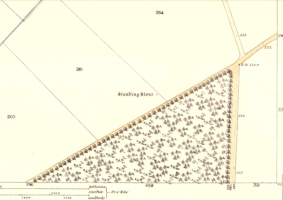
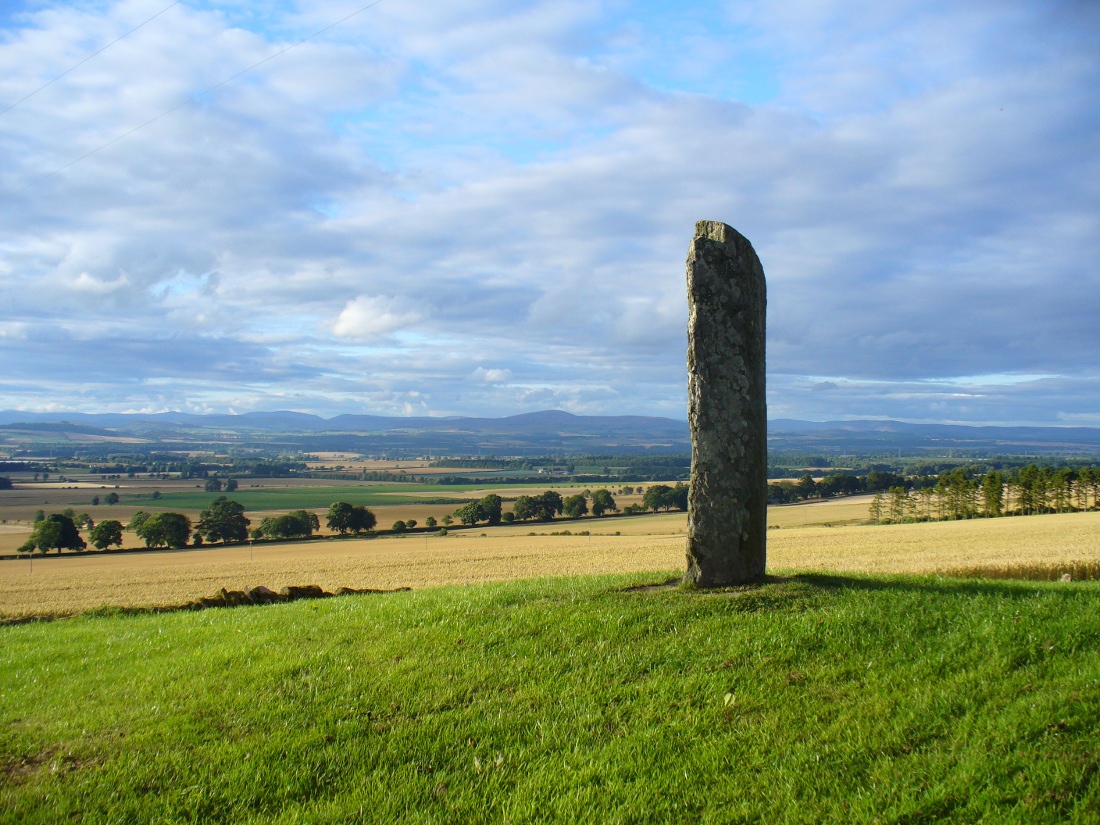
Standing Stone:  OS Grid Reference – NO 27332 39760

The tall carved stone at Keillor

Also Known as:

  1. Baldowrie
  2. Canmore ID 30545
  3. High Keillor
  4. Symbol Stone

Getting Here

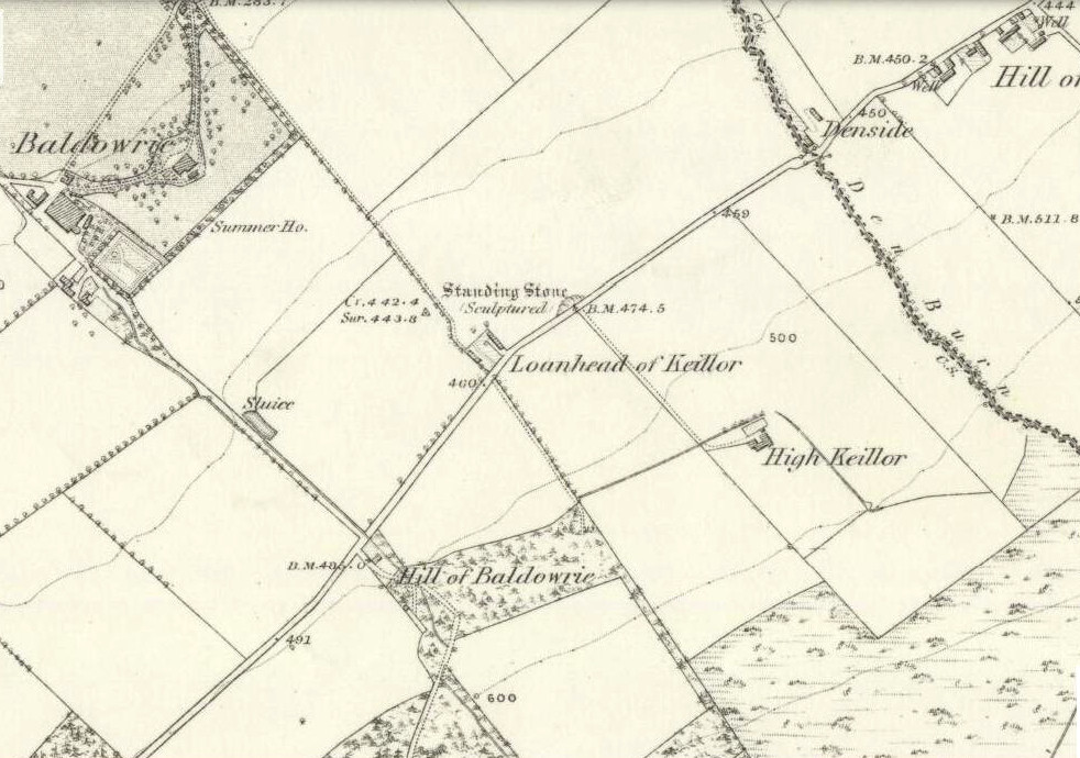
Take the minor road that runs from the small town of Newtyle (in Angus) westwards to Kettins (in Perthshire). Less than a mile on, go up the first turn-off on your left to Kinpurnie Castle and continue (past the castle) for less than a mile. Keep your eyes peeled on the right-hand side of the road, opposite the drive to High Keillor – and you can’t really miss it!

Archaeology & History

Another feel of Keillor's Stone
Another feel of Keillor’s Stone

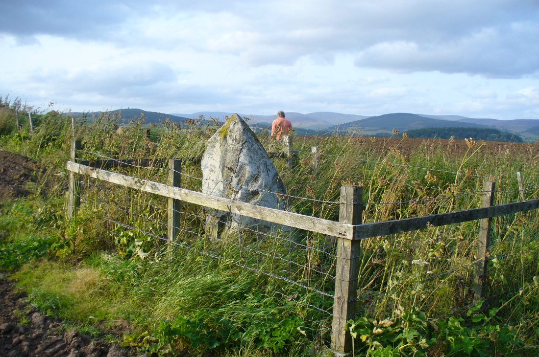
A fascinating site in an excellent setting.  Here we have a 6-7 foot tall standing stone living upon a what is most probably a Bronze Age tumulus (possibly neolithic, but we aint sure), on whose south-face were carved a series of Pictish symbols many many centuries ago.  In the surrounding district there is a vast wealth of similar sites (and many destroyed, like the lost Hill of Ballunie stone circle only a few hundred yards along the road), highlighting that this region was very important indeed to the prehistoric peoples of Strathmore and the Sidlaw Hills.

W.J. Skene's 1832 drawing
W.J. Skene’s 1832 drawing

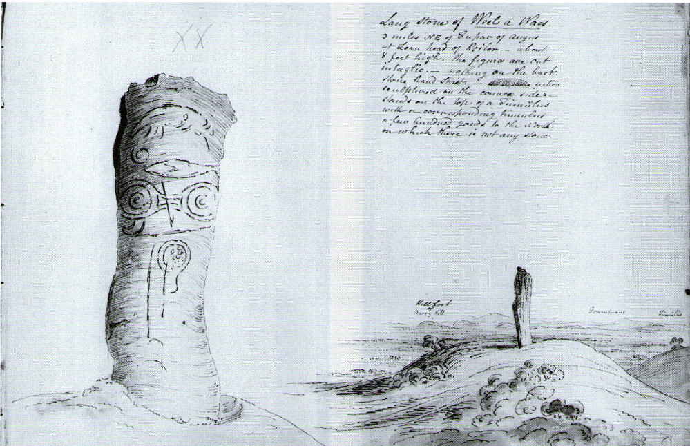
The Keillor stone was described and illustrated by several of the giant Scottish antiquarians. When James Skene visited the site in the 1830s, the tumulus upon which the stone stands was still pretty complete, as his old drawing from 1832 clearly shows.  Since then the track beside the monument has widened and the road took away half of the burial mound.  But the place has lost little of its majesty.

Another 19th century historian, William Oliphant (1875), when describing the beauty and history of the Sidlaw Hills, below whose edges the old hamlet of Keillor stands, told of this,

“old and striking monument, making the spot on which it stands historical, though no syllable of the history has come down to us.  It is, one writer says, “one of those remarkable sculptured monuments of the ancient inhabitants of Scotland, embellished, in this instance, with the rude outline of the boar.”  Another writer says, “at Baldowrie there is an erect Danish monument six feet high.  It contains some figures, but they are almost entirely defaced.”

In John Stuart’s (1856) superb magnum opus he told that this carved pillar with “a boar” on it, standing on an ancient “tumulus of earth and stones” was found to have evidence of several burials inside when a dig at the site occurred which, he told, “I was present (at) in the autumn of 1854.” He described the site as follows:

Stone with carved symbols (after RCAHMS 1994)
Stuart's 1854 drawing of the carved stone
Stuart’s 1854 drawing of the carved stone

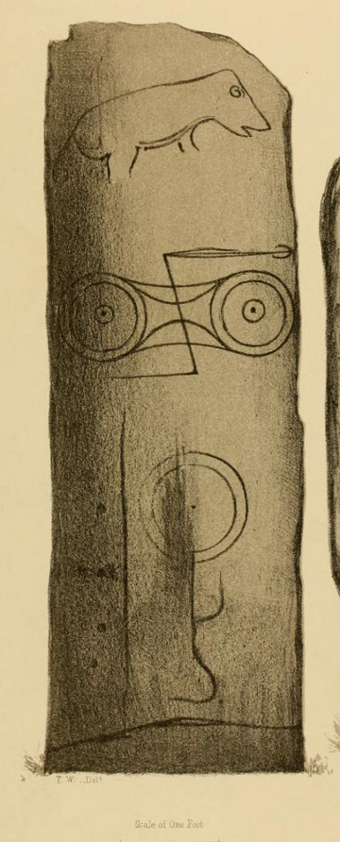
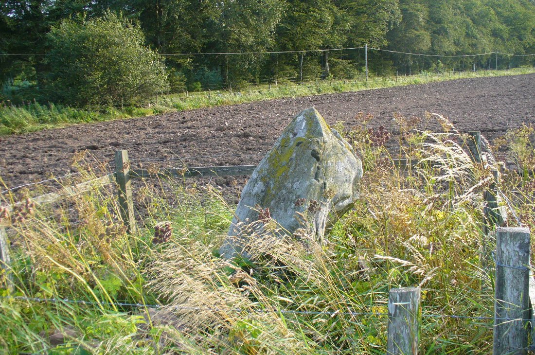
“The Stone at Keillor is placed on a tumulus on the north slope of the Hill of Keillor, in the Parish of Newtyle, and Shire of Forfar. It is a rough stone, formed of gneiss, convex in front, and rugged behind. The tumulus on which it is placed is formed of earth and stones, and several cists containing bones have been found in it. Ancient sepulchral remains have also been dug up in various parts of the adjoining field.

“The stone was broken across some years ago about a foot above the ground, but the parts have recently been clasped together, and the stone replaced in its original site by orders of Lord Wharncliffe. The present drawing was made with much care by Dr. Wise, and is more perfect than the copy in Mr. Chalmers’ volume.  The surface of the stone is so rough, that it is sometimes with difficulty that the incised lines can be satisfactorily distinguished from natural fissures, but having examined the stone in a variety of lights, and compared Dr. Wise’s sketch with the original, I am inclined to think that the drawing is as satisfactory as can now be obtained.  There is a rough sketch of the stone among Dr. Hibbcrt’s papers, with a supposed Gaelic inscription at the top, meaning “the burying place of the slain,” furnished to Dr. Hibbert by the late Mr. Donald Gregory.  Of such inscription 1 could see no trace.”

The old stone himself
Faint carvings just visible

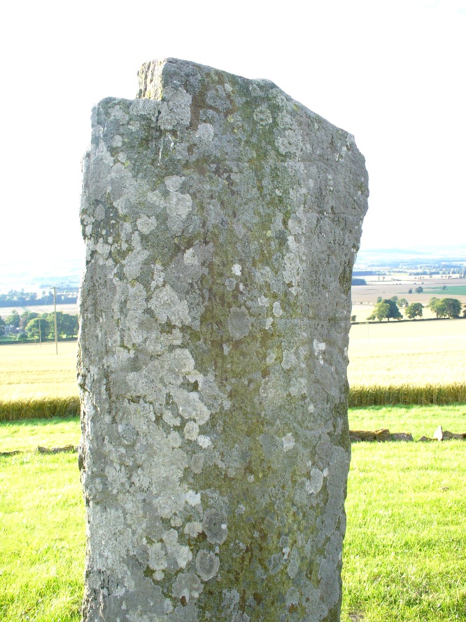
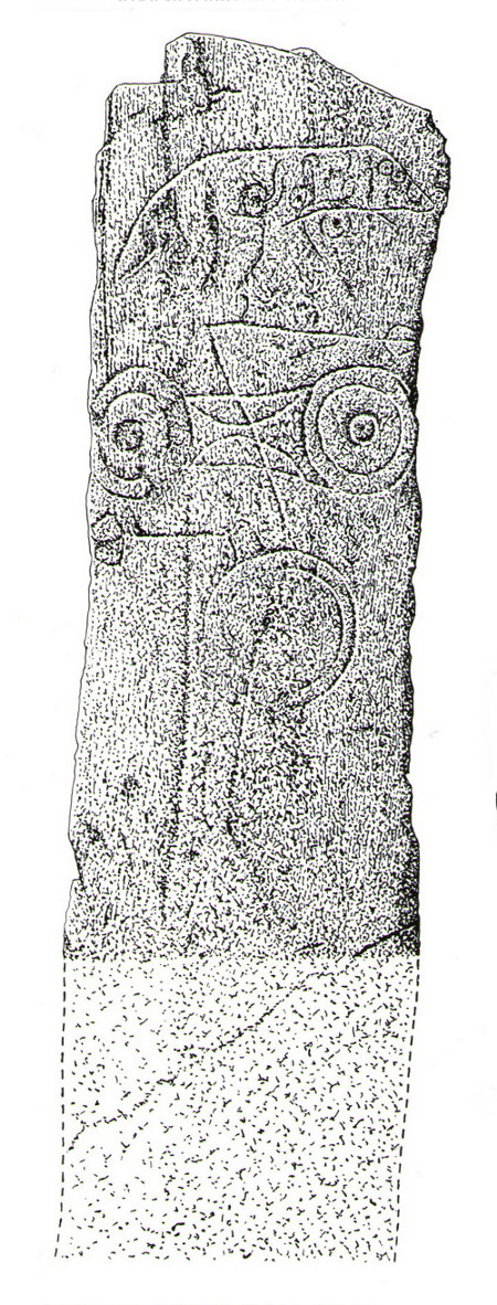
And as far as I am aware, this Gaelic inscription has not subsequently been recorded.  But considering the position of the stone in the landscape, it’s understandable if some of the carvings have eroded away by simple weathering.  Indeed, when Paul Hornby and I visited here only a couple of weeks ago, despite the weather conditions being excellent, the carvings were difficult to make out. Modern interpretations differ between the topmost animal carving being either a wolf or a boar. Below this we see the more common Pictish symbol described as a double disc and Z-rod symbol, for which academia still struggles to afford cogent explanations.

Keillor stone on 1865 map

Whilst the prehistoric age of the tumulus on which this stone stands is not in doubt, we don’t know exactly when this stone was first erected here.  Whilst some of the early accounts—including the Ordnance Survey team who first visited here in 1860—describe it in an upright position, when A.J. Warden (1880) wrote about it in his massive survey of the region, he noted that wasn’t always the case:

“On the north slope of the Hill of Keillor, in the parish of Newtyle, there is a rough stone composed of gneiss, somewhat convex in front but rugged behind. It is placed on a tumulus formed of earth and stones, and several cists containing bones were found in it; while, in the adjoining field, ancient sepulchral remains have also been found.  The stone was broken across about a foot from the ground, but the parts have been again united and the stone replaced on its original site. On the stone there is the figure of an animal, below which are the spectacle and other symbols, all incised.”

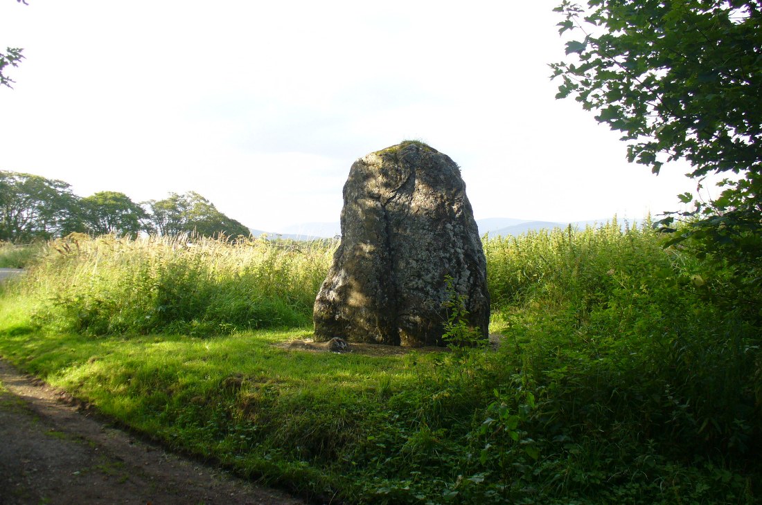
The stone presently stands on a modern plinth to protect it from the elements and such things.  It was erroneously described in the Royal Commission’s 1999 survey of Pictish monuments as being just “1.4m in height”, whereas it is in fact some 6½ feet tall, or around 1.98m.

The Great Pyramid to the northwest

The view from here, east, north and west is superb. The high rolling hills of Angus stretch into the north and eastern skies; whilst more westerly are the grand olde mountain ridges into deepest Perthshire. And looking northwestwards from our old standing stone, one shapely mountain in particular is notable, standing out upon the ridge of distant hills: a great pyramid which I initially thought may have been Ben Vorlich.  But thanks to the help of several local people, have found that it is in fact Schiehallion – the great Mountains of the Fairy Folk, about 50 miles away!  Some folk think that it may have had relevance in the animistic formula with this monument—and I’ll hazard that it did too…

…to be continued…

References:

  1. Allen, J. Romilly, Early Christian Monuments of Scotland, 1903.
  2. Coutts, Herbert, Ancient Monuments of Tayside, Dundee Museum 1970.
  3. Guthrie, James C., The Vale of Strathmore – Its Scenes and Legends, William Peterson: Edinburgh 1875.
  4. Jervise, Andrew, Epitaphs and Inscriptions from Burial Grounds and Old Buildings in the North-East of Scotland – volume 1, Edmonston & Douglas: Edinburgh 1875.
  5. Mack, Alastair L., Field guide to the Pictish symbol stones, Pinkfoot Press 1997.
  6. MacPherson, J.G., Strathmore: Past and Present, S. Cowan: Perth 1885.
  7. Marshall, William, Historic Scenes of Forfarshire, William Oliphant: Edinburgh 1875.
  8. Royal Commission on the Ancient & Historical Monuments of Scotland, South-East Perth: An Archaeological Landscape, HMSO: Edinburgh 1994.
  9. Royal Commission on the Ancient & Historical Monuments of Scotland, Pictish Symbol Stones: A Gazetteer, Edinburgh 1999.
  10. Stuart, John, Sculptured Stones of Scotland – volume 1, Spalding Club: Aberdeen & Edinburgh 1856.
  11. Sutherland, Elizabeth, A Guide to Pictish Stones, Birlinn: Edinburgh 1997.
  12. Warden, Alex J., Angus or Forfarshire: The Land and People – Descriptive and Historical – volumes 1, Charles Alexander: Dundee 1880.

© Paul Bennett, The Northern Antiquarian


Rocking Stones, Kirriemuir, Angus

Legendary Rocks (destroyed):  OS Grid Reference – NO 3813 5496

Archaeology & History

Like many rocking stones across the British Isles that were written about by early 18th and 19th century authors, the ones at Kirriemuir have fallen prey to the vandalism of those people (christians, Industrialists and other self-righteous fools) that has so blighted our heritage, and ancestral history, with an intolerance of indigenous beliefs and remarkable geological formations.  But, I suppose, at least we have a record of them, which at least in some way gives us the ability to add further our knowledge of the traditional practices of our peasant ancestors and their perception of the landscape.

Rocking stones shown on 1865 6-inch OS-map
Rocking stones shown on 1865 25-inch OS-map

The exact location of the legendary rocks were highlighted on early Ordnance Survey maps, thankfully; and there were in fact two rocking stones here, very close to each other by the sound of it.  Mentioned only in passing by E.S. Valentine (1912), the place was best described in A.J. Warden’s (1884) massive history work on the region. He told that:

“On the top of the Hillhead, Kirriemuir, there were two fine specimens of these interesting memorials, upon which the dwellers in the district looked with wonder and awe.  These time honoured monuments of a long past age were, in 1843, blasted with gunpowder, and the shattered pieces used in building dykes and forming drains, to the deep regret of antiquarians, and of the inhabitants of the district. …These stone memorials of a remote age are thus described by the Rev., T. Easton, D.D., in the new Statistical Account of the parish — ‘The one of them is a block of whinstone, nearly oval, and is three feet three inches in height, and four feet ten inches in breadth. The other, of Lintrathen porphyry, is two feet in height, eight feet in length, and five feet in breadth.’ He gives no description of the bases upon which the magic pivots moved, or other details of them.”

About a half-mile east you would have looked across at the large standing stone on Kirriemuir Hill, which legend asserts was once a stone circle (it too, destroyed).   If anyone has any further information about these old stones, please let us know…

References:

  1. Valentine, E.S., Forfarshire, Cambridge University Press 1912.
  2. Warden, Alex J., Angus or Forfarshire: The Land and People – Descriptive and Historical – volumes 1 & 4, Charles Alexander: Dundee 1880-1884.

© Paul Bennett, The Northern Antiquarian


Caddam, Kirriemuir, Angus

Stone Circle (remains of):  OS Grid Reference – NO 3848 5625

Also Known as:

  1. Caldhame
  2. Canmore ID 32196
1865 OS-map showing the stone
1865 map showing the site

Getting Here

From Kirriemuir centre, take the B956 out of town until you hit the B955. Head north along this road until the houses are behind you. You’ll pass a woodland on your left straight away and as the road starts to bend right, take the first small road on your left. Go along here for about 150 yards and stop. Look into the fields across the road and there it is!

Archaeology & History

Caddam stone, looking north
Caddam stone, looking N

The small standing stone we see here today, within in a small fenced enclosure by the wall-side, was highlighted on the 1865 OS-map in exactly this position.  However, its earlier history seems much more intriguing – and at least one account tells us how this solitary stone was once part of something much bigger—implying that it was of some considerable important to our ancestors.  In A.J. Warden’s (1884) magnum opus on the history of this region he told that,

“A circle of stones was discovered in trenching a field at Caldhame, a little to the north of (Kirriemuir) town. It was over sixty feet in diameter, and in the centre was a large standing stone. The circle was removed, but the centre stone was left.”

The Caddam stone, looking SW
Caddam stone, looking SW

Another local writer later reported that there were remains of six stones in the field immediately below the remaining upright, but these have since disappeared. The descriptions seem to imply that the stone was a part of a burial complex of some sort.  Sadly, all we see today is this one remaining upright: some 5 feet tall, but looking shorter as it leans to its side, seemingly ready to fall.  Do any local people know anything more about this place?

References:

  1. Royal Commission on the Ancient and Historical Monuments of Scotland, The Archaeological Sites & Monuments of Central Angus, Angus District, Tayside Region, HMSO: Edinburgh 1983.
  2. Warden, Alex J., Angus or Forfarshire: The Land and People – Descriptive and Historical – volume 4, Charles Alexander: Dundee 1884.

© Paul Bennett, The Northern Antiquarian


Kirriemuir Hill, Kirriemuir, Angus

Standing Stone:  OS Grid Reference – NO 3917 5463

Kirriemuir Hill standing stone

Also Known as:

  1. Canmore ID 32295
  2. Hill of Kirriemuir
  3. Stannin’ Stane

Getting Here

Various ways to get here, but make your way to the large cemetery up on the top of the hill.  Once here, there is a playground and some trees. Go through the playground along the footpath for about 100 yards and you’ll eventually come to this great stone standing in front of you.

Archaeology & History

The Kirriemuir Stone, with a curious elemental at its base!

This place felt to have some real intrigue and hidden history laying close by when I came here for the first time the other week with Paul and Lindsey.  Notably standing on the top of the hill northwest above Kirriemuir town, with an excellent view all round (just about!), speaking with hills and rolling countryside and the feel of other monuments of the same age…but seemingly all alone at the moment…

The Kirriemuir Hill standing stone is reputedly the last survivor of a megalithic ring, or stone circle, according to old tongues and local folklore—though Aubrey Burl didn’t include it in his magnum opus.  And apart from the smaller piece of stone near its base and the curious long stone in an adjacent field wall not far away, this large 9-foot tall standing stone seems the last of its clan up here.

The stone was mentioned briefly in A.J. Warden’s (1884) massive history work on the region, where—near some legendary rocking stones that have long since been destroyed—he simply told that,

“The remains of a standing stone about 9 feet in height, by about 4 J feet in breadth, still rears its head above the Market Muir, and forms a very conspicuous object there.”

It hasn’t fared too well in archaeological surveys either, but thankfully local historians have written about it. Herbert Coutts (1970) told it to be,

“An impressive standing stone about 9ft (2.7m) in height and 6½ft (1.9m) broad at the base.  A recumbent stone is reported to have once lain nearby but has long since been removed.”

This recumbent stone may be the one sitting in one of the adjacent walls.

Folklore

Notice board telling tales

A notice board set back from this great stone gives a good outline of its known history, archaeological speculations and the folklore of the place. As well as it being said that Kirriemuir’s hill stone was once part of a stone circle, local markets were once held close by.  Ascribed as being the burial site of three robbers, local historian David Allan (1864) was the first to write the legend which told that,

“three robbers, who had robbed a man in the Hill market, sat down to divide their ill-gotten gain beside the ‘staning stane’ and as they were so employed, the stone, in some miraculous manner, split in two, burying the robbers beneath it.”

The local history board tells “that no one has ever dared since to uplift the robbers’ loot, as the same fate might befall anyone who tries”!

…to be continued…

References:

  1. Allan, David, Historical Sketches, Original and Select of Kirriemuir and District, Robert Park: Dundee 1864.
  2. Coutts, Herbert, Ancient Monuments of Tayside, Dundee Museum 1970.
  3. Warden, Alex J., Angus or Forfarshire: The Land and People – Descriptive and Historical – volume 4, Charles Alexander: Dundee 1884.

© Paul Bennett, The Northern Antiquarian


Carrot Hill, Inverarity, Angus

Cup-Marked Stone:  OS Grid Reference – NO 4545 4000

Getting Here

Newly found cup-marked stone

The stone is situated on the north-facing slope of Carrot Hill (almost equidistant with neighbouring Dodd Hill actually) at 225 m OD.  Use of a  GPS and the co-ordinates above are very definitely recommended for finding this stone which lies flat on a heather covered hillside.  You most likely won’t locate it without them.  There is ample car parking space at the popular viewpoint car park on Carrot Hill (NO 464 408), walk to the summit trig point and follow your GPS from there.

Archaeology & History

This cup-marked stone was first noticed in February 2012.   Remarkably, this stone seems to have been previously unrecorded despite lying just metres from a small path through the heather.

There are at least 15 cup marks on this sandstone boulder which was measured to be  1.2 x 0.7 x 0.2 m in size.  There is no evidence of any rings around any of the cups. 

The closest known examples of more rock art are just over four kilometers away to the west at Huntingfaulds where there is a cup and ring marked boulder.

© Stuart Anthony, 2012