Cairns (destroyed): OS Grid Reference – NS 783 926
Archaeology & History
At least two old tombs that could once be seen here are long-gone by all accounts. They could be found 200 yards south of the remaining King’s Park cup-and-ring stone. The first was described by the Royal Commission lads (1963) as a well-defined cist, “situated within a gravel mound and (it) contained a skeleton.” Another tomb site was described a few years later:
“A second short cist was found just within the cairn material 3m SE x E from cist no.1. It consisted of a capstone set on built-up side walls, the bottom courses being five slabs on edge. The internal measurements were 64cm long and 48cm wide and 60cm deep. This second cist was orientied NE-SW with its floor made of small pebbles on which lay a late incised beaker and a small piece of human skull.”
References:
Royal Commission on Ancient & Historical Monuments, Scotland, Stirlingshire – volume 1, HMSO: Edinburgh 1963.
Thompson, J.K., “Coneypark: Bronze Age Cairn,” in Discovery & Excavation in Scotland, 1972.
Stone Circle (destroyed): OS Grid Reference – NS 9256 9709
Also Known as:
Druidical Temple
Archaeology & History
A stone circle was once to be found on the elevated piece of ground above the north-side of the main road between Tillicoultry and Dollar, but it was sadly destroyed sometime in the 19th century. Listed in Aubrey Burl’s (2000) magnum opus, we have very little information about the place; though an account of the site was described in the Scottish Royal Commission report (1933) which told us that a —
“Stone circle, measuring about 60 feet in diameter, once stood here but was completely removed many years ago, when the stones, which are said to have been 5½ feet in average height, were taken to cover a built drain at Tillicoultry House”!
Site shown on 1866 OS-mapStone at the destroyed site
Unbelievable! Any decent local folk nearby wanna find out where this drain is, see if the stones are visible (though I doubt they are), so we can plan to uproot it and move the stones back somewhere nearby. There are a few decent spots on the slopes above where it would look good!
When visited by researchers in the 1890s, parts of an embankment which surrounded the destroyed circle were still visible. Also, indicating there was some ritual funerary nature to the site, a local teacher called Mr Christie found the remains of an ornamented urn protruding through the ground next to where one of the monoliths had stood. Unfortunately in his attempts to remove the urn, much of it crumbled away.
Further examinations thereafter found that a burial was (seemingly) beneath the centre of the circle; and excavations here found that a covering stone of the tomb was covered in intricate cup-and-ring designs (see the Tillicoultry House Carving for further details). Other prehistoric remains were found a little further up the hill from here.
References:
Burl, Aubrey, The Stone Circles of Britain, Ireland and Brittany, Yale University Press 2000.
Morris, Ronald W.B., The Prehistoric Rock Art of Southern Scotland, BAR 86: Oxford 1981.
Robertson, R., ‘Notice of the Discovery of a Stone Cist and Urns at the Cuninghar, Tillicoultry…’, in PSAS 29, 1895.
Royal Commission on the Ancient & Historical Monuments of Scotland, Fife, Kinross and Clackmannan, HMSO: Edinburgh 1933.
Very close to the edge of the M9, this old water source is thankfully still visible, though not in its original state. At the bottom of the ridge, loosely enclosed in the grounds of St. Thomas Well House, we find that the original well has been submerged into the pond which covers it.
Folklore
I’ve not yet found the mythic origins behind the dedication to this site, though St. Thomas’ Day is the winter solstice on December 21, and his mythic status was that of didymus, or twin. In Yorkshire, folk customs surrounding this figure have been found to be inextricably intertwined with death rites, Robin Hood and shamanism! But this Stirlingshire site is as yet silent. The presence of numerous prehistoric burials very close by may have something to do with its dedication, as such sites would heighten the likelihood of there being ‘heathen’ practices close by, to which the said ‘St Thomas’—or one of his emissaries—could subdue with their christian figure. But that’s pure speculation on my part…
References:
Attwater, Donald, The Penguin Dictionary of Saints, Penguin: Harmondsworth 1965.
Morris, Ruth & Frank, Scottish Healing Wells, Alethea: Sandy 1982.
Fleming, J.S., Old Nooks of Stirling, Delineated and Described, Munro & Jamieson: Stirling 1898.
Royal Commission on the Ancient & Historical Monuments, Scotland, Stirlingshire – volume 2, HMSO: Edinburgh 1963.
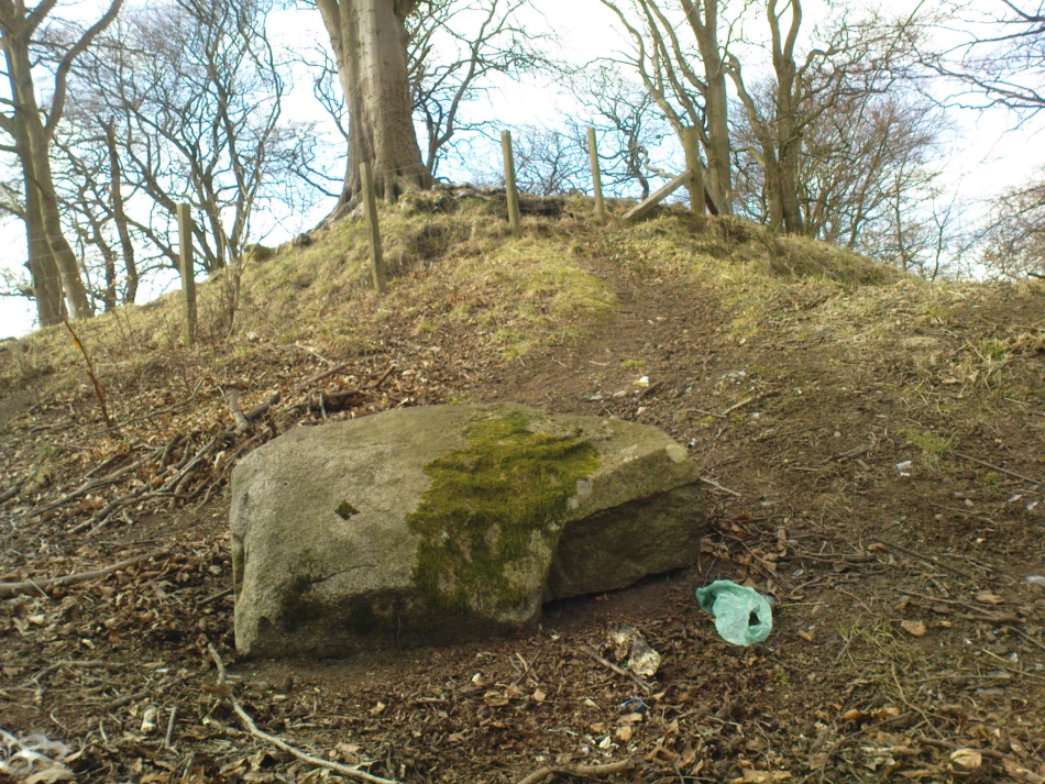
Not too hard to find really. On the far western edge of the King’s Park golf course, head for the highest point where the small cliffs drop down. From here, walk down the footpath on the slight slope south, just below where the small copse of trees are, and you’ll see the singular small flat stone in the grasses near the footpath you’re walking along. If you can’t find it – look around!
Archaeology & History
A little-known but fascinating isolated carving, first described by David Morris at the sixth meeting of the Stirling Natural History and Archaeological Society in 1901. It is found on the western edge of the town, above the rocky edges not far from the pond of St. Thomas’ Well on the far edge of the golf course. Morris’ finding was written up in their fine journal, where he wrote:
“In the King’s Park, about 50 yards east of the cliff where a seat overlooks the Douglas Terrace sand quarry, there is a smooth surface of rock showing through the turf, measuring two-and-half feet by one-and-half feet… On it is a cup-shaped hollow, outside the rim of which is a well-marked hollowed ring, beyond which is another faintly marked, concentric circular groove. The cup-mark measures one-and-a-half inches across; the inner rim of the first circle is 4 inches, and the outer rim is 6 inches in diameter. The outer circle, if complete, would be 9 inches in diameter. The depth of the central hollow is half-an-inch, and of the inner groove fully one-quarter of an inch. The markings are plainly artificial…”
King’s Park CR – central design, pointing to northernmost cup
In good sunlight, it is obvious that the carving is a fine example of a double-ringed cup-and-ring carving – though the outer ring may not be complete. The Scottish Royal Commission lads told that “this rock outcrop bears three cup marks” – one of which has the rings surrounding it. In the first photo here, the southernmost cup-marking is highlighted in the centre of the two shells which were on the rock when we arrived.
However, there’s definitely more to this carving than previous investigations have outlined. It seems that the northernmost cup-mark has a ring and a possible outer-ring. There is also a distinctive linear carving, which at first seems like a primitive triangle, just below the southernmost cup – as we’ve tried illustrating here in the photo which Mikki Potts took. It’s faint, but once you see it, it’s obvious that it’s there. Other faint lines of similar nature also seem apparent near the northernmost cup-marking, but we will have to wait for rubbings and further visits in better light to ascertain the full image on this rock. Well worth checking out if you like your rock art! (can any of you Scottish rock-art fanatics have a closer look at this? – take a rubbing of it and see what other aspects are on this design)
Faint linear carvings on southern end of the rock
One other thing which seemed apparent when we were here: this site has all the geomantic hallmarks of accompanying a burial at some time in the ancient past. Its isolation here is unusual and the carving is only 50 yards from the highest point hereabouts, where you have 360-degree views all round, typifying the position of many prehistoric tombs.* Does anyone know about such features, or have records of any field-name surveys taken, which might confirm or deny this thought? Twouldst be good to know!
References:
Feachem, Richard, Prehistoric Scotland, Batsford: London 1963.
Morris, David B., “Cup and Ring Marked Rock Surface in King’s Park,” in Stirling Natural History & Archaeology Society Transactions, 1900-1901.
Morris, Ronald W.B., The Prehistoric Rock Art of Southern Scotland, BAR 86, Oxford 1981.
Royal Commission on the Ancient and Historical Monuments of Scotland, Stirlingshire – 2 volumes, HMSO: Edinburgh 1963.
Royal Commission on the Ancient & Historical Monuments of Scotland, Archaeological Sites and Monuments of Stirling District, Central Region, Society of Antiquaries of Scotland 1979.
* Since writing the above, thanks the correspondence of Paddybhoy, we’ve learned that there definitely were prehistoric tombs close by; one being just at the bottom of the ridge below the carving, on Douglas Terrace. Records describe several other prehistoric tombs nearby at Birkhill House, the Birkhill Sandpit and Coneypark Nursery. However, I still think it most probable that there were other tombs and more rock art, probably along the edges of King Park, aswell as the Cambusbarron plain. These need locating.