Cnoc Brannan, Glen Artney, Comrie, Perthshire

Standing Stone:  OS Grid Reference – NN 7266 1627

Also Known as:

  1. Brannan Stone

Getting Here

Into the eve of western hills

Make a day out of this one, visiting several old places on the way.  From Comrie take the B827 road to Braco, turning right at the tiny Glen Artney road a half-mile along (easy to miss).  3 miles along, pass the derelict Dalness cottage, you can follow the directions to get to the Mailer Fuar (2) cup-and-ring stone; and from here go up the field past the Mailer Fuar (1) carving, through the gate and follow the fence to your right.  Keep going till your reach the Allt na Drochaide cup-and-ring stone.  From here you’re heading (south) towards the rounded crags of Cnoc Brannan.  It’s boggy as fuck in parts so cautiously zigzag through this section up towards the small grassy rise about 350 yards from the cup-and-ring stone.  You’ll find it!

Archaeology & History

From the old stone, gazing S

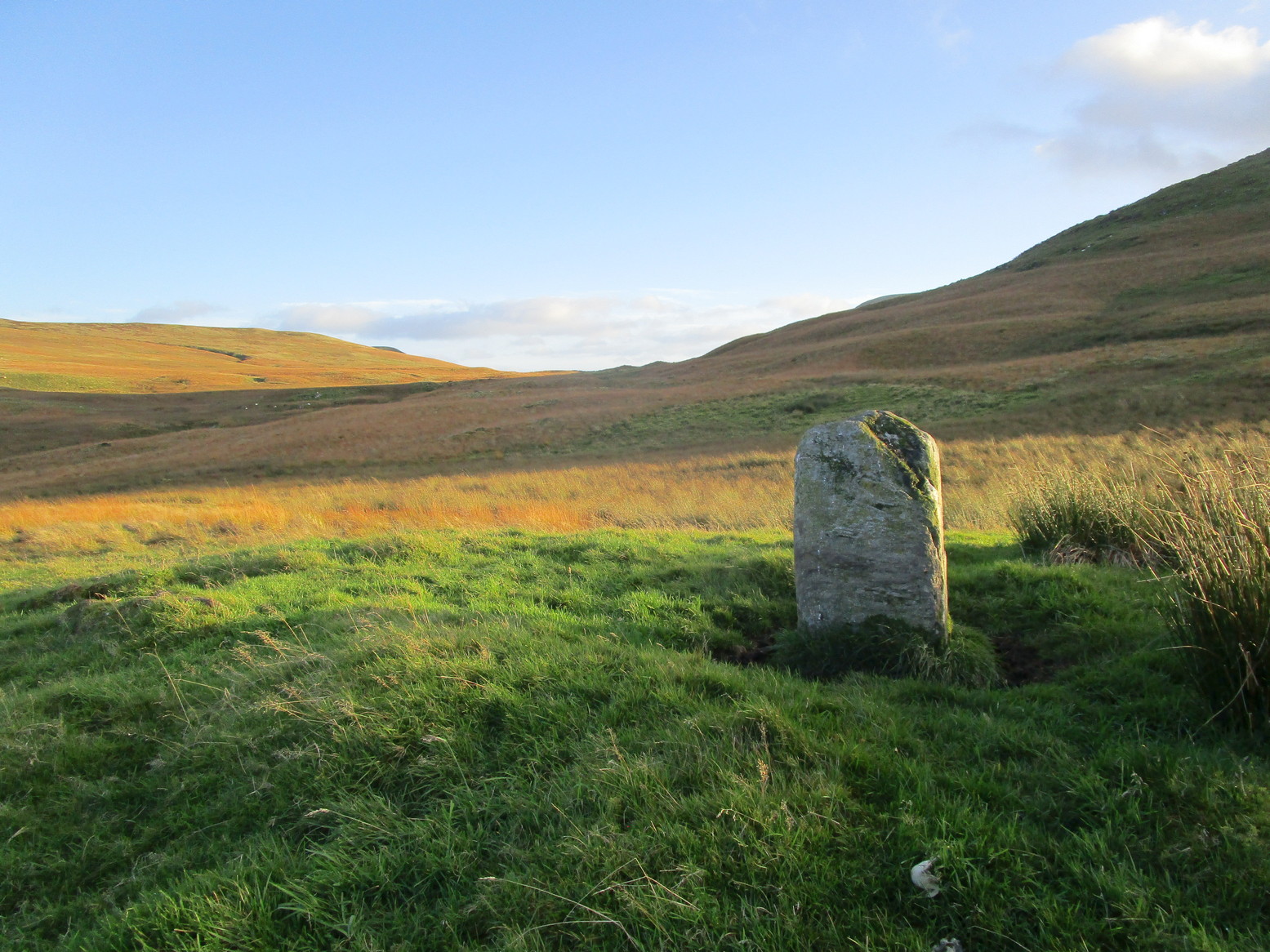
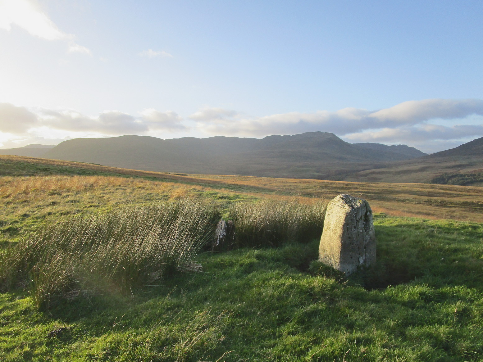
On one of the gentle rises below the northern slope of Cnoc Brannan we find this sturdy old fella, 3-4 feet tall (I didn’t measure it), looking across the stunning landscapes north, east and west along Glen Artney.  Not previously recorded and seemingly isolated from other prehistoric remains, he looks all alone at first sight, but laid down in the grassy rushes (Juncus conglomeratus) to his side, is a slender seven-foot long stone which may have stood upright in the not-too-distant past, giving us another double stone setting in this area (at least two others existed in this area—the closest being at Craggish, 3.7 miles northeast).  I have little doubt that other undiscovered prehistoric remains are hiding in the area. (there are a number of single cup-marked stones in the locale, although I tend to leave such examples off the catalogues as they can be somewhat dubious [and many are].  I mention this just in case any rock art students want to forage the area.)

Dedication: This one’s for Pete & Sharon

© Paul BennettThe Northern Antiquarian

Lauder Common, Lauder, Berwickshire

Cairn:  OS Grid Reference – NT 49340 46162

Getting Here

Modern cairn on the old one

Take the B6362 high road between Lauder and Stow and, regardless of which direction you’re coming from, when you reach the top heights of the moorland road with views all around, you need to keep your eyes peeled for where a dirt-track runs south and, diagonally across the road on its north side, is a dirt-track-cum-parking-spot (if you came from Stow, you should’ve already noticed the cairn on the skyline on your way up).  There’s a hut circle in the heather by the parking spot.  From here, just walk over the heather nearly 300 yards north.  Y’ can’t really miss it.

Archaeology & History

Looking to the southeast

The first thing that you see as you approach here is a modern cairn which is sat upon the more ancient and completely overgrown one.  You can’t really see the “ancient” section of it until you walk round to its more northern side, where you’ll then notice how the new cairn has been built on top of a small but artificial rise in the ground, about ten yards across.  This is the original ancient cairn.  Sections of the ground have come away on its southern side, revealing a scattered mass of loose stones.  It doesn’t seem to have been excavated but has all the hallmarks of being typically Bronze Age by the look of it.  Of particular note is the superb view from here, not least towards the legendary Fairyland of the Eildon Hills, standing out clearly about 10 miles to the south…

© Paul BennettThe Northern Antiquarian

Allt a’ Chaisteil, Bettyhill, Farr, Sutherland

Stone Circle:  OS Grid Reference – NC 7251 5756 

Getting Here

Allt a' Chaisteil 4-poster, Bettyhill

Allt a’ Chaisteil 4-poster remains

From Bettyhill village, take the A836 road west, down the hill from the village. Just before crossing the metal bridge over the River Naver at the bottom, go down the tiny road on the left. A mile or so along, go past the small loch by the roadside for another few hundred yards until you reach a quarry on the right. From here, cross the road and walk along the track towards the impressive Allt a’ Chaisteal Broch up the gorge.  About 100 yards above this, on the south-side of the fence, keep your eyes peeled for two small standing stones. You’ll find ‘em!

Archaeology & History

There seems to be no previous mention of this site in any of the archaeology records.  We were fortunate in venturing upon the place when Aisha, Lara and I were doing a typically circuitous meander to what I call the ‘Queen’s Cairn‘ of Strathnaver, above Skelpick Long.

Allt a' Chaisteil012

The southernmost stones

The site on its raised platform

The site on its raised platform

Approximately 10 yards in diameter, a raised platform 2-3 feet high consisting of thousands of small rocks in a roughly circular formation, is set on the edge of a slope above the Allt a’ Chaisteal Burn.  Two small upright standing stones are set near the southern edge of the platform, with a third on the northwestern bank of rubble, leaning or fallen into the stone mass.  A fourth stone to the northeastern edge is almost covered in rubble.

When we found the site, much of the heather had been burned away; if this had not been done, the site would not have been visible.  Even with this however, accurate visibility was troublesome as the heather had began to grow back and the infestation of bracken was raising its tick-infested fronds.

Close-up of the southern stones

Close-up of the southern stones

The site seems to be a good example of what Aubrey Burl (1988) calls a “four poster stone circle” – a number of which seem to be architectural ritual developments between cairns and stone circles.  It exists within the immense Strathnaver prehistoric complex – a literal ‘Valley of the Kings’ – where dozens of large cairns, and a number of immense megalithic tombs exist. It is very similar in size and lay-out to the recognized four-posters at Druid’s Altar in Yorkshire, the Glenshervie Burn in Glen Almond, etc.  It seems in relative isolation from other four-posters, the nearest known one being at Balnakeil (which Burl terms as being “uncertain”), more than 20 miles west of here; and the next being the Aberscross site some 35 miles away.   However, the remote landscape would explain its seeming isolation, as many more prehistoric sites remain unrecorded in the area.

References:

  1. Burl, Aubrey, Four Posters: Bronze Age Stone Circles of Western Europe, BAR 195: Oxford 1988.

Acknowledgements:  Huge thanks to the big heart of Aisha Domleo – and her sproglett Lara – for gerrin us up here, enabling its rediscovery.

© Paul BennettThe Northern Antiquarian