Once to be seen on the highest point of the island, this impressive 9-foot tall standing stone is thought to have been removed during construction of the old lighthouse around 1833. First described by a traveller here in 1784, it was mentioned just once again during survey work in 1829. The monolith appears to have recorded the midwinter sunset.
References:
Royal Commission on the Ancient & Historical Monuments of Scotland, Argyll – volume 2: Lorn, HMSO: Edinburgh 1975.
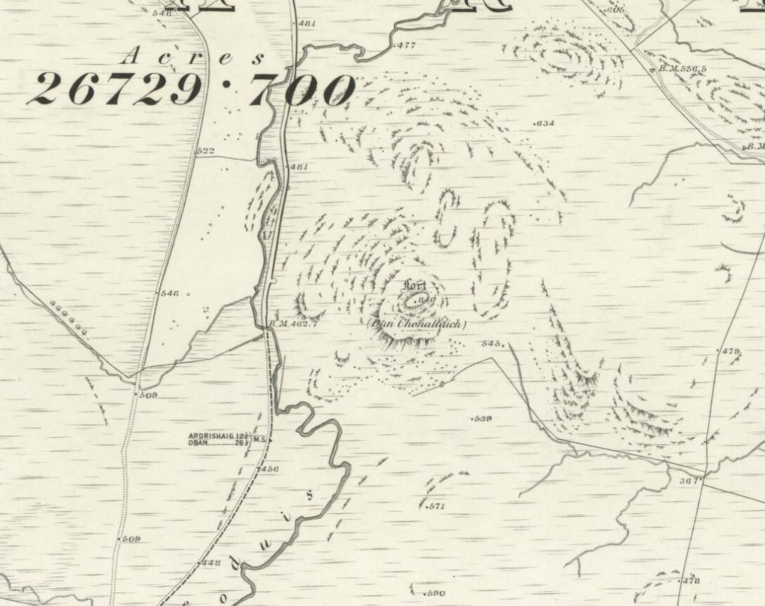
This is a fine-looking monument amidst a fine piece of landscape! The site was constructed over various centuries, beginning in the Iron Age, with the earliest parts being the traces of walling on the outer edges. This first section of the fort “measures about 245m in length by a maximum of 50m in width internally,” and much of it can still be traced all along the full length and breath of the geological ridge upon which it sits. However, the timber-laced walls that stood all round the edges have, obviously, all but disintegrated. This earlier part of the fort, wrote Richard Feacham (1977),
“was superceded by a small subrectangular, now vitrified fort, about 170 feet long by 60 feet wide, and by a circular and probably vitrified dun measuring about 60 feet in diameter.”
View of the Dun (Smith 1885)Looking out from the dun
There was ample water supply for the people who may have lived on this ridged fortress, as there is still a fresh water spring on the southeast edge of the hill. And it seems pretty obvious that this fort was occupied for some considerable time into the Common Era, as material remains found amidst excavation work here at the end of the 19th century, “including metalwork of Roman date…suggests an occupation in the early first millenium AD.” (Harding 1997)
Folklore
The folklore and legends of this site (aswell as the surrounding district) are considerable, and for now I must refrain from writing all there is (it’d take me ages!). Needless to say, R. Angus Smith’s (1885) fine old history and folklore work is the source of much material. Smith told us that,
“There are many stories about it. It has been called the beginning of the kingdom of Scotland, the palace of a long race of kings; also the Halls of Selma, in which Fingal lived; the stately capital of of a Queen Hynde, having towers and halls and much civilization, with a christianity before Ireland; whilst it has also been considered to be that which the native name implies, simply the fort of the sons of Uisnach, who came from Ireland, and whose names are found all over the district, and who in the legend are reported to have come to a wild part of Alban.”
References:
Feacham, Richard, Guide to Prehistoric Scotland, Batsford: London 1977.
Harding, D.W., “Forts, Duns, Brochs and Crannogs,” in The Archaeology of Argyll (edited by Graham Ritchie[Edinburgh University Press 1997]).
Royal Commission on the Ancient & Historical Monuments, Scotland, Argyll- volume 2, HMSO: 1974.
Smith, R. Angus, Loch Etive and the Sons of Uisnach, Alexander Gardner: London & Paisley 1885.
Bittova trek this one. Once on Colonsay, head out onto the B8086 road west of Scalasaig until you, past Machrins, and onto the gold course. Take the footpath across it (south), until you hit the little airstrip where you need to veer right (west) right onto the spur of the coast about 800 yards away. Your damn close!
Archaeology & History
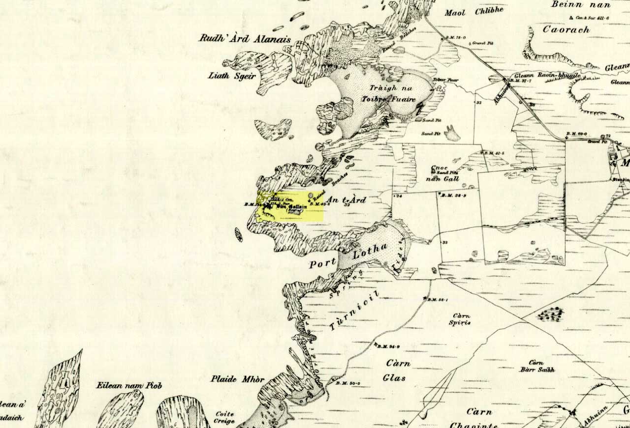
Highlighted on the 1878 OS-map of the region, this site occupies a prominent position. Its summit is surrounded by a line of oval walling enclosing an area of about 90 square yards. There are also remains of of outer walling to the eastern and southern sides. The ‘cairn’ on the highest spot in the middle of the hillfort is a modern construction.
Folklore
The great Scottish folklorist A.A. MacGregor (1947) narrated the tale behind this denuded fort on the western edge of the island. According to the islanders who told him the tale, they alleged it Norwegian in origin, though the fortress is much older than that. MacGregor told that, “in this fort there once lived an elderly and voluptuous tyrant named Grey Somerled, who is said to have been related to the first of the Lords of the Isles.
“Grey Somerled came to Colonsay, they say, in the capacity of factor. But he neglected his duties, imposed penalties and hardships on the innocent and defenceless tenants, and generally made himself so disagreeable that at last it was decided to take revenge upon him, previous warnings having been no deterrent.
“Like Rory Mor of Dunvegan, who slept best when he was within hearing of his ‘nurse’, the waterfall, Grey Somerled was wont to be lulled to sleep by the grinding noise of a quern placed near his head. When he retired for the night, one of the servants had to turn the quern-stone by his pillow, and keep on turning it, lest he woke.
“It was recognised that any attempt to surprise Grey Somerled during daylight was foredoomed to failure. So, a plot was laid to circumvent him during the night-time. His enemies entered into a conspiracy with one of the servants that she should allow them to invade Dun Gallain after he had fallen asleep. When they arrived, one of their number relieved the woman at the quern, and proceeded to turn the stone without intermission. But he was not too skillful at the turning; and his harsh and irregular grinding soon woke the sleeper. Ere Gey Somerled had had time to consider the matter of resistance, his foes were upon him. They carried him away from Dun Gallain; and tradition in the islands of Argyll has it that, in great privation, he spent the remainder of his days in a bee-hive house of stone, situated on the farmlands of Machrins.
“One night – so the story concludes – a huge boulder from the roof of the bee-hive fell in, killing its unhappy inmate. So as to identify the spot where this tragedy happened, the islanders raised on it the cairn now indicated on the Ordnance Survey Map as Carn Shomhairle Liath – that is to say, Grey Somerled’s Cairn.”
Interestingly, there is a long-cist burial at Machrins (plus small settlement) a few hundred yards east of the fort, and excavations here found them to date from the Viking period; though the Scottish Royal Commission thought that although the “small finds associated with the burial suggest that it is Viking, the plan-form of the houses is perhaps more likely to indicate a native tradition.”
References:
MacGregor, Alasdair Alpin, The Peat-Fire Flame, Ettrick Press: Edinburgh 1947.
Royal Commission of Ancient & Historical Monuments, Scotland, Argyll – volume 5, HMSO: Edinburgh 1984.
There’s two real ways to get up here: one from the Oban-Kilmartin roadside; the other from Ford village. I’d go for the latter as it avoids the traffic. Walk up the track to Salachary from the village centre, heading west. It’s a gradual uphill climb and after about half-a-mile (past six or seven cup-marked rocks) the great hill rises to your left. Dun Dubh is to your right. Climb over the fence and head for the hilltop.
Archaeology & History
It’s my opinion that this fort, above all others in the region apart from Dunadd, was of paramount importance to our prehistoric ancestors. The reason being that it’s the great pyramidal hill to which the line of tombs in the Kilmartin Valley align, three miles to the south. This prehistoric alignment was quite intentional (if you’ve got your doubts, gerrup there & have a look for y’self — you’ll soon change yer mind).
Curious carved stone found here
The main part of the structure is an irregularly-shaped construction with walling on all sides, measuring about 40 yards by 20 yards. Much of it is pretty well defined – though has been vandalized by various doods in the past: one bunch being a film-crew who used the site in the early 1980s! Inside the main walled fortress are several ruins. The Royal Commission (1988) report told:
“Much of the interior is occupied by a rock spine which is surmounted by a modern cairn, but the NW half is relatively level and it contains, in addition to the modern round-house…and and an S-shaped structure associated with film-making, a number of ruined stone foundations. On the north side there is a rectilinear building, and between the modern round-house and this rectilinear building, there is a further structure…an arc of walling, but its precise shape cannot now be determined without excavation.”
Dun Chonallaich means “the fort of King Connal’s people,” and although much denuded, is well worth the clamber for a short archaeological day out. A curious “gaming-board” was found here (see photo). A portable cup-marked stone in the fort’s southern wall is a modern artifact.
It’s a lovely view from up here too. This is one of many places I’ve sat during a raging thunderstorm. One helluva buzz, believe me!
References:
Gillies, H. Cameron,The Place-Names of Argyll, David Nutt: London 1906.
Royal Commission for Ancient & Historic Monuments, Scotland, Argyll – volume 6, HMSO 1988.
An old stone-lined burial cist could once be seen in this locale: reported in 1953 to have been “discovered in the southwest corner of a field south of Druimyeonbeg farmhouse.” When it was uncovered by the farmer, the covering capstone was missing. Any relics that may have been there were destroyed and there’s now no trace of anything.
References:
Royal Commission on the Ancient & Historical Monuments of Scotland, Argyll – Volume 1: Kintyre, Glasgow 1971.
Take the A816 south from Oban and after 2 miles at the hamlet of Kilmore, turn left. Follow the road for nearly a mile and as the loch appears ahead of you, stop! The small island crannog is close by the bottom of the loch in front of you.
Archaeology & History
Curiously omitted from the Scottish Royal Commission inventory for Lorn (1974), when R. Angus Smith and his friends explored this artificial island in the 1860s and ’70s, he told:
“it is nearly round, not much larger than a good-sized cottage. It is surrounded by stones large enough to be difficult to lift, and in some places showing themselves to have been put together by art. It would appear as if there had been a pretty firm wall all round – very firm it could not be without mortar or heavier stones. Three or four feet within the range of stones is a raised turf-mound, as if this had been the wall of a house; the centre of the space was rather higher than the rest, and there we expected a fire-place to be found.”
Once they’d got onto the old crannog, Smith and his associates started digging, saying,
“by digging about three feet and a half, the ashes of peat were obtained, bones, charcoal and nuts. A very small hole was made, as we had not then received liberty to dig. We were satisfied that this had been a lake-dwelling, and that it had been defended by a wall. Advantage seems to have been taken of a shallow place, and stones must have been carried to it. It may turn out that there is a wooden foundation. It is not easy to see by what means the covering of earth now over the floor was so much raised. The water of the lake forms little or no deposit in summer; art rather than natural circumstances may have raised the soil. The bones here were split, as at the lake-dwelling in the moss.”
References:
Smith, R. Angus, Loch Etive and the Sons of Uisneach, Alexander Gardner: London 1885.
Dead easy! From Kilmartin go north towards Oban and turn right a mile onwards, to Ford and Loch Awe. Keep on the tiny road for about 2 miles and if you hit the small Loch Ederline, you’ve gone too far. To your left is a small hill-cum-small-mountain, scattered with trees and a great rocky face. That’s it! Whichever way you wanna approach its height is entirely up to you!
Archaeology & History
I clambered up and down this steep ‘crag of the horse’ many-a-times when I lived below here at the old farmhouse at Auchinellan. Tis a grand old hill with good views all round. The hillfort however has little left worth seeing, much of the stone being nicked by locals for drystone walls and barns. The best preserved section seems to be at the northeast side of the old hill. Archaeologists think that the mass of rubble nearby was also part of the fort walls in bygone days. Not being much of a hillfort fanatic, I can’t really comment!
On a decidedly mycological note, the magickal fungus of legendary repute, ergot (Claviceps purpurea), grows like the plague at the bottom of the hill (opposite the Creagantairbh standing stone). I wonder if our ancestors used it for owt in particular…?
References:
Royal Commission on the Ancient & Historic Monuments of Scotland, Argyll – volume 6, HMSO: Edinburgh 1988.
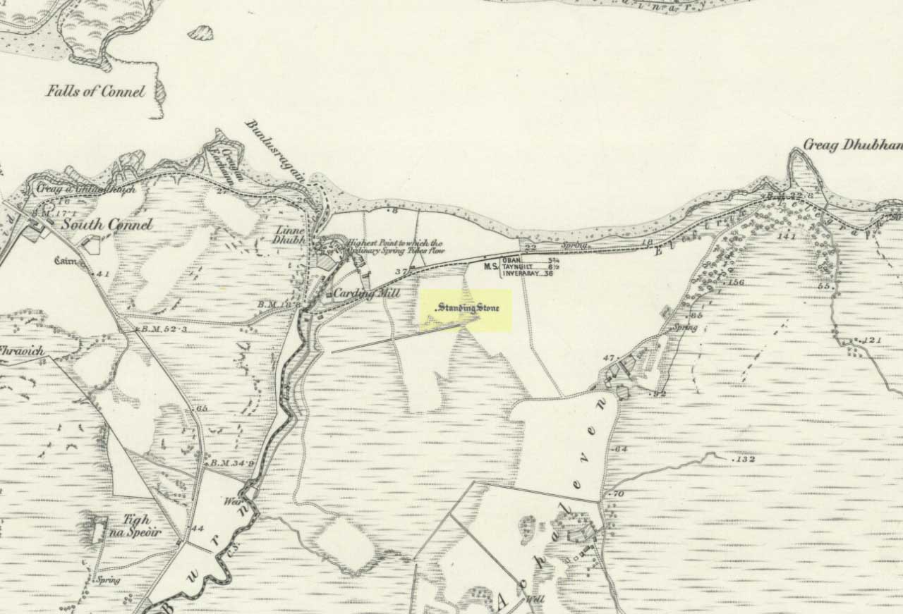
The Royal Commission for Historic Scotland (1974) recorded this “stone that formerly stood within the area now occupied by Connel Station,” which was thought to have been destroyed shortly before construction of the said building. Thankfully the Ordnance Survey lads recorded its position on their cartographic ventures here in 1871. Mr R.A. Smith (1874) also mentioned the site, albeit briefly, in his fine series of essays on the antiquities of Loch Etive, telling us:
“Above Connell Ferry we come to a small brook called Lusragan, and a few houses with a mill called Clachaleven. To the east, in a field above the road, is a large standing stone, and around it marks where others, well remembered, lately stood.”
But sadly it seems, these have all gone.
References:
Royal Commission for Ancient & Historical Monuments, Scotland, Argyll – volume 2: Lorn, HMSO: Edinburgh 1974.
In Thomas Pennant’s A Tour in Scotland and Journey to the Hebrides, 1772 (1790:226), he described there being three prehistoric cairns about four-hundred yards west of Ardminish, or a couple or hundred yards north of the Achamore Standing Stone, on Cnoc na Croise, but they seem to have been destroyed. At least two of them were between 4 and 5 yards across and contained cists. A search for the site by the Royal Commission lads in the 1960s found nothing—although they may have been looking in the wrong place (the grid reference given above is an approximation). Does anyone know anything more about these seemingly lost sites?
References:
Royal Commission for Ancient & Historical Monuments of Scotland, Argyll – volume 1: Kintyre, HMSO 1971.
The Scottish Royal Commission (1971) reported a very large
“standing stone that stood 185m NNW of Achmore House (that) was removed at the beginning of the 19th century. It was reported that is measured 4.9m in height (16ft), 1.2m in breadth and 0.2m in thickness.”
A prehistoric cairn seemed to have accompanied this monolith—as reported by Thomas Pennant in 1772—but it too has been destroyed. Pennant told us how the monolith was,
“a great rude column, sixteen feet high, four broad and eight inches thick.”
Not bad at all! It was still extant, although leaning to the southwest in the year 1790 (OSA 1791-9); appearing to have been removed about 1800. No trace of it remained when the Ordnance Survey lads looked here in 1869.
References:
Royal Commission for Ancient & Historical Monuments of Scotland, Argyll – volume 1: Kintyre, HMSO 1971.
")

")