These are very old (early to mid-neolithic) and very large linear features stretching across the landscape, irrespective of natural obstacles, running (sometimes) dead straight for anything between a few hundred yards to several miles. ‘Alignments’ appear to be one of the primary features of this type of monument, which seem to be related to early long-barrows and tombs. The notion of their relationship with water and death is likely. Modern archaeo-speculation links them with stellar, solar and lunar alignments. They were very likely ceremonial causeways with multifunctional use. The word ‘cursus’ was first used to describe these giant monuments by Will Stukeley in the 17th century – after the notion that they might have been old horse-racing courses; but from Stukeley onwards, very little was said about them (apart from occasional essays in specialist journals) until the late 20th century. Independent archaeologist and psychoanthropology writer, Paul Devereux (1989), wrote one of the first concise surveys of cursus monuments; since then perhaps the best overview has been Roy Loveday’s 2006 work, showing their mythic relationships with death and certain topographical features (ideas propounded by Devereux years earlier).
In Pennick & Devereux’s (1989) early assessment of our enigmatic cursus monuments, he wrote the following brief notes of this particular site:
“The crop marks of another fragmentary cursus were found in Gloucestershire immediately north of Lechlade, to the west of the River Leach. The crop marks aligned northwest-southeast for 174 yards (160 metres) and were 160 feet (50 metres) wide. Only the square northwest end is known. Excavations were carried out in 1965 in advance of gravel workings. No finds were reported, but two out of three cuttings revealed a post-hole on the inside of the ditch.”
References:
Pennick, Nigel & Devereux, Paul, Lines on the Landscape, Hale: London 1989.
Found a few miles south of Banbury and running in a southeast to northwest alignment, Paul Devereux wrote that,
“the crop marks of this cursus fragment were first photographed by James Pickering in 1972…between the villages of East Adderbury and Bodicote…close to the River Cherwell. The southeast end is square; the other terminus is unknown.”
References:
Pennick, Nigel, & Devereux, Paul, Lines on the Landscape, Hale: London 1989.
This minor cursus monument was etched into the landscape in neolithic times. Found to the south of Abingdon and close to the River Thames, one report showed finds from the site dating from 2900 BC. There is also a neolithic henge monument very close to its northern terminus and a plethora of other Bronze Age remains all round. Paul Devereux (1989) described how crop marks revealed,
“a substantial former cursus immediately to the east of Drayton: its crop marks extend southwest to northeast for a little over a mile, and are 225 feet (68 metres) wide. The cursus has a squared south end, but the northern terminus has not been found. The crop marks are not evident in the middle portion of the cursus, as it was formerly overlaid by a Saxon village. There is a plethora of other crop marks within and around the cursus… The northern section…which has a slightly different orientation to the southern segment, points squarely to the ancient heart of Abingdon.”
References:
Ainslie, R. & Wallis, J., ‘Excavations on the Cursus at Drayton, Oxon’, in Oxoniensis 52, 1987.
Barclay, A., Lambrick, G., Moore, J. & Robinson, M., Lines in the Landscape, OAU: Oxford 2003.
Loveday, Roy, Inscribed Across the Landscape, Tempus: Stroud 2006.
Pennick, Nigel & Devereux, Paul, Lines on the Landscape, Hale: London 1989.
Nowadays marked on modern Ordnance Survey maps as part of a ‘Neolithic Sacred Complex,’ this linear monument was part and parcel of the Dorchester Big Rings henge complex and was associated with a number of other important prehistoric sites, many of which have been destroyed by ecological disfigurement projects in recent years. In Gordon Copley’s (1958) description of the monument, not long after its initial discovery, he said that this “was a cursus which consists of parallel ditches some 4000 feet long with 210 feet between them.” In more recent times Paul Devereux (1989) described how the cursus here,
“ran for three-quarters of a mile (1.2km) in a northwest to southeast direction on the north side of the Thames and was 210 feet (64 metres) wide. The cursus was part of a complex of crop marks, the most notable being” the henge. “The northwest end of the cursus remains unknown; the southeast end was rounded. The southeast segment…was on a slightly skew alignment compared to the rest of the feature, though it may have been the earliest part of the monument – bones found there were radio-carbon dated to around 3000 BC. The southern ditch of the cursus ran through and connected two earlier sites which shared a different alignment. Deposits of cremated bones, a stone arrowhead, fragments of pottery, a polished flint axe, and a circle of pits, probably the remains of a ‘woodhenge’ structure, were all found with the cursus.”
Dorchester cursus plan 1985
Jean Cook (1985) told that later excavations on the site in 1981, found that the shallow ditch which surrounded the entire cursus, “was interrupted by a central entrance on the southeast side. The southeastern terminal ditch respected a small prehistoric monument which has been dated to approximately 2000 BC.” This and other factors has led to the thought that the cursus may not all have been built at the same time. And indeed excavations at other sites scattering the northwestern ends of the cursus (shown in the plan here, Ed.) proved that a D-shaped enclosure “pre-dates the rest of the structure.” Other mortuary sites scattered the edges of the cursus that were added in the centuries which followed, but which need excavation work to uncover their secrets. Although much of this was done in the Atkinson digs, they were summarised well by Jean Cook (1985), who told:
“Site VIII, excavated in 1948, was a monument known as a mortuary enclosure. Sometimes such structures take the form of long barrows, but this one was a rectangular enclosure bounded on all four sides by a ditch with an internal bank. There were narrow entrance gaps on the two longer sides and a wider entrance in the centre of the shorter southern side. It is dated by the substantial sherds of Ebbsfleet ware (pottery) which were found in the upper filling of the ditch; part of a human jaw from within the enclosure helps to confirm the mortuary function.
“Site XI, excavated in 1949, consisted of three or more concentric ditches, of different dates, enclosing an incomplete ring of 14 pits. The middle ditch seems to have surrounded an oval barrow or enclosure and to have then been converted to a circular plan. Some of the pits contained animal bones, one contained an antler pick and one contained a complete human cremation, but there were no accompanying grave goods.
“Both these sites were in existence before the cursus was built. (my italics, Ed.) This is shown by the fact that the southernmost ditch of the cursus cuts through Site VIII and abuts Site XI. These two earlier sites seem to share the same alignment, but once the cursus was constructed it set a new alignment which may have been of significance until the end of the 3rd millenium BC. Three monuments built after the construction of the cursus were located inside it, two of them being along the central axis, and two others were just outside the southernmost ditch of the cursus but shared the same general alignment.
“Sites IV, V and VI, which were also excavated in 1949, have a similar overall plan and all of them contained a number of cremation deposits suggesting that amongst other things they acted as cemeteries. All three sites had a circular plan and consisted of an outer bank, to define the central area, and an inner ditch, the purpose of which seems to have been to provide earth for the bank. In Site IV the ditch was made up of eight oval pits, enclosing an area of about six metres in diameter. There was a broad entrance gap on the southeast side. Inside the enclosed area there were 25 deposits of cremated bones. An arrowhead was found with one of the cremations. Site V was very similar in construction, except that the entrance gap was on the northwestern side and contained 21 cremation deposits. No grave goods were found. Site VI again had a similar plan with the entrance gap to the north. There were 49 cremation deposits , one accompanied by a flint fabricator, an arrowhead and burnt flint flakes.
“Site 1 was excavated in 1946 and consisted of a small square ditch, enclosing another more or les circular ditch with an internal bank. Inside this ditch were 13 holes, forming a ring with an entrance gap on the western side. There were no entrances in the surrounding ditches. A crouched burial was found within the entrance to the ring of holes but there were no accompanying grave goods. Four cremations were found, two accompanied by fragmentary bone pins, in or besides four of the central holes. At a later stage in the neolithic period, parts of the ditch may have been enlarged to make temporary shelters: it is not clear to which period of use the cremations belong.
“Site II, also excavated in 1946, consisted of a causewayed (interrupted) ring ditch which was enlarged on two occasions. The third ditch had an internal bank in which were 19 cremation deposits. Two more cremations were found at the centre of the enclosed area. There was no evidence for any gap. Bone pins were found with four of the cremations as were flint fragments. In addition, antlers and other flint fragments were found, as well as pieces of pottery.
“In 1981 a small semi-circular enclosed ditch was excavated within the southeast terminal of the cursus. Though sited off-centre, the ditch shared the same alignment with the cursus. An antler (dated to c.2000 BC) was found close to the bottom of the ditch. After the ditch had virtually filled up with silt, the surviving low central mound was used for cremation deposits, one of them associated with a heavily burnt flint blade.”
Paul Devereux (1989) pointed out how one of the archaeologists studying this site found that if the axis of the monument was extended southeast, across the river, it lined up perfectly with another set of perfectly straight lines which were thought “likely to be a Roman trackway.” Unfortunately much of this area has been destroyed through the self-righteous ignorance of modern industrialism.
References:
Atkinson, R.J.C. et al, Excavations at Dorchester, Oxon, Department of Antiquities: Oxford 1951.
Barclay, A., Lambrick, G., Moore, J. & Robinson, M., Lines in the Landscape, OAU: Oxford 2003.
Cook, Jean, “The Earliest Evidence,” in Dorchester through the Ages, Oxford University 1985.
Cook, Jean & Rowley, Trevor (eds.), Dorchester through the Ages, Oxford University 1985.
Copley, Gordon J., An Archaeology of South-East England, Phoenix House: London 1958.
Loveday, Roy, Inscribed Across the Landscape, Tempus: Stroud 2006.
Pennick, Nigel & Devereux, Paul, Lines on the Landscape, Hale: London 1989.
The Forham All Saints Cursus (image courtesy, Paul Devereux)
Archaeology & History
The remains of this cursus can be found in the valley of the Lark. In Paul Devereux’s (1989) survey of these gigantic neolithic features he described how today we can only see it as crop-markings, stretching in a
“roughly northwest to southeast direction for about a mile; its width approximately 140 feet (42.5 metres). It is comprised of three straight lengths, each at slightly different orientations – there is no way of telling at present (c.1988) whether or not these segments were built at different times, as is believed to be the case at certain other cursuses where changes of direction occur. The northmost terminus has not been located, but the southern one is visible from the air and is next to a circular crop-mark.”
Some 350 yards further on from the end of the cursus is the village church of All Saints, whose old festival date centred around Halloween, or the old pre-christian New Year.
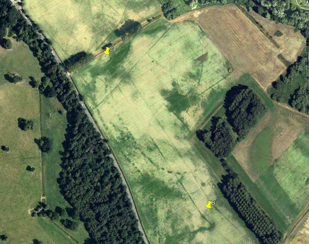
Central section of cursus
Starting at the southern end of the cursus (A), it headed northwest for more than 650 yards (0.6km) before it took its first slight change of direction. Almost all of this first section has been built over by the village; but we can see it in aerial views again on the north side of the village at the edge of the field, at TL 8365 6774 (B). Changing direction slightly, it moves more NNW for another 590 yards (539m) and then kinks again slightly more NNW at TL 8325 6809 (C), before heading onto its final change in direction 464 yards (424m) away at TL 8299 6843 (D). From this point, more recent surveys have shown it to continue further onwards, with another minor alteration in its direction to the north. It goes in a dead straight line for another 336 yards (334.5m), seemingly terminating a short distance before the old Mill Farm at Hengrave, at TL 8291 6876. Just as at the start of the cursus at point ‘A’, where the terminus is curved in a slight arc, so the northern terminus was also curved. The total length of this monument is 1.2 miles (1.9km).
As can be seen in the aerial view (above), a faded double-line of earthworks exists immediately west (left) of the cursus, intersecting and going across the monument. This is the Fornham All Saints causewayed enclosure: another early neolithic monument which may or may not be earlier than the cursus itself.
A curious architectural coincidence (?) can be seen roughly 500 yards west of the central section of the cursus. Running roughly parallel with the prehistoric earthwork is another dead straight avenue leading out, southeast, from Hengrave Hall and, near its terminus, kinks slightly left, just as the cursus monument does about 550 yards away. Fascinating…
References:
Loveday, Roy, Inscribed Across the Landscape, Tempus: Stroud 2006.
Oswald, A., Dyer, C. & Barber, M., The Creation of Monuments, English Heritage: Swindon 2001.
Pennick, N. & Devereux, P., Lines on the Landscape, Robert Hale: London 1989.
Aerial photo of the cursus (courtesy Antiquity journal)
Once to be seen running from the edges of Weston Grange northeast by the canal around Acrelane Bridge, this important mile-long neolithic monument beyond the southern outskirts of Derby has been damaged along much of its length due to the carefree approach of modern industrialists. Found just over 6 miles east of the Potlock or Twyford Cursus, this site was described by J.K. St. Joseph (1964; 1966) in Antiquity journal following an aerial survey of the region on August 7, 1962 — from whence the photograph here was taken, which shows the dead straight monument stretching southwest across the fields. The photo also gives a good idea as to how massive this prehistoric monument actually was! In Mr St. Joseph’s second short essay on this aligned site he told:
Aston Cursus (from Antiquity, 1966)
“The cursus at Aston upon Trent lies at a distance of half a mile from the left bank of the Trent, on gravel overlying New Red Sandstone, at a height of about 120ft O.D., some five miles southeast of Derby. No traces are visible on the surface, but photographs taken over the last few years enable the side-ditches of the cursus to be traced for a length of some 4500ft on a north-east to south-west alignment across six fields: the ditches are parallel and some 325ft apart. Though the entire length has not yet been recorded, the south-west end must lie near the farm of Weston Grange, while the north-east end is a little to the east of the road from Aston upon Trent to Shardlow. The north-western side ditch is interrupted towards the south-west end by two narrow gaps, 500ft apart.
“…Two ring-ditches lying within the cursus perhaps mark ploughed-out barrows. In diameter they measure some 120ft; one of them is defined by a double ditch. There are at least three small ring-ditches, of which one is intersected by the north-west ditch of the cursus. Five small square enclosures lying within the cursus towards its north-east end are less easy to explain. They are not unlike the square ditched enclosures recorded on the Yorkshire Wolds, and there identified as square barrows. About halfway along the length of the cursus a single ditch encloses an irregular area interrupted at two points for an entrance. One end of this area and the north-west ditch of the cursus overlap. Thereabouts, too, the cursus is crossed by elements of a system of linear ditches, which seem to be agricultural divisions of a kind often interpreted in the Middle Thames valley as of Iron Age or Roman date. A similar date is likely enough here, but the question is best left open until some examples have been tested by excavation. Lastly, the “pit-alignment” which extends for some distance towards the (River) Trent is seen to cross the whole width of the cursus, as does a double-line of pits nearer the north-east end…”
More than forty years later and the site is described on English Heritage’s website – at www.pastscape.org.uk, where a few additional aspects of the site are described:
“A cursus monument at Aston Upon Trent, orientated roughly southwest-northeast and located on the gravels of the trent valley, circa 1 kilometre northwest of the present course of the river. The cursus appears to be a regular rectangle, the long sides parallel and circa 100 metres apart. The southwest terminal is straight, and meets both sides at right angles. The northeast terminal has not been recorded as a cropmark, but may well have lain in an area which has been quarried away. If so, the cursus would have originally been a little over 1.5 kilometres in length.
“The cursus ditch was sectioned in the mid-1960s by D. Reaney, though no finds were made. The recorded stratigraphy suggested an internal bank. Further small-scale excavation occurred in 1986 at a point where the cursus ditch appeared to intersect with a ring ditch (SK 42 NW 59), towards the cursus’ south-western end. The cursus ditch appeared to run into and cut the ring ditch, and was therefore later in date. The slightness of the ring ditch and the nature of its fill suggests that there is unlikely to have been a mound of any substantial nature in its interior. Finds were few, and none from primary contexts. They comprised a thumb nail scraper, another worked flint, and a few sherds of pottery, identifiable as Grimston and Beaker ware.
“Adjacent to the ring ditch is another, not excavated, but also contained within the cursus. In 1995, an existing field drain alongside Acre Lane (in the area circa SK 4244 2968) was enlarged as part of work associated with construction of the Derby Southern Bypass.
“The sides of the drain were recorded archaeologically. The western cursus ditch was not present, suggesting the existence of a gap or causeway. The eastern cursus ditch, though not visible on air photographs at this point, was located. Pollen samples were collected, and a fragment of waterlogged wood is to be used for radiocarbon dating.”
The site has since been found to be at least 1700 metres (5610 yards) long, with its northeastern end, or terminus, still undiscovered. It was described by Loveday (2006) as being, “overlain at its mid-point by a tangle of fields and trackways of presumed Iron Age date.” One prehistoric track crosses the cursus at a right-angle then turns 90° just as it crosses the dead straight alignment, running parallel with the cursus ditch for some 300 yards. (see illustration below)
References:
Gibson, A.M. & Loveday, Roy, ‘Excavations at the Cursus Monument on Aston-upon-Trent, Derbyshire,’ in A.M. Gibson’s Midlands Prehistory, BAR 204: Oxford 1989.
Loveday, Roy, Inscribed Across the Landscape, Tempus: Stroud 2006.
St. Joseph, J.K., “Air Reconnaissance: Recent Results, 6,” in Antiquity, volume XL, no.157, March 1966.
Aston Cursus, with overlying Iron Age tracks & fields (after Loveday 2003)