From Bettyhill village, take the A836 road west, down the hill from the village. Just before crossing the metal bridge over the River Naver at the bottom, go down the tiny road on the left. A mile or so along, go past the small loch by the roadside for another few hundred yards until you reach a quarry on the right. From here, cross the road and walk along the track towards the impressive Allt a’ Chaisteal Broch up the gorge. About 100 yards above this, on the south-side of the fence, keep your eyes peeled for two small standing stones. You’ll find ‘em!
Archaeology & History
There seems to be no previous mention of this site in any of the archaeology records. We were fortunate in venturing upon the place when Aisha, Lara and I were doing a typically circuitous meander to what I call the ‘Queen’s Cairn‘ of Strathnaver, above Skelpick Long.
The southernmost stones
The site on its raised platform
Approximately 10 yards in diameter, a raised platform 2-3 feet high consisting of thousands of small rocks in a roughly circular formation, is set on the edge of a slope above the Allt a’ Chaisteal Burn. Two small upright standing stones are set near the southern edge of the platform, with a third on the northwestern bank of rubble, leaning or fallen into the stone mass. A fourth stone to the northeastern edge is almost covered in rubble.
When we found the site, much of the heather had been burned away; if this had not been done, the site would not have been visible. Even with this however, accurate visibility was troublesome as the heather had began to grow back and the infestation of bracken was raising its tick-infested fronds.
Close-up of the southern stones
The site seems to be a good example of what Aubrey Burl (1988) calls a “four poster stone circle” – a number of which seem to be architectural ritual developments between cairns and stone circles. It exists within the immense Strathnaver prehistoric complex – a literal ‘Valley of the Kings’ – where dozens of large cairns, and a number of immense megalithic tombs exist. It is very similar in size and lay-out to the recognized four-posters at Druid’s Altar in Yorkshire, the Glenshervie Burn in Glen Almond, etc. It seems in relative isolation from other four-posters, the nearest known one being at Balnakeil (which Burl terms as being “uncertain”), more than 20 miles west of here; and the next being the Aberscross site some 35 miles away. However, the remote landscape would explain its seeming isolation, as many more prehistoric sites remain unrecorded in the area.
References:
Burl, Aubrey, Four Posters: Bronze Age Stone Circles of Western Europe, BAR 195: Oxford 1988.
Acknowledgements: Huge thanks to the big heart of Aisha Domleo – and her sproglett Lara – for gerrin us up here, enabling its rediscovery.
From the main road running through lovely Comrie, take the south B827 road over the old river bridge. Go dead straight for several hundred yards until the road bends right; but take the left turn here. 100 yards or so along note the trees on your right, and the road begins to swerve round here. Just round the corner in the trees, the stones are in the clearing right by the roadside. You can’t miss them! (if you hit the graveyard, you’ve gone past them)
Archaeology & History
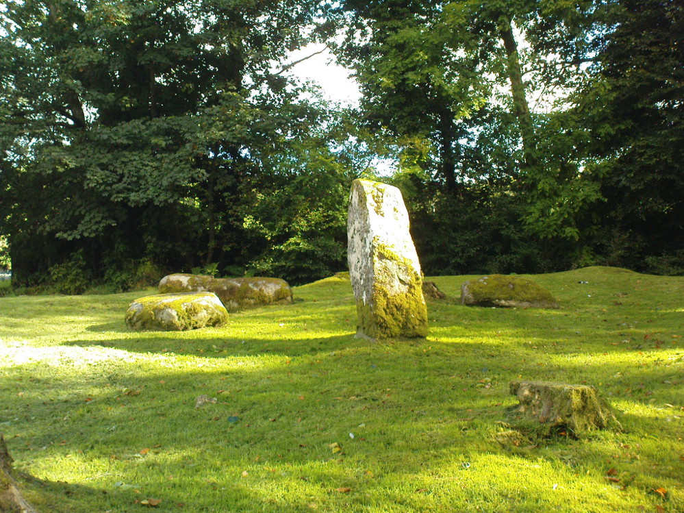
This is a truly lovely, almost warming enclosed megalithic site—albeit damaged by the ruin of centuries; but on the occasions I’ve been here it feels quite nurturing and elicits a quite natural meditative state. Whether or not this is due to the surround of trees, or the natural electromagnetic field, or just me, I dunno….
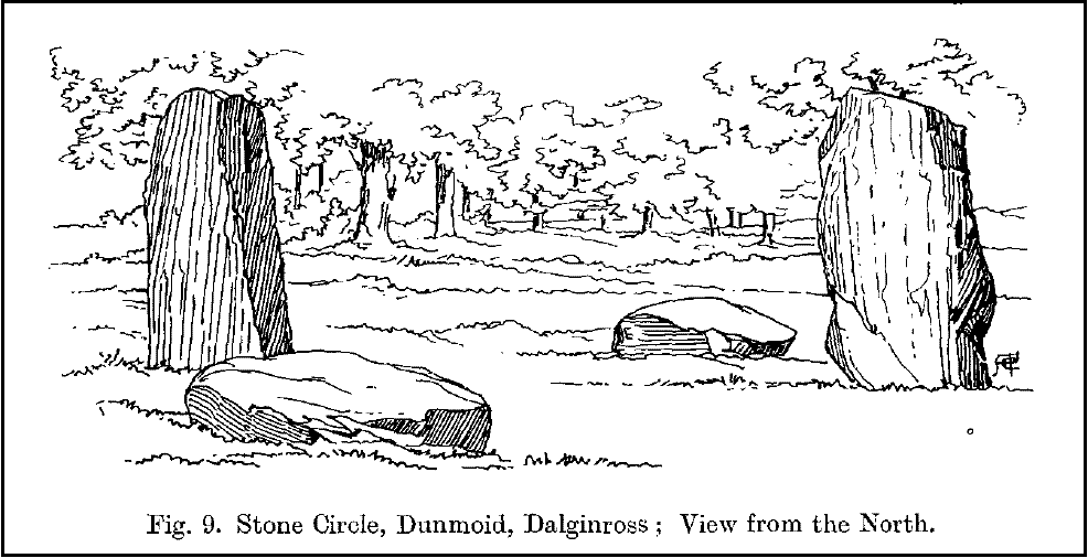
Dunmoid Circle, looking SEDunmoid from the North (Coles 1911)
The ‘circle’ is constructed upon a flat rounded section of ground, surrounded by a ditch on two-thirds of its edges, very reminiscent of a typical henge monument—but there is no mention of this in modern surveys. One of the earliest accounts of Dunmoid was written by John MacPherson (1896) who gave us as much of the known history of the site as is still known by any modern academic. He wrote:
“At the west side of the new cemetery, close to the public road, there is a curious round knoll, which at one time must have been used as a place for the burial of the dead. The attention of the writer of this was drawn to it about twenty years ago. There were three large slabs of stone lying upon the ground, which apparently had been at some former period placed erect by some loving hands to mark the last resting-place of some departed friend or hero. By the aid of some of the Comrie masons the stones were placed in a standing position. Curious to know what lay beneath the surface, we dug up the earth in front of the largest slab, and came upon a stone cist placed north and south, 7 inches long, 1 foot 8 inches broad, and 1 foot 3 inches deep. The only remains discovered was a thigh-bone, but whether it at one time formed a part of the leg of a Celt, a Roman, or a Saxon we could not tell. An old man who then lived in the village of Comrie told us that in his young days the same mound was dug up, when an urn filled with ashes was discovered. This, perhaps, would indicate that it formed a place of burial for Romans rather than for Caledonians. The spot is called Dunmoid, or ‘hill of judgment.'”
Fred Coles 1991 planDunmoid from SE (Coles 1911)
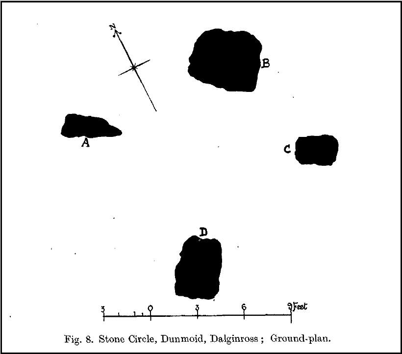
The circle gained the attention of the prolific Fred Coles (1911) in his Perthshire surveys, whose drawings and measurements are still repeated in the modern textbooks more than a century later. When he visited the site, two of the stones were still upright, but today only one still stands. In Aubrey Burl’s (1988) survey on ‘four-poster’ stone circles, he reiterated Coles’ words, telling:
“Originally four stone stood at the corners of a rectangle on a mound some 75ft (23m) across and 2ft (60cm) high. Coles’ plan showed the NW stone standing 5ft 4ins (1.6m) high and the SE, opposite, 5ft 2ins (1.6m), with the thick NW stone prostrate, 4ft 6ins (1.4m) long, with the more slender SW pillar also supine and 4ft (1.2m) long. The longer SE and NW sides of the oblong were roughly 9ft 6ins (2.9m) long and the others 9ft (2.7m) in length. The circle on which the stones had been placed had a diameter 13ft 2ins (4m), of which the Megalithic Yard is not an integer.”
The circle is included in Andrew Finlayson’s (2010) modern survey of the region.
References:
Burl, Aubrey, Four Posters: Bronze Age Stone Circles of Western Europe, BAR 195: Oxford 1988.
Finlayson, Andrew, The Stones of Strathearn, One Tree Island: Comrie 2010.
Hunter, John (Ed.), Chronicles of Strathearn, David Philips: Crieff 1896.
Hutchison, A.F., “The Standing Stones of Stirling District,” in The Stirling Antiquary, volume 1, 1893.
MacPherson, John, “At the Head of Strathearn,” in Chronicles of Strathearn, Crieff 1896.
Balbirnie stone circle – with Marion checking it out!
Take the A92 road running north out of Glenrothes towards Freuchie and, after a couple of miles out of town, you’ll hit the B969 road on your left. Across from here on the other side of the road, you’ve just passed a small B-road that takes you to Markinch. That’s where you need to be! Go along there for less than 100 yards and turn first right, swerving along the tree-lined road for 200 yards or so. Watch out, just before the first house on your left, for a footpath which leads into the woods. Walk down it, barely 10 yards!
Archaeology & History
This is a lovely megalithic ring in a lovely setting – albeit a new one. The circle was originally positioned some 125 yards northwest of here and would have been destroyed, but was thankfully reconstructed by Fife Council before road-widening of the A92 was done. And the job’s a good one! But as Burl (2005) tells, this wasn’t the first time Balbirnie had been threatened with damage:
The southeast stones & cistsBalbirnie from the roadside, looking SE
“With some stones removed in the eighteenth century, dug into in 1883 when bones and sherds were found, damaged by trees, it was finally excavated and restored in 1970-71,” before the main road was built. Thankfully it’s still here – and an excellent stone circle it is! However, the reconstructed site here doesn’t show the circle in its entirety. Originally there were ten standing stones making up the ring, as opposed to the seven you can see today.
The site was built amidst the scatter of other larger, and once more impressive, mythically important monuments than the circle – but it’s as likely that the circle added more to the sacred dimensions of the region as a whole when it first came to be built. For on the other side of the A92 we can still see the denuded remains of the Balfarg Riding School Henge, with imitations of its internal upright posts resurrected into position to give an idea of what once stood inside the sacred enclosure. And then about 200 yards west of that, the gigantic Balfarg Henge is impressively surrounded by a modern housing estate, built with the henge in mind, with its outlying megaliths and internal level surface area graciously intact. It’s a truly impressive prehistoric area all round, although the Balbirnie stone circle was built some considerable time after the two henges had been done, many centuries later…
Before the circle was moved, the consensus profile of the site was that given by the Royal Commission (1933) lads following their visit here in June 1925, when they told it looked like this:
Royal Commission ground-plan, c.1933
“At the southern end of a small wood on the east side of the main road from Kirkcaldy to Falkland, about 180 yards south of Balbirnie Lodge, are the remains of a large circular cairn and of the setting of standing stones by which it was once surrounded… The circle, which has had a diameter of some 48 feet, has been composed of sandstone boulders. Four of these are still in place, but one other on the southeast has been slightly displaced, while against the stone on the northeast lie two large boulders, which apparently have been transferred to this position. Any other stones that may once have existed have been removed or destroyed. The greatest height above ground of any of those that survive is 5 feet 6 inches, while one, which rises no more than 2 feet, measures in circumference as much as 9 feet 9 inches at the base. The cairn itself seems to have been broken into at two points. No record of these excavations appears to be extant, but a number of fragments of cinerary urns from the site are preserved in the National Museum. These indicate that, as might have been inferred from its general character, the monument was sepulchral and dates from the Bronze Age.”
Sepulchral indeed. When the stone circle was excavated at the beginning of the 1970s by J.N.G. Ritchie (1974) and his mates, it was discovered this was a primary function of the site. As Burl (2000) wrote:
“At Balbirnie patches of cremated bone lay underneath some circle-stones. Whatever the ceremonies here they were interrupted when the site was converted into a cemetery. Four or five cists associated with a late beaker and a jet button were constructed within the ring. The date of about 1650 BC came from wood alongside the beaker. Stretches of low walling were put up between the stones forming a continuous barrier…analogous to the embanked stone circles elsewhere in Britain that seem generally to belong to a period in the mid-second millennium… But the first cists did not long remain undisturbed and were seemingly rifled when later cists were built that contained the cremations of women and children… One of these later cists held a food-vessel and a flint knife.
“The stone circle was further abused. A low cairn was piled over all the cists. Sherds of deliberately broken urns, one with barley impressions, were scattered amongst the boulders, intermingled with small coagulations of burnt human bone. This last phase at Balbirnie occurred late in the second millennium BC, for a C-14 determination of…1200 to 900 BC came from the land surface that had built up within the ring during the centuries while the stone circle remained open to the weather.”
Measuring 49 feet across at the widest, this flattened ellipse also possessed a curious rectangular section of laid stone, near the middle of this circle, almost ‘Roman-road’ like in appearance and covering about a quarter of the internal arena. It’s visible today at the reconstructed site and looks almost intrusive! Measuring some 11 feet by 9 feet, the flat stone surface has been suggested as a place where corpses were rested.
Also found within two of the tombs inside the circle were the cup-and-ring marked stones of Balbirnie 1 and Balbirnie 2, showing yet again the relationship that some of these carvings have with spirits of the dead.
References:
Burl, Aubrey, “Intimations of Numeracy in the Neolithic and Bronze Age Societies of the British Isles (c.3200-1200 BC),” in Archaeological Journal, volume 133, 1976.
Burl, Aubrey, Rings of Stone, BCA: London 1979.
Burl, Aubrey, The Stone Circles of Britain, Ireland and Brittany, Yale University Press 2000.
Burl, Aubrey, A Guide to the Stone Circles of Britain, Ireland and Brittany, Yale University Press 2005.
Denston, C.B., “The Cremated Remains from Balbirnie, Fife,” in Archaeological Journal, volume 131, 1974.
Ritchie, J.N.G., “Excavation of the Stone Circle and Cairn at Balbirnie, Fife,” in Archaeological Journal, volume 131, 1974.
Royal Commission on the Ancient & Historical Monuments, Scotland, Inventory of Monuments and Constructions in the Counties of Fife, Kinross and Clackmannan, HMSO: Edinburgh 1933.
Acknowledgements: Huge thanks to Marion Woolley for getting us out to see this and the related neolithic monuments. Cheers m’ dears!
The isle of Boreray is four miles northeast of Hirta and here once lived, according to legend, a christian hermit. However in the reverend Kenneth Macaulay History of St. Kilda (1764), he told us that the character was actually a druid. Take your pick! The druid lived at Stallir House, adjacent to which, said Macaulay, was
“a large circle of huge stones fixed perpendicularly in the ground, at equal distances from one and other, with one more remarkable regular in the centre which is flat in the top and one would think sacred in a more eminent degree.”
In a later article by F.L.W. Thomas (1867) he also mentioned this ‘stone circle’, though indicated its decline. Additional information on this little known stone is sparse due to its somewhat remote position on one of the uninhabited isles of St. Kilda. I wouldn’t mind spending a month or two there, roughing it, to see what’s what!
References:
Macaulay, Kenneth, The History of St. Kilda. Containing a Description of This Remarkable Island; the Manners and Customs of the Inhabitants; the Religious and Pagan Antiquities There Found, T. Becket: London 1764.
Stone Circle (destroyed): OS Grid Reference – NS 9256 9709
Also Known as:
Druidical Temple
Archaeology & History
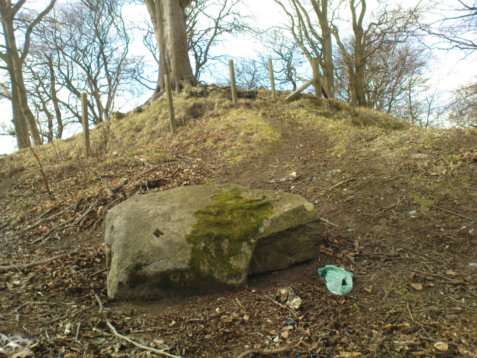
A stone circle was once to be found on the elevated piece of ground above the north-side of the main road between Tillicoultry and Dollar, but it was sadly destroyed sometime in the 19th century. Listed in Aubrey Burl’s (2000) magnum opus, we have very little information about the place; though an account of the site was described in the Scottish Royal Commission report (1933) which told us that a —
“Stone circle, measuring about 60 feet in diameter, once stood here but was completely removed many years ago, when the stones, which are said to have been 5½ feet in average height, were taken to cover a built drain at Tillicoultry House”!
Site shown on 1866 OS-mapStone at the destroyed site
Unbelievable! Any decent local folk nearby wanna find out where this drain is, see if the stones are visible (though I doubt they are), so we can plan to uproot it and move the stones back somewhere nearby. There are a few decent spots on the slopes above where it would look good!
When visited by researchers in the 1890s, parts of an embankment which surrounded the destroyed circle were still visible. Also, indicating there was some ritual funerary nature to the site, a local teacher called Mr Christie found the remains of an ornamented urn protruding through the ground next to where one of the monoliths had stood. Unfortunately in his attempts to remove the urn, much of it crumbled away.
Further examinations thereafter found that a burial was (seemingly) beneath the centre of the circle; and excavations here found that a covering stone of the tomb was covered in intricate cup-and-ring designs (see the Tillicoultry House Carving for further details). Other prehistoric remains were found a little further up the hill from here.
References:
Burl, Aubrey, The Stone Circles of Britain, Ireland and Brittany, Yale University Press 2000.
Morris, Ronald W.B., The Prehistoric Rock Art of Southern Scotland, BAR 86: Oxford 1981.
Robertson, R., ‘Notice of the Discovery of a Stone Cist and Urns at the Cuninghar, Tillicoultry…’, in PSAS 29, 1895.
Royal Commission on the Ancient & Historical Monuments of Scotland, Fife, Kinross and Clackmannan, HMSO: Edinburgh 1933.