Elistoun West, Tillicoultry, Clackmannanshire

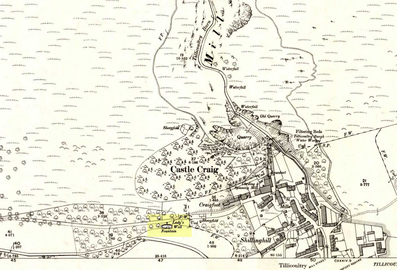
Cairn:  OS Grid Reference – NS 92220 99205

Also Known as:

  1. Canmore ID 48266
  2. Eliston Hill

Getting Here

Cairn, with Gannel Hill in the background

A helluva climb to get here.  Take the last road up towards Mill Burn at the west end of Tillicoultry and go to the picnic area & carpark, just below the footpath that takes you up the eastern slopes of the gorge.  Walk up and up the steep footpath for nearly a mile and, as the landscape begins to level out a bit and turns more into a slope, watch out for a split in the paths and make sure you hit the one that veers you to the right, towards King’s Seat instead of the one that runs alongside the edge of the Gannel Burn valley below you.  Walk along this path for a few hundred yards and you’ll come across a large pile of rocks placed atop of a much older and overgrown mass of stones, right by the path side. .

Archaeology & History

View of the green cairn, looking north

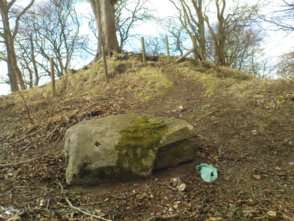
Due northwest of the curiously named Elistoun Hill, is this seemingly isolated overgrown prehistoric cairn.  Measuring some 8 yards across and more than a yard tall, this compacted fairy-mound of a hillock has the crown of many large, more recent blocks on top, thankfully highlighting it making it much easier to find!  But its isolation here is truly curious – as is the location halfway along hillside, quietly hidden away, calling out for no attention to any ancient traveller.  It was listed as an ancient monument when surveyed by Ordnance Survey in the 1970s, although I have to be honest in saying that I doubt the prehistoric prevenance of the site.  I may be wrong, but an excavation here would prove worthwhile.

© Paul Bennett, The Northern Antiquarian


St. Serf’s Well, Alva, Clackmannanshire

Holy Well:  OS Grid Reference – NS 8885 9722

Also Known as:

  1. St. Servanus’ Well

Getting Here

St Serfs Well, hidden in deep grasses

Along the main street running through Alva, towards Tillicoultry, watch out for the roman catholic church on your left, then shortly past it the house of St. Serfs.  Just next to this is the small road called Lovers Loan. Walk up here and just before the graveyard, walk right, into the overgrown boggy marshlands.  The first presence of the holy waters here are about 12-15 yards into the grasses, where you’ll walk right into it!

Archaeology & History

A sacred well that was named after the little known character of St. Serf, who was said to have been the hermit and tutor of the more renowned St. Mungo.

Highlighted on the 1866 Ordnance Survey map of the area as St. Servanus’ Well, 100 yards southeast of the church, it was included in MacKinlay’s (1893) fine survey, though without comment.  However it was said by Mr & Mrs Morris (1982) to be “near the south entrance of the churchyard.”   The boggy remains of the spring can indeed be found at the southern edge of the graveyard, up Lovers Loan, just below the edges of a large mound.  In Mrs Drummond’s (1936) survey of Alva, she too told that the “Well of St Servanus”,

“contained healing waters and was still to be seen in St. Serf’s Glebe in 1845, nbut it is now just a marsh on the west wisde of the lower cemetrary gate.”

The original waters have in fact been completely capped and the well is now covered by a modern concrete block, standing right next to the resurrected remains of one of Alva’s remaining standing stones.

References:

  1. Drummond, Mrs A., The History of Alva and District from the Early Christian Period to 1900, in Transactions Stirling Natural History & Antiquarian Society, volume 58, 1936 (reprinted by Clackmannan District Libraries 1981).
  2. MacKinlay, James M., Folklore of Scottish Lochs and Springs, William Hodge: Glasgow 1893.
  3. Morris, Ruth & Frank, Scottish Healing Wells, Alethea Press: Sandy 1982.

© Paul Bennett, The Northern Antiquarian


Lady’s Well, Tillicoultry, Clackmannanshire

Holy Well:  OS Grid Reference – NS 91105 97510

Also Known as:

  1. Ladies Well
  2. Our Lady’s Well

Getting Here

The old spring of Lady’s Well

From the main road running through the town, head west towards Alva, and where the golf course begins, take the footpath uphill at its edge which heads towards the giant quarry.  Where the dirt-track begins, keep walking along the edge of golf course, noting that where the open field starts, a gate on your right.  Go through this, and walk up the side of the fence for some 30 yards, then go through the large gate.  10 yards in front of you, note the small stream crossing the track, and a scatter of overgrown rocks just on the other side of the wire fence. You’re here!

Archaeology & History

Thought by Angus Watson (1995) to have been possibly dedicated to ‘Our Lady’: in this context it’s difficult to know whether the dedication was to the christian Virgin, or to the heathen ‘Lady Alva’, whose web of snow and other natural garments clothe the mountains and glens of the Ochils hereby.

The first account of the place seems to be in William Gibson’s Reminiscences (1883) where he told that,

“In the year 1839, a Mr John Henderson built the only woollen mill…the water for the steam engine of which was got from the Ladies Well”,

Ladys Well on 1899 map

which was barely 100 yards to the west.  It was later highlighted on the OS-map in 1899 with an associated ‘fountain’, right by the track-side.  A water-pumping station shown at the same time on another map was, of course, the one that was built to supply the mill with water.

The present water source is slightly higher in the field than when it was shown on the early OS-maps, and it does still flow continuously—although the source is much neglected and could do with being recovered: as the photo here shows, an ugly pipe appears to be taking much of the healing waters which are now mainly feeding a large pond in the garden just below.

References:

  1. Gibson, William, Reminiscences of Dollar and Tillicoultry, Andrew Elliot: Edinburgh 1883.
  2. Watson, Angus, The Ochils: Placenames, History, Tradition, Perth & Kinross Libraries 1995.

© Paul Bennett, The Northern Antiquarian


Cunninghar, Tillicoultry, Clackmannanshire

Stone Circle (destroyed):  OS Grid Reference – NS 9256 9709

Also Known as:

  1. Druidical Temple

Archaeology & History

Remaining stone at the destroyed circle

A stone circle was once to be found on the elevated piece of ground above the north-side of the main road between Tillicoultry and Dollar, but it was sadly destroyed sometime in the 19th century.  Listed in Burl’s (2000) magnum opus, we have very little information about the place; though an account of the site was described in the Scottish Royal Commission report (1933) which told that a —

“Stone circle, measuring about 60 feet in diameter, once stood here but was completely removed many years ago, when the stones, which are said to have been 5½ feet in average height, were taken to cover a built drain at Tillicoultry House”!

Stone circle site shown on the 1866 OS-map

Unbelievable!  Any decent local folk nearby wanna find out where this drain is, see if the stones are visible (though I doubt they are), so we can plan to uproot it and move the stones back somewhere nearby. There are a few decent spots on the slopes above where it would look good!

When visited by researchers in the 1890s, parts of an embankment which surrounded the destroyed circle were still visible.  Also, indicating there was some ritual funerary nature to the site, a local teacher called Mr Christie found the remains of an ornamented urn protruding through the ground next to where one of the monoliths had stood.  Unfortunately in his attempts to remove the urn, much of it crumbled away.

Further examinations thereafter found that a burial was (seemingly) beneath the centre of the circle; and excavations here found that a covering stone of the tomb was covered in intricate cup-and-ring designs (see the Tillicoultry House Carving for further details).  Other prehistoric remains were found a little further up the hill from here.

References:

  1. Burl, Aubrey, The Stone Circles of Britain, Ireland and Brittany, Yale University Press 2000.
  2. Morris, Ronald W.B., The Prehistoric Rock Art of Southern Scotland, BAR 86: Oxford 1981.
  3. Robertson, R., ‘Notice of the Discovery of a Stone Cist and Urns at the Cuninghar, Tillicoultry…’, in PSAS 29, 1895.
  4. Royal Commission on the Ancient & Historical Monuments of Scotland, Fife, Kinross and Clackmannan, HMSO: Edinburgh 1933.

© Paul BennettThe Northern Antiquarian