St. Mungo’s Well, Glasgow Cathedral, Lanarkshire

Holy Well:  OS Grid Reference – NS 6025 6558

Archaeology & History

St Mungos Well, Glasgow cathedral

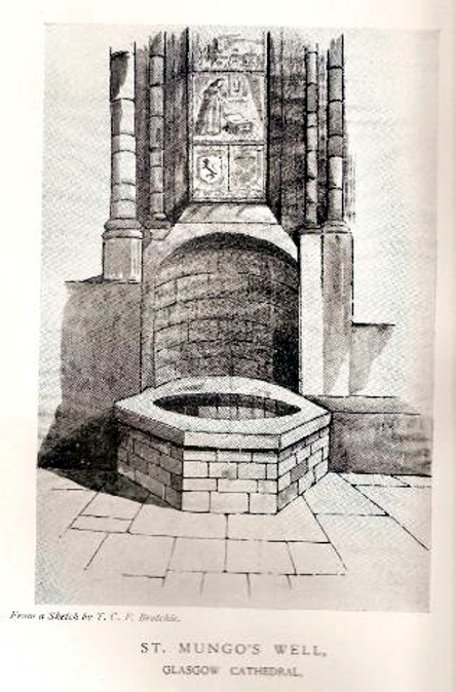
Not to be confused with the sacred well of the same name found along Gallowgate a short distance to the south, the waters of this ancient well have sadly fallen back to Earth.  The structure built above it, however, is thankfully still preserved inside the Cathedral, as visitors will see.

Folklore and history accounts tell its dedication to be very early – and the tale behind the erection of the cathedral is closely associated with the waters themselves.  Indeed, if the folklore is accepted, we find merely a transference of early animistic ideas about the death of an ancestor placed onto this early Saint, with a simple association in the formula of:  tomb, holy site and architectural form.  It could almost be Bronze Age in nature!

The lengthiest (and best) description of St Mungo’s Well was by Mr Brotchie (1920) in a lecture he gave on the city’s holy wells in April 1920, which was thankfully transcribed by the local history society.  He told us:

“It seems to me that Glasgow in a very particular degree is a case that illustrates emphatically the existence of the early cult of the sacred fountain (sketch attached)… How came it to be there? In itself it represents the very beginning of Glasgow.  It was to the little spring on the hillside overlooking the Molendinar that there came the earliest of christian missionaries, Ninian. All that we know of Ninian is from the account of Jocelin, the monk of Furness, who tells us that “ane holy man Ninian cam to Gleschu or Glasgow in the third century”, and made his cell on the banks of the Molendinar. When Kentigern or Mungo came to Glasgow in the sixth century, he made his settlement near a certain cemetery, which had long before been consecrated by St. Ninian, and which at the time when Jocelin wrote (twelfth century), was “encircled by a delicious density of overshadowing trees.”  The crypt of the Cathedral—in reality an under church of extraordinary beauty of design and magnificence of mason work—is the shrine of St. Mungo, who is buried there, and the whole design of the lower church shows that the architect who in 1230 planned the building…built his scheme up with the idea of providing a shrine for the saint’s tomb and his holy well.

“The well is in the lower eastern corner of the church just opposite to the chapter house.  John Hardying, the chronicler, who visited Scotland in 1413, states that St. Mungo’s shrine was then the centre of the life of Glasgow.  In 1475 James III, on account of his great devotion to St. Kentigern, granted three stones of wax yearly for the lights at the tomb of the saint in the cathedral, near his holy well.

“St. Mungo adopted this well from the pagans of the district and changed its purpose from evil to good.  Beside it he erected in 560 his little wattle hut where he died.  He was buried inside it, and when the great cathedral was built the holy well was included within its walls…

“St. Mungo’s Well was a place of pilgrimage to the early christian fathers, and we find it described as “an idolatrous well” in 1614.  In 1579 we have a public statute prohibiting pilgrimages to wells, and in 1629 the Privy Council denounced these pilgrimages in the strongest terms, it being declared that for the purpose of “restraining the superstitious resort of pilgrimage to chapels and wells, which is so frequent and common in this kingdom, to the great offence of God, scandall of the kirk, and disgrace of his majesties government,” that commissioners cause diligent search in “all such pairts and places where this idolatrous superstition is used, and to take and apprehend all such persons of whatever rank and qualitie whom thay sall apprehend going on pilgrimage to chapels and wells.”  That decree was issued under the Dora of 1629.  But all in vain.  The custom of visiting chapels and wells had become a habit – and habits, as we all know, though easily formed are difficult to break.  The wells continued to be visited by stealth if need be.”

References:

  1. Bennett, Paul, Ancient and Holy Wells of Glasgow, TNA 2017.
  2. Brotchie, T.C.F., “Holy Wells in and Around Glasgow,” in Old Glasgow Club Transactions, volume 4, 1920.
  3. Davidson, Nevile, The Cathedral Church of St. Mungo, Bell & Bain: Glasgow 1957.
  4. Walker, J.R., ‘”Holy Wells” in Scotland”, in Proceedings of the Society of Antiquaries, Scotland, volume17, 1883.

© Paul Bennett, The Northern Antiquarian


Billy Hobby’s Well, Chester, Cheshire

Holy Well:  OS Grid Reference — SJ 413 662

Getting Here

The well is found on the south-east corner edge of Grovesnor Park, which is the south-east of the city beside the River Dee.

Archaeology & History

Billy Hobbys Well, Chester

An early reference to this site is in the place-name of Billy Obbies Field, marked in 1745, with an accompanying spring marked at 1791. This would appear to suggest that the spring gained its name from the field and not vice versa, with the name possibly representing a local person.  Yet the name may hide a much earlier origin. The name ‘Hobby’ derives from hobb, a name for a devil or demon – and where the name hobgoblin derives from. It may be possible that the area was a marshy waste and to warn people away a legend of a demon was introduced. More interesting is the idea that as the name ‘Hobb’ is synonymous with Puck, and Puck possibly having a Roman origin, that the site could be a much earlier Pagan site. This might explain the fertility ritual found here (see Folklore, below) if it has a greater age.  It may be significant that when the park was developed, a long line of Roman earthenware water pipes were found.  Did they draw water from the spring?

Internal Structure
Internal Structure

Whatever the origin, when the garden was developed in the 1860s by the 2nd Earl of Westminster, Richard Grosvenor, a rather grand and impressive red and buff sandstone ashlar well house was erected. This was designed by John Douglas, a local Chester architect, who was not forthcoming in making this well grand with canted corners, pointed arches flanked by a granite columns with wrought iron bars. At each corner is a small carved circle containing carved sheafs and portcullis and the voussoirs contain carved roses. A tiled spired roof sits upon the structure with an apex surmounted by a copper fish weathervane. All in all, rather ostentatious for a well – especially as access to the well chamber has not been made very easy by the enclosure.  Whether the improvements were done to develop some sort of spa well is unclear, but it is known that the when Canniff Haight (1904) visited for his United Empire, the spring was still flowing and noted, for he records:

“Billy Hobby’s Well,” a spring of excellent water, where we have a drink.”

Folklore

This was a local wishing well.  A local anonymous rhyme records:

“I lov’d the tales that idle maids do tell,
Of wonders wrought at Billy Hobby’s Well,
Where love-sick girls with leg immured would stand,
The right leg ’twas – the other on dry land,
With face so simple – stocking in the hand –
Wishing for husbands half a winter’s day.
With ninety times the zeal they used to pray”

Billy Hobbys-well-8This old rhyme despite some pedigree suggested I have been able to date only to 1823. It appears to record a ritual undertaken at the well, a similar ‘one part of the body in, one out’ was done at Walsingham by lovelorn maidens, but it does look to be Victorian in origin there (or at least post Reformation). The only problem with the practice being undertaken then is that the present structure dates from that period.

From the forthcoming work on Holy wells and healing springs of Cheshire

References:

  1. Dodgson, J.M., The Place-Names of Cheshire – Part 5, English Place-Name Society: Cambridge 1981.
  2. Haight, Canniff, A United Empire Loyalist in Great Britain, William Briggs: Toronto 1904.
  3. Hole, Christina, Traditions and Customs of Cheshire, Williams & Norgate: London 1937.

Links:

  1. Holy and Healing Wells

© R.B. Parish, The Northern Antiquarian


Lady Well, Ancaster, Lincolnshire

Holy well:  OS Grid Reference – SK 9840 4332

Getting Here

Lady Well, Ancaster
Lady Well, Ancaster

Park by the church, which has a Sheela Na Gig and some roman stones. Walk back to the A153 (Ancaster Cross roads), turn left and cross the road. Take the footpath which is on the south side of the A153 and bear right into the nature reserve. The well – a large pool – is on private land, but it can be seen to the right of the entrance to the reserve.

Archaeology & History

This spring was possibly known in Roman and pre-Roman times, as there is a Roman station settlement hereby.  Roman credentials have been strengthened since Time Team’s research which found that the site was the focus of a cult. There was an inscribed stone, found in the church and originally part of an archway, which says:

DEO VIRIDIO TRENICO ARCVM FECIT DE SVO DON

Translated to:

‘For the god Viridius, Trenico made this arch, donated from his own funds.”

The Time team archaeologists found a late Roman or early Dark Age burial with a similar inscription ‘DEO VRIDI SANCTO – ‘To the holy god Viridius.”  The show thought that the God was associated with agriculture, but with the proximity of the spring nearby, perhaps they missed an obvious connection.    It seems very likely that the Romans would have known of the spring as the valley beside it is thought to be a Roman raceway and the town was only a few yards away.

The spring is not mentioned historically; for example Leland (1535-43) notes a chapel and hermitage, but no well:

“The area wher the castelle stoode is large, and the dikes. In the highest ground of the area is now an old chapel dedicate to S. Marie, and there a her(em)ite.” 

Lady Well on 1858 map

In Victorian times the water was tapped as a source of water for the village and a large cistern and pipe system established.  According to Thompson (1999) in his work on Lincolnshire springs and wells, this was later removed and the well had become a boggy area, before finally being restored and clay-lined to be stocked with fish and prevent water loss.  Its water now appears to be a light greeny-blue as a result. One cannot directly reach the edge of the water as it is enclosed in fencing but it can clearly be seen from the footpath.

Folklore

No tradition appears recorded regarding it properties.  However, it appears likely that this is the spring Rudkin (1936) notes as St. Helen’s Well or Mucky Pool in the legend of Byard’s Leap, the famed story associated with a local witch as the story has association with Ancaster – although this could record another site.

References:

  1. Parish, R. B., (2012) Holy wells and healing springs of Lincolnshire
  2. Rudkin, Ethel, Lincolnshire Folklore, Gainsborough 1936.
  3. Thompson, Ian, Lincolnshire Springs and Wells, Bluestone: Scunthorpe 1999.
  4. Thompson, Ian, Saints, Churches, Holy Wells, Bluestone: Scunthorpe 2009.

Links:

  1. Holy and Healing Wells

© R.B. Parish, The Northern Antiquarian 


Mid Lix, Killin, Perthshire

Cup-and-Ring Stone:  OS Grid Reference – NN 5513 2987

Also Known as:

  1. Canmore ID 24093

Getting Here

Mid Lix stone, looking north

As you go along the road between Lochearnhead and Crianlarich, about 200 yards before reaching the turning to Killin, stop at the Mid Lix dirt-track.  Cross the road and walk back uphill for about 75 yards, then walk into the denuded remains of the forest.  There are several notable rocks peeking up from the wood, one of which has many well-formed cup-markings on, about 25 yards from the roadside.  If you look around here, you’ll find it.

Archaeology & History

Mr Cash's 1912 drawing
Mr Cash’s 1912 drawing

This seemingly isolated petroglyph, still in a very good state of preservation, was first reported in the 19th century by a Mr Haggart (1883), who described it in a letter to the late great J. Romilly Allen.  He wrote:

“I have also, since you last wrote to me, discovered another cup-marked stone at the farm of Mid Lix, near Killin.  It is a very good specimen, with between sixteen and twenty marks, well cut and distinct.  I was passing the farm three weeks ago, and I thought, from the name Lix — which is a Gaelic word corrupted from Lie, the plural of Leac, a tomb-stone or flagstone — that it was very likely to have stones with marks, and I asked John Little, farmer, to keep a look out for such.  He did so, and found the one mentioned within twenty yards or so of the road leading to Killin Railway Station, and between the farm and the roadway, due west of the farm-house.”

Subsequently, thirty years later Mr Cash (1912) visited and described the petroglyph in more detail in his survey of sites around Killin.  He told that,

“In 1882 or 1883 this was reported to Mr Allen by Mr Haggart; it was shown to me by Mr Haggart.  It lies about 100 yards south of the railway, and 20 yards east of the Glen Ogle road.  It is a low triangular pyramid; the cups are on the west face, which lies at an angle of about 35°, and measures 5 feet across its base, and just over 3 feet along its median line.  It carries twenty-one cups, as shown in the figure.  One cup has round it a ring 6½ inches in diameter.  The cups vary in diameter from 2¼ to 3 inches, and in depth from ¼ to ¾  inch.  In his paper on “Cup-marked Stones near Aberfeldy,” read in 1884, Dr Macmillan said that he did not know a single example of a concentric ring round a cup on the stones found on the shores of Loch Tay or in Glendochart or Glen Lochay.”

Cluster of cups, close up

When we visited the site earlier, the grey clouds prevented us getting good images of the carving and made visibility of the design more troublesome (typical rock art dilemma!); but we counted a minimum of 23 cup-marks on the stone.  There is a small cluster of small rounded stones around the west and north-western base of the stone, but whether these are collected rubble or the denuded remains of a cairn could not be discerned upon our visit.

References:

  1. Cash, C.G., “Archaeological Gleanings from Killin,” in Proceedings of the Society of Antiquaries of Scotland, volume 46, 1912.
  2. Gillies, William A., In Famed Breadalbane, Munro Press: Perth 1938.
  3. Haggart, D, ‘Notice of the Discovery of Cup-Marked Stones near Killin, Perthshire‘, in Proceedings of the Society of Antiquaries of Scotland, volume 17, 1883.
  4. Morris, Ronald W.B., The Prehistoric Rock Art of Southern Scotland, BAR 86: Oxford 1981.
  5. Royal Commission on the Ancient and Historical Monuments of Scotland, The Archaeological Sites and Monuments of Stirling District, Central Region, HMSO: Edinburgh 1979.

 © Paul Bennett, The Northern Antiquarian