Stump Cross, Bramley, Leeds, West Yorkshire

Cross (destroyed):  OS Grid Reference – SE 2546 3537

Archaeology & History

Location of the old cross

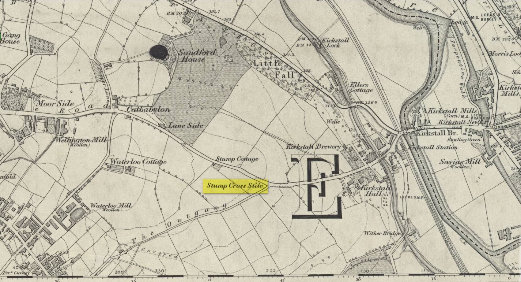
In medieval times an old stone cross was erected at the edge of Bramley where two old tracks once met, and which today is the junction where Broad Lane meets with Outgang Lane.  The cross is long gone – and even the stone cross base on which it stood no longer existed when the Ordnance Survey lads came here in the 1840s.  All that remained when they came here were the place-names which have forever kept a memory of its former existence: Stump Cross Stile and Stump Cottage.  It was mentioned, albeit briefly, in Wardell’s (1890) survey of Kirkstall Abbey where he told simply that a

“stone cross formerly stood some distance south of the Abbey by the side of the Old Road to Bradford, at the junction of the lane leading to Bramley, called the Outgang, but no remains of it are left; the site, however, is still known by the name of ‘Stump Cross Stile.’  Whether this cross marked the extent of some boundary, or was erected by the monks or others for the purposes of devotion for wayfarers, I am unable to ascertain.”

References:

  1. Wardell, James, An Historical Account of Kirkstall Abbey, Yorkshire, Samuel Moxon: Leeds 1890.

Acknowledgements:  Huge thanks for use of the Ordnance Survey map in this site profile, reproduced with the kind permission of the National Library of Scotland

© Paul BennettThe Northern Antiquarian

St Peter’s Well (1), Leeds, West Yorkshire

Holy Well (destroyed):  OS Grid Reference – SE 2894 3382

Archaeology & History

St Peters Well on 1852 map

Not to be confused with the other St. Peter’s Well that once existed in the city centre, this site was shown on an 1815 map of Leeds (which I’ve not been able to get mi hands on!), known as the Waterloo Map.  But when the Ordnance Survey lads visited the place in 1846, it had been covered over.  Immediately west of here, the saint’s name was also given to a nearby hill, whose folklore seems has been forgotten.

Although Ralph Thoresby mentioned it in passing, Edward Parsons (1834) gave us a brief description of its qualities, telling us that,

“Near North Hall is the celebrated spring called St. Peter’s Well ; the waters are so intensely cold that they have long been considered very efficacious in rheumatic disorders.”

Bonser (1979) reiterated this in his survey, also telling that, like its nearby namesake, its waters were “intensely cold and beneficial for rheumatism, rickets, etc.”  An old bathing-house that was “annexed to the Well” may have been used specifically to treat such ailments, but we cannot say for sure.

Interestingly, Andrea Smith (1982) told that 400 metres away a well was sunk in 1838 and a quantity of petrified hazelnuts were recovered from a broken red jar which had a female head painted on it.  Such a deposit is not too unusual, as a number of sacred wells in bygone days were blessed with nuts and signified the deity Callirius, known by the Romans as Silvanus, the God of the Hazel Wood – though we have no direct tradition here linking St. Peter’s Well with this ritual deposit.

St. Peter’s festival date was June 29.

References:

  1. Bonser, K.J., “Spas, Wells and Springs of Leeds,” in The Thoresby Miscellany – volume 54, Leeds 1979.
  2. Hope, Robert Charles, Legendary Lore of the Holy Wells of England, Elliott Stock: London 1893.
  3. Parsons, Edward, The Civil, Ecclesiastical, Literary, Commercial and Miscellaneous History of Leeds, Halifax, Huddersfield, Bradford, Wakefield, Dewsbury, Otley – volume 1, Frederick Hobson: Leeds 1834.
  4. Smith, Andrea, ‘Holy Wells Around Leeds, Bradford & Pontefract,’ in Wakefield Historical Journal 9, 1982.
  5. Thoresby, Ralph, Ducatus Leodiensis, Maurice Atkins: London 1715.

© Paul BennettThe Northern Antiquarian